
39A
Description
Ascent to Ostry Tolbachik via the Western ridge. Route 3–6 cat. sl.
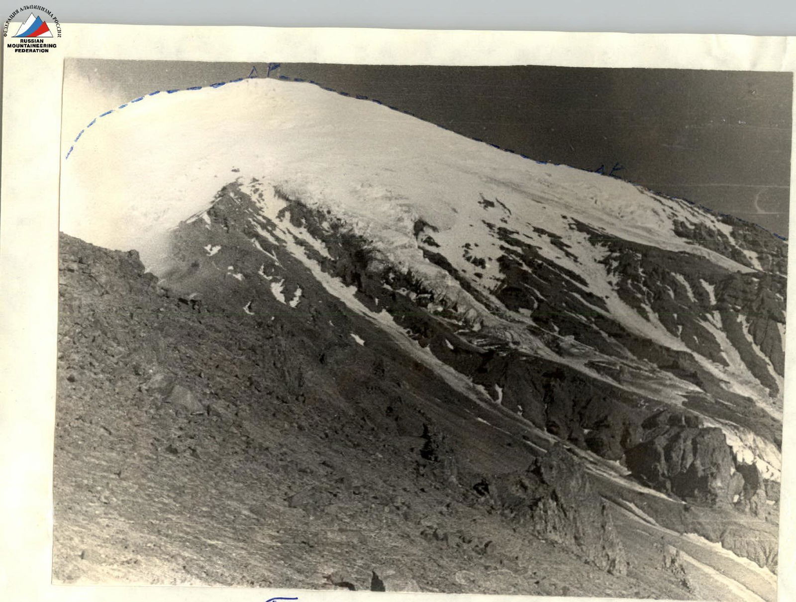
Ostry Tolbachik
Passage of the 3rd route. △ — overnight stay locations. R — control tour.
The beginning of the approach description to the stream is given in the description of the north-western route. Along the stream descending from the plateau, which approaches the north-western ridge, descent into the valley, separating the north-western ridge and the western one. The descent runs along grassy slopes and is technically simple. Having descended into the valley, it can be seen that to the right of the descent direction the western ridge is bristling with rocky pillars, and to the left glaciers descend into the valley. Having descended into the valley, we turn left along the track to a prominent cliff from the western ridge; this cliff must be bypassed from the western side along grassy slopes, which lead to a grassy glade. The glade encircles this cliff in a semicircle and is easily bypassed from the south-western side.
This place is the starting point of the ascent in the western direction. The time required for the approach from the stream with descent and ascent is 1.5–2 hours. Height above sea level is 1600 m.
Route description by sections
The height gain from the start of the ascent to the highest point of the massif is 2068 m. The count is from the proposed start of the ascent.
R1 — height difference 520 m. Steepness from 15° to 25°. The ridge is composed of large slate slabs. At the site's lowering — a control tour. Travel time — 2 h 30 min.
R2 — height difference 170 m. The ridge is sharp with gendarmes. Movement in rope teams with simultaneous belay. Steepness from 20° to 30°. At the end of the ridge, on the last gendarme — a control tour. Travel time 1 h 30 min.
R3 — height difference 260 m. The rocky ridge ends, and the path goes further along the snow-ice ridge. Steepness from 45° to 60° — pure ice. Move in rope teams with alternate belay and in some places with step cutting. Time 4 h. Everyone wears crampons.
R4 — height difference 180 m. Steepness 35–40°. Movement in rope teams. Simultaneous belay. Travel time — 1 h.
R5 — height difference 220 m. Steepness — 35–40°. Movement in rope teams with simultaneous belay and step cutting. At the beginning of the section there are 60 steps. Crampons do not grip the ice. Travel time 2 h 20 min.
R6 — height difference 210 m. Steepness 30–40°. Simultaneous belay, increased attention — crevasses. Travel time 1 h 30 min.
R7 — height difference 220 m. Steepness 35–45°. Simultaneous belay in places, via ice axe. Travel time 2 h.
R8 — height difference 140 m. Steepness 45–60°. Simultaneous belay with step cutting (120–130). Travel time 3 h.
R9 — height difference 82 m. Steepness 40–45°. Simultaneous belay via ice axe. Travel time 2 h.
The ninth section leads to the summit, where you can choose a place to overnight, dig a cave in the snow or set up tents.
Descent from the summit
Descent via route 2Б cat. sl. from the north, classified in 1971. The first 200 m with simultaneous belay. Then about 350 m with alternate belay via pitons.
Further, we come out onto a rocky ridge and go along it in rope teams down to a height of 1800 m. Along the ridge — to the Bystry river. Time — 6 h. Then we cross it and on the right side along the track we go for 2 h. The bank turns into a steep descent, and, not reaching the descent, in front of the rocky massif, you need to descend to a glade with a lake and follow along the marshy lowland, which gently descends to the Bystry stream. The Bystry river must be crossed, and on the left side along the descent track there is a well-trodden trail. Travel time 1 h. The trail leads to the shepherds' hut. It takes 45 min to walk along it.
Time calculation by days and hours
1st day
Transition from the shepherds' hut to the start of the route. Time — 5 h 30 min.
R1 — 2 h 30 min. R2 — 1 h 30 min.
Total travel time on the first day — 9 h 30 min.
2nd day
R3 — 4 h. R4 — 1 h. R5 — 2 h 20 min. R6 — 1 h 30 min. R7 — 2 h. R8 — 3 h. R9 — 2 h.
Total travel time on the 2nd day — 15 h 50 min.
3rd day
Section I — 6 h. Section II — 2 h. Section III — 1 h. Section IV — 45 min.
Total travel time on the 3rd day — 9 h 45 min.
Recommendations for climbers
- Main rope — 3 pcs. 40 m each.
- Ice pitons — 12 pcs.
- Crampons — 6 pairs.
- Climbing hammers — 2 pcs.
- Group karabiners — 6 pcs.
- Personal equipment.
- Avalanche shovels — 1–2 pcs.
First ascent made from August 1 to 3, 1971. Description compiled on October 19, 1971 by V. Kosov.
Comments
Sign in to leave a comment