RUSSIAN MOUNTAINEERING FEDERATION 46c. p/p order 532 of 27.12.83 ASCENT PASS.
- Ascent category — first ascent category
- Ascent area — Kamchatka, Klyuchevskaya volcanic group
- Summit — Kamen volcano, height 4650 m
Route 4. Expected category — 5B 5. Route characteristics — height difference — 2050 m, section length: * 5th category — 260 m * 6th category — 40 m
average steepness — 50°
6. Number of pitons: * for belay — 114 * for artificial anchors — 19, including: * rock — 5 * ice — 14
-
Number of walking hours — 31 h
-
Number of bivouacs — 5
-
Bivouac characteristics:
- First bivouac — platform under a tent, carved on a 30° slag-ice slope — 2 h.
- Second bivouac — platform under a tent, laid on a rocky ridge 45° — 3 h.
- Third bivouac — —"— .
- Fourth bivouac — platform under a tent, carved on a 30° ice slope — 2 h.
- Fifth bivouac — platform for a sitting bivouac, carved on a descent, icy 40° ridge in the nate ice — 3 h.
-
Full name of the team leader, participants, their qualification:
- Nikolai Kalyuzhny — captain, Candidate for Master of Sports, instructor/3rd category
- Oleg Loboda — participant, Candidate for Master of Sports, instructor/3rd category
- Igor Loginov — —"—, Candidate for Master of Sports, instructor/3rd category
- Anatoly Sazonov — —"—, Candidate for Master of Sports.
-
Team coach — Anatoly Gusak, Candidate for Master of Sports, 2nd category.
-
Departure date — August 18, 1983
-
Return date — August 24, 1983
Received on 19.10.83 www.alpfederation.ru↗
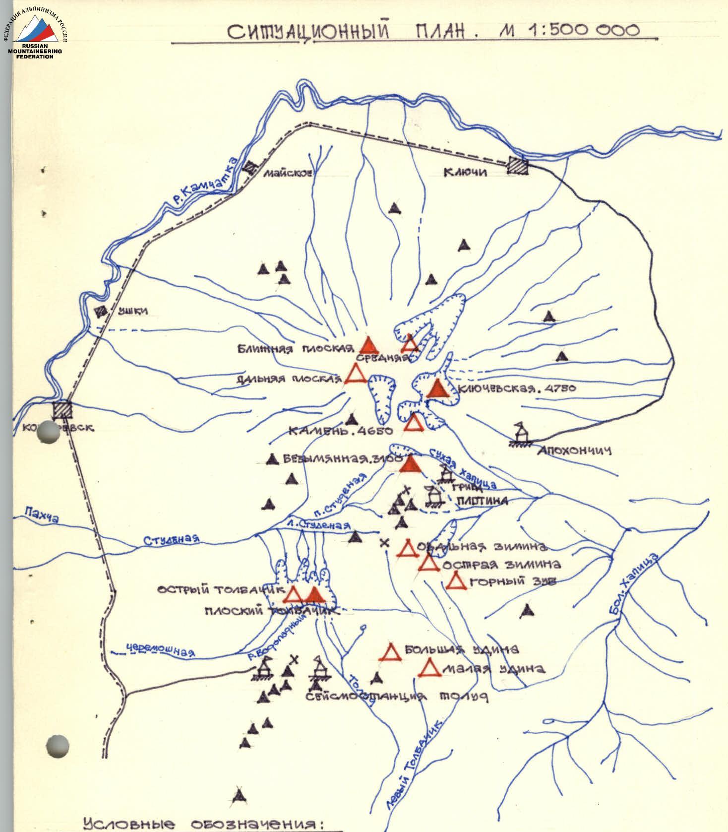
SITUATIONAL PLAN. SCALE 1:500 000
Conventions:
- Active volcanoes
- Extinct volcanoes
- Small cones
- Passes
- Glaciers
- Roads
- Volcanic stations
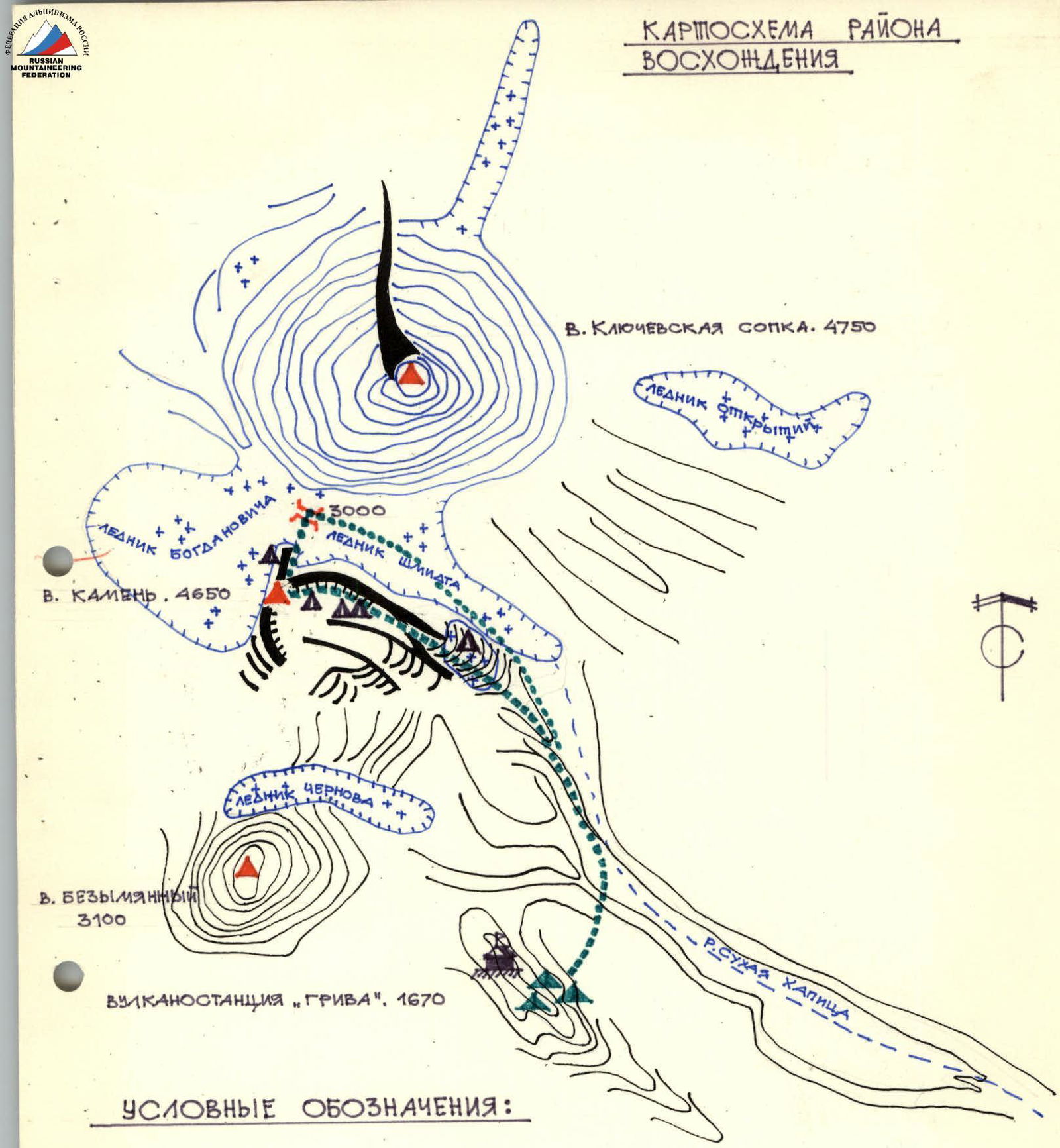
Ascent Area Map

Ascent Area
In the central part of Kamchatka, between the Sredinny and East Kamchatka ridges, is one of the most active volcanic regions — the Klyuchevskaya group of volcanoes.
The area is interesting from an alpinist's point of view. Many peaks have classified routes, but they generally do not exceed category 3A. Only one volcano — Kamen, occupies a special position: routes on the simplest slopes are rated 3B and 4A.
Kamen volcano (4650 m), an extinct volcano, is located between very "active" neighbors. To the south is one of Kamchatka's most active volcanoes — Bezymyanny (3100 m), to the north — the highest active volcano in Europe and Asia — Klyuchevskoy (4750 m).
If Klyuchevskoy and Bezymyanny have the shape of regular truncated cones (characteristic of volcanoes), then Kamen is striking primarily due to its asymmetry: to the south it breaks off with a more than two-kilometer wall — a collapse formed as a result of a giant explosion during a catastrophic eruption in the distant past. The remaining slopes are covered with:
- a permanent ice sheet, with a steepness of 40–45°,
- numerous cracks,
- and landslides.
In its structure, Kamen volcano belongs to stratovolcanoes — loose rocks alternate with solid ones, which is clearly visible from the side of the south wall.
When organizing an ascent to Kamen volcano, it is necessary to take into account that:
- Kamen volcano and Klyuchevskoy volcano are the northernmost four-thousanders in our country. Summer here is short and cold (1.5–2 months);
- the proximity of the ocean determines unstable weather — a cyclone with hurricane-force winds and heavy precipitation can arrive at any moment. (During the gathering, a cyclone/bad weather lasted for three days, the wind reached 35–40 m/s);
- the Klyuchevskaya group is an area of high seismic activity, which, in the presence of loose rocks in the structure of volcanoes, creates increased rockfall hazard.
Route Reconnaissance
On August 14, the team as part of the gathering of the Russian Council of the DSO "Urozhay" arrived in the area of the base camp located under Bezymyanny volcano.
From August 15 to 17, visual observation of the route was carried out (the ridge is clearly visible from the base camp).
On August 16, team members made a reconnaissance exit under the Eastern ridge of Kamen volcano. Having reached the Schmidt Glacier, they examined the route. The main attention was paid to identifying rockfall-prone areas and the possibility of passing key sections of the route.
From consultations with volcanologists and as a result of visual observations, it was established that the first key section — a 60 m vertical wall in the middle of the route — has an agglomerate structure.
During the reconnaissance exit, areas with a similar structure were found:
- a sintered mass of loose eruption products,
- with inclusions of individual stones.
On vertical sections, free climbing is practically impossible, since many stones fall out under load. Only ice pitons — "carrots" — were suitable for organizing belay and creating artificial anchors.
Given the presence of loose rocks on the route, a large supply of "carrots" was taken for the ascent.
The places of the planned bivouacs turned out to be the most optimal in terms of safety.
The team's safety was insured by a rescue team of 10 people, 1st sports category and Candidate for Master of Sports.
Approach to the Route
From the base camp located at the foot of Bezymyanny volcano at the "Griva" volcano station:
- move east, towards Klyuchevskoy volcano, to the canyon, 30 min.
- cross the canyon (rockfall hazard!).
- then, along the southern slopes of Kamen volcano, to the upper reaches of the Sukhaya Khapitsa river, 1 h.
- ford (very difficult in the second half of the day!).
Beyond the ford, climb left onto the ridge going towards Kamen volcano, along the Schmidt Glacier.
Further ascent along the right (orographic) part of the Schmidt Glacier.
After 1.5 h of walking along the ridge:
- descend with a slight decrease in the ridge to the right onto the glacier.
Movement on the glacier with crampons. When approaching the slopes of Kamen volcano — rockfall hazard!
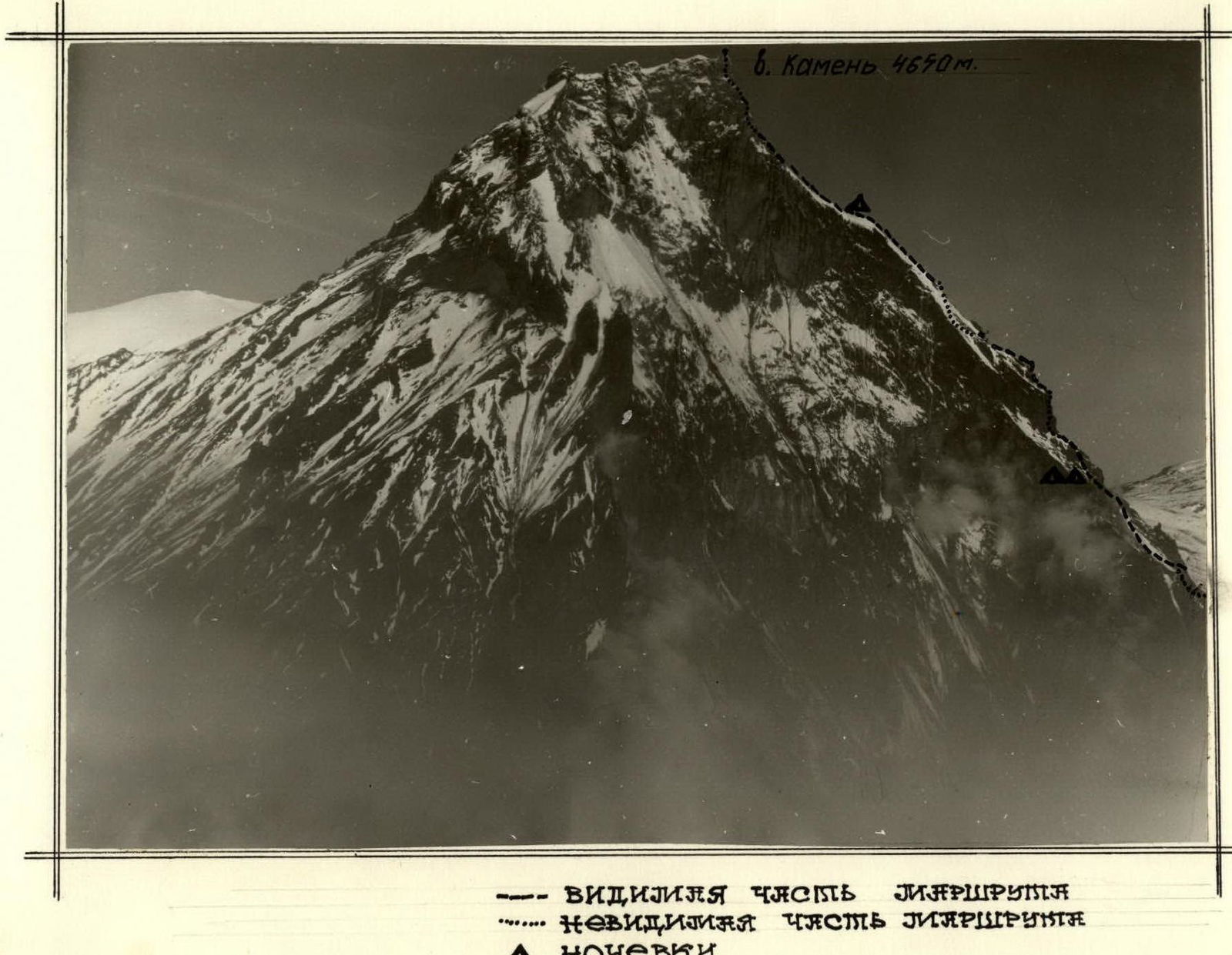
After 3 h of walking — exit to the base of the Eastern ridge. The beginning of the route — 20 m gray pinnacle, under which a control cairn is built.
The journey from the base camp to the start of the route takes 6 h.
Route Description
The route begins from the 20 m gray pinnacle in the lower part of the Eastern ridge at an altitude of 2600 m.
On the platform under the pinnacle — a control cairn. Up from the pinnacle along a 35° slope (40 m, 35°) to the right-up into the base of the ice couloir (40 m, 40°). Belay is piton. Behind the couloir along an icy slope (80 m, 35°) — exit to the ridge.
Along a heavily destroyed ridge (200 m, 40°) — movement with piton belay and through ledges. The ridge leads over destroyed pinnacles, which are bypassed on the right along the ice (50 m, 47°).
The further path goes to the right of the ridge along an ice slope (300 m, 45°). Rockfall hazard! Belay through ice screws. Exit to a rocky ridge, movement along it (150 m, 47°) to the first key section — a 60 m vertical wall.
Not reaching 80 m to the wall (further — very rockfall-prone!) — first bivouac. There are no platforms under a tent along the entire length of this section of the route.
From the bivouac to the right-up along the ice (30 m, 40°), towards a vertical rock vein cutting through the looser rock of the wall. To the vein (20 m, 90°) — climbing with artificial anchors. Ice pitons of the "carrot" type were used for belay and artificial anchors. The rock vein is heavily destroyed! (40 m, 85°). Climbing is difficult, belay is piton.
Further — exit to the base of an ice couloir (50 m, 70°). The base of the couloir is nate ice, the walls are composed of soft rocks. Climbing is very difficult. Belay through ice pitons.
From the couloir, exit to an icy slope (70 m, 45°). Ascent to the ridge, movement along the ridge (80 m, 35°) with a transition to an ice slope. Along the ice (150 m, 35°), ascent to the pre-summit snow-ice ridge. Along the ridge (200 m, 30°, crevasses!) — approach under the bergschrund bordering the summit tower.
Second bivouac. On this section of the route, a platform under a tent can only be carved on the pre-summit ridge.
From the bergschrund along an ice slope (80 m, 65°) — exit under the rocks of the summit tower — the 2nd key section of the route. Along a vaguely expressed internal corner (30 m, 75°), climbing is more difficult, exit to a rocky ridge.
Along the ridge (30 m, 45°) — approach to a rocky wall (20 m, 90°), climbing is very difficult, artificial anchors. From the wall to the right-up is an inclined shelf (15 m, 35–40°), there are few footholds, climbing is very difficult. Further — exit to snow-covered rocks (45 m, 55°), climbing is more difficult. Along the rocks, exit to the summit. From the summit, descent towards the Bogdanovich Glacier onto the pass between Kamen volcano and Klyuchevskoy volcano along a route of category 4A.
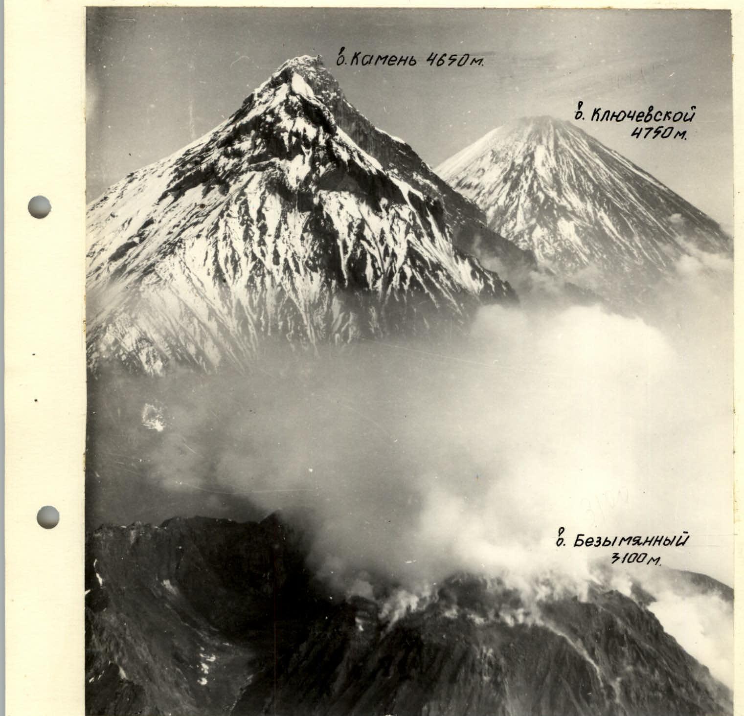 Kamen volcano. 4650 m.
Route diagram according to Uily. Kamen volcano, 4650 m. Eastern ridge.
- R21 45 m, 55°, V+
- R22 15 m, 35°, V+
- R19 20 m, 90°, A6
- R18 80 m, 45°, IV
- R17 30 m, 75°, V+
- R16 80 m, 65°
- R15 200 m, 30°
- R14 150 m, 35°
- R13 80 m, 35°, III+
- R12 70 m, 45°
- R11 50 m, 70°
- R10 40 m, 85°, V+
- R9 20 m, 90°, A6
- R8 80 m, 40°
- R7 150 m, 47°, IV+
- R6 300 m, 45°
- R5 50 m, 47°
- R4 200 m, 40°, IV+
- R3 80 m, 35°
- R2 40 m, 40°
- R1 40 m, 40°
- R0
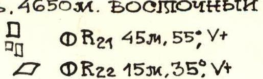


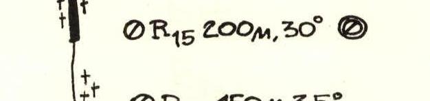


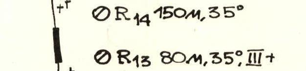

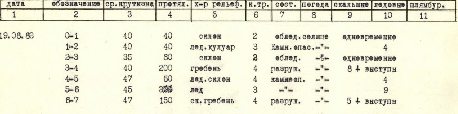
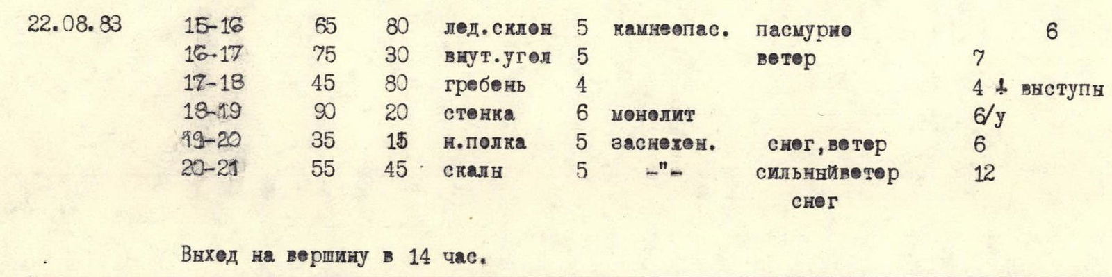
TABLE OF MAIN CHARACTERISTICS OF THE ASCENT ROUTE
| Date | Designation | Average Steepness | Length | Terrain Characteristics | Category | Condition | Weather | Rock Pitons | Ice Pitons | Bolts |
|---|---|---|---|---|---|---|---|---|---|---|
| 19.08.1983 | R0–R1 | 40° | 40 m | slope | 2 | icy | sun | simultaneous | ||
| R1–R2 | 40° | 40 m | ice couloir | 3 | rockfall | — | 4 | |||
| R2–R3 | 35° | 80 m | slope | 2 | icy | — | simultaneous | |||
| R3–R4 | 40° | 200 m | ridge | 4 | destroyed | — | 8 | ledges | ||
| R4–R5 | 47° | 50 m | ice slope | 4 | rockfall | — | 4 | |||
| R5–R6 | 45° | 300 m | ice | 3 | — | — | 9 | |||
| R6–R7 | 47° | 150 m | rocky ridge | 4 | destroyed | — | 5 | 4 | ledges |
Bivouac stop at 16:00. Bivouac on a platform laid on the ridge. Departure at 8:00.
| 20.08.1983 | R7–R8 | 40° | 80 m | ice slope | 3 | rockfall | rocks, ledges | |||
|---|---|---|---|---|---|---|---|---|---|---|
| R8–R9 | 90° | 20 m | wall | 6 | rockfall | cold | 10 | 11 | ||
| R9–R10 | 85° | 40 m | — | 5 | loose rock, destroyed | wind | 12 | 2 |
At 16:30, descent by rappel to the previous bivouac site. Departure at 8:30.
| 21.08.1983 | R10–R11 | 70° | 50 m | ice couloir | 5 | rockfall | sun | 10 | 11 | |
|---|---|---|---|---|---|---|---|---|---|---|
| R11–R12 | 45° | 70 m | icy slope | 4 | — | strong | 3 | |||
| R12–R13 | 35° | 80 m | ridge | 3 | destroyed | wind | ledges | |||
| R13–R14 | 35° | 150 m | ice slope | 4 | rockfall | — | 7 | |||
| R14–R15 | 30° | 200 m | ice ridge | 3 | simultaneous |
Departure at 8:00. Passage of sections R8–R9, R9–R10 on fixed ropes. Bivouac stop at 17:00. Bivouac on a platform carved on a 30° ice slope.
Brief Geographical Description of the Klyuchevskaya Group of Volcanoes
The Klyuchevskaya group of volcanoes plain is one of the most interesting places in Kamchatka. Here, in the middle reaches of the Kamchatka River, where it makes a sharp turn to the east towards the ocean, a number of volcanoes are located on a lava-filled base, including the largest active volcano in Asia — Klyuchevskaya Sopka, and many cinder cones. Here, in a relatively small area, you can get acquainted with various types of volcanic activity and volcano forms, traces of recent violent eruptions of Bezymyannaya Sopka.
Here, in a relatively small area, you can:
- get acquainted with various types of volcanic activity and volcano forms,
- see traces of recent violent eruptions of Bezymyannaya Sopka,
- walk through various natural zones — from deciduous and birch forests to stony tundra, bare black rocks, powerful glaciers descending from the peaks of snow-covered volcanoes.
This area occupies an area of about 6500 km², including 225.2 km² — the area of glaciation.
Of all the volcanoes, the most interesting from an alpinist's point of view are:
- Klyuchevskaya Sopka — 4750 m
- Kamen — 4595 m
- Ploskaya Blizhnyaya Sopka — 4115 m
- Ploskaya Dalnyaya Sopka — 3943 m
- Ostry Tolbachik — 3682 m
- Plosky Tolbachik — 3085 m
- Ovalnaya Zimina — 3081 m
- Bolshaya Udina — 2923 m
- Srednyaya Sopka — 2990 m
- Bezymyanny — 2800 m
Routes start from the village of Kozyrevsk, located in the middle reaches of the Kamchatka River on its right bank. From the village by car to the south, along the power line to the intersection of the road and the Pakhcha River at the abandoned village of Srednyaya Kravcha.
From the village, a pedestrian or caravan transition along the Pakhcha River bed to its confluence with the Studenaya River. You should go along the left bank of the Pakhcha River and, stopping the caravan, find a tractor road and follow it. Gradually, the road turns into a trail. The trail is poorly visible, so you need to move carefully, preferably with a guide.
The Pakhcha River is formed as a result of the division of the Studenaya River by a dam. After 4–5 h, the trail leads again to the river about 100 m above the stone gates that compress the river and make it impassable. Here you should organize a crossing and move to the right side of the river, already Studenaya. Then find a trail that goes along the bed of a dry stream and go up, constantly hearing the noise of the river on the left. It takes 2–3 h to reach a wide clearing with a large rocky shore on the left side. Ahead will be Bezymyanny volcano, Kamen, and the upper part of the Klyuchevskoy cone. To the right will be Ostry Tolbachik volcano. A house has been built on the clearing, which can accommodate 15 people. There are many berries, mushrooms, and game in the vicinity of the house. It is convenient to set up a base camp on this clearing. Within a half-hour walk from the clearing — good rocks for training, and within a 2–3 h walk — snow and glaciers. From here, it is convenient to make an ascent to Ostry Tolbachik:
- from the north along category 2B
- from the northwest along category 3B
- and also from the west along category 3B