
- Russia, Kamchatka Peninsula, Ganal Range, Ganal'skie Ostryaki area. Section # 3 KMGV.
- Ptitsa Peak (2006 m). Route: "via the North Ridge".
- Category proposed — 3B. First ascent.
- Type of route: mixed terrain.
- Elevation gain: 560 m.
Route length: 740 m. Rock climbing length: 190 m. Sections of grade 5 difficulty: 6 m. Average slope of the main route section — 58°.
- Pitons left on the route: total — 3;
Total equipment used on the route: rock pitons — 6, cams and nuts — 34, including aid climbing equipment — 6.
- Team's climbing hours: 8 hours.
- Team leader: Ivan Benedyk — 1st sports category.
Team members: Oleg Chirik — Candidate for Master of Sports, Evgeny Lysenkov — 2nd sports category.
- Coach: Valery Karpenko — Master of Sports.
- Departure from Base Camp: 6:30 AM, July 9, 2005.
Departure to the route: 9:00 AM. Summit reached at 5:00 PM. Return to Base Camp — 10:30 PM, July 9, 2005.
General photo of the summit
Route profile on the right
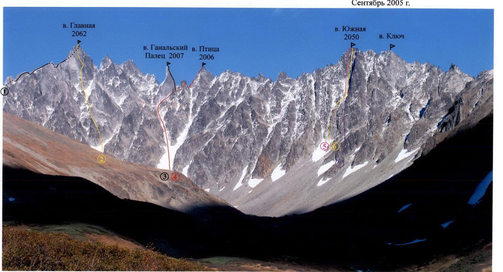
- "South-West Ridge". 5A category. F. Farberov, S. Panyukhin. 1991.
- "Via the North Ridge". I. Benedyk, O. Chirik, E. Lysenkov. 2005.
The photo was taken from a distance of 2000 m, height 1500 m. Point of observation # 2. Camera: Canon Power Shot Pro 1 (Zoom). August 8, 2005.
Photo of the route on the left
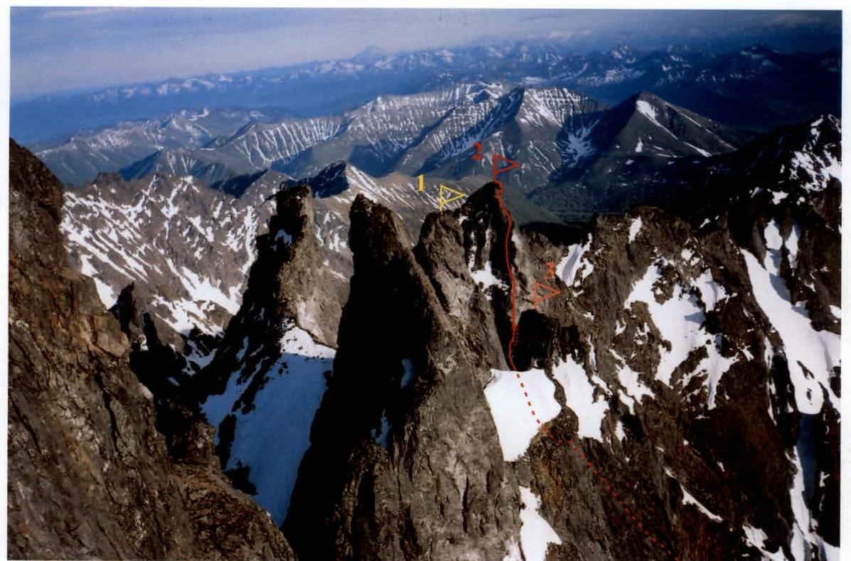
1 — "Ganal'skiy Palets" Peak (2007 m). 2 — "Ptitsa" Peak (2005 m). 3 — "Sunduk" Gendarme.
The photo was taken from the North-West wall of Glavnaya Peak. Point of observation # 3, height 2040 m, distance — 800 m. Camera: Samsung (35mm focal length). June 2004.
Panoramic photo of the "Ganal'skie Ostryaki" area
Point of observation # 1. Height 900 m. Camera: Canon Power Shot Pro 1 (Zoom). September 2005.
- "From the North-West", 3B category. Leader I. Korbuh. 1981.
- "Through the center of the South-West wall", 5B category. F. Farberov, S. Panyukhin, 1991.
- "Via the South Ridge", 5A category. F. Farberov, S. Panyukhin, 1991.
- "Via the North Ridge", I. Benedyk, O. Chirik, E. Lysenkov, 2005.
- "Through the center of the North-West wall". 5B category. F. Farberov, S. Panyukhin. 1991.
- "M-33" 5B category. I. Benedyk, O. Chirik, A. Bichenko, 2001.
- "Along the edge of the North-West wall". 5A category. A. Bichenko, A. Alekseev, I. Bekrin, 1995.
Map of the climbing area
Scale: 1:225 000

Petropavlovsk-Kamchatsky — 134 km.
- Palets Peak (2007 m).
- Ptitsa Peak (2006 m).
- Yuzhnaya Peak (2050 m).
Path to the Base Camp.
- Base Camp. 900 m.
- Point of observation # 1 — 1500 m.
- Point of observation # 2 — 900 m.
- Point of observation # 3 — Glavnaya Peak, South-West wall — 2040 m.
Brief overview of the climbing area
In the southern part of the Kamchatka Peninsula, within the Greater Eastern Ridge system, lies a unique and compact area — the Ganal Range (Ganal'skie Ostryaki). It stretches 20 km from north-west to south-east, and is about 10 km wide. The highest point is Glavnaya Peak (2062 m). The area is characterized by alpine-style mountains, with wall elevations reaching 450 m. Despite the relatively low absolute height of the peaks, winter lasts for nine months:
- First frosts occur in early September.
- Snowfall begins around September 15-20.
- Temperatures can drop to -45 °C in December-February.
- Snow at the Base Camp level melts only by mid-June.
Most ascents in the area are made during the summer. The most suitable period for expeditions is from mid-June. At this time, it's warm enough and there are no mosquitoes or midges that are a nuisance in July. The most stable and clear weather is in late August and early September.
Access:
- From Petropavlovsk-Kamchatsky, it's convenient to drive to the bridge over the Vaktan Malkinsky River (144th km of the Milkovo highway, see the area map).
- After the bridge, turn right and drive 5-6 km on a forest road.
- Then, continue on foot or by off-road vehicle for another 5 km to the entrance of the gorge on the left (the first tributary of the Upper Malkinsky River).
- The road ends here.
Path to the Base Camp:
- From there, go left, through the alder bushes, on a footpath.
- Follow the left side of the valley, upwards, until you reach a terrace.
- Cross a small stream at the boundary between the forest and the shrubs.
- The ascent to the upper valley takes 50-60 minutes.
- From this point, a panorama of the main peaks unfolds: Yurchik, Glavnaya, Palets, Ptitsa, Yuzhnaya (point of observation # 1).
- From here to the Base Camp is 3 km.
- Move along the left slope of the tributary flowing from Yurchik Peak.
- After 300 m, cross the tributary and head towards the cirque, until you reach the cedar trees on the moraine cushions.
- Here, near the right side of the gorge, under a distinct pass, is a good location for the Base Camp.
Travel time:
- Drive from the city to the Vaktan Malkinsky River — 2.5 hours.
- Walking distance — 10 km, 3.5-4 hours.
Helicopter landing:
- A helicopter can land in the Ganal'skie Ostryaki cirque.
- Flight time — 30 minutes.
Approach to the route:
- From the Base Camp, go up the gorge, on the stony moraine — 1.5 km to a large snowfield that covers the bottom of the cirque.
- Then, move straight up the steep snow towards the couloir descending from Palets and Ptitsa Peaks.
- Here, near the rocks, is the start of the ice and snow section of the route.
- Time to reach the route — 1.5 hours.
Technical photo of the route
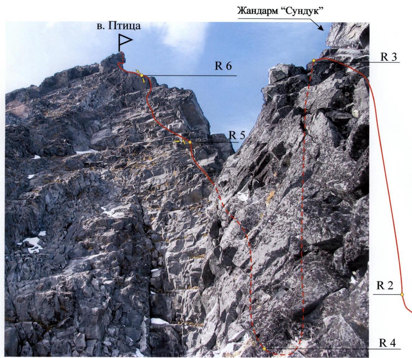
R — belay station (section number). Arrows indicate the direction of the photo:
- R5 — photo #2, 3
- R6 — photo #4, 5
Route diagram in UIAA symbols
Scale: 1:1000
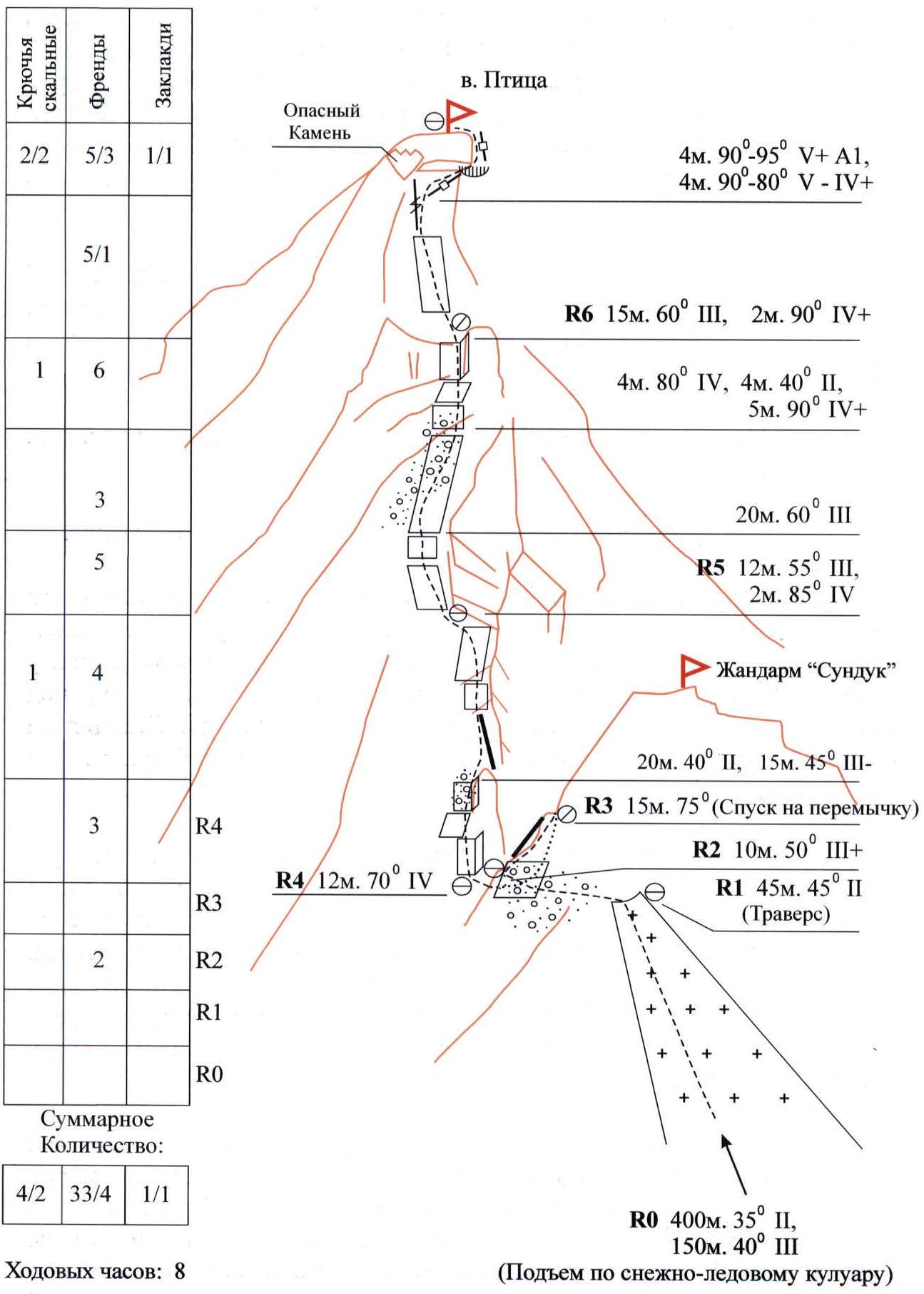
Route description by sections
Section R0
The start of the route is from the first rock outcrops (height 1500 m) of a wide snow couloir leading to the saddle between Palets Peak and Sunduk Gendarme. Move up the couloir, bypassing two smaller couloirs on the right*, towards Palets Peak. The upper part of the couloir narrows, with crevasses and ice sections. The slope reaches 40° or more. The length of this section is about 600 m.
Section R1
From the saddle between Palets Peak and Sunduk Gendarme, traverse 45 m towards Ptitsa Peak. Move along the left side of the gendarme. The rocks are broken. The belay station is on large boulders before a steep rock depression.
Section R2
Climb straight up 10 m along the broken ridge to a small ledge. The belay station is on a rock outcrop.
Section R3
Descend 15 m with a rappel from the gendarme to a connecting ridge under the tower of Ptitsa Peak.
Section R4
Start climbing the tower by moving up the left side of a vertical internal corner — onto an inclined slab and then along broken rocks — to reach the ridge. Continue along the ridge and through a series of small vertical steps and inclined slabs — to reach a rock bastion. Protection: medium-sized cams. The belay station is on an inclined slab under the bastion, with a forged horizontal piton and two cams (#1, #2)**.
Section R5
From the belay station, move left and up 12 m along the bastion and through a 2-meter wall to reach a 20-meter inclined slab, bounded on the left by a heavily broken couloir and on the right by the bastion. Climb up along the bastion. At the top of the slab, there's a small wall, tense climbing on unreliable holds, and then a 5-meter vertical internal corner, grade 4 difficulty. Protection: medium-sized cams and pitons. The corner leads to the start of a 15-meter inclined slab. The belay station is on reliable crack systems for cams #4-#6.
Section R6
From the belay station, climb 15 m up a smooth, narrow slab to reach a 6-meter vertical wall ending in a 2-meter cornice, forming the "beak of Ptitsa", visible from the Base Camp.
On the wall, climb up a crack under a large, unreliable rock resembling a "spade" sign. Be cautious, as the rock is not secure and should not be loaded.
From the rock, traverse 4 m to the right and up along a thin, diagonal crack on a smooth wall, bypassing the cornice. Tense climbing of grade 5 difficulty with aid climbing. Above the cornice, climb 4 m up, on rocks covered with lichen, making climbing even more challenging — to reach the summit.
Protection: cams #00-#4, pitons.
The summit is a moss-covered horizontal platform, 2 by 8 m. Descent from the summit is via the ascent route.
* At a height of about 1650 m (section R0), a narrow couloir joins from the right, leading to a connecting ridge between Sunduk Gendarme and Ptitsa Peak. This couloir is characterized by steepness, reaching 45° or more, with ice and rock sections (especially towards the end of summer), and frequent rockfall. Climbing this couloir is not recommended.
** The team used cams of the following sizes:
Spring-loaded cams:
- #00 — for cracks 10–12 mm wide
- #0 — 12–15 mm
- #1 — 14–18 mm
- #2 — 18–23 mm
- #3 — 20–25 mm
- #4 — 24–30 mm
Rigid cams (Friends):
- #1 — 28–33 mm
- #2 — 30–43 mm
- #3 — 38–50 mm
- #4 — 47–57 mm
- #5 — 54–67 mm
- #6 — 63–83 mm.
Photo #1
Section R4
Start of the ascent to the summit tower
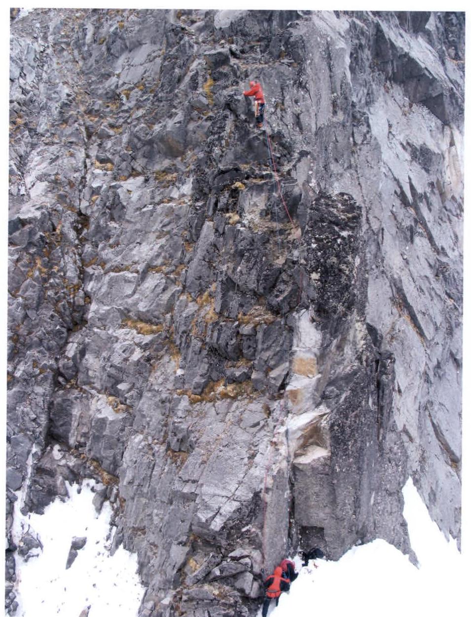
The photo was taken from Sundk Gendarme. Camera: Canon Power Shot Pro 1 (Zoom). July 9, 2005.
Photo #2
Belay station R5
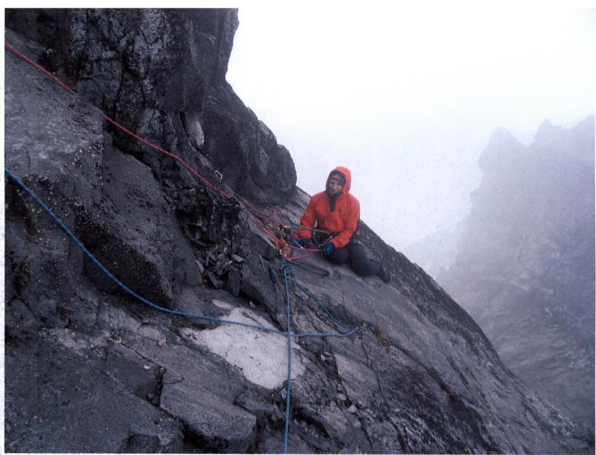
The photo was taken from the belay station of section R5. Camera: Canon Power Shot Pro 1 (Zoom). July 9, 2005.
Photo #3
Section R5
Approach to the belay station of section R6.
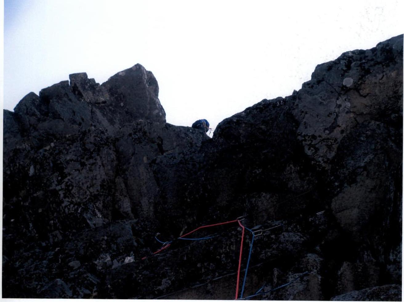
Photo #4
View from belay station R6 on sections R4–R5

The photo was taken from the belay station of section R6. Camera: Samsung (35mm focal length). July 9, 2005, 9:00 AM.
Photo #5
Section R6
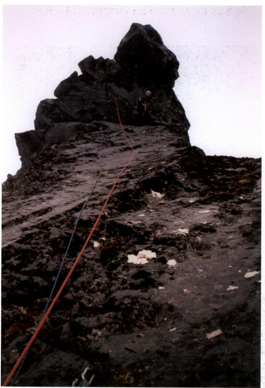
Passage of the summit section of the route: V+ category, A1.
The photo was taken from the belay station of section R6. Camera: Samsung (35mm focal length). July 9, 2005, 9:00 AM.