Alpinism and Rock Climbing Federation
of Arkhangelsk Region
Russian Championship in Alpinism
Technical and High-Altitude Class
Report
On the ascent of the team from Arkhangelsk Region and Tatarstan Republic to the summit of Erydag Northwest, 3887 m, via the cornices of the central part of the right bastion of the NW wall, following Shanovazov's route, 2005, category 6B
Leader: Dmitry A. Rybalchenko Participants:
- Mikhail A. Veshchagin
- Rasim G. Kashapov Coaches:
- Sergey K. Penzov
- Valery S. Kudryashov
Responsible for the report: D.A. Rybalchenko, rybalchenko92@yandex.ru
Severodvinsk 2018
Ascent Passport
-
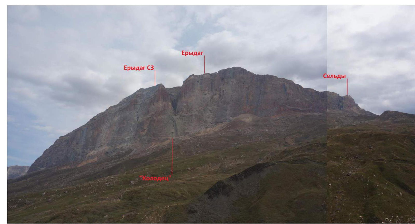
Region — Caucasus, Dagestan mountains (from Shaviklde peak to Bazardyuzy peak), Chekhychay gorge, p. 2.10
-
Peak — Erydag (NW), 3887 m, Shanovazov's route — 2005: via the cornices of the central part of the right bastion of the NW wall, category 6B
-
Route type — rock climbing
-
Route characteristics:
Height difference — 1167 m, wall section height difference — 1030 m, route length — 3025 m, wall section length (excluding the traverse along the ledges of the summit tower) — 1175 m, average slope — 64 °, average wall angle — 75 °, average bastion angle — 80 °, sections with 6B difficulty — 700 m, 5B difficulty — 200 m.
-
Equipment used on the route: stoppers/camalots – 25/123; anchor hooks – 116/71; 126 steps of artificial technical aids (ITOs) on "fifas"; 137 steps of ITOs on skyhooks; 33 bolts, pins, and spits; 57 removable bolts. 2 pins from bolt hooks were left on stations for platform installation.
-
Total product of walking hours — 56 h 35 min. Days — 5.5. Descent — 4.5 h via the classic route, category 1B. Nights — 5, all on the wall in platforms.
-
Leader: Participants:
Dmitry A. Rybalchenko — CMS (Severodvinsk) Mikhail A. Veshchagin — 1st sports category (Severodvinsk) Rasim G. Kashapov — CMS (Kazan)
-
Team coaches: Sergey K. Penzov — Master of Sports of International Class (Severodvinsk), Valery S. Kudryashov — CMS (Kazan)
-
Departure date:
On the route — at 07:30, October 4, 2018 On the summit — at 14:50, October 9, 2018 Return to Base Camp — at 19:30, October 9, 2018
-
Responsible for the report: D.A. Rybalchenko, rybalchenko92@yandex.ru
General photos
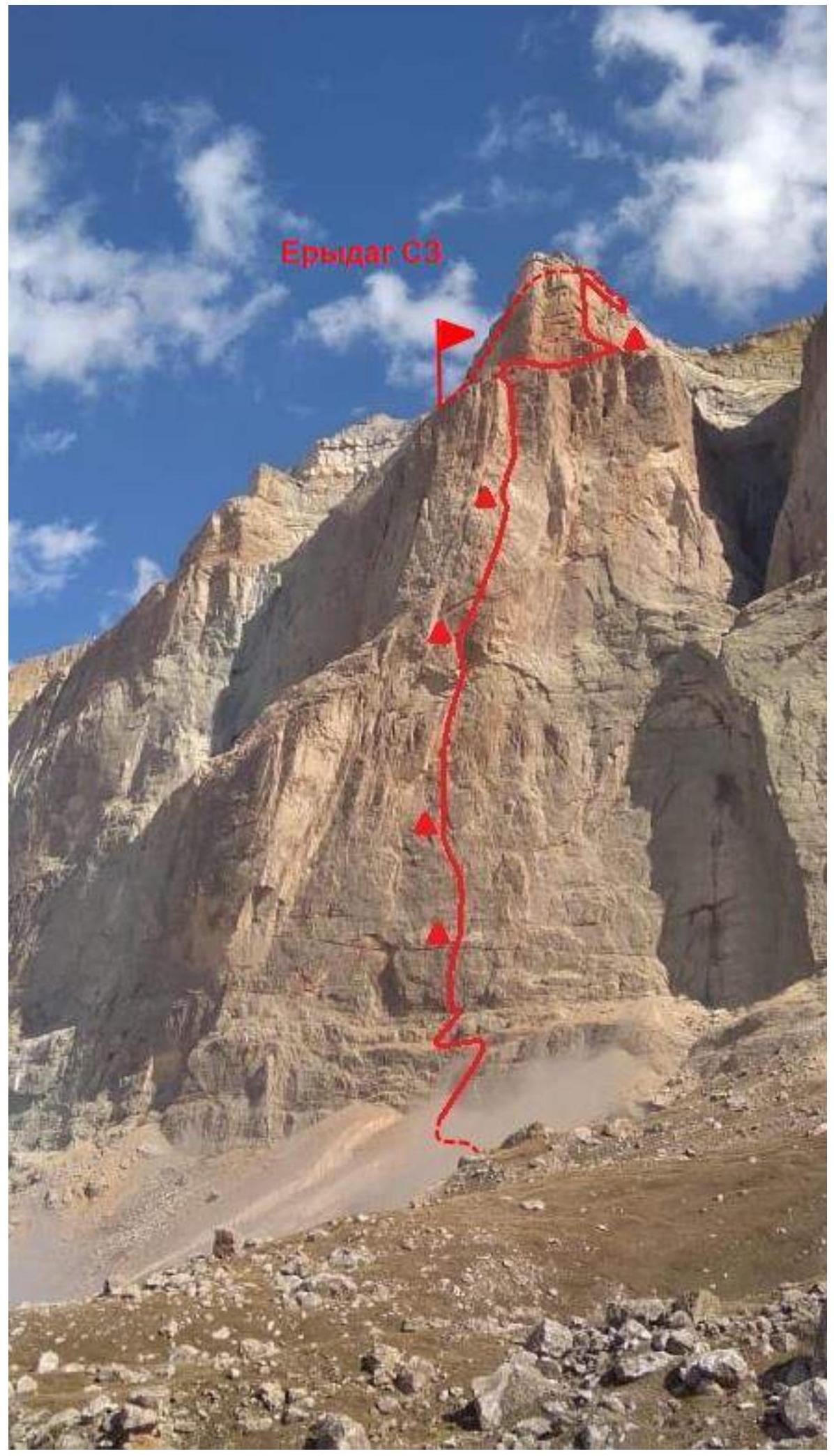
General photo of Shanovazov's route, 6B, Erydag NW, 3887 m
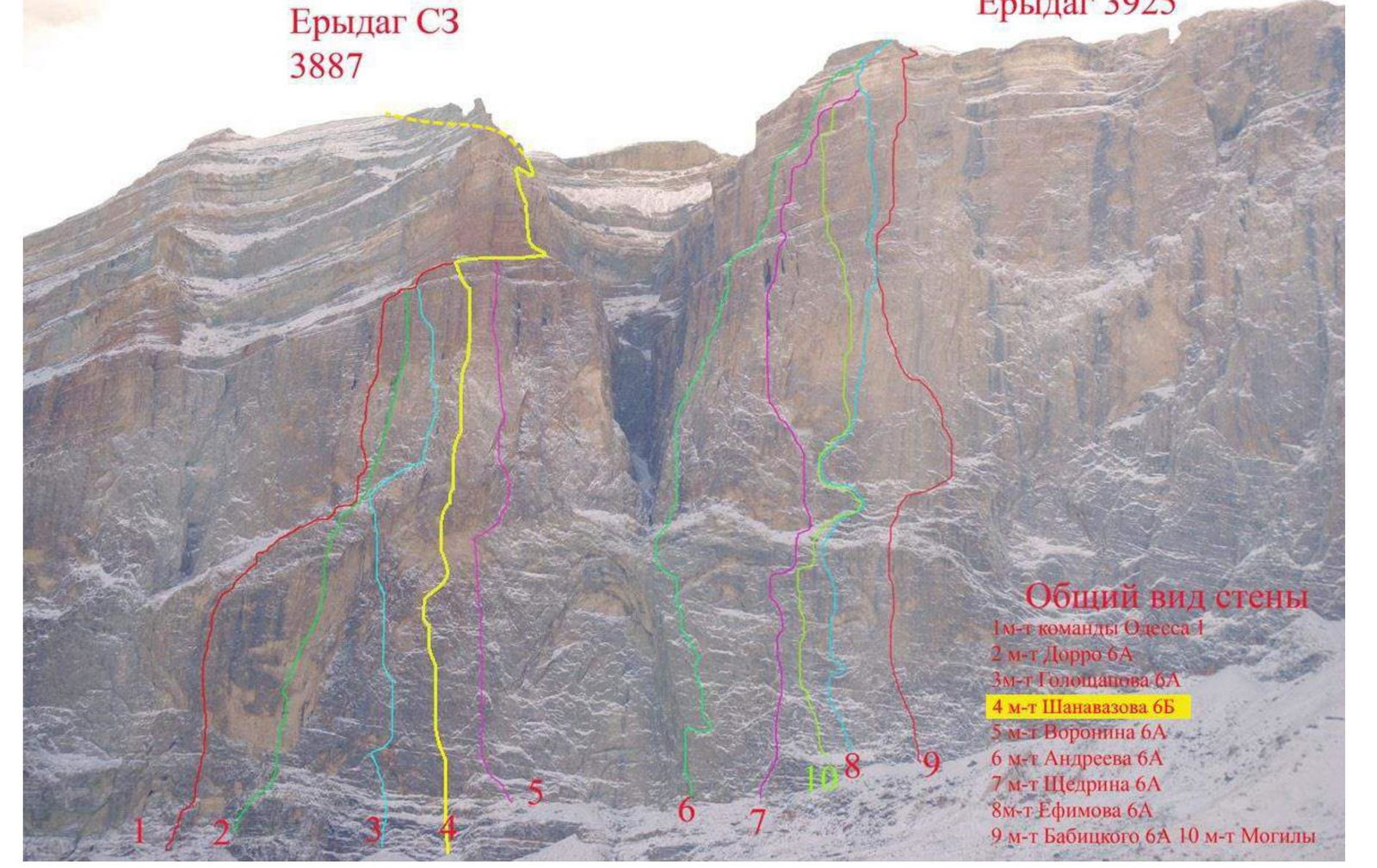
General view of the wall with other routes
Route profiles
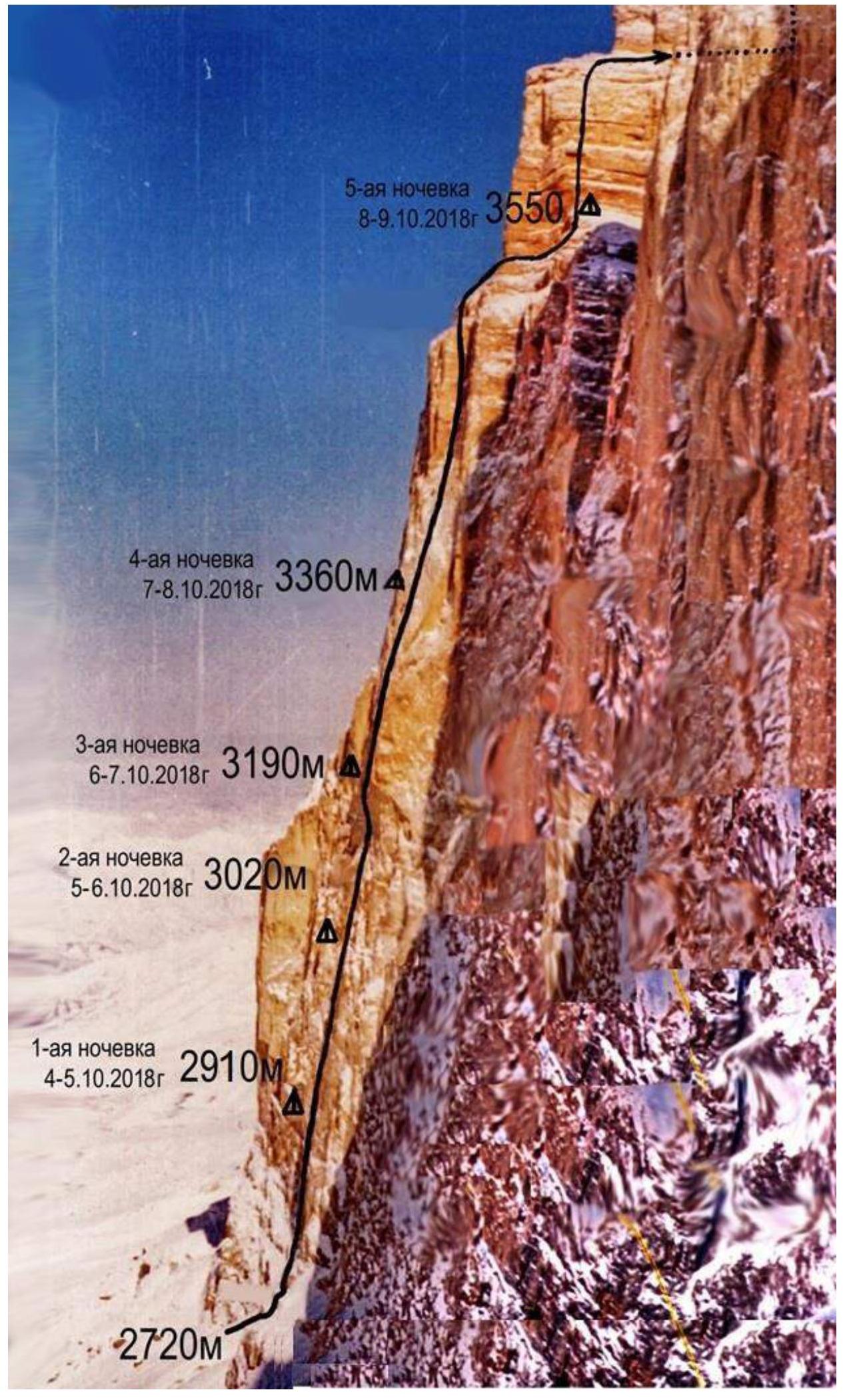

Profile scheme
Panoramas of the massif
General view of the massif
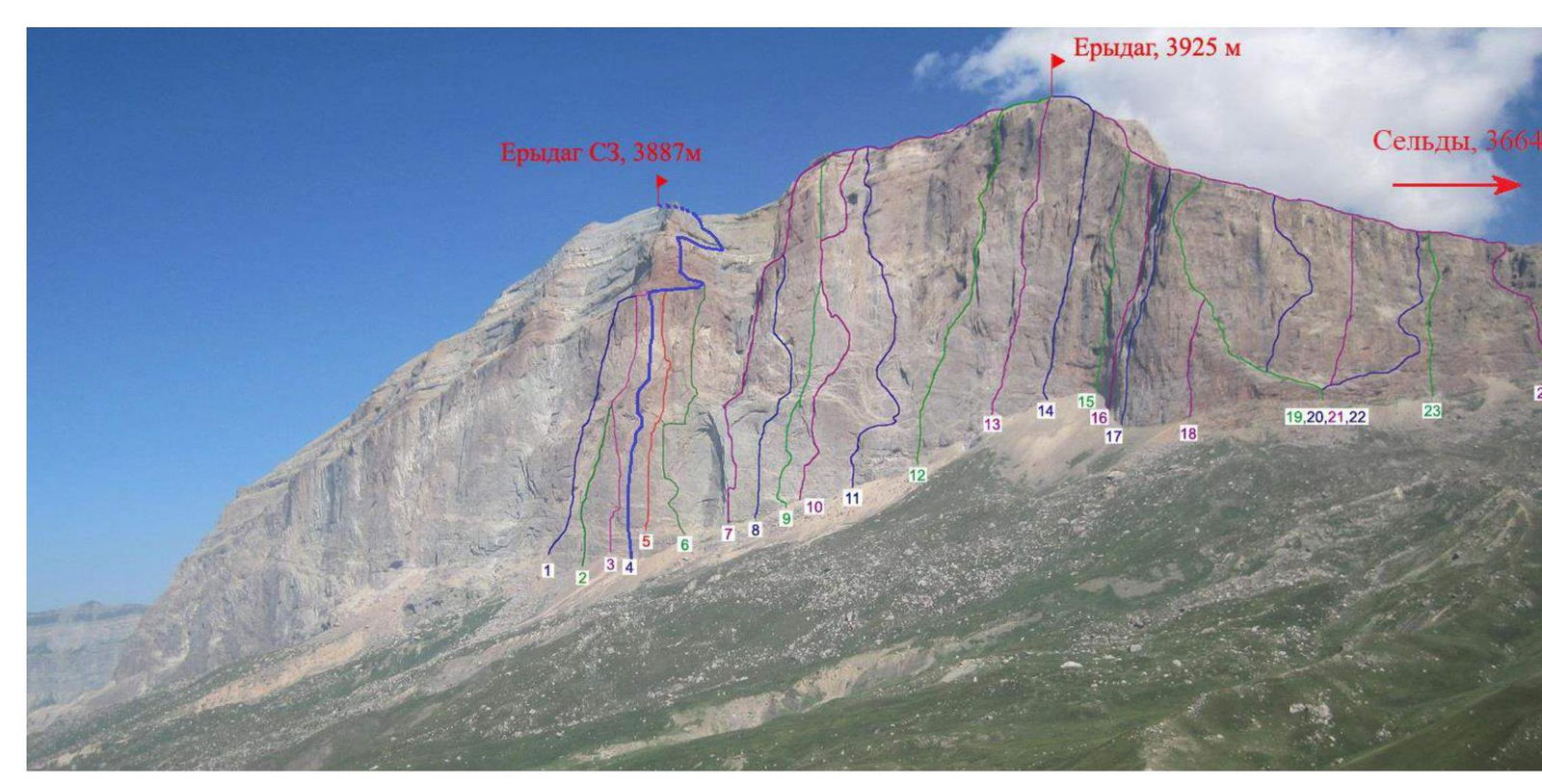
Panorama with routes
Description of the ascent area and brief ascent characteristics
The Erydag massif is located in a short northeastern spur of the Main Caucasian Range, on the border between Russia and Azerbaijan. It forms almost a single plateau with Yarydag and Shahdag. In Dagestan, the walls descend to a height of 300–1100 m. The wall is composed of metamorphosed limestones. The weather in the area is substantially more stable than in other parts of the Caucasus, but precipitation in the form of rain or snow is not uncommon. In winter, there is frosty, dry weather with periods of strong winds and precipitation (no more than 2–3 days). A major issue on the wall is the lack of water; snow does not stay on the wall, is blown away, and due to the dryness of the air, snow evaporates without melting. Below Erydag, there are several streams flowing out from under the wall.
Weather in the area:
- Substantially more stable than in other Caucasus regions
- Precipitation in the form of rain or snow is not rare
- Winter: frosty, dry weather with periods of strong winds and precipitation (no more than 2–3 days)
Problems on the wall:
- Lack of water
- Snow does not stay on the wall — is blown away
- Due to the dryness of the air, snow does not melt but evaporates
There are several streams flowing out from under the wall.
The area has numerous routes from category 1B to 6B. The highest point in the area is Mt. Bazardyuzy (4466 m), which is the highest peak in Dagestan and Azerbaijan. The area also includes the southernmost point of Russia, making the Erydag region the southernmost alpinism area in Russia. Since the southern part of the region is a border zone, it is necessary to obtain permits in advance. Border guards in this area are friendly and sympathetic to climbers and tourists.
Access to the ascent area from Makhachkala is via the federal highway "Caucasus" south to the village of Novy Gopcak (180 km), then right and up along the Samur River to the village of Usukhchai (225 km, 700 m above sea level). Then left along a dirt road up the Usukhchai River to the village of Kurush (250 km, 2500 m). 3–5 km downstream from Kurush is a hut built and provided for accommodation by Petr G. Leonov. The journey takes 6–8 hours.
The hut has all amenities, including electricity and internet. It can accommodate more than 20 people. A bathhouse is under construction. Petr G. Leonov can provide advice on the area and routes, help with organizing drop-offs, accommodation, document processing, and conducting alpine events. Contact him at leonov650328@mail.ru.
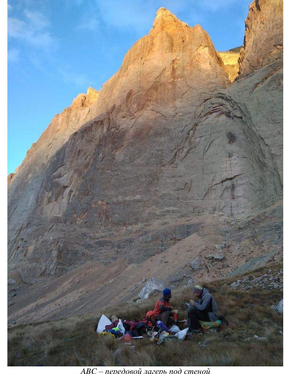
From the hut, go downstream along the valley to the bridge on the right and cross the Chehychay River. Then, via a bridge on the left, cross the Sel'dy River and follow the road, bypassing a farm on the right, along the Erydag massif. Turn right from the road and go up the hills to the left towards the Wall. Traverse along the slope (to the NE) and, veering right (closer to the wall), move along the grassy slopes towards the "Well," traversing the zone of gullies and clay couloirs. ABC (Advanced Base Camp) is located 200 m from the wall, opposite the "Big Well." From ABC, descend into the gully of the stream flowing from the "Well," traversing the scree slope towards the wall. Water can be collected in the stream. Climb out of the gully and move left and up towards the start of K. Dorro's route, 2005.
The approach to the start of the route takes about 35–45 minutes with heavy backpacks.
Shanovazov's route, 2005, category 6B, passes between the routes of Goloshchapov and Voronin in a straight line through smooth slabs and a cornice belt to the internal angle. The "Direct" wall is the most direct and most challenging route. The routes of Goloshchapov and Voronin deviate from the straight line to the left and right, mainly following the natural relief.
Under favorable weather conditions, the route is relatively safe regarding rockfall.
The main issue on the route is water; there is none, and in winter, there is neither snow nor ice on the wall. Therefore, the entire necessary water supply must be carried in plastic bottles.
The route includes sections of "booming" slabs that require special attention. Particularly problematic sections are the cornice belt, with rope lengths of about 15–20 m. In addition to the large cornice, there are 5 more cornice sections of 2–3 m. Furthermore, throughout the first bastion, there are many sections of vertical and slightly overhanging smooth slabs where skyhooks and bolts are the primary means of movement.
On these sections, the terrain is extremely unreliable; the rock is crumbling and flaking. Cracks are blind and filled with calcite. Descent from the wall while passing the cornice is impossible.
During the wall ascent, the entire arsenal of wall climbing equipment for artificial technical aids (ITOs) was used, including camalots, friends, anchors (all types: medium, small, with a bend), fifas, skyhooks (bottle-shaped and relief), and talons. Bolts: removable, ears with nuts and washers for pins, and ears for spits.
Backpacks were transported under the harness and by pulling with the help of minitrekshins. There were 3 backpacks in total, with a starting weight of about 35–40 kg each. 42 liters of water were taken on the route. 8 liters remained by the time we reached the summit plateau.
The first climber worked, belaying with one dynamic rope and installing a static rope as a handrail for the second. The second followed along the handrail on jumars, belayed by the first with a dynamic rope. The second also pulled the static and dynamic ropes for the third and carried a relatively light backpack from the platform.
When the first climber moved far enough from the station, the second, simultaneously with belaying the first through a Grigrigri, began to belay the third with a top rope through a minitrekshin. The third started moving on jumars towards the second along the handrail made of static rope, belaying with a dynamic rope. The third also pulled two heavy backpacks, mostly in 2 hauls.
Overnight stays were organized using a collapsible three-person platform (according to the manufacturer, not the climbers), which was disassembled from above every morning, packed into a backpack, and reassembled every evening at a new location. Inside, a single wide, continuous caramat (1×2 m) — a piece of thermal insulation from a hardware store — was laid out. Climbers slept "valet-style," covered with two stitched sleeping bags. The weather during the ascent was mostly good, except for the second day, when hurricane-force winds literally blew the first climber off the skyhooks, and rain with snow soaked everything.
At night, a cold, strong wind always blew, shaking the tent and penetrating through its fabric.
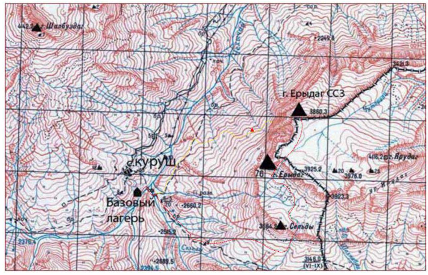
Area map:
- Yellow line — path to the wall;
- Red triangle — ABC;
- Red line — descent path via 1B, bypassing v. Sel'dy.

Scheme of the Chehychay River gorge. Overnight stays: 1 — "Kurushskie" (also Leonov's hut), 2 — "Shalbuzdagskie", 3 — "Upper Shalbuzdagskie", 4 — "Grot", 5 — "Sel'dy", 6 — "Erydagskie", 7 — "Big Stone", 8 — "Bazardyuzi", 9 — "Vakhchagskie".
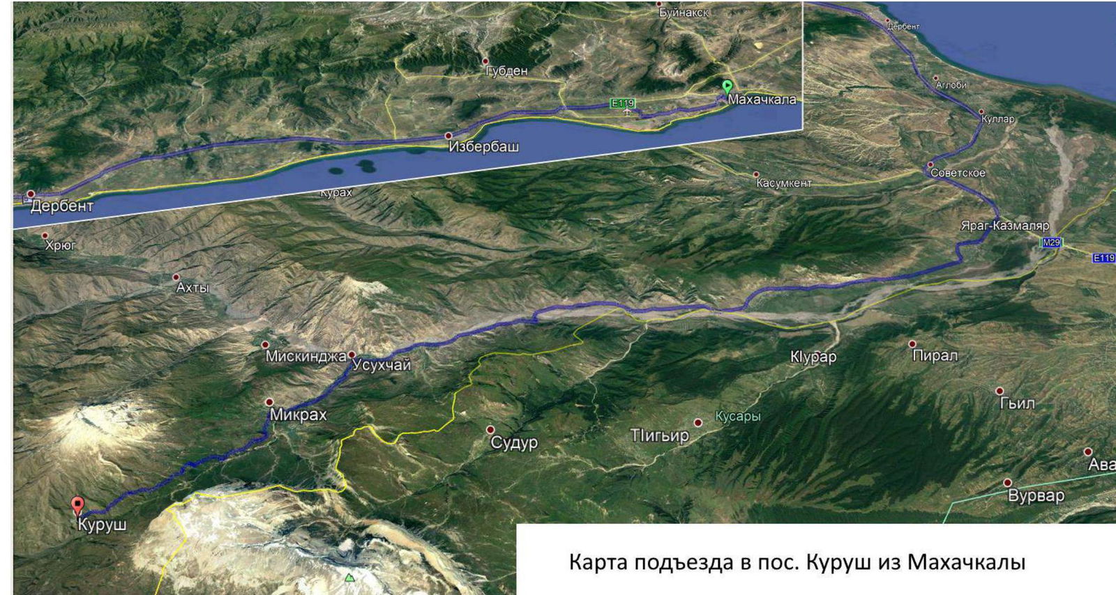
Map of the approach to Kurush village from Makhachkala
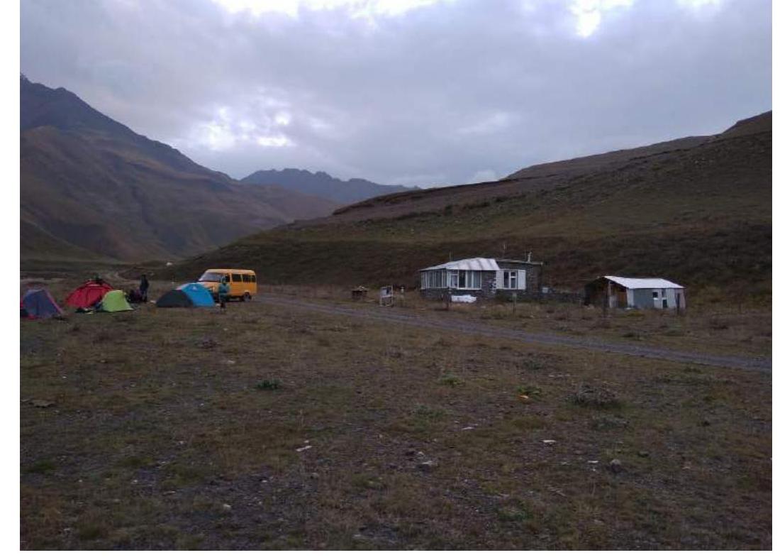
Base camp – Leonov's hut
ABC – forward camp under the wall
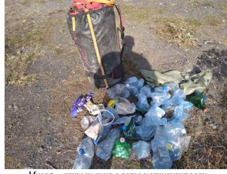
Garbage — taken down from the mountain and disposed of
Tactical actions of the team
In early October 2018, the Alpinism and Rock Climbing Federation of Arkhangelsk Region organized an ascent to peak Erydag NW via Shanovazov's route, category 6B.
The team consisted of:
- Two representatives from the assembled Arkhangelsk Region alpinism team;
- One representative from the Tatarstan Republic Alpinism Federation.
Ascent features:
- All participants were in the area for the first time;
- For all participants, this was the first ascent of category 6B.
On October 1, they arrived in Makhachkala, purchased some supplies, and registered with the Ministry of Emergency Situations. The head of the Dagestan Alpinism Federation, Petr G. Leonov, provided them with shelter for the night and comprehensive advice on the Erydag alpinism area.
On October 2, Petr G. Leonov organized a drop-off to the hut under the mountain. Along the way, they purchased the remaining supplies and gas. Upon arrival at the base, they packed their backpacks and spent the night in the hut.
On October 3, at 10:00, they moved under the wall and set up camp on the orographic left bank of the stream flowing from the "Well."
Ascent
Day 1. October 4, 2018
- 04:30 — Wake-up
- 07:30 — Started working on the route
- 16:40 — Finished working
Overnight stay on R4. Worked on until R5. Weather was good during the day. Strong wind at night, snow.
Day 2. October 5, 2018
- 04:30 — Wake-up
- 07:20 — Started working
- 16:15 — Passed the 1st control point
- 17:00 — Finished working
Overnight stay on R7. Worked on until R8.
Weather:
- Morning and day: snow with rain, strong wind
- Gusts of wind with precipitation significantly slowed movement on skyhooks over poor terrain
- Night: strong wind with snow
Day 3. October 6, 2018
- 04:30 — Wake-up
- 07:00 — Started working
- 15:45 — First climber passed the big cornice
- 17:10 — Finished working
Overnight stay on R12. Worked 10 m above. Weather was good.
Day 4. October 7, 2018
- 04:45 — Wake-up
- 07:05 — Started working
- 13:10 — Passed the 2nd control point
- 17:05 — Finished working
Overnight stay on R16. Worked 15 m above. Weather was good.
Day 5. October 8, 2018
- 04:30 — Wake-up
- 06:50 — Started working
- 15:00 — First climber reached the ledge (R21)
- 16:40 — Finished working
Overnight stay on R23. Overnight stay was organized on a ledge where almost all routes to Erydag NW converge.
Day 6. October 9, 2018
- 04:45 — Wake-up
- 07:15 — Started working
- 13:30 — First climber reached the plateau
- 14:50 — Reached the summit
- 19:30 — Descent to the base camp, bypassing Sel'dy peak, via route 1B
The route was ascended in alpine style, without prior acclimatization. Since all participants had extensive high-altitude acclimatization during the summer season just before the ascent, the team decided not to conduct a preliminary acclimatization climb. A rotating scheme of movement was used during the ascent. All overnight stays were organized on platforms, which were moved to new locations every day. The starting water supply was 42 liters. The initial weight of gear and supplies was 3 backpacks of 35–40 kg each. All garbage accumulated during the ascent was taken down and disposed of.
The route is complex, lengthy, and labor-intensive — the most challenging for each team member. The wall's angle is very high: 80 °.
This route has many sections of difficult climbing, both psychologically and technically/physically challenging:
- VI climbing — 700 m
- V — 200 m
- A lot of ITO A2 and A3
Some protection points are unreliable:
- Anchor hooks hammered into blind cracks with just the tip or placed in cavities under stress
- Friends installed in open shells
- Many removable bolts were installed in very loose rock, which does not ensure their proper function
In the middle section, there is ITO on "booming" slabs.
We spent 5.5 days (56.35 hours) on this route.
A strong team from Krasnoyarsk Krai, consisting of A. Zhigalov, T. Ivanov, and M. Efremov, also climbed this route in 5.5 days (48.45 hours) in October 2017, and this ascent took 2nd place in the remote Russian Championship in the technical and high-altitude class.
A very strong team from Sverdlovsk Region, consisting of A. Klenov, M. Devi, S. Dashkevich, and M. Borich, during the on-site Russian Championship in the summer, climbed this route in 4 days (51 hours).
Based on the above, we believe that the route corresponds to category 6B.
Throughout our ascent, our release officer and observer, Petr G. Leonov (head of the Dagestan Alpinism Federation, Master of Sports, instructor 1st category), was in the hut, with whom we maintained contact throughout. With his help, we also coordinated with border services and the Ministry of Emergency Situations. Petr G. Leonov constantly observed us through binoculars and can confirm the accuracy of our report.
P.G. Leonov
Ascent graph to v. Erydag NW via Shanovazov's route 6B
UIAA Scheme
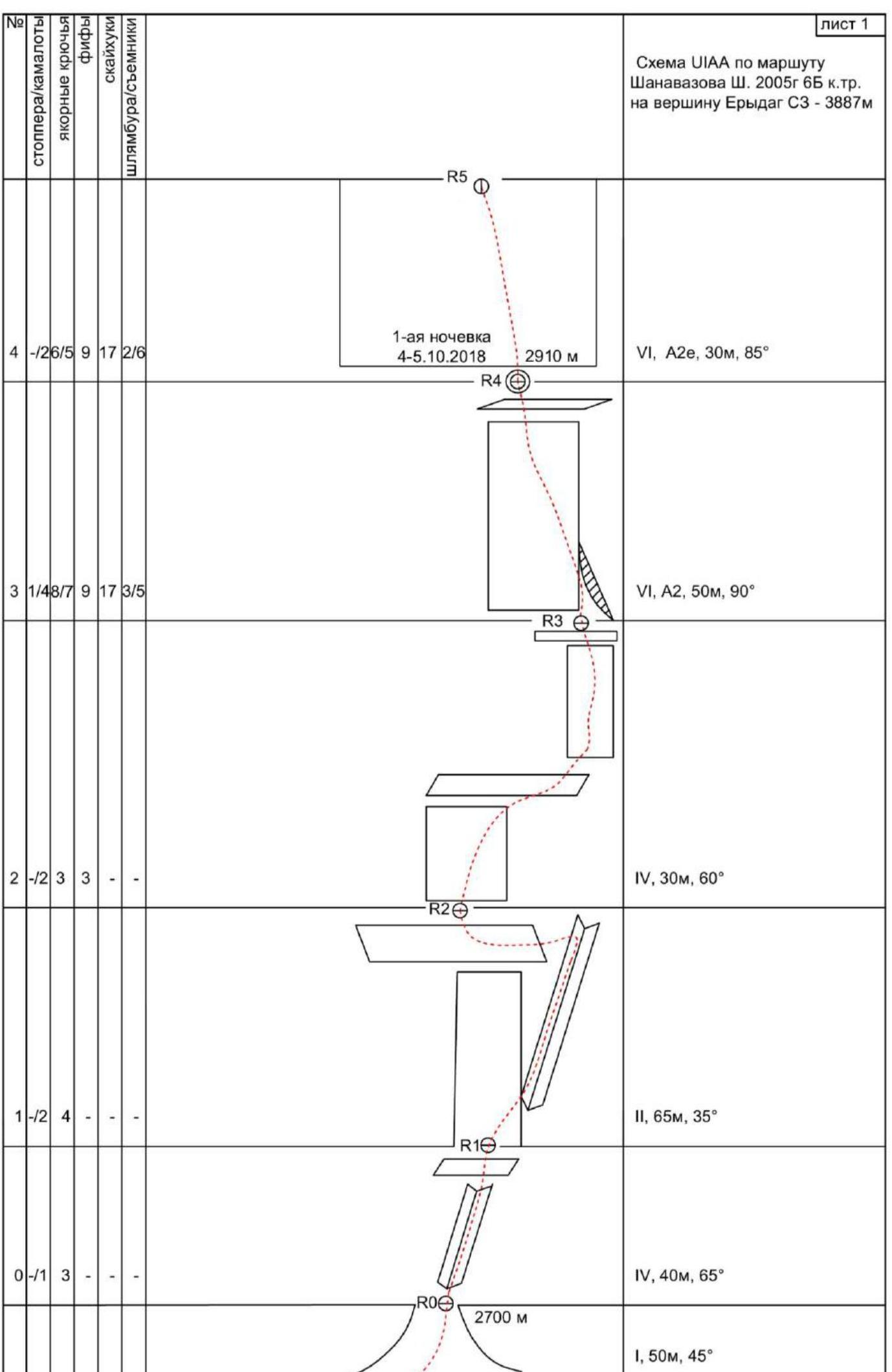
| № | Stoppers/camalots | Anchor hooks | Fifas | Skyhooks | Bolts/removables |
|---|---|---|---|---|---|
| 4 | -/26/5 | 9 | 17 | 2/6 | |
| 3 | 1/48/7 | 9 | 17 | 3/5 | |
| 2 | -/2 | 3 | 3 | - | |
| 1 | -/2 | 4 | - | - | |
| 0 | -/1 | 3 | - | - |
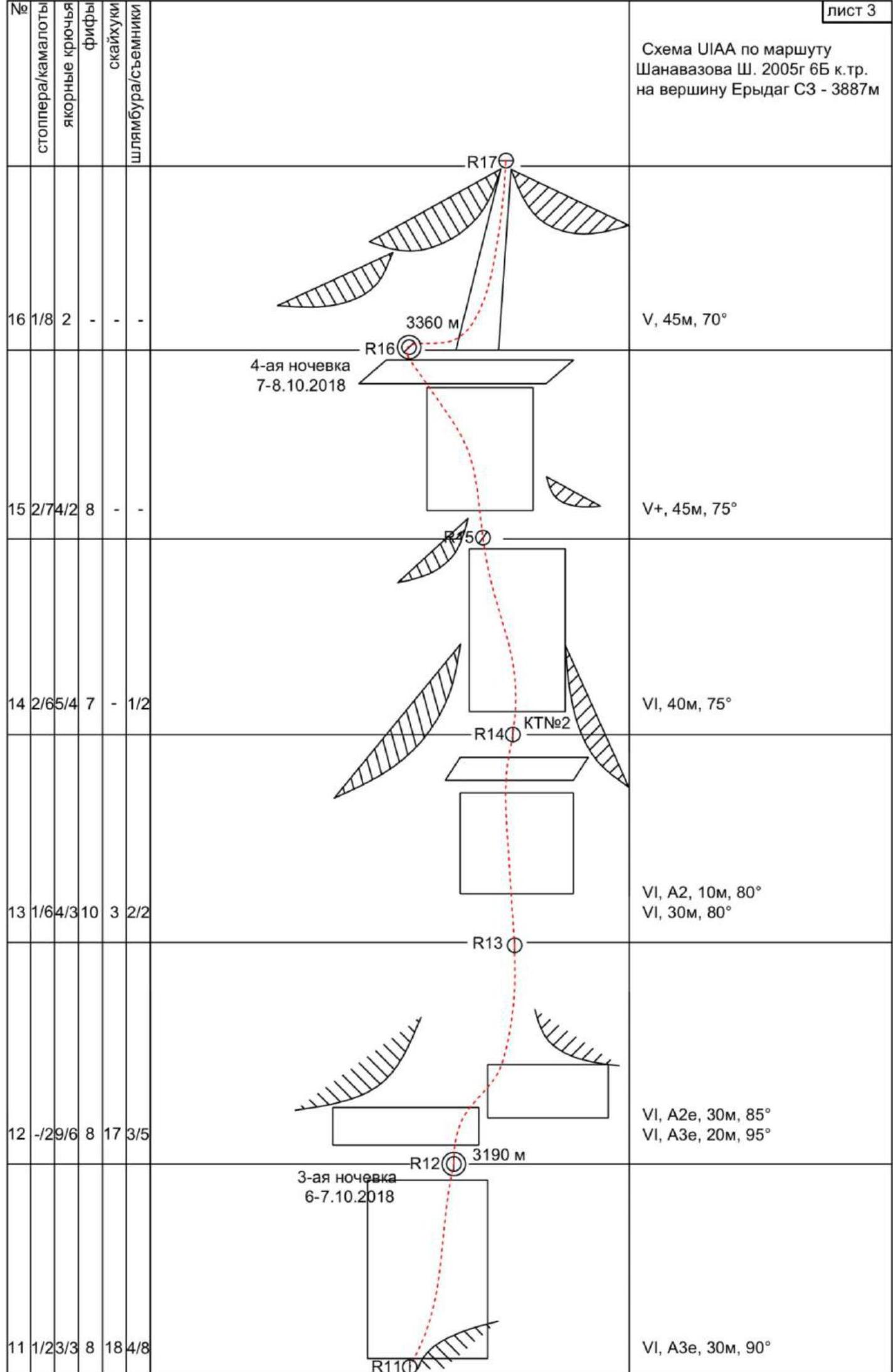
UIAA scheme for Shanovazov's route, 2005, 6B category, to the summit of Erydag NW — 3887 m
| № | Stoppers/camalots | Anchor hooks | Fifas | Skyhooks | Bolts/removables |
|---|---|---|---|---|---|
| 10 | -/28/8 | 6 | 16 | 4/6 | |
| 9 | 2/86/3 | 5 | 5 | -/1 | |
| 8 | 2/95/1 | 3 | - | -/3 | |
| 7 | 3/85/2 | 4 | 1 | ||
| 6 | -/96/2 | 6 | 6 | 3/4 | |
| 5 | 1/13/3 | 10 | 24 | 4/7 |
| № | Stoppers/camalots | Anchor hooks | Fifas | Skyhooks | Bolts/removables |
|---|---|---|---|---|---|
| 16 | 1/8 | 2 | - | - | |
| 15 | 2/74/2 | 8 | - | - | |
| 14 | 2/65/4 | 7 | 1/2 | ||
| 13 | 1/64/3 | 10 | 3 | 2/2 | |
| 12 | -/29/6 | 8 | 17 | 3/5 | |
| 11 | 1/23/3 | 8 | 18 | 4/8 |
| № | Stoppers/camalots | Anchor hooks | Fifas | Skyhooks | Bolts/removables |
|---|---|---|---|---|---|
| 24 | 2/75/5 | 5 | 1/- | ||
| 23 | 2/4 | 3 | 6 | 2/1/- | |
| 22 | - | - | - | - | |
| 21 | -/2 | - | - | - | |
| 20 | -/63/3 | 5 | 4 | 1/3 | |
| 19 | 1/45/5 | 2 | 5 | 2/3 | |
| 18 | 2/54/4 | 3 | -/2 | ||
| 17 | 2/8 | 6 | 4 | 1/1/- | |
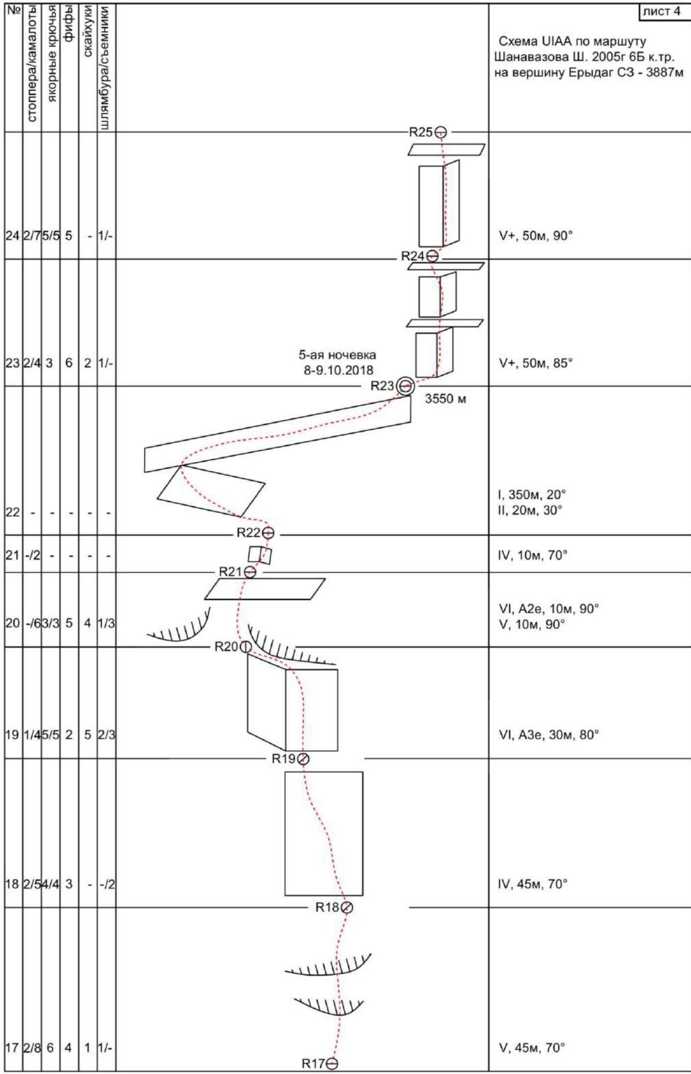
| Total | 25/123 | 116/71 | 126 | 137 | 33/57 |
| 28 | - | - | - | - | |
| 27 | -/54/3 | 4 | 1 | - | |
| 26 | - | - | - | - | |
| 25 | -/32/2 | 1 | - | 1/- |
UIAA scheme for Shanovazov's route, 2005, 6B category, to the summit of Erydag NW — 3887 m
Description by sections
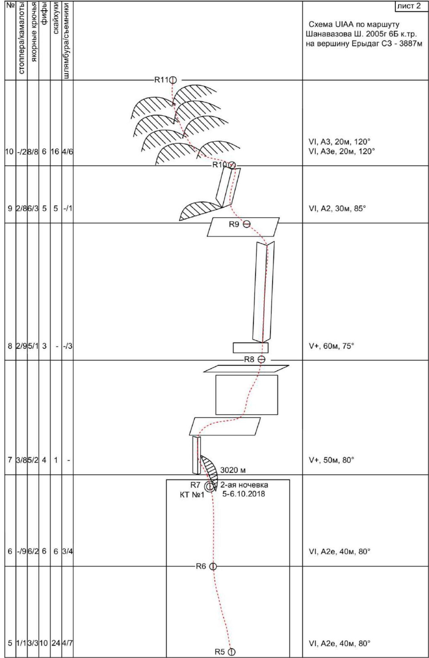
The start of the route is at the top of the scree, located to the left of Voronin's route. Section R0–R1. 40 m, 65 °, IV. Up the destroyed internal angle, generally upwards to the right. Station on a small ledge under the wall.
Section R1–R2. 65 m, 35 °, II. From the ledge, rightwards along a vaguely defined internal angle, bypassing the wall, to a wide ledge with stones. Along the ledge, traverse left under the monolithic wall.
Section R2–R3. 30 m, 60 °, IV. Up the wall with cracks, climbing in the direction of a bolt with a loop under the cornice — R3. Station on a comfortable ledge under the cornice.
Section R3–R4. 50 m, 90 °, VI, A2e. Up slightly left along the crack under the cornice, then slightly right and up, mainly on skyhooks and removable bolts, to an inclined scree ledge. Station on bolts and removables. The first overnight stay was organized on R4, on a platform.
Sections R4–R6. 70 m, 80°–85 °, VI, A2e. Up the wall on holey and relief skyhooks. General direction left and up under the oblique cornice — the brow. Do not go right along the destroyed terrain! The terrain is extremely poor. Sometimes there are cavities and cracks where friends, camalots, or anchors can be placed for protection. Stations are hanging and uncomfortable.
Section R6–R7. 40 m, 80 °, VI, A2e.
- From the hanging station on 3 bolts, slightly down and left.
- Do not go too far left; you can end up on the "ram's foreheads"!
- Then upwards under the overhang. Be careful! The rock of the overhangs is so destroyed that it is set in motion by a loaded friend used as a protection point!
- R7 has the first control point.
- Overnight stay №2.
Section R7–R8. 50 m, 80 °, V. The cornice — brow — is bypassed on the left, then along the internal angle to the right, climbing with elements of ITO, to a ledge.
Section R8–R9. 60 m, 75 °, V+. Up the wall to the base of the internal angle. Up the angle to a large ledge. Protection is reliable — friends, camalots, anchors.
Section R9–R10. 30 m, 85 °, VI, A2. Up through cracks between the "booming slabs." The left landmark is a large flake.
The rock is extremely unreliable:
- Large crumbling blocks
- "Living stones"
The station is uncomfortable, hanging, on bolts under a large cornice.
Section R10–R11. 40 m, 120 °, VI, A3. The big cornice is passed along a series of cracks and gentle slopes on anchors, skyhooks, and removable bolts. General direction left and up. Rarely, equipment left by previous climbers is encountered. The station is hanging, on bolts. This section can be divided into two of 20 m each.