ASCENT PASSPORT
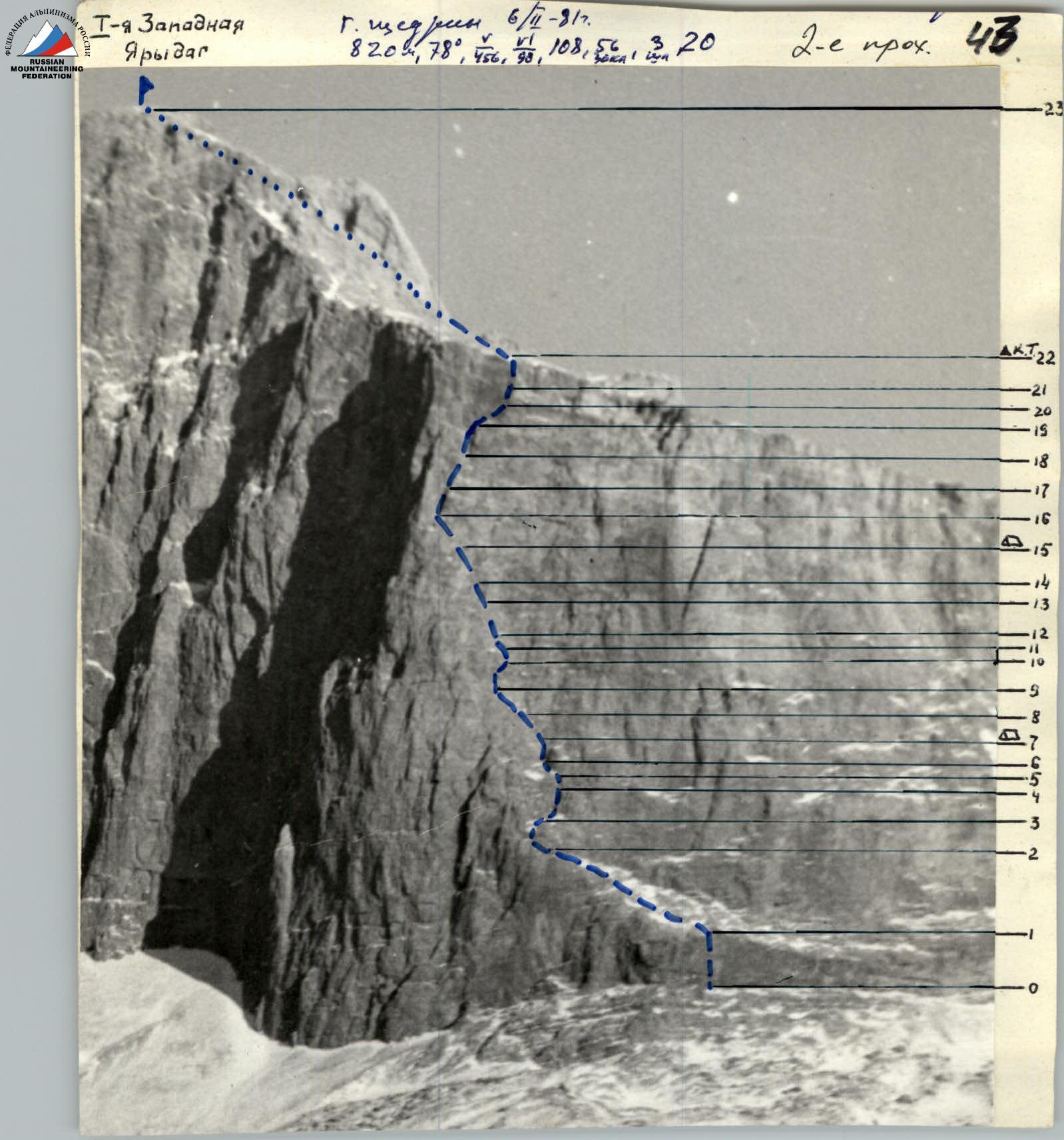
I. Ascent class: rock 2. Ascent area, ridge: East Caucasus 3. Summit, its height, ascent route: I-ya Zapadnaya Yarydag via left edge of Western wall (Polyakov's route) 4200 m 3rd ascent. 4. Proposed difficulty category: 5B 5. Route characteristics: height difference 820 m Length of sections with 5–6 difficulty category 456 m, 6 difficulty category — 90 m, average steepness 78°. 6. Pitons used: for belaying: chocks 56, rock 108, ice 0, bolt 3. for creating artificial anchors: rock — IX, ice — 0, bolt — 0. 7. Number of climbing hours: 20 hours on the wall, 2 hours on the plateau. 8. Number and characteristics of bivouacs: 2 (first joint sitting, second joint sitting). 9. Surname, name, patronymic of the leader, participants and their qualification: Leader: Shchedrin G.S. Master of Sports of the USSR. Participants: Moshnikov A.I. Master of Sports of the USSR, Andreev V.I. Candidate for Master of Sports, Parshin V.S. Candidate for Master of Sports, Trofimov D.A. Candidate for Master of Sports. 10. Team coach: Troshchinenko L.A. Master of Sports of the USSR. II. Dates of departure and return:
- February 6–8, 1981 at 8:00 — departure from the base camp at Kurush.
- February 8, 1981 at 20:00 — return to the base camp.
TABLE OF MAIN CHARACTERISTICS OF THE ASCENT ROUTE
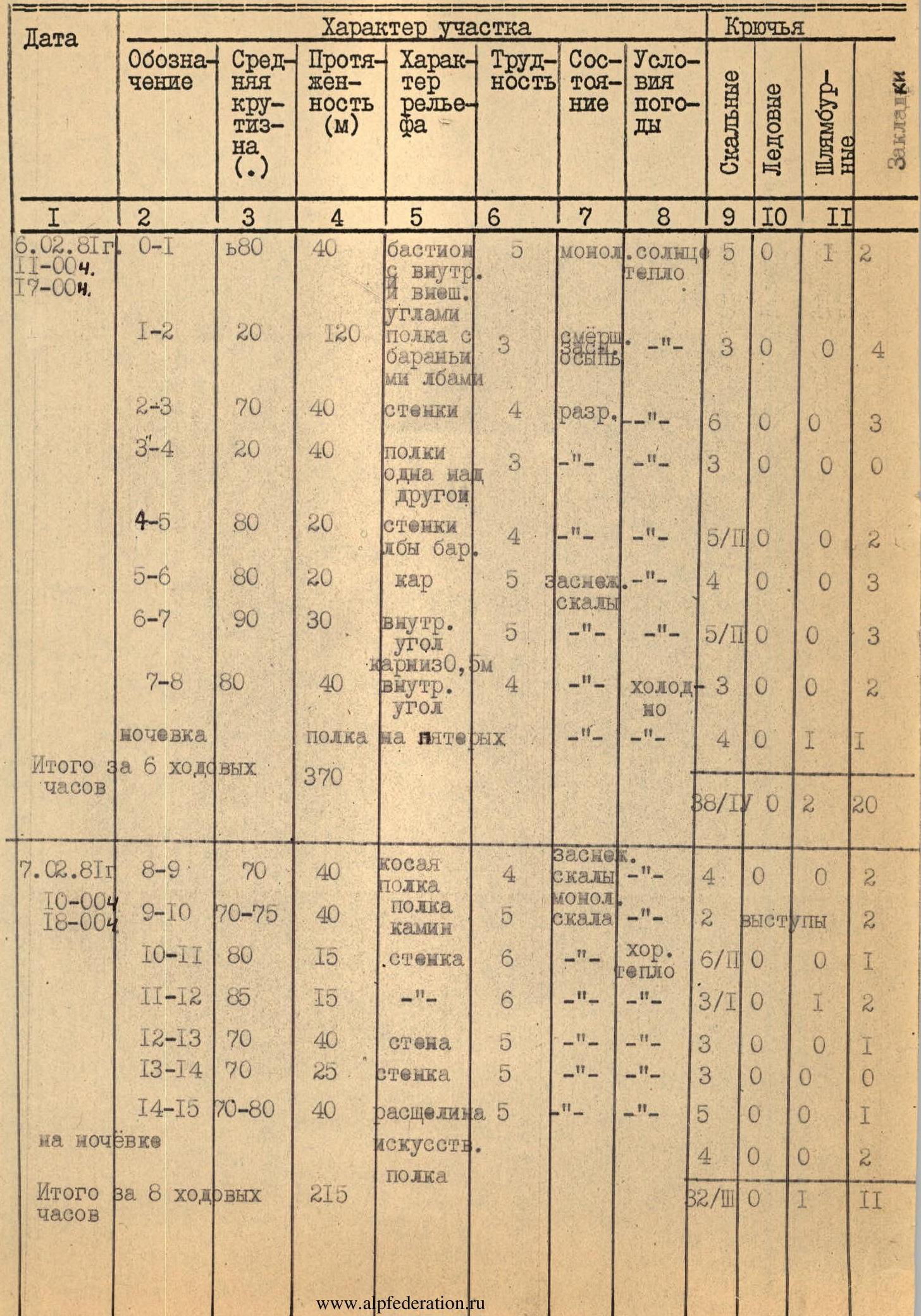
| Date | Designation | Average steepness (°) | Length (m) | Section characteristics | Difficulty | Condition | Weather conditions | Pitons (rock) | Pitons (ice) | Pitons (bolt) | Chocks |
|---|---|---|---|---|---|---|---|---|---|---|---|
| February 6, 1981 | R0–R1 | 68 | 40 | bastion with inner and outer corners | 5 | monolith | sun, warm | 5 | 0 | 1 | 2 |
| 11:00–17:00 | R1–R2 | 20 | 120 | shelf with "ram's foreheads" | 3 | snow | — | 3 | 0 | 0 | 4 |
| R2–R3 | 70 | 40 | walls | 4 | crumbly | — | 6 | 0 | 0 | 3 | |
| R3–R4 | 20 | 40 | shelves one above another | 3 | — | — | 3 | 0 | 0 | 0 | |
| R4–R5 | 80 | 20 | walls, "ram's foreheads" | 4 | — | — | 5/II | 0 | 0 | 2 | |
| R5–R6 | 80 | 20 | cornice | 5 | snowy rocks | — | 4 | 0 | 0 | 3 | |
| R6–R7 | 90 | 30 | inner corner, 0.5 m cornice | 5 | — | — | 5/II | 0 | 0 | 3 | |
| R7–R8 | 80 | 40 | inner corner | 4 | — | cold | 3 | 0 | 0 | 2 | |
| Bivouac | shelf for five | 4 | 1 | 1 | |||||||
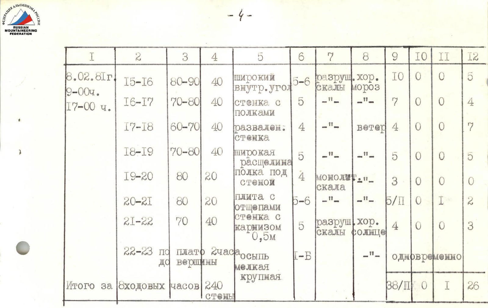
| Total for 6 climbing hours | 370 | 88/I | 0 | 2 | 20 | ||||||
| February 7, 1981 | R8–R9 | 70 | 40 | oblique shelf | 4 | snowy rocks | — | 4 | 0 | 0 | 2 |
| 18:00–10:00 | R9–R10 | 70–75 | 40 | shelf, chimney | 5 | monolith, rock | — | 2 | ledges | 2 | |
| R10–R11 | 80 | 15 | wall | 6 | — | good, warm | 6/I | 0 | 0 | 1 | |
| R11–R12 | 85 | 15 | — | 6 | — | — | 3/I | 0 | 1 | 2 | |
| R12–R13 | 70 | 40 | wall | 5 | — | — | 3 | 0 | 0 | 1 | |
| R13–R14 | 70 | 25 | wall | 5 | — | — | 3 | 0 | 0 | 0 | |
| R14–R15 | 70–80 | 40 | crack | 5 | — | — | 5 | 0 | 0 | 1 | |
| At bivouac | artificial shelf | 4 | 0 | 0 | 2 | ||||||
| Total for 8 climbing hours | 215 | 32/I | 0 | 1 | 11 |
Total wall length 820 m. Total 22 climbing hours (20 hours on the wall, 2 hours on the plateau).
Brief explanation of the table
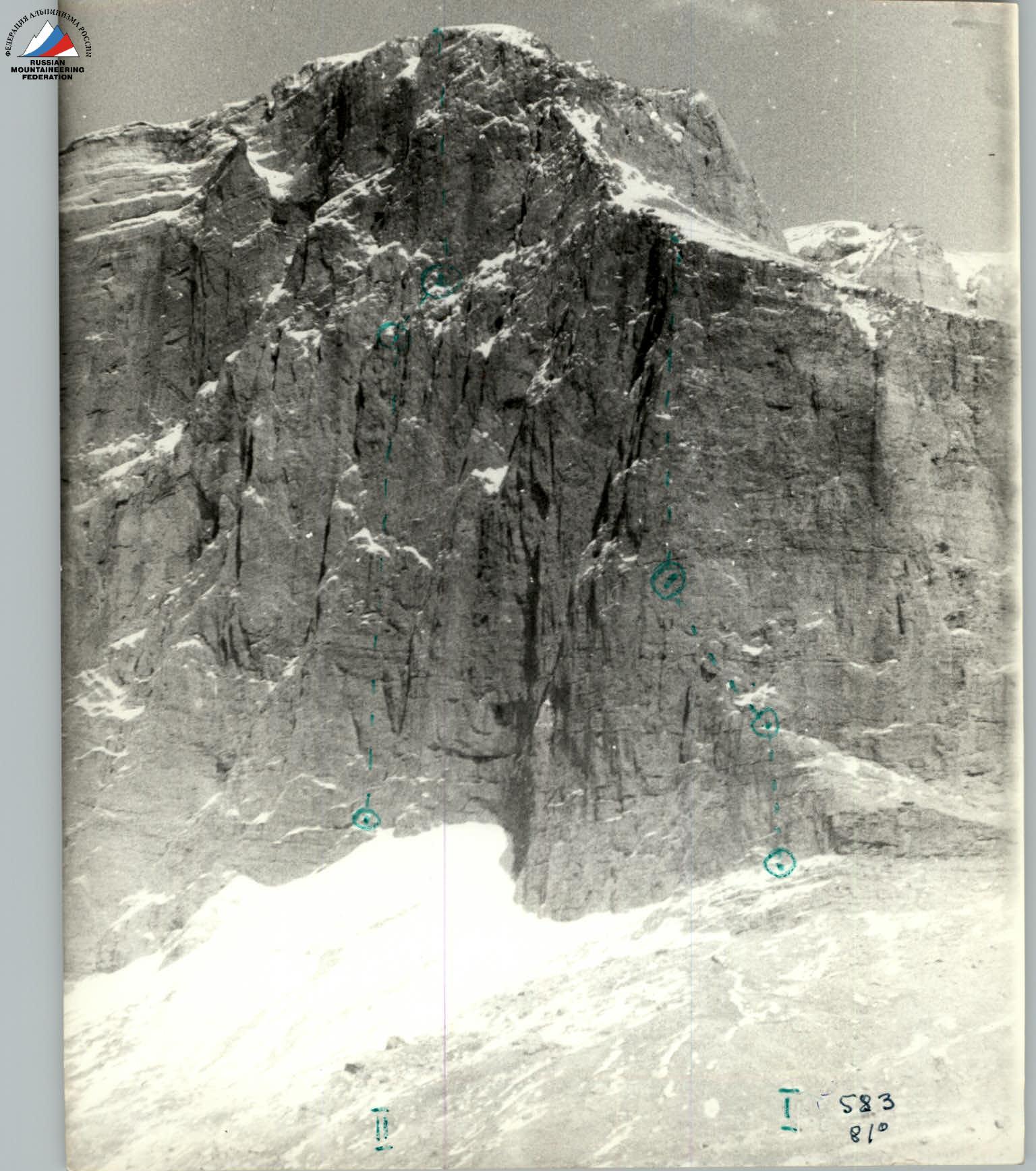
R0–R1. Start of the route from the control post, at the base of the bastion, built by the first ascenders. Movement is vertically upwards along clearly defined external and internal steep corners, leading to a large shelf. The rocks are monolithic, with many cracks for driving pitons. R1–R2. Simultaneous movement along a large 120 m shelf to the left edge of the western wall with a slight gain in height. R2–R3. Climb upwards along small, crumbling walls and "ram's foreheads" with an exit under a small shelf, going from left to right. R3–R4. Along simple rocks, upwards to the left — exit to a shelf and then along it to the right. Many loose rocks. R4–R5. Along small steep walls and "ram's foreheads" — exit under a cornice, which is clearly visible from afar in the lower half of the wall. Loose rocks are found, possible use of artificial footholds. R5–R6. Along snowy, difficult rocks — traverse to the left with a slight ascent to exit into the cornice. R6–R7. From the cornice, vertically upwards along an inner corner with a 0.5 m cornice. Climbing is very difficult. Requires the use of ladders and slings. Exit to a shelf, in the right part of which is a joint sitting bivouac for five after an hour of snow trampling. Cramped and cold, especially in the morning. R7–R8. From the evening of the previous day, one rope was processed along a wide inner corner, with small crumbling walls, "ram's foreheads," and shelves. Exit to an oblique shelf, going upwards to the left. Climbing is complicated by snow on the rocks and low temperature. R8–R9. At 10:00 — start of work by the first climber, upwards to the left along an oblique shelf, leading to the edge of the wall. Rocks are snowy, monolithic. R9–R10. Along the shelf — descent 3 m down to the base of an 8 m chimney, leading under a 30 m steep wall. Cold, few handholds and cracks, there are ledges for belaying. R10–R11. Key point of the route — climbing of extreme complexity with the use of artificial footholds. Movement along the wall — traverse to the right with ascent upwards.
Total wall length 820 m. Total 22 climbing hours (20 hours on the wall, 2 hours on the plateau).
R11–R12. Steepness of the wall increases, movement first to the right, then upwards to the left. Few cracks, climbing is also of extreme complexity. R12–R13. Steepness of the wall decreases, movement first to the right, then upwards to the left. Sufficient number of handholds, rock is monolithic. R13–R14. Along a small wall to the right to the base of a wide inner corner. Climbing is complex, few cracks for pitons. R14–R15. Straight up along a crack to the base of a wide inner corner. A small sitting bivouac for a group of 5 people is set up. R15–R16. From the evening of the previous day, one rope was processed along a very difficult climb along the same inner corner with a crack and small walls. Many loose rocks. R16–R17. Movement along the same inner corner with walls and shelves, leading to a rugged terrain. Cold, wind, 9:00 am. R17–R18. Rugged small walls, leading to a crack. Climbing is of average difficulty. Many loose rocks. R18–R19. Wide crack, leading under the upper inner corner and wall with black stains, ending on the plateau. Cold, no sun, climbing is difficult, many cracks for chocks. R19–R20. Easy traverse to the right under the wall with black stains to a slab detached from the main wall. R20–R21. Upwards along a slab with flakes, very difficult climbing. Limited number of handholds and places for driving pitons. Use of a bolt and ladders to exit to a shelf. R21–R22. From the shelf with a bolt to the right — traverse around the corner. Then along a slightly overhanging chimney with a 0.5 m cornice to a dissected wall, leading to the plateau, control post. R22–R23. Along snowy scree for 2 hours to the summit of I-ya Zapadnaya Yarydag. The path to the summit is along a wide gully to the left of it.
Recommendations for subsequent climbers
- Descent from the summit via route 1B category.
- Passage of the route in more favorable weather and lighting conditions is possible with one bivouac.
- Pay special attention to sections with a large number of loose rocks and crumbling rocks.
Schematic representation of the wall section of the route according to the UIAA system:
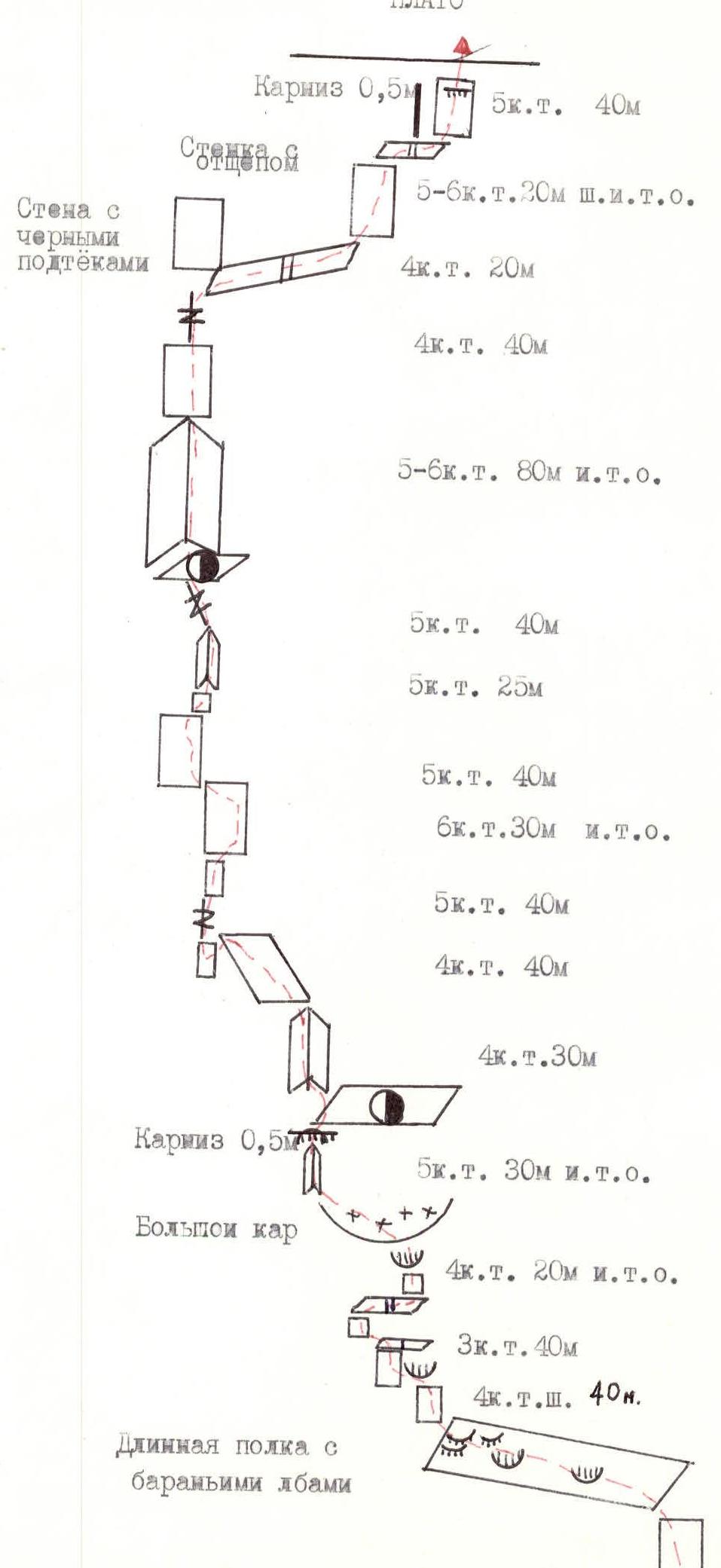
- PLATEAU
- 0.5 m cornice
- 5th category, 40 m
- Wall with a flake
- 5–6th category, 20 m with artificial anchors
- Wall with black stains
- 4th category, 20 m
- 4th category, 40 m
- 5–6th category, 80 m with artificial anchors
- 5th category, 40 m
- 5th category, 25 m
- 5th category, 40 m
- 6th category, 30 m with artificial anchors
- 5th category, 40 m
- 4th category, 40 m
- 4th category, 30 m
- 0.5 m cornice
- 5th category, 30 m with artificial anchors
- Large cornice
- 4th category, 20 m with artificial anchors
- 3rd category, 40 m
- 4th category with artificial anchors, 40 m
- Long shelf with "ram's foreheads"
- 3rd category, 120 m
- 5th category, 40 m
Tactical actions of the team
The route to Yerydag summit via the left edge of the Western wall, first ascended by A. Polyakov, is a very complex route along a wall of great steepness. The rocks consist of iced limestone, alternating with layers of sandstone. Visually, the route appears to be a monolithic rock without clear dissection. The team's tactical actions were based on a tactical plan drawn up before the ascent. This plan was based on information obtained from reports by Leningrad climbers who first ascended this variant of Polyakov's route in May 1987, and oral recommendations from Donetsk climbers. The team's high technical and physical preparation was also taken into account. All team members have Candidate for Master of Sports qualification in rock climbing, and one has Master of Sports; two have Master of Sports in mountaineering. Team members have made more than ten ascents of 5B category in the current season. Equipment with mountaineering gear.


| Bolt | Bolt (ice) | Chocks | Section | Category | Meters | Steepness (°) |
|---|---|---|---|---|---|---|
| 3 | R14 | V+ | 10 | 95 | ||
| 3 | 9 | R13 | IV | 80 | 65 | |
| 1 | 4 | R12 | IV | 30 | 75 | |
| 2 | 3 | R11 | IV | 45 | 60 | |
| 4 | R10 | V | 20 | 90 | ||
| 2 | 2 | R9 | V | 20 | 75 | |
| 3 | R8 | IV | 20 | 60 | ||
| 1 | 1 | R7 | VI | 5 | 95 | |
| 1 | R6 | VI | 10 | 90 | ||
| 2 | 6 | R5 | V | 40 | 75 | |
| 4 | R4 | IV | 20 | 70 | ||
| 2 | 1 | R3 | IV | 20 | 70 | |
| 2 | 7 | R2 | V | 45 | 75 | |
| 1 | 2 | R1 | V | 15 | 75 | |
| 2 | 6 | R0 | V+ | 45 | 90 |
YERYDAG SUMMIT
Climbing hours: 12 hours 45 minutes. Route length: 2165 m. Height difference: 1100 m.
| Bolt | Bolt (ice) | Chocks | Section | Category | Meters | Steepness (°) |
|---|---|---|---|---|---|---|
| 41 | 4 | 108 | R31 | I | 1300 | 15 |
| R30 | V | 15 | 65 | |||
| 2 | 1 | 3 | R29 | VI | 30 | 90 |
| 1 | 3 | R28 | V | 20 | 85 | |
| 1 | 3 | R27 | IV | 20 | 60 | |
| 2 | R26 | V | 10 | 75 | ||
| 2 | 6 | R25 | V | 45 | 80 | |
| 2 | 4 | R24 | IV | 40 | 50 | |
| 5 | R23 | IV | 40 | 60 | ||
| 5 | 3 | R22 | V | 40 | 75 | |
| 4 | 4 | R21 | V | 40 | 75 | |
| 3 | 5 | R20 | V+ | 40 | 90 | |
| 3 | R19 | V | 15 | 85 | ||
| 2 | 6 | R18 | IV | 40 | 75 | |
| 2 | R17 | IV | 15 | 60 | ||
| 1 | 3 | R16 | V | 20 | 80 | |
| 1 | R15 | IV | 10 | 75 |