
ASCENT DOCUMENT
-
Ascent (traverse) class
-
Ascent area
-
Peak, height, ascent route
Combined, # 2.9 (East Caucasus), 4116 Bochek/4040/S. Gadzhieva/3812, traverse from the southwest.
-
Proposed difficulty category 3B
-
Route characteristics
Elevation gain 1100 m, length of sections: — 1st difficulty level — 2150 m; — 2nd difficulty level — 750 m; — 3rd difficulty level — 350 m; — 4th difficulty level — 200 m.
-
Number of pitons driven rock: 6 ice: 15 bolt: —
-
Number of travel hours 13
-
Number of overnight stays and their characteristics no overnight stays
-
Surname, first name, patronymic of the leader and participants and their sports qualification
- Leonov Petr Georgievich — II sports category
- Krasnopolsky Yuri Vasilyevich — CMS
- Semenova Marina Mikhailovna — II sports category
- Sogokon Alexander — II sports category
- Slobodenyuk Yuri — II sports category
-
Team coach Timoshin Mikhail Egorovich
-
Date of departure and return October 6, 1981

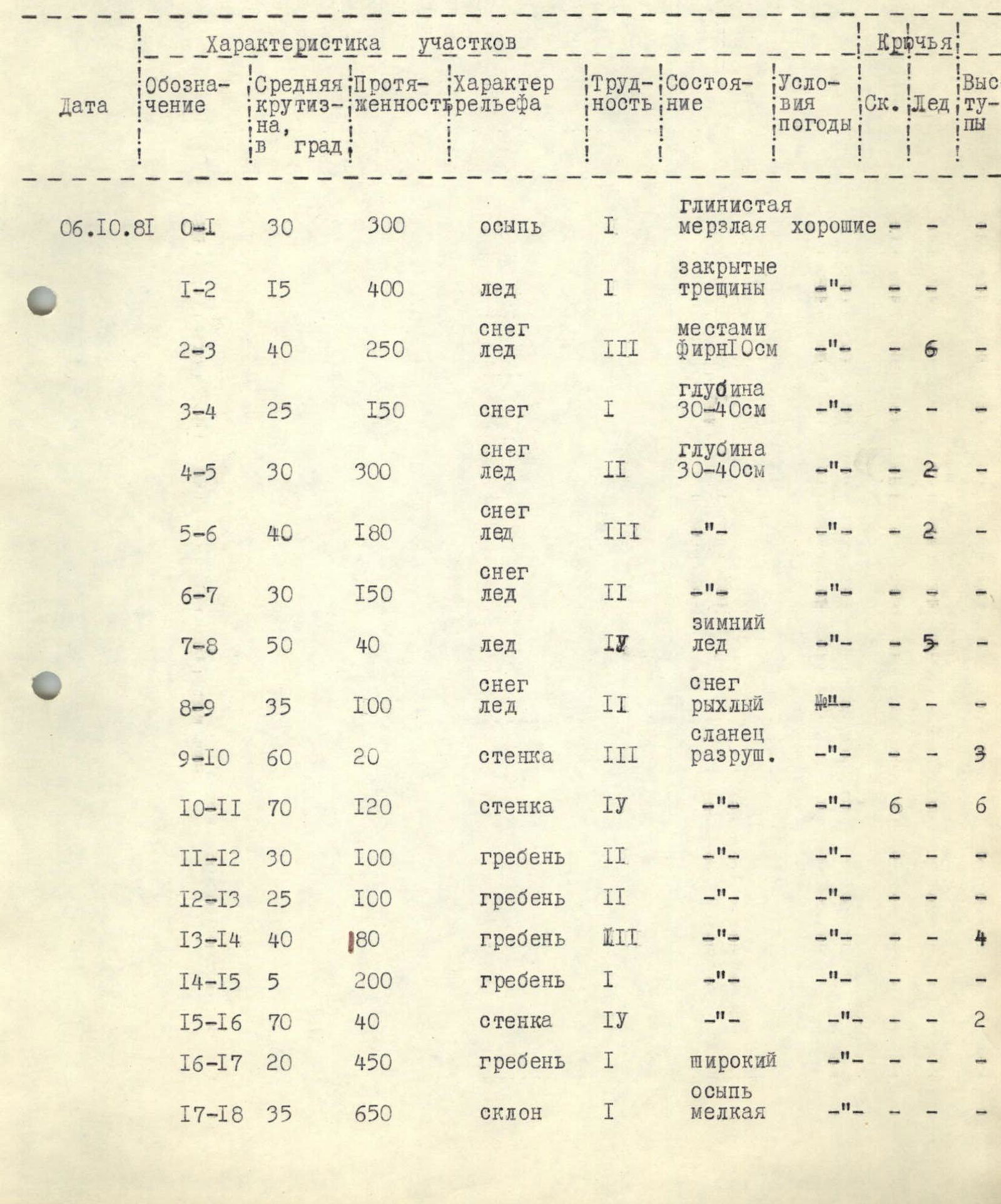
Table of main route characteristics

| Date | Designation | Average steepness, in degrees | Length, m | Terrain characteristics | Difficulty | Condition | Weather conditions | Pitons: Rock | Ice | Bolt |
|---|---|---|---|---|---|---|---|---|---|---|
| 6.10.1981 | R0–R1 | 30 | 300 | talus | 1 | clay permafrost | good | – | – | – |
| R1–R2 | 15 | 400 | ice | 1 | closed crevasses | – | – | – | – | |
| R2–R3 | 40 | 250 | snow, ice | 3 | partly névé, talus | – | – | 6 | – | |
| R3–R4 | 25 | 150 | snow | 1 | depth 30–40 cm | – | – | – | – | |
| R4–R5 | 30 | 300 | snow, ice | 2 | depth 30–40 cm | – | – | 2 | – | |
| R5–R6 | 40 | 180 | snow, ice | 3 | – | – | – | 2 | – | |
| R6–R7 | 30 | 150 | snow, ice | 2 | – | – | – | – | – | |
| R7–R8 | 50 | 40 | ice | 4 | winter ice | – | – | 5 | – | |
| R8–R9 | 35 | 100 | snow, ice | 2 | snow loose | – | – | 1 | – | |
| R9–R10 | 60 | 20 | wall | 3 | shale destroyed | – | – | – | 3 | |
| R10–R11 | 70 | 120 | wall | 4 | – | – | 6 | – | 6 | |
| R11–R12 | 30 | 100 | ridge | 2 | – | – | – | – | – | |
| R12–R13 | 25 | 100 | ridge | 2 | – | – | – | – | – | |
| R13–R14 | 40 | 180 | ridge | 3 | – | – | – | – | 4 | |
| R14–R15 | 5 | 200 | ridge | 1 | – | – | – | – | – | |
| R15–R16 | 70 | 40 | wall | 4 | – | – | – | – | 2 | |
| R16–R17 | 20 | 450 | ridge | 1 | wide | – | – | – | – | |
| R17–R18 | 35 | 650 | slope | 1 | talus small | – | – | – | – |
- p. 4040 (S. Gadzhieva)
Description of the approach to the traverse route V. Bochek — p. 4040 (S. Gadzhieva) — p. 3800, approximately 3B category complexity
From the village of Khonokh, Tsumadinsky district, DASSR, an automobile road goes up to the farm. Before reaching the farm, turn right, ford the river Khvarshi. Move along the well-trodden trail to the nomad camp (1.5 hours). Leaving the nomad camp below, continue along the right (in the direction of travel) side to the confluence of the rivers Bichuga and Tinav (elevation 2870 m). Here is a good platform. From the farm — 2–2.5 hours.
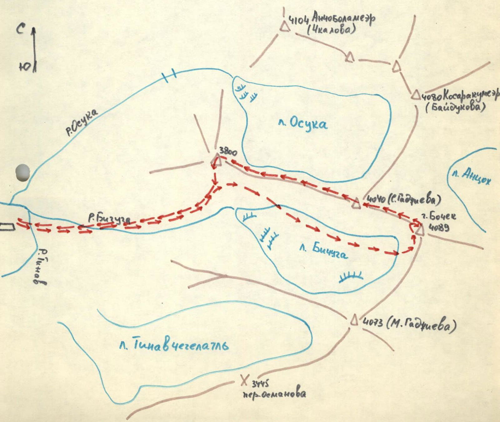
2. p. 4040 (S. Gadzhieva)
Description of the traverse V. Bochek — p. 4040 (S. Gadzhieva) — p. 3800
From the base camp at the confluence of the rivers Bichuga and Tinav, cross the river Tinav and move up along the river Bichuga. Before reaching the glacier tongue, turn left. Ascend a steep frozen talus (partly chopping steps) to the left side of the glacier. Bypassing a few crevasses, reach the foot of a steep ice-snow ascent. Move with protection in the direction of the col. Without reaching the col, turn left towards V. Bochek (from the base camp — 5 hours).
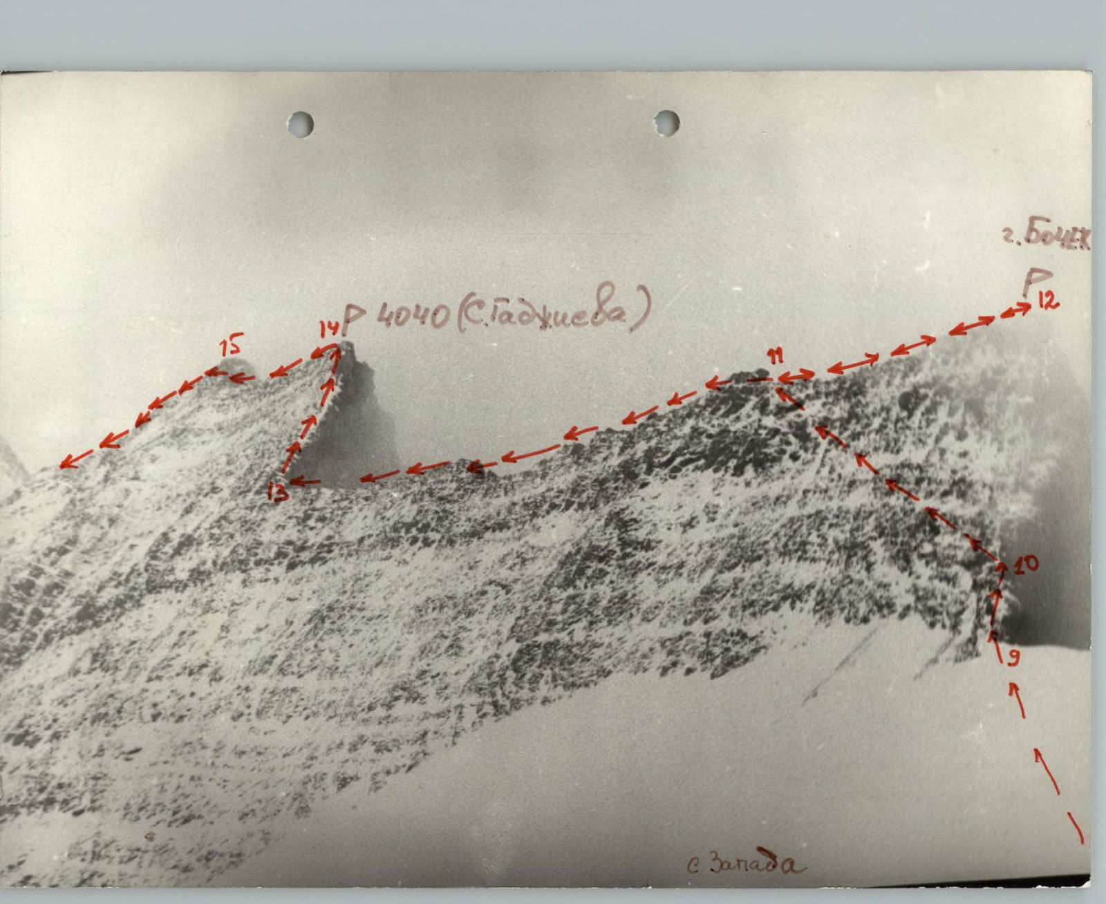
Straight up the destroyed rocks — 20 m. Further movement is hazardous. Here it is necessary: — traverse left along a steep shale wall (protection in places where sandstone outcrops); — reach the shoulder of V. Bochek (to the cairn). From the shoulder, ascend to the summit and return to the cairn. From the cairn, move straight down the ridge to the col between V. 4040 (S. Gadzhieva) and Bochek. Along the steep shale ridge of average difficulty, ascend to V. 4040 (S. Gadzhieva). On the summit — a cairn and a memorial plaque facing the valley of the river Khvarshi.
From the foot of the rock tower of V. Bochek — 4 hours. Along the traverse route, move along the ridge to the shoulder. From the shoulder: — a few meters left and down along a wide "branching" ridge to a shale wall; — a 40 m sport descent to a wide ridge; — along the ridge, first descent, then ascent — 160 m to V. 3800 (from V. 4040 (S. Gadzhieva) — 2 hours).
From the summit 3800, descend along a steep talus in the direction of the Bichuga glacier tongue, to the point where the ascent path joins the glacier. Then follow the ascent path back to the camp (from the summit 3800 — 2 hours).
Comments
Sign in to leave a comment