- Climbing Passport
- Climb category: technical
- Climbing area, ridge: № 2–9–а, Dagestan mountains, Greater Caucasus Range.
- Peak, its height, climbing route: Bazardyuzi, 4466 m, via the Eastern edge of the Northern ridge.
- Proposed category of difficulty: 4A category, combined.
- Route characteristics: а) elevation gain 1076 m. б) route length 1950 m, including: * category I 495 m. * category II 850 m. * category III 430 m. * category IV 140 m. * category V 35 m. в) average steepness: * Eastern edge — 44° * entire route — 37°
- Pitons driven:
- rock 13/2
- ice 0/0
- bolted 0/0
- protection gear 6/0
- Climbing hours: 16
- Number of nights and their characteristics: one bivouac.
- Full name of the leader, participants, and their qualifications:
- Smotrov Alexander Ivanovich — CMS
- Kudryavtsev Anatoly Ivanovich — 1st sports category
- Smotrov Sergey Ivanovich — CMS
- Khasnatulov Renat Magomedovich — 1st sports category
- Team coach: Krasnopolsky Yu.V. — CMS.
- Date of departure and return: November 5, 1985, 6:00 AM — departure from bivouac; November 6, 1985 — descent from the summit to base camp.
- Organization: KSS DASSR gathering.
Brief description of the approach to the route
From the village of Kurush, move southeast along the trail towards the Kurushsky pass. After crossing the bridge over the Chekhychay River, cross the next bridge over the Selda River and follow the trail along the left (here and further along the route) slopes of the Selda River. After approximately 1.5 km along the trail without significant ascent or descent, cross to the right slopes of the Selda River. A short steep ascent leads to a large terrace, which gently rises to the Northern ridge of Bazardyuzi peak. Here, without ascending to the Northern ridge, move between the Northern ridge and the lateral moraine of the Murkar glacier. At the confluence of the lateral moraine and the Eastern slope of the Northern ridge, there is a suitable "pocket" or depression. This is a convenient location for a storm camp, with good areas for tents and access to water.
From the village of Kurush, it takes 3–3.5 hours to reach this location. From the bivouac, move along the moraine to the cirque — towards the base of the Eastern edge, where the internal angle marks the beginning of the route. It takes 45–50 minutes from the bivouac to the route.
The route is a distinct edge descending eastward from the Northern ridge. On the left, the edge is bounded by a wide, steep, ice-and-snow couloir (photo 1, point 5). The left walls of the edge are monolithic and nearly vertical.
Photo 2A. Shooting point № Y on the Diagram. Distance — 1 km. Height = 3500 m. Lens "Industar-70" F=50 mm. June 6, 1985.
Photo 2. General view of the route. Shooting point № 2 on the Diagram. Distance to the object ≈ 2 km. Height ≈ 3000 m. Lens "Industar-70" F=50 mm. November 5, 1985.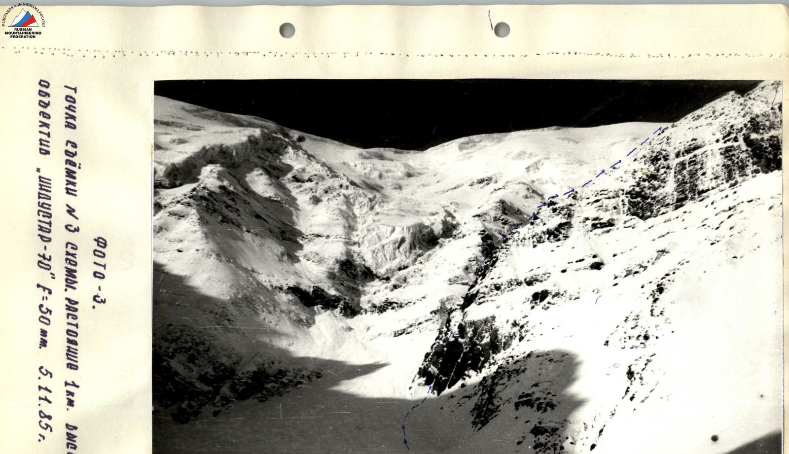
Photo 3. Shooting point № 3 on the Diagram. Distance 1 km. Height ≈ 3250 m. Lens "Industar-70" F=50 mm. November 5, 1985.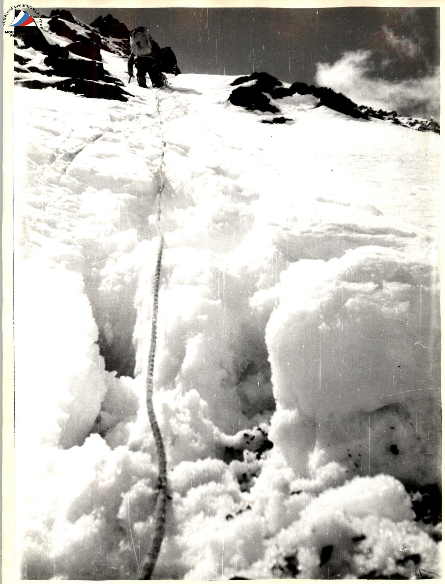
Brief explanation of the diagram
- R0–R1 (80 m, 67°, V): The beginning of the route from the control tour at the base of the 80-meter internal angle. Move straight up the internal angle. The rocks are monolithic. In the middle part of the angle, the rocks are fissured (shale), making it difficult to organize protection. In the upper third of the angle, there is a small (1.5 m) overhanging wall, which is heavily complicated by verglas. Use of artificial climbing techniques (I.T.O.) is required; climbing is challenging. At the end of the angle, there is a ledge for two people; the right side of the angle is monolithic, with cracks for pitons and protection gear.
- R1–R2 (20 m, 75°, V+): A 20-meter wall with increasing steepness. Climbing is challenging, with many loose rocks. Verglas is present.
- R2–R3 (20 m, 85°, V): A wall section.
- R3–R4 (5 m, 90°, A1 ITO): Ends with a 5-meter sheer wall and a 0.5-meter cornice. Climbing is challenging, using protection and I.T.O.
- R4–R5 (80 m, 55°, III): A steep, sharp, and broken ridge. Climbing is moderately difficult.
- R5–R6 (40 m, 65°, IV): Traverse along a rocky nose under the wall.
- R6–R7 (8 m, 85°, V): Ends with a steep 8-meter "gendarm" that is climbed directly. Climbing is above average difficulty.
- R7–R8 (200 m, 50°, III): A steep, broken ridge with negatively sloping rocks. Climbing is moderately difficult.
- R8–R9 (450 m, 30°, II+): The ridge becomes less steep and is also broken.
- R9–R10 (70 m, 10°, I): Progress is hindered by small "gendarms"; the ridge then becomes more gentle.
- R10–R11 (150 m, 45°, III): A broken ascent to the upper point of the Eastern edge and exit onto the Northern ridge. Climbing is moderately difficult, with many steep, small walls, some of which are bypassed, and some climbed directly.
- R11–R12 (400 m, 21°, I+): A not very steep but very sharp and broken Northern ridge leading to a saddle. Here, a bivouac is possible. A tent can be set up.
- R12–R13 (425 m, 20°, I): A snow-and-ice ascent to the summit.
Descent options from the summit: via the Eastern ridge — category 1B, via the Western ridge — category 2A, via the Northern ridge — category 2A. As an emergency option, descent via the Eastern couloir of the Northern ridge can be used (photo 1, point 5).
Time breakdown:
- November 5, 6:00 AM — departure from the bivouac under the route.
- From 7:00 AM to 9:00 PM — passage of sections R0–R1, R11–R12, bivouac on the Northern ridge.
- November 6, 8:00 AM — departure from the bivouac, 10:00 AM — summit.
Photo 4. Section 8–9.


4150 m
