PASSPORT
-
The route is combined
-
East Caucasus 2.9, Kila River valley
-
Mt. Addala-Shukhgelmeer (4151) via the north-eastern wall.
-
Proposed — 5B category of difficulty, first ascent
-
Route characteristics: a. Elevation gain: 1100 m. b. Average steepness of main sections: 68° (3250–4080 m) c. Length: 1550 m (II cat. — 350 m; III cat. — 340 m; IV cat. — 460 m; V cat. — 400 m.)
-
Pitons driven:
rock 46/4 chocks 27/4 ice 33/0
-
Climbing hours: 25, days — 2.
-
Overnight stays: one seated bivouac, a platform for 6 people was carved on a snow-ice slope.
-
Team leader: Krasnopolsky Yuri Vasilyevich — Candidate Master of Sports.
Team members:
- Sayapin Anatoly Konstantinovich — Master of Sports
- Pashuk Evgeny Grigoryevich — 1st sports category
- Leonov Pyotr Georgievich — 1st sports category
- Smotrov Alexander Ivanovich — 1st sports category
- Smotrov Sergey Ivanovich — 1st sports category
-
Coach: Timoshin Mikhail Egorovich — Master of Sports of the USSR
-
Departure to the route: June 3, 1984.
Summit — June 4, 1984. Return — June 4, 1984
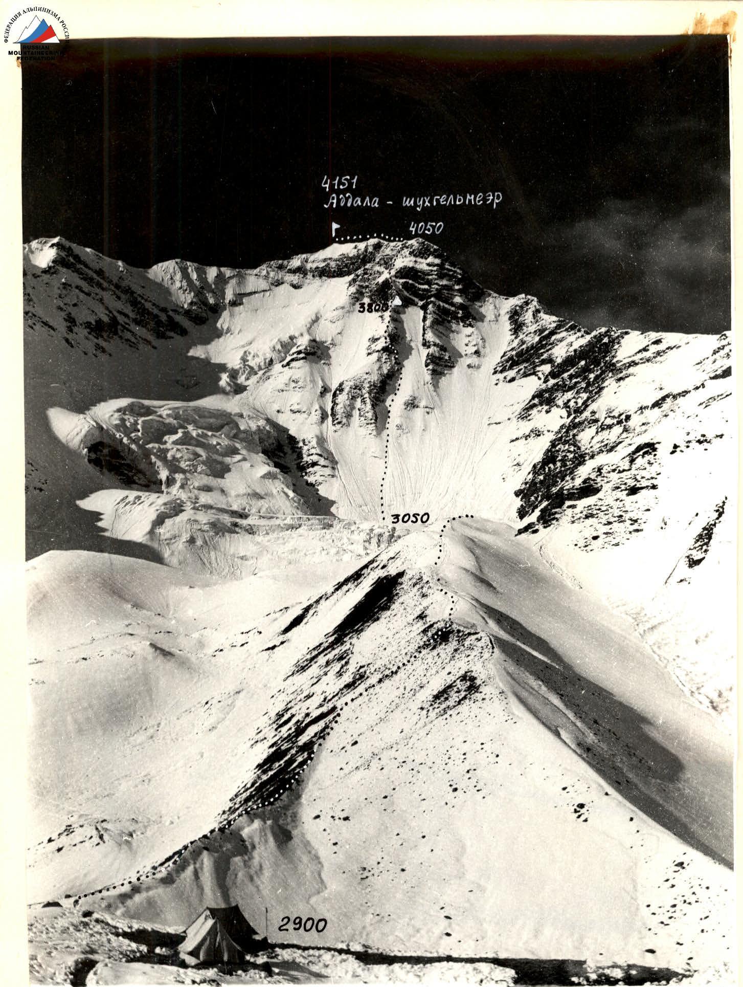
Photo 1. General photo of the summit. ... — team route, Δ — bivouacs. June 2, 1984. Lens T-22, F = 75 mm, Distance ≈ 2.6 km (to the summit). T.S. №1. h ≈ 2900 m.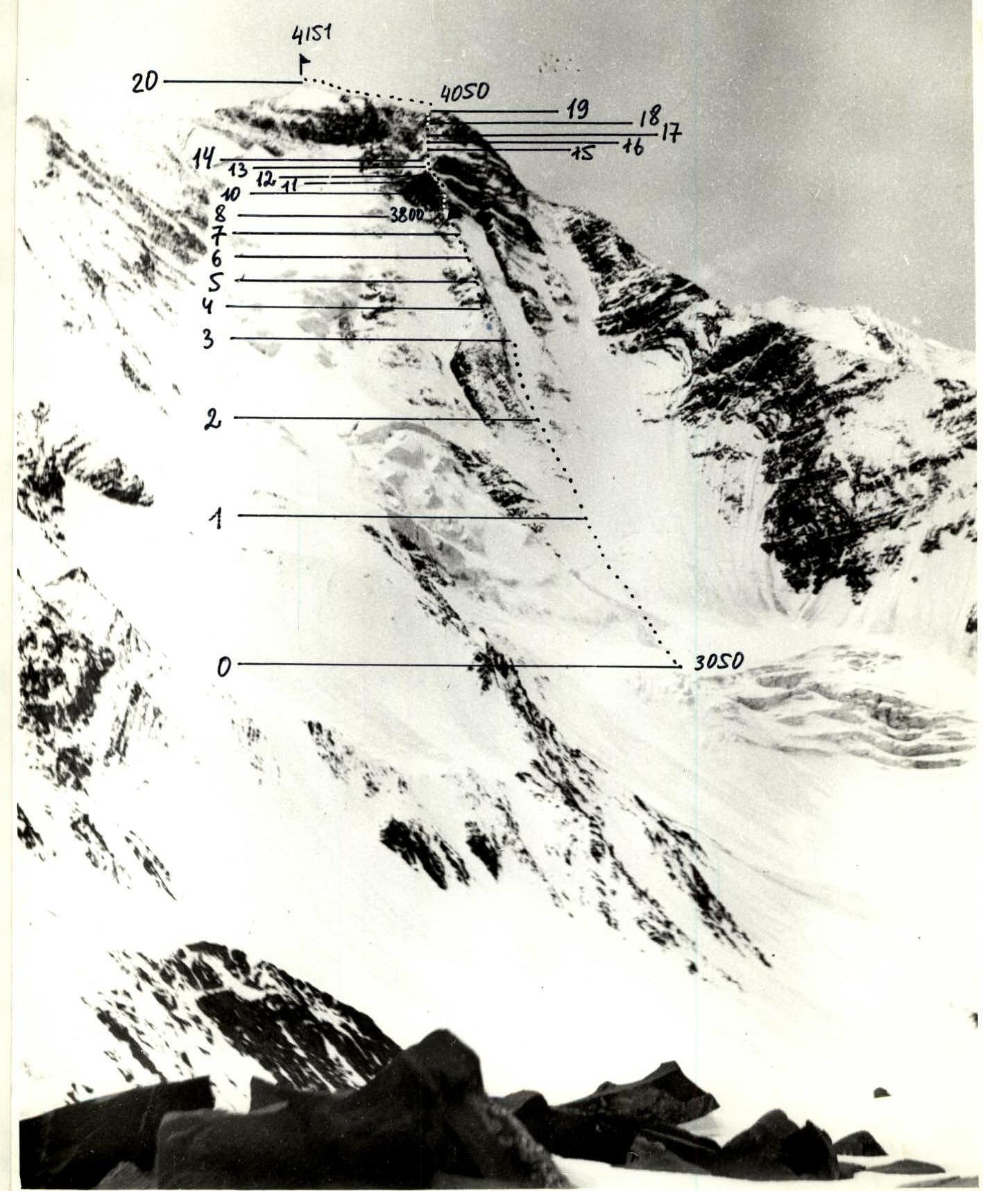
Photo 2. Profile of the wall from the left. ... — route. Δ — bivouac. June 2, 1984. 13:00. Lens T-22, F = 75 mm. Distance ≈ 3.6 km. T.S. №2. h ≈ 3400 m.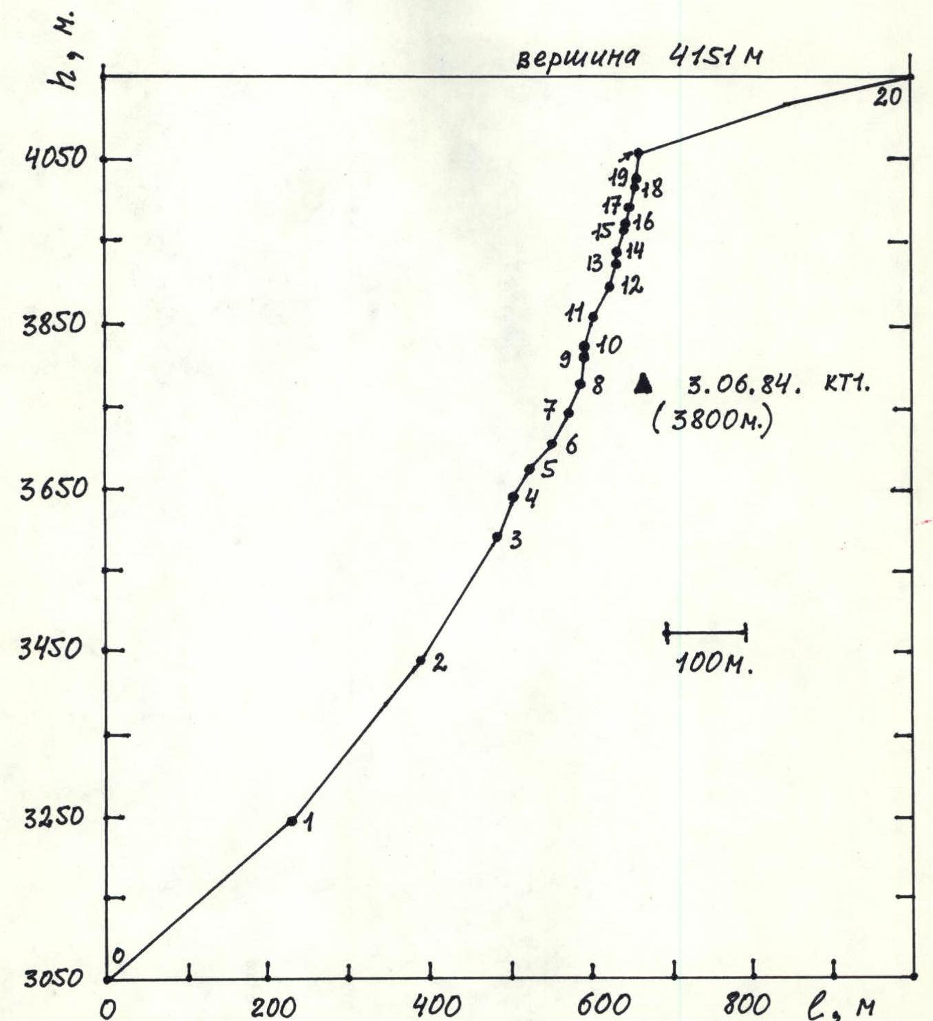
Hand-drawn profile of the route. Map-scheme of the area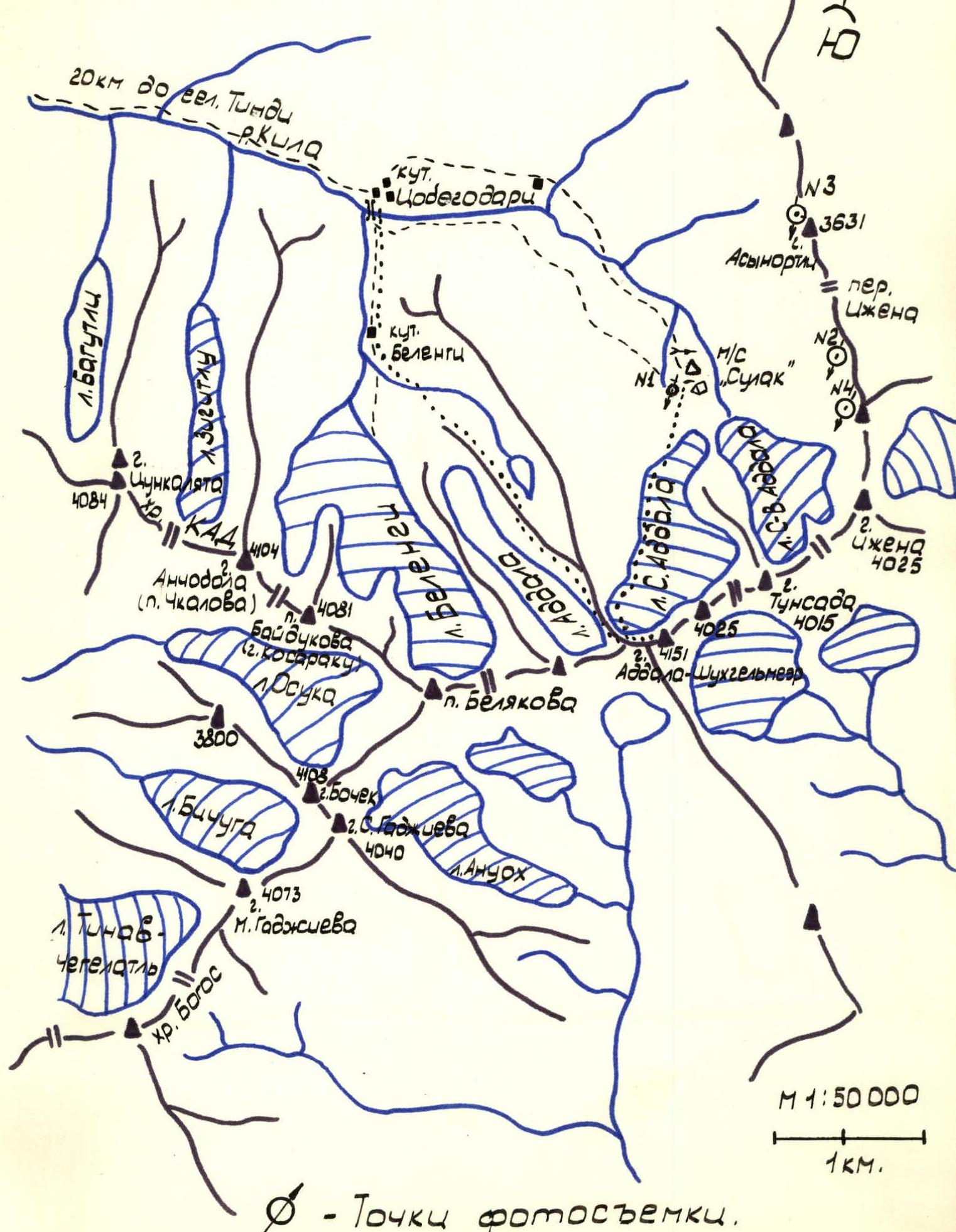
BRIEF OVERVIEW OF THE CLIMBING AREA
The summit of Addala-Shukhgelmeer is located in the center of the northern node of the Bogossky ridge and is its highest point. The Bogossky ridge branches off to the N.-E. from the relatively low in the N.-W. part of Dagestan Main Caucasian ridge. All the peaks of this node are typical representatives of the slate Dagestan peaks. Layers of clay slates alternate with interlayers of more durable sandstone or limestone. The direction of the layers is diverse, up to vertical. The northern node of the Bogossky ridge («ice Bogos») has a significant portion of Dagestan's glaciers (1). The relatively powerful glaciation of Bogos is associated with its overwhelming height and the peculiarities of its orientation — the ridge is located perpendicular to the humid North-Western winds. There is a significant amount of precipitation here. The weather is highly unstable, with frequent thunderstorms in any season except winter.
On Mt. Addala-Shukhgelmeer, there is a single route of 1B category of difficulty via the N.-W. ridge from the Chakatly glacier (S. Gadzhiev, 1940). The northern and north-eastern walls of the summit are of the greatest interest to climbers, dropping over 1 km. The walls' rocks are heavily destroyed. There is a lot of formed ice at any time of the year.
Approach:
- From Makhachkala to the village of Agvali, TsUMADINSKY district, DASSR, it takes 8 hours through inner Dagestan or via the village of Vedeno, ChIASSR.
- From Agvali to Tindi — 16 km of dirt road.
- Further, 20 km along a good trail through the Kila River valley to the Khutor Tsobegodari — the last settlement in this picturesque valley.
- Another 3–4 hours of steep ascent along the trail, going along the left orographic bank of the Kila River, is required to reach the «Sulak high-mountain» weather station — 2900 m.
The weather station operates year-round and is located 1.5 km from the N. wall of Mt. Addala-Shukhgelmeer. The summit is rarely visited.
Literature
(1). Znamenskaya O.M. Glaciation of the Bogossky ridge. — Caucasus. Glacial regions — Ed. by S.V. Kolesnik. — Proceedings of glacial expeditions. Issue 1. — L., 1936. — 102 p.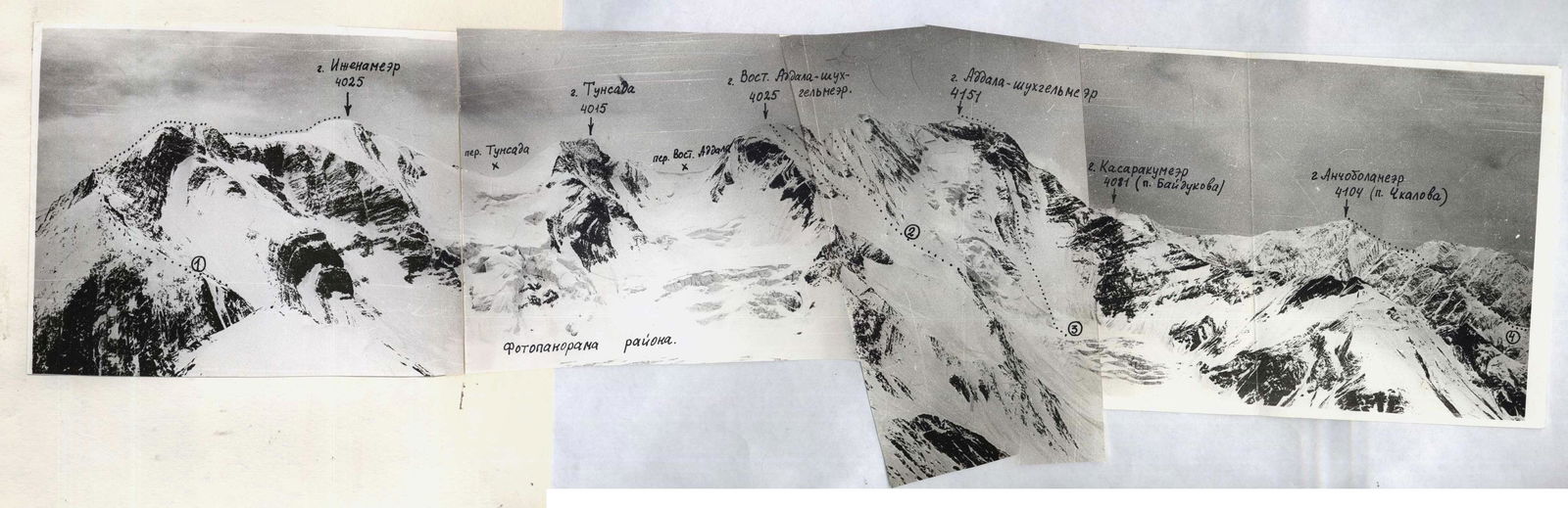
Photo 3. Photopanorama of the area. ① Iژنnameer via N. ridge-2A. ② Addalashukh-gelmeer (B) via N. ridge-2B. ③ The described route. ④ Anchobalameer via N. ridge 2A. Taken on June 2, 1984. 14:30. Lens «Industar-50», F = 50 mm. T.S. №3. h ≈ 3500 m.
TACTICAL ACTIONS OF THE TEAM
Departure from the base camp, located on the platforms near the weather station, at 00:30. Start of movement on the route — 02:00. Each team member had a headlamp. On section № 0–1, the movement was simultaneous in crampons on firn.
Section № 1–2 represents a steep ice slope covered with 10–20 cm of firn. The lead (Smotrov S., Leonov P.) went out on the entire rope using ice screws. Ropes were attached to ice screws.
Section № 2–3 — a steep ice slope. The leader was belayed with a double rope. Ropes were continuously hung. At least two ropes were fixed at four points at the same time. Movement was as fast as possible.
Passing such a section at night required:
- good organization
- teamwork
Teamwork was regulated by team captain Krasnopolsky Yu.
On section № 3, the lead rope was changed (Pashuk E., Smotrov A.). And further, until the exit to the summit ridge, this rope worked with a double rope (except for section № 4–6).
At point R11, a large stance was organized, and by 10:00, the last participant exited the ice gully to R11. Thus, the tactical plan was fulfilled. Further movement was carried out with continuous rope fixing. The length of the ropes never exceeded two ropes. No more than two participants moved at the same time. Two participants constantly monitored rockfall danger.
At 14:00, the group reached section №8. (R15). Here, a platform for a seated bivouac was trampled. Meanwhile, the lead rope continued to process the route.
A very difficult section R15–R17 (slate wall) was passed by Smotrov A. «Slate» pitons were used for belaying. By 19:00, the wall processing was completed.
The group bivouacked at the planned location (sect. № 8, k.t.1). Radio communication with observers was stable. The night was frosty.
On June 4, 1984, at 08:00, they started on the route. The lead rope's composition did not change. After exiting to section 11, the group was under an overhanging snow cornice. Movement in the first half of the day after a frosty night guaranteed safety.
Additionally:
- On sections № 11–13; № 14–16; № 16–18, only the lead rope was processed.
- The following rope moved along the fixed ropes.
- Participants concentrated in well-protected areas — in niches under overhanging walls (sect. № 13, 16, 18).
A very difficult wall, sect. № 17–18, was climbed free solo by Smotrov A. Climbing was extremely difficult.
The wall, sect. № 18–19, was first climbed by Pashuk E. Climbing was extremely difficult, using artificial climbing techniques (ACT).
At 16:30, the group reached the summit ridge. At 18:00, everyone was on the summit. A pre-scouted descent via route 1B category of difficulty to the N.-W. and to the kutar Tsobegodari took 2 hours 30 minutes.
The high pace of movement, required by the route's safety, did not allow the team to rest and have lunch during the day on both climbing days. There is no place for this on the route (except k.t.1). Therefore, each participant had an individual set of products for full nutrition and a juice reserve.
3250 m
- 250 m, 4, 50°
 (3050 м)
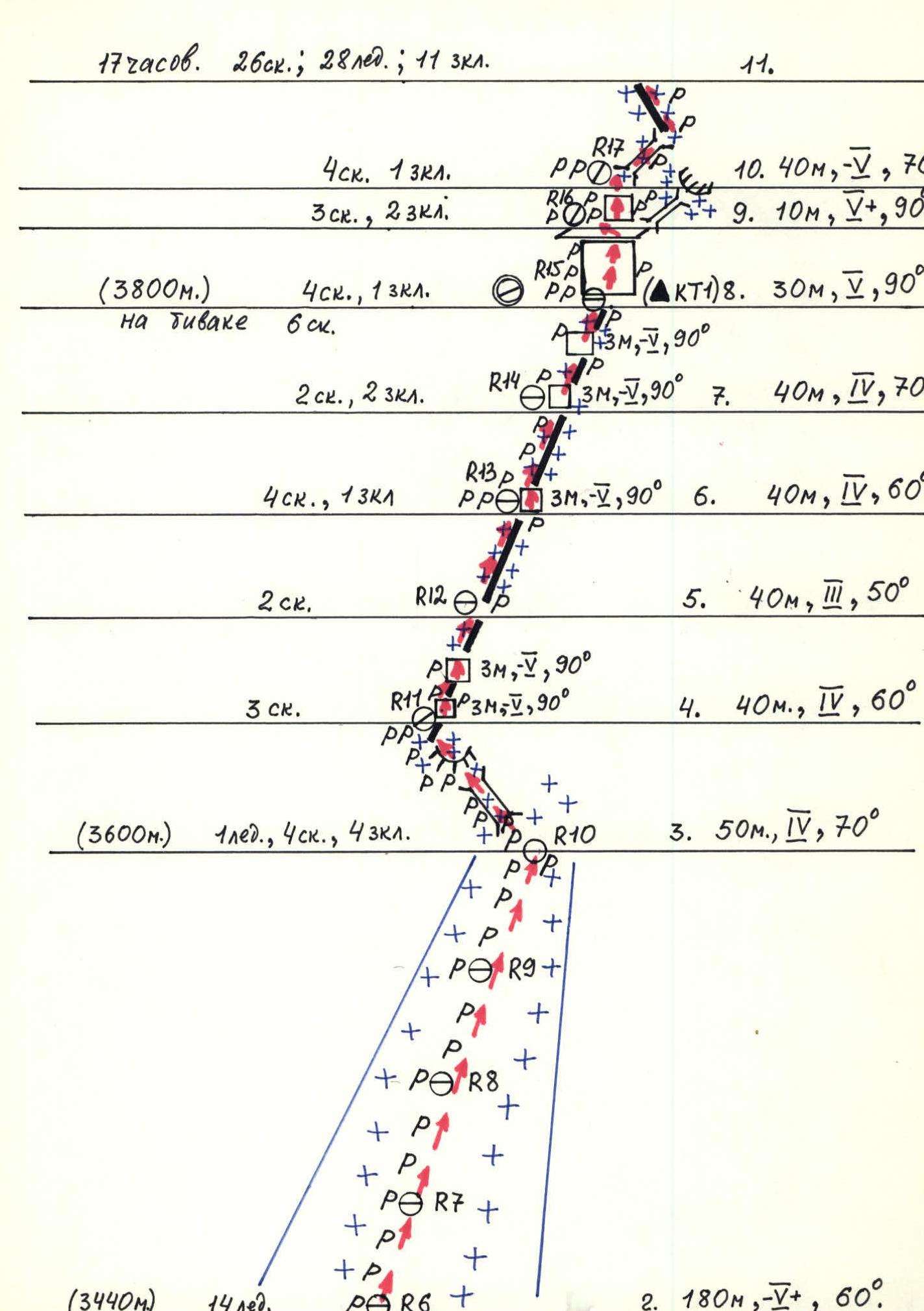
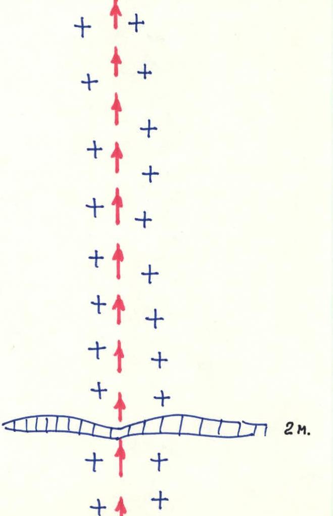
Scheme of the route in symbols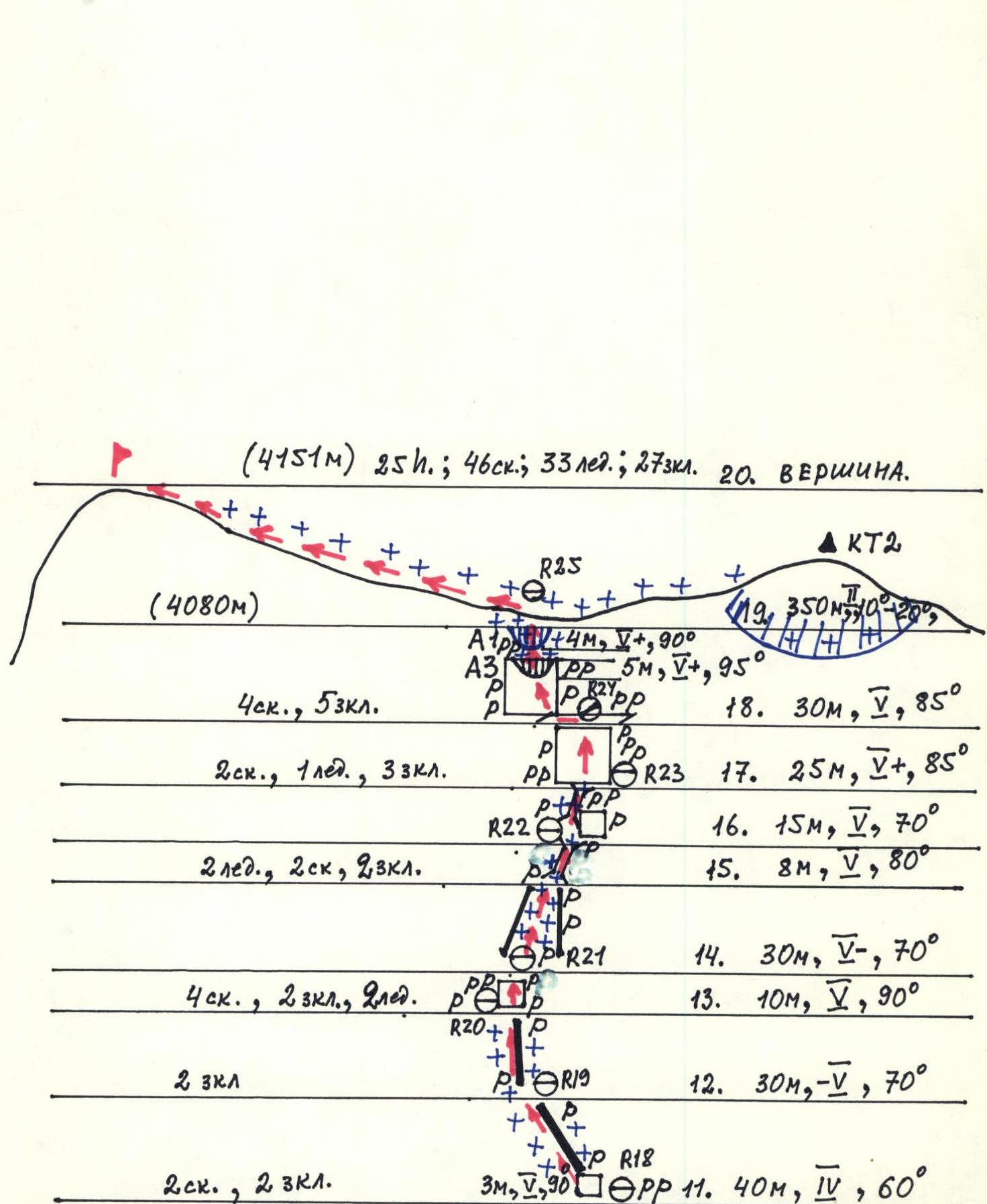
DESCRIPTION OF THE ROUTE BY SECTIONS
Section № 2–3 — a steep ice slope, lightly dusted with snow. The ice is very hard. Movement on front points required great effort. The route's feature does not allow passing this section during the day. Ice screws are hard to screw into frozen ice.
Section № 3–4 represents an exit from the ice gully to the counterfort. The rocks are destroyed and icy. There are sections with formed ice. The first climbed in crampons. At point R11, under a monolithic 3 m wall — a ledge for one. A large stance was organized here, and everyone quickly left the gully.
Movement along the snowy slate ridge on sect. № 4–8 is notable for the fact that the main belay points can be reliably organized only on «slate» pitons. Short but very steep and lacking reliable holds, the walls on this ridge are climbed «head-on».
On sections № 5–8, snow anchors were used for intermediate belays, marked on the diagram as chocks.
The inclined fall of slate layers makes the passage of sections № 6–8 problematic in the absence of a dense snow cover.
The first 2–3 m of the wall, sect. № 8–9, — monolithic limestone. Further, there is a slate overhang. On the steep snowy slope of the ridge under the wall, sect. № 8–9, a platform is trampled. Control cairn in a tin — on a rock piton. The bivouac is seated. For each participant, a piton is driven, and rigid belay is made. The bivouac is protected and safe.
Passing the slate overhang № 8–9 requires extremely difficult climbing. Holds are small. There are few cracks suitable for driving «slate» pitons. Regular pitons do not provide attachment points, even for ACT.
From a wide ledge for two (R16) to the right, a narrow icy chimney goes, ending in a destroyed cornice. This option was tested and rejected, and a slightly overhanging slate wall, sect. № 9–10, was climbed. The first 6 m — movement from «piton to piton», further, there are no cracks. Climbing is free, at the limit of possibilities, using microrelief. At point R17 — hanging belay.
A steep icy chimney (sect. № 10–11) leads to a snowy slate rib. Here, the first climbed in crampons. Ropes are fixed on «slate» pitons.
The rib, sect. № 11–13, was covered with loose snow. Steps did not hold. The first dug a trench and continuously slid down with crampons on icy inclined slate slabs. Movement required great physical tension.
Under the wall, sect. № 13–14, there is a niche for two. The steep wall № 13–14 is heavily destroyed. Movement on snowy, unreliable holds required frequent intermediate belay points.
The wall at point R20 turns into a weakly expressed ice gully. Under the overhanging monolithic wall R22 — a protected place for two.
A not ярко expressed internal corner with sections of ice and rocks like «ram's foreheads» (sect. № 16–17) the first climbed in crampons. Holds here are smoothed and iced.
The steep wall, sect. № 17–18, consists of large monolithic limestone blocks with heavily destroyed interlayers of slate. Climbing is extremely difficult. Holds are few and unreliable. Widely used:
- friction,
- jamming hands and feet in gaps between blocks.
On the inclined ledge R24, one participant is protected by a rock cornice from falling ice and snow from above. From here, movement 3 m left up along the icy steep slab under the steep monolithic wall containing an overhanging section and a 1 m cornice. Movement «from piton to piton».
Passing the rock cornice is extremely complicated by its block structure — cracks diverge when driving pitons, chocks hold unreliably.
The snow cornice in this place is the shortest and least steep. Movement with two ice axes, on one of which a ladder was hung.
The summit dome is snowy. There is a rock outcrop on which a trig point stood, and under it, a cairn. The second control cairn is built 20 m to the right from the exit to the summit ridge — on a rock shoulder.
Descent down to the right — traversing in the upper part of the Addala glacier, via the N.-W. ridge of the summit — into a snow cirque, and along it to the kut. Belenge.
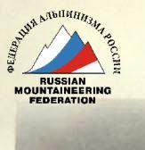
Photo 4. T.S. №4 (see back)
Photo 4. Technical photo of the route. Taken on June 2, 1984. 10:00. Lens T-22, F = 75 mm, distance ≈ 2.6 km to the summit. T.S. №1. h ≈ 2900 m. (Enlarged fragment from 6×6 cm film, photo №1)