Report
On the ascent to the summit of Koazoy–Loam (Kyazi) via the left part of the southwest wall, category 6A complexity, by the team Stavropol Territory – 2, from 04.02.2020 to 13.02.2020 2020
Ascent Passport
| 1. General Information | ||
|---|---|---|
| 1.1 | Full name, sports rank of the team leader | Sergey Alikovich Livinsky, CMS |
| 1.2 | Full name, sports rank of the participants | Alexander Petrovich Budnikov, 1st sports rank, Alexey Nikolaevich Ivanov, 1st sports rank, Sergey Vladimirovich Reshetik, 1st sports rank |
| 1.3 | Full name of the coach | Vladimir Ilyich Enin |
| 1.4 | Organization | Stavropol Regional Federation of Alpinism |
| 2. Characteristics of the Ascent Object | ||
| 2.1 | Region | Caucasus from the Krestovy Pass to the Shaviklde peak |
| 2.2 | Valley | Kyazi Alpine Camp |
| 2.3 | Section number according to the 2013 classification table | p. 2.9 |
| 2.4 | Name and height of the summit | Koazoy–Loam (Kyazi Central) 3100 m |
| 2.5 | Geographic coordinates of the summit (latitude/longitude), GPS coordinates (1) | |
| 3. Characteristics of the Route | ||
| 3.1 | Route name | via the left part of the SW wall |
| 3.2 | Proposed category of complexity | 6B |
| 3.3 | Degree of route exploration | second ascent |
| 3.4 | Relief characteristics of the route | Rocky |
| 3.5 | Route elevation gain (altimeter or GPS data) | 730 m |
| 3.6 | Route length (in meters) | 1260 m |
| 3.7 | Technical elements of the route (total length of sections of varying complexity with relief characteristics (ice-snow, rocky)) | IV category rocky – 380 m. V category rocky – 280 m. VI category rocky – 290 m. VI+ category rocky – 220 m. Rocky VI, A2 – 245 m. Rocky VI, A3 – 37 m |
| 3.8 | Average steepness of the route, ° | 64 |
| 3.9 | Average steepness of the main part of the route, ° | 80 |
| 3.10 | Descent from the summit | Via 4B category to the Kyazi Alpine Camp |
| 3.11 | Additional route characteristics | No water in summer |
| 4. Characteristics of the Team's Actions | ||
| :--: | :--: | :--: |
| 4.1 | Time of movement (team's working hours, in hours and days) | 78 working hours, 9 days |
| 4.2 | Overnight stays | Platform, shelf, grotto |
| 4.3 | Route preparation time (3) | hours, days |
| 4.4 | Departure to the route | 8:27, February 4, 2020 |
| 4.5 | Summit attainment | 19:25, February 12, 2020 |
| 4.6 | Return to the base camp | 15:00, February 13, 2020 |
| 5. Weather Conditions Characteristics (4) | ||
| 5.1 | Temperature, °C | 04–07.02.2020 daytime –3…–5, nighttime down to –10 °C; 08.02.2020 towards evening down to –27 °C; 09.02.2020 morning down to –32 °C, daytime –27…–30 °C; 10.02.2020 daytime down to –25 °C; 11–12.02.2020 daytime down to –14 °C; 13.02.2020 daytime down to –10 °C. |
| 5.2 | Wind force, m/s | 08–09.02.2020 up to 10 m/s; 10.02.2020 up to 15 m/s |
| 5.3 | Precipitation | February 8, 2020 heavy snowfall |
| 5.4 | Visibility, m | |
| 6. Responsible for the Report | ||
| 6.1 | Full name, e-mail, phone | Sergey Alikovich Livinsky, LiS-nc@yandex.ru, +7(918) 741-16-18 |
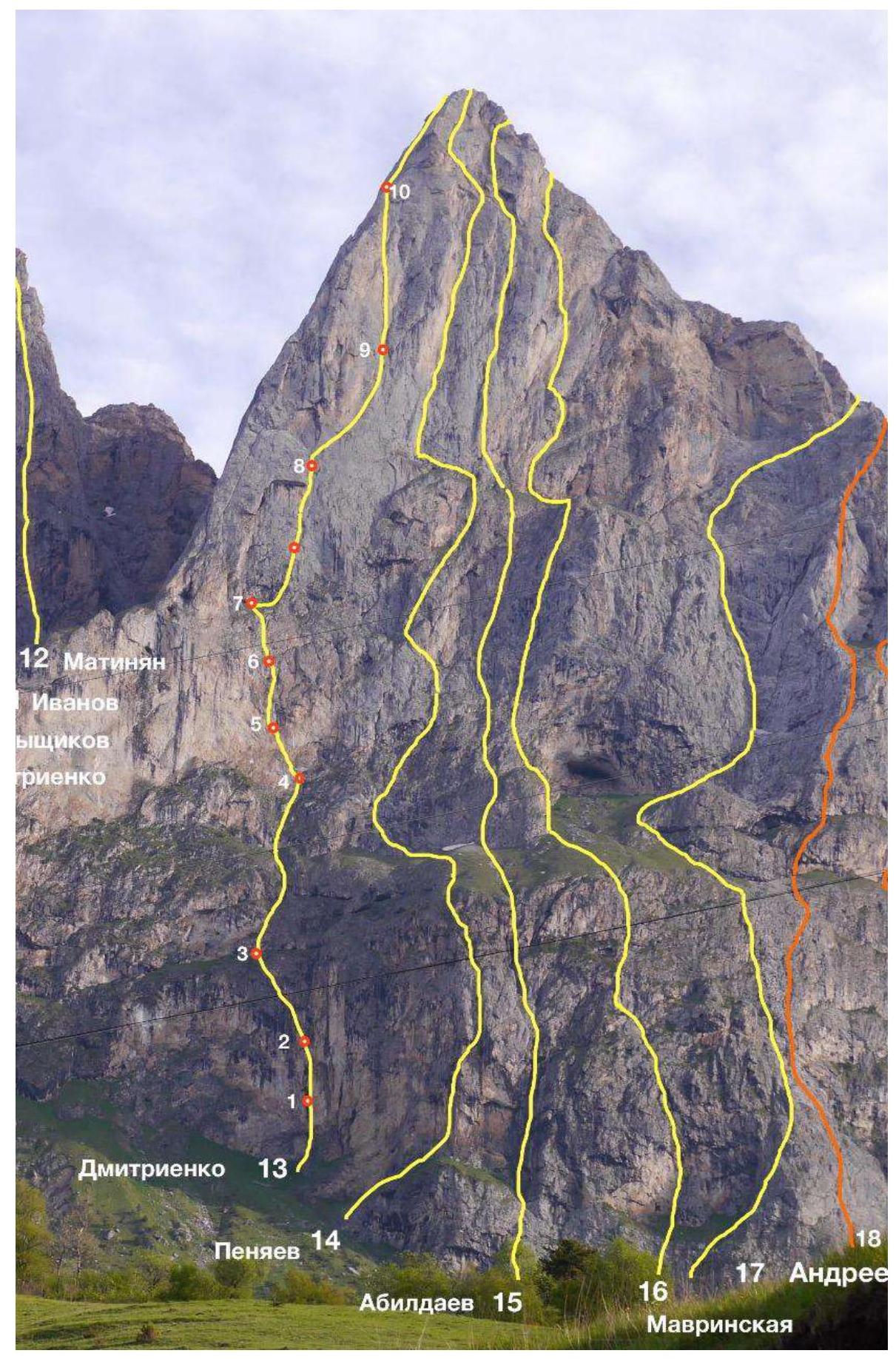
Figure 1 — View of the route
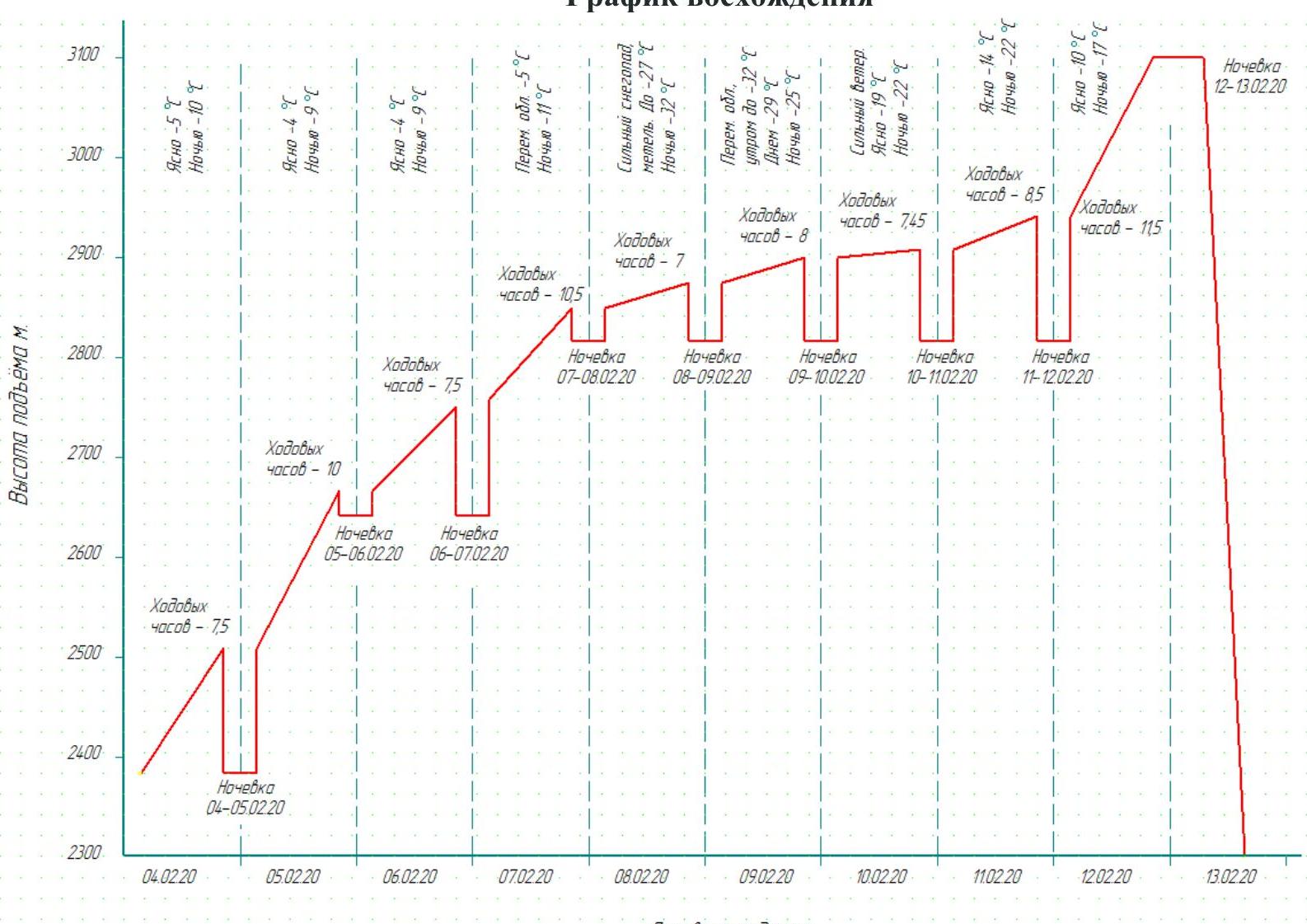
Ascent Schedule
Overview of the Ascent Area
The Koazoy–Loam Central peak is located in the Rocky Ridge of the Greater Caucasus, in the section of the ridge between the Terek (to the west) and Assa (to the east) rivers. The Koazoy–Loam Central peak is part of the Koazoy–Loam massif, which also includes the Main and Eastern peaks. Previously, the peaks in the classifier had the name "Girech", later – "Gaikomd".
The ascent route and approaches are located on the territory of the Dzheyrakhsky district of the Republic of Ingushetia.
Before the ascent, it is most convenient to base at the "Kyazi" alpine camp, 100 m before the turn to the "Besht detachment" border outpost. Border permits are not required for the Koazoy–Loam peaks, but it is necessary to notify the outpost of your presence in the area.
Cellular communication – only Beeline, Megafon networks, and on the wall and at the top – MTS.
The weather in the area is quite stable; snowfall periods last 2–3 days, and snow on the routes melts very quickly. This should be taken into account during prolonged wall ascents.
The approach to the route takes about an hour and a half. Move in the direction of the southern walls of the Gaikomd Main peak along the grassy ridge; 300 m before the wall, on the flattening of the ridge, above the forest level, turn right and cross the couloir between the Koazoy–Loam Main and Koazoy–Loam Central peaks. Then up about 100 m; the start of the route is to the right of a huge niche in the wall. The niche can accommodate a comfortable overnight stay.
The Gaikomd ridge is composed of sedimentary rocks – limestone. The relief of the wall is very reminiscent of the Crimean walls: Morcheka, Forossky Kant, Sokol.
The ascent route passes through the most monolithic part of the Koazoy–Loam Central wall; only a small section on the second rope above the niche is destroyed.
Tactical Actions of the Team
In February 2020, the Stavropol Territory – 2 team participated in the face-to-face Russian Championship in Alpinism in the technical class. During the draw, the team chose this route, although, as far as we knew, there was no second ascent, and the route description occupied three lines. It was very helpful that the route author, E. Dmitrienko, consulted with us.
On February 4, 2020, the Stavropol Territory – 2 team, consisting of Livinsky S.A., Budnikov A.P., Ivanov A.N., and Reshetik S.V., left the base camp at 6:00. At 8:10, they were at the start of the route and began working at 8:25. They managed to complete 3 ropes of 50 m during the day.
The second rope took a lot of time because it passes through:
- a destroyed part of the wall,
- with many jammed stones inside,
- layered rock, complicating belaying and not allowing for reliable anchor points.
By evening, fog settled, and it got colder, forcing them to finish work 40 minutes earlier than planned. Livinsky S.A. led, Budnikov A.P. belayed; Ivanov A.N. and Reshetik S.V. observed from the ground.
The next day, the weather improved, and work resumed. The Ivanov A.N. and Reshetik S.V. rope worked together; Reshetik led. That day, they managed to "break away" from the ground and spent the night on the route at the R4 section.
Further work on the route was carried out by ropes alternately. One rope worked the entire day, for example, Budnikov–Livinsky, while the Ivanov–Reshetik rope rested or worked on haulage. The next day, there was a change, and the "rested" rope worked.
The significant slowdown in the route's progress was due to the deterioration of the weather on February 8, 2020. Snow began to fall, and the temperature dropped rapidly. Due to the temperature difference between the rocks and the surrounding air:
- snow stuck to the rock;
- cracks for fifi hooks or anchors had to be searched for after thorough and lengthy digging with gloved hands.
Gloves naturally got wet quickly, and hands froze. To make matters worse, after lunch, the temperature began to drop rapidly. On this day, Livinsky led, and Budnikov belayed. Luckily, they spent the night in a grotto.
The next day, Ivanov–Reshetik (leader) worked; the snowfall stopped, but it was even colder. Later, they learned that the temperature that day was –32 °C. They even had to change the belayer.
In the following days, the weather slowly but surely improved. Along with the improvement in weather, the speed of movement on the route increased. On February 12, 2020, they reached the summit at 19:25.

Figure 2 — Photo of the upper part of the route

Figure 3 — Photo of the third quarter of the route
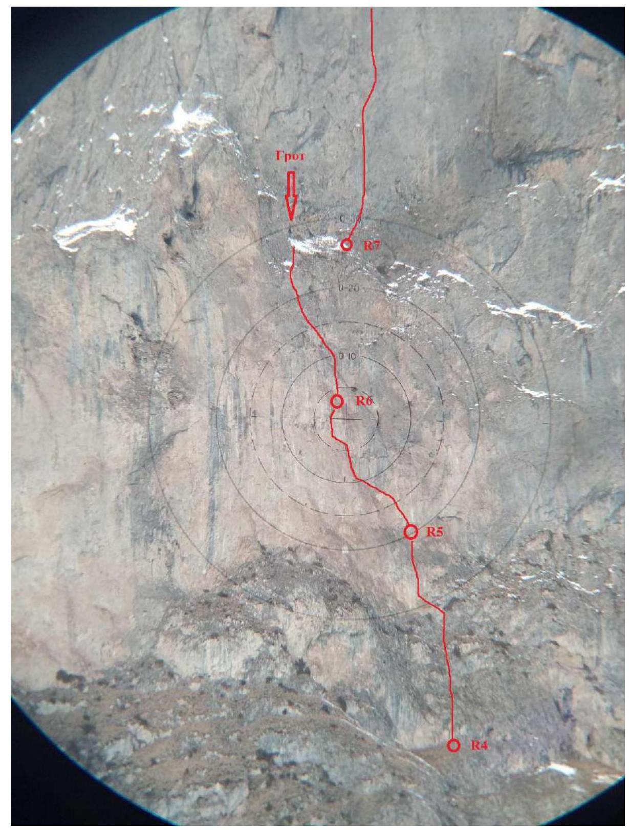
Figure 4 — Photo of the second quarter of the route

Figure 5 — Photo of the lower part of the route
| Section # | Anchor pins | Fifi hooks | Nut placements | Bolts | Route line, in UIAA symbols | Section characteristics |
|---|---|---|---|---|---|---|
| Total | 90 | 73 | 102 | 3 | ||
| 11 | 3 | 62 | Further along the route to the summit R10 | 5–5, 200 m, 75–80° | ||
| 10 | 15 | 13 | R9 | 5–6, A2–A3, 200 m, 80–90° | ||
| 11 | 21 | 2 | ||||
| 9 | 17 | 19 | 3 | 1 | R8 | 6+, A2, 120 m, 80–90° |
| 8 | 13 | 8 | 8 | 2 | R7 | 6+, A3, 100 m, 80–90° |
| 7 | 13 | 8 | R6 | 5, 80 m, 75–80° | ||
| 6 | 12 | 10 | 8 | 2 | R5 | 5+, A3, 50 m, 80–90° |
| 5 | 7 | 10 | 1 | R4 | 5+, A1, 50 m, 80–90° | |
| 4 | 7 | 42 | R3 | 5, 250 m, 75° | ||
| 3 | 11 | 15 | 2 | R2 | 6, A2, 100 m, 80–85° | |
| 2 | 5 | 9 | R1 | 5, 80 m, 80° | ||
| 1 | 7 | R0 | 4, 30 m, 75° |
Route Description by Sections
R0–R1. Start to the right of the large cave (niche). Up to the upper edge of the cave: 30 m, free climbing 4 category, 75°. The relief is monolithic.
R1–R2. Further above the cave, traverse left and up towards the system of internal corners and cracks leading straight up: 30 m, free climbing 5 category, 80°. Poor belay, heavily destroyed.
R2–R3. Up and slightly left through the system of internal corners, cracks, then a chimney with a plug and under an overhang: 100 m, free climbing 6 category with short sections of AID, 80–85°, A1.
The overhang is bypassed left and up on AID to exit onto a ledge: 10 m, 80–85°, A2.
R3–R4. Along ledges alternating with small walls, up to the red wall:
- 250 m,
- 4 category,
- 75°.
R4–R5. Up slightly left through a series of cracks and small walls: 50 m, movement by free climbing with sections of AID, 5+ category, 80–90°, A1.
R5–R6. Through a series of cracks and splits up and slightly left, overcoming a small overhanging section at the end (about 3 m, passed on AID A3): 50 m, movement on AID with sections of free climbing, 5+ category, 80–90°, A3.
R6–R7. Up through grass-covered rocks to a ledge with a grotto: 80 m, 5 category, 75–80°. The grotto provides a comfortable bivouac for 4 people.
R7–R8. From the cave, traverse right along the ledge 10 m, then up to the right edge of the G-shaped cornice: 100 m, movement on AID (fifi hooks, anchors), 2 bolts, 6+ category, 80–90°, A3.
R8–R9. From the edge of the G-shaped cornice, traverse right (fifi hooks, anchors) with a slight gain in height, bypassing the overhang with rocks of a reddish color: 120 m, 6+ category, 80–90%, A3.
R9–R10. Up along the system of cracks and internal corners on their right wall to join the 4B route "Koazoy – Loam via the SW edge, Loginov I., 2017". The junction with the 4B route is at a corner with a section of reddish, heavily destroyed rocks (about 7 m, passed on AID A3):
- About 200 m,
- there are sections of free climbing 5–6 category for 15–20 m each,
- but mostly (70%) on AID, 80–90°, A2–A3.
R10–R11. Further to the summit via the 4B route "Koazoy – Loam via the SW edge, Loginov I., 2017". About 150 m of climbing, 4–5 category.

Figure 6 — Photo: work on the R1–R2 section
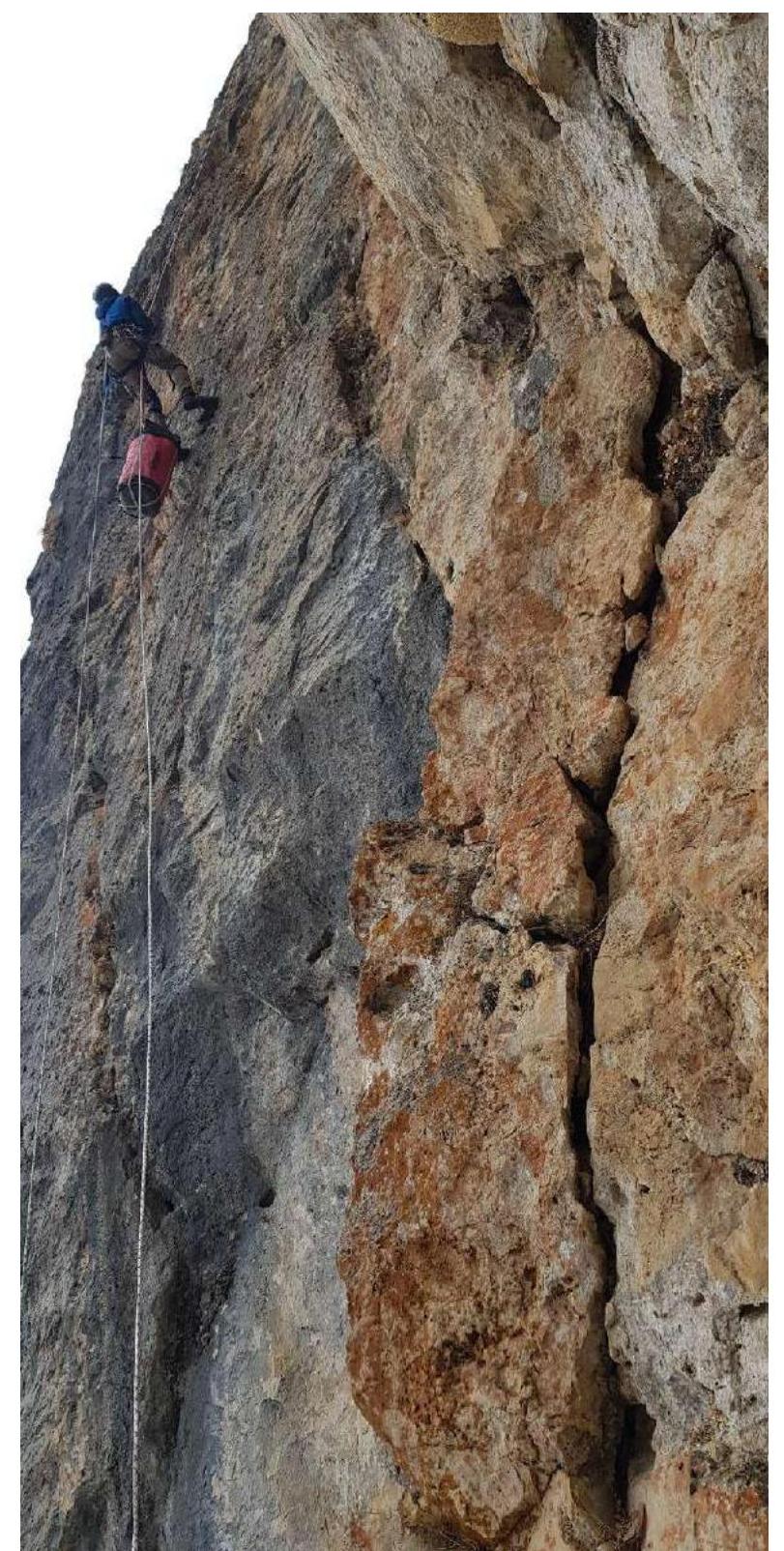
Figure 7 — Photo: ropes on the R2–R3 section
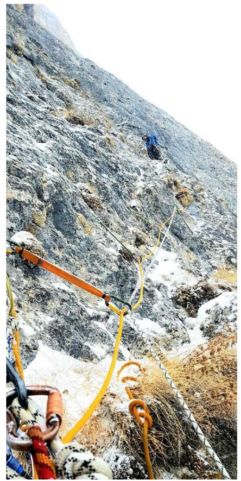
Figure 8 — Photo: work on February 8, 2020, on the R7–R8 section
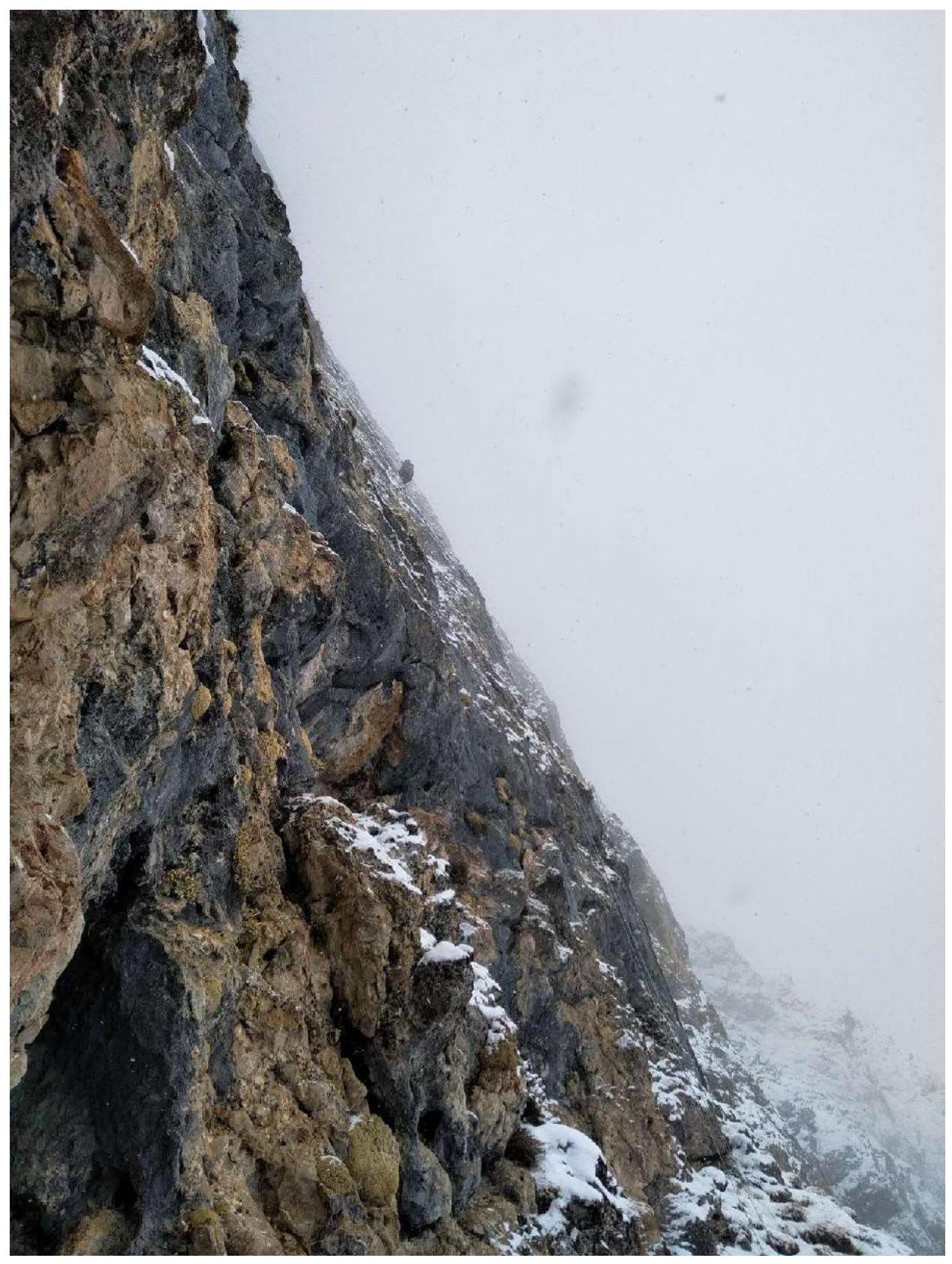
Figure 9 — Photo: work on February 8, 2020, on the R7–R8 section, view from the grotto entrance
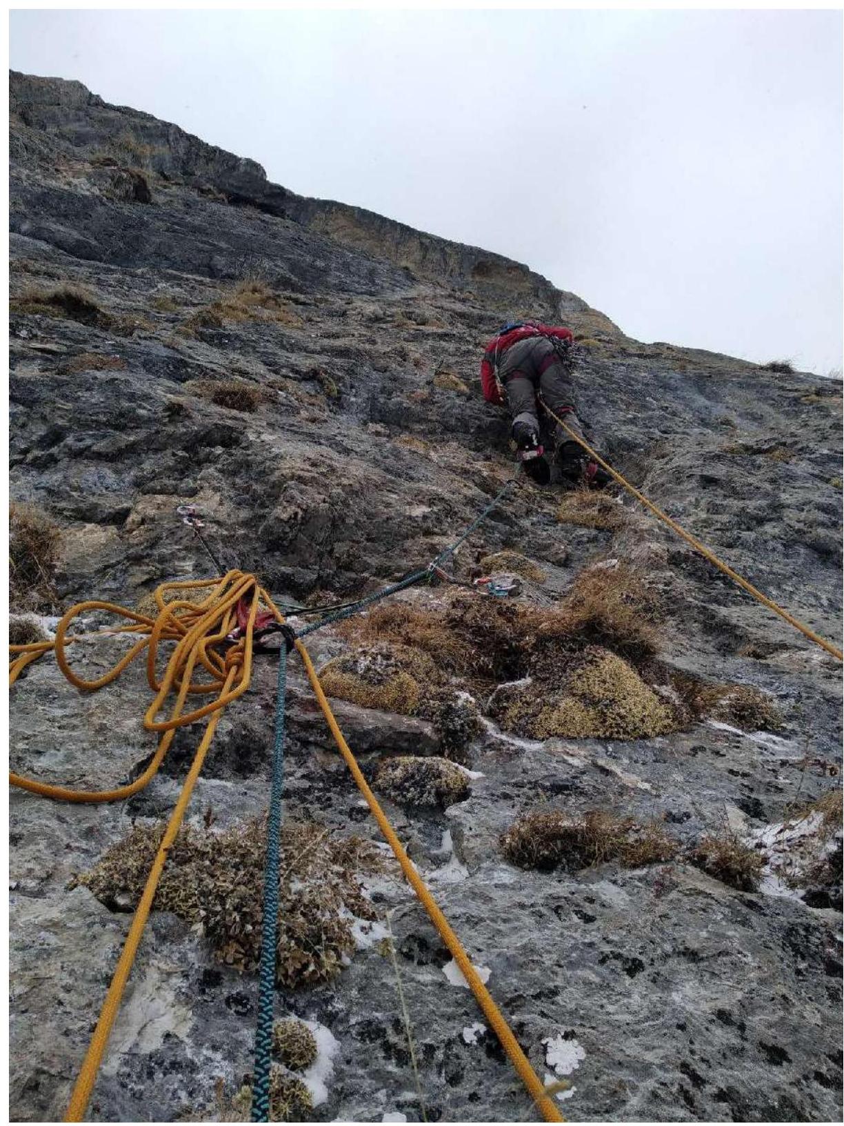
Figure 10 — Photo: work on February 9, 2020, on the R7–R8 section
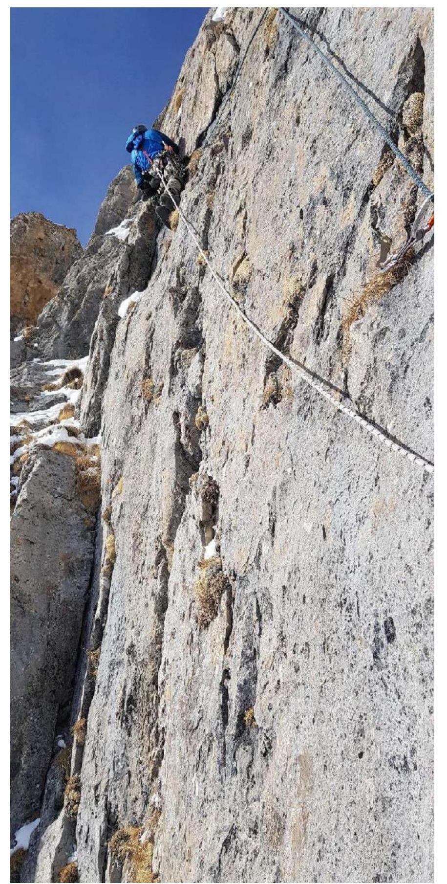
Figure 11 — Photo: work on the R9–R10 section before exiting to the ridge

Figure 12 — Photo: morning of February 13, 2020, on the summit