
Ascent Passport
- Ascent class — combined
- Ascent area — East Caucasus, Shanava ridge
- Peak, its height, route — p. Kichcechcort, 4133 m.
via South ridge (through j. "Bolshoy")
- Route characteristics: a) rope length height — 900 m. b) route length — 1800 m. c) average route steepness — 45°
- Pitons hammered for belay (I.T.O.): rock — 20, ice — 2, bolt —
- Number of travel hours on the route:
to the summit — 10 h.
- Number of nights and their characteristics: NONE.
- Proposed category of complexity — 3A.
- Full name of the leader, participants, their qualification:
- Smirnov V.A. — CMS
- Lukonenko A.V. — CMS
- Detkov R.N. — 1st sports category
- Shapovalov V.M. — 1st sports category
- Team coach: Vasilenko A.A.
- Dates of departure on the route and return to the base camp:
a) departure on the route — October 6, 1984
b) reaching the summit — October 6, 1984
c) return to the base camp — October 6, 1984

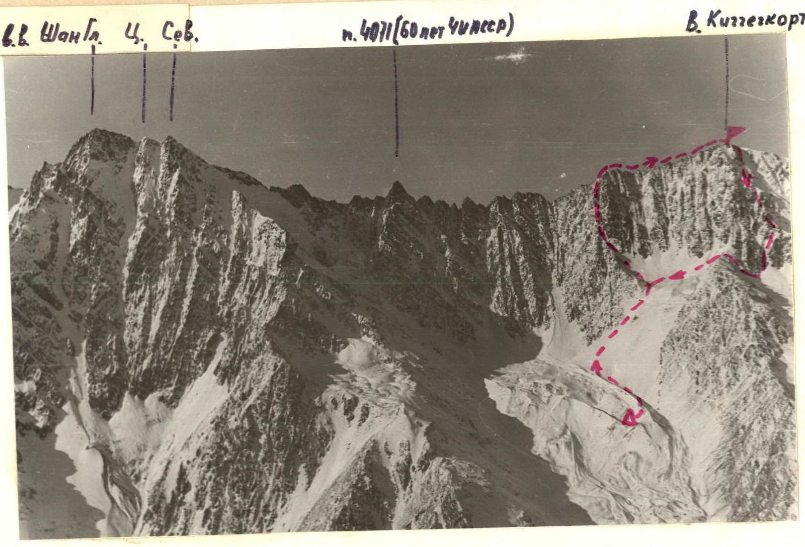
General view of p. Kichcechcort (4133 m)
Description of the Ascent Area
The ascent object is located in the Eastern Caucasus, in the southern part of the ChIASSR, in the Shanava ridge.
The ascent object is located in the center of the Shanava ridge, which divides the gorges of the Kistinka and Shan-Don rivers. The peaks Shan (4451 m), Dzeneladze (4400 m), Rustavi (4350 m), Kichcechcort (4133 m), and others are located in this ridge. Routes have been laid to the peaks of this ridge (from the Kistinka gorge side) from 1 to 4B category of complexity.
No ascents have been made from the Shan-Don river gorge side.
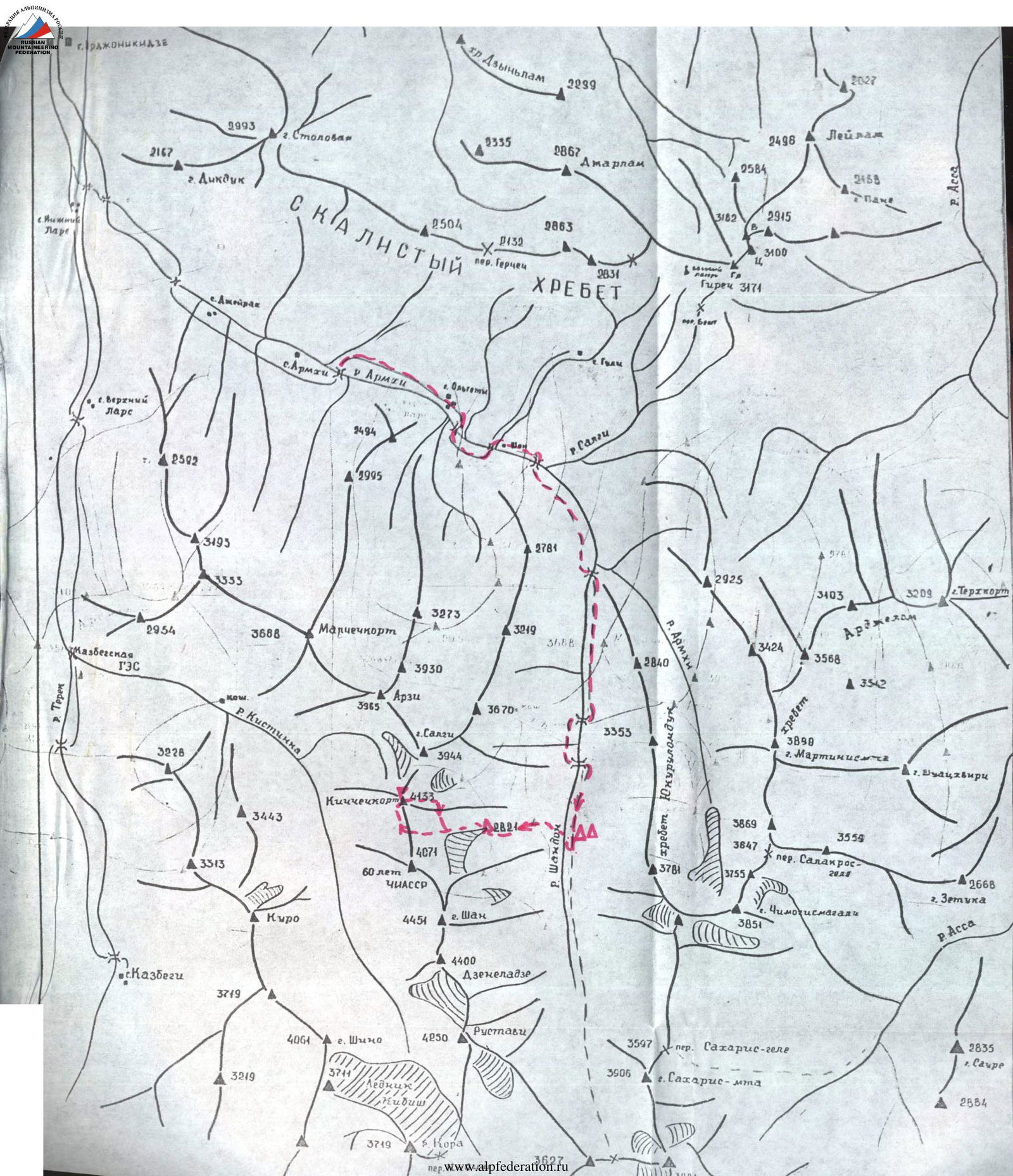
At the 21st km of the Military Georgian Road, the Terek river is joined by its left tributary — the Armkhi river. The highway leads to the village of Armkhi (12 km) — from here, regular buses run from the city of Ordzhonikidze.
From the village of Armkhi upstream along the Armkhi river to the confluence with the Shan-Don river (about 2 hours walk).
Further upstream along the Shan-Don river (direction — South). The gorge is covered with forest, good trail.
At the forest boundary near the lake (2071 m) — base camp from the village of Armkhi — 6–7 hours.
From the base camp, along the left (orographic) bank of the Shan-Don river, ascend the steep forested slope into the Eastern cirque of the Shan-Kichcechcort headwaters. Ascend to the ridge of the terminal moraine of the North Shan glacier. Overnight stay on the lake shore (2821 m) from the base camp 2.5–3 hours.

Route Sections Table
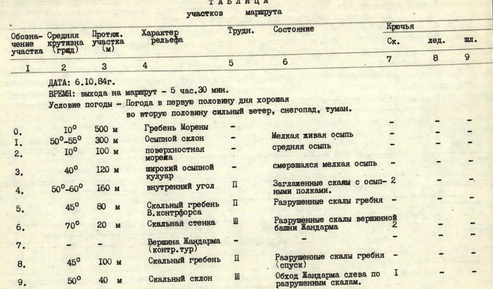
Date: October 6, 1984 Time of departure on the route: 5:30 am Weather conditions: good weather in the first half of the day, strong wind, snowfall, fog in the second half.
| Section designation | Average steepness (degrees) | Section length (m) | Terrain character | Difficulty | Condition | Rock | Ice | Bolt |
|---|---|---|---|---|---|---|---|---|
| R0 | 10° | 500 | Moraine ridge | — | — | — | — | — |
| R1 | 50°–55° | 300 | Scree slope | — | Small live scree | — | — | — |
| R2 | 10° | 100 | Surface moraine | — | Medium scree | — | — | — |
| R3 | 40° | 120 | Wide scree couloir | — | Frozen small scree | — | — | — |
| R4 | 50°–60° | 160 | Inner corner | 2 | Smoothed rocks with scree ledges | 2 | — | — |
| R5 | 45° | 80 | Rocky ridge of the counterfort | 2 | Destroyed rocks of the ridge | — | — | — |
| R6 | 70° | 20 | Rocky wall | 3 | Destroyed rocks of the summit tower of the Gendarme | 2 | — | — |
| R7 | — | — | Summit of Gendarme (control cairn) | — | — | — | — | — |
| R8 | 45° | 100 | Rocky ridge (descent) | 2 | Destroyed rocks of the ridge | — | — | — |
| R9 | 50° | 40 | Rocky slope | 3 | Bypassing the Gendarme on the left along destroyed rocks | 1 | — | — |
| R10 | 60° | 40 | Rocky ridge of Gendarme | 3 | Destruction of rocks of the ridge | 2 | — | — |
| R11 | 80° | 30 | Rappelling to the saddle from the summit of Gendarme | — | Snow-covered rocks | 3 | — | — |
| R12 | 70° | 70 | Rocky ridge | 3 | Destroyed snow-covered rocks | 2 | — | — |
| R13 | 80° | 25 | Rappelling to the saddle from the summit | 3 | Rocky, ice-covered wall | 3 | — | — |
| R14 | 45° | 8 | Ice saddle | 2 | Ice ridge with a cornice | 2 | — | — |
| R15 | 60° | 120 | Rocky ridge | 2 | Destroyed snow-covered rocks of the ridge | — | — | — |
| R16 | 80° | 40 | Descent rappelling to the saddle | 3 | Rocky wall. "Live" stones | 3 | — | — |
| R17 | 50° | 200 | Rocky ridge | 2 | Destroyed, snow-covered rocks of the ridge | — | — | — |
| R18 | 45° | 100 | Snow-ice slope | 2 | Snow-covered ice ridge with cornices | 2 | — | — |
Summit
Travel hours to the summit — 10 h. Descent via the NE counterfort of the East edge.
Route Description
From the base camp at the lakes (2821 m) along the moraine ridge to the beginning of the East counterfort of the "Bolshoy" Gendarme (1.5–2 hours).
Along the wide scree couloir of the right part of the counterfort, approach the beginning of the large inner corner.
Along the smoothed rocks of the inner corner (pitons belay) ascent to the wall of the summit tower of the Gendarme. Control cairn! (2–2.5 hours).
Further to the right along the South ridge (staying on the left part) with the organization of descent from the three subsequent gendarmes. Between R2 and R3 gendarmes — ice saddle with a cornice. Traverse along the left slope. Rocks are covered with ice. Pitons belay.
Further along the steep rocky ridge with exit to the pre-summit snow-ice slope-ridge. Exit to the summit along simple rocks from the summit of the "Bolshoy" gendarme — 5–6 hours.
Descent via the NE counterfort of the East edge.
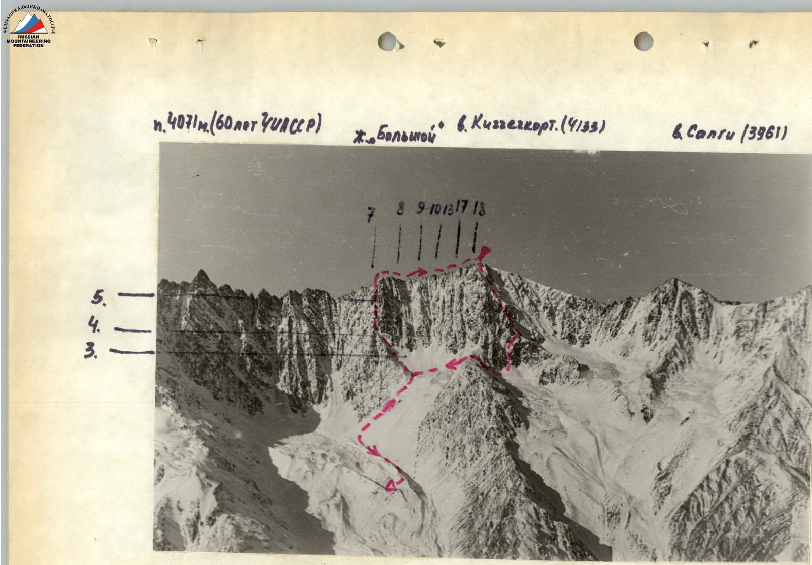
Photo 2. Technical photo of the route.
Comments
Sign in to leave a comment