- Rocky ridge; section number in Classification 2.8
- Tbau Eastern (2832 m), via the Eastern ridge of the South-Eastern bastion.
- Proposed category: 5B; first ascent.
- Route type: rock.
- Route height difference: 912 m (by GPS).
Route length: 1550 m. Length of sections with 5–6 category: 135 m. Average steepness:
- main part of the route: 75°;
- entire route: 65°.
- Pitons left on the route: total – 9 pcs., of which 7 are hammered.
Pitons used on the route:
- removable pitons: 15 pcs., including 12 for ITO;
- stationary pitons: 7 pcs., including 2 for ITO. Total ITO used: 21 pcs.
- Team's working hours: 48 hours; days – 6.
- Team leader: Egorin Sergey Vladimirovich, Master of Sports.
Team members:
- Abisalov Anatoliy Dmitrievich — 1st sports category
- Zhirnov Dmitry Nikolaevich — 1st sports category.
- Senior coach: Khamitsaev Kazbek Borisovich.
Coach: Shchetinin Sergey Viktorovich. Departure to the route: 7:00 AM, March 15, 2006.
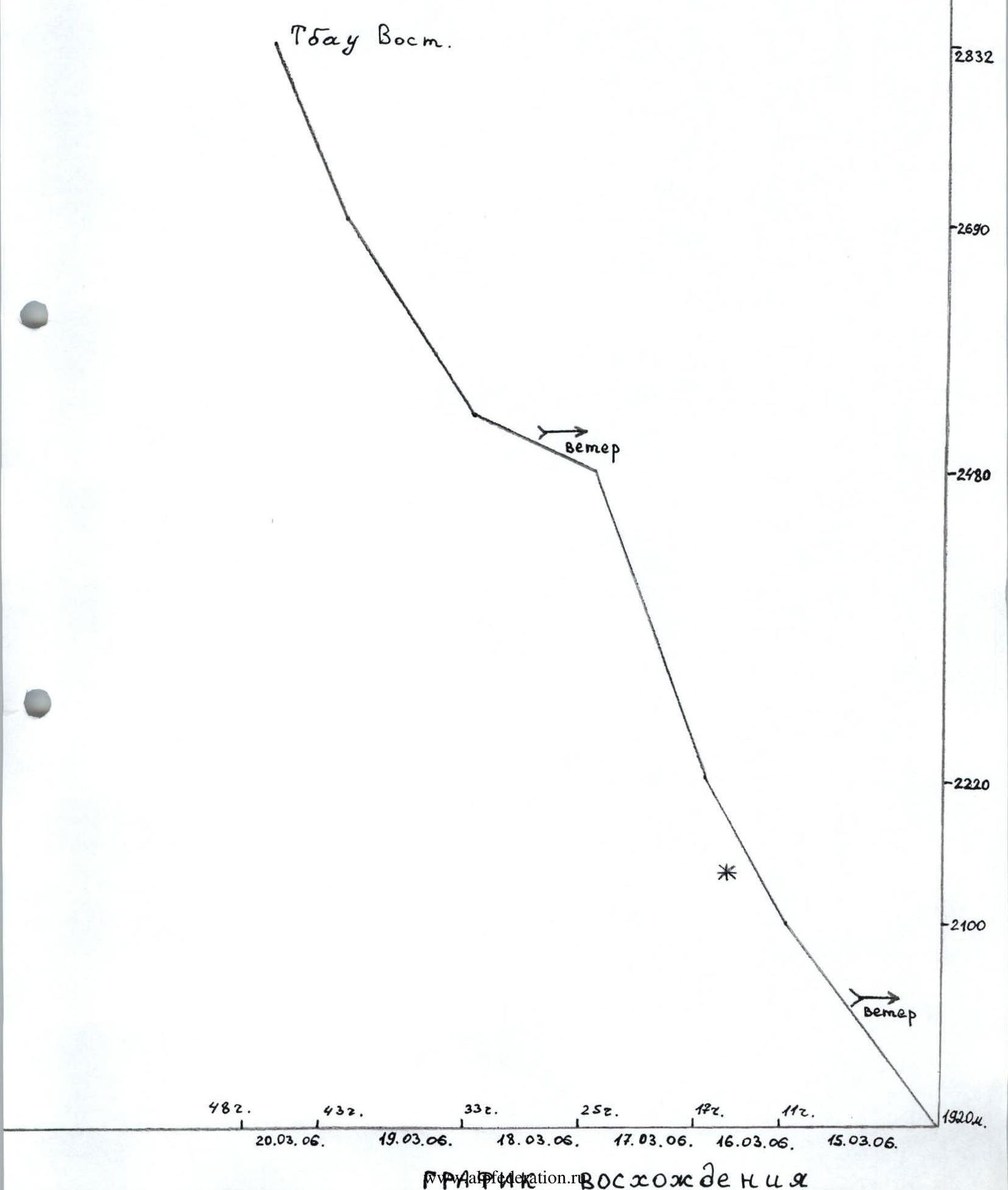
Reached the summit: 2:00 PM, March 20, 2006. Returned to base camp: 3:00 PM, March 22, 2006.
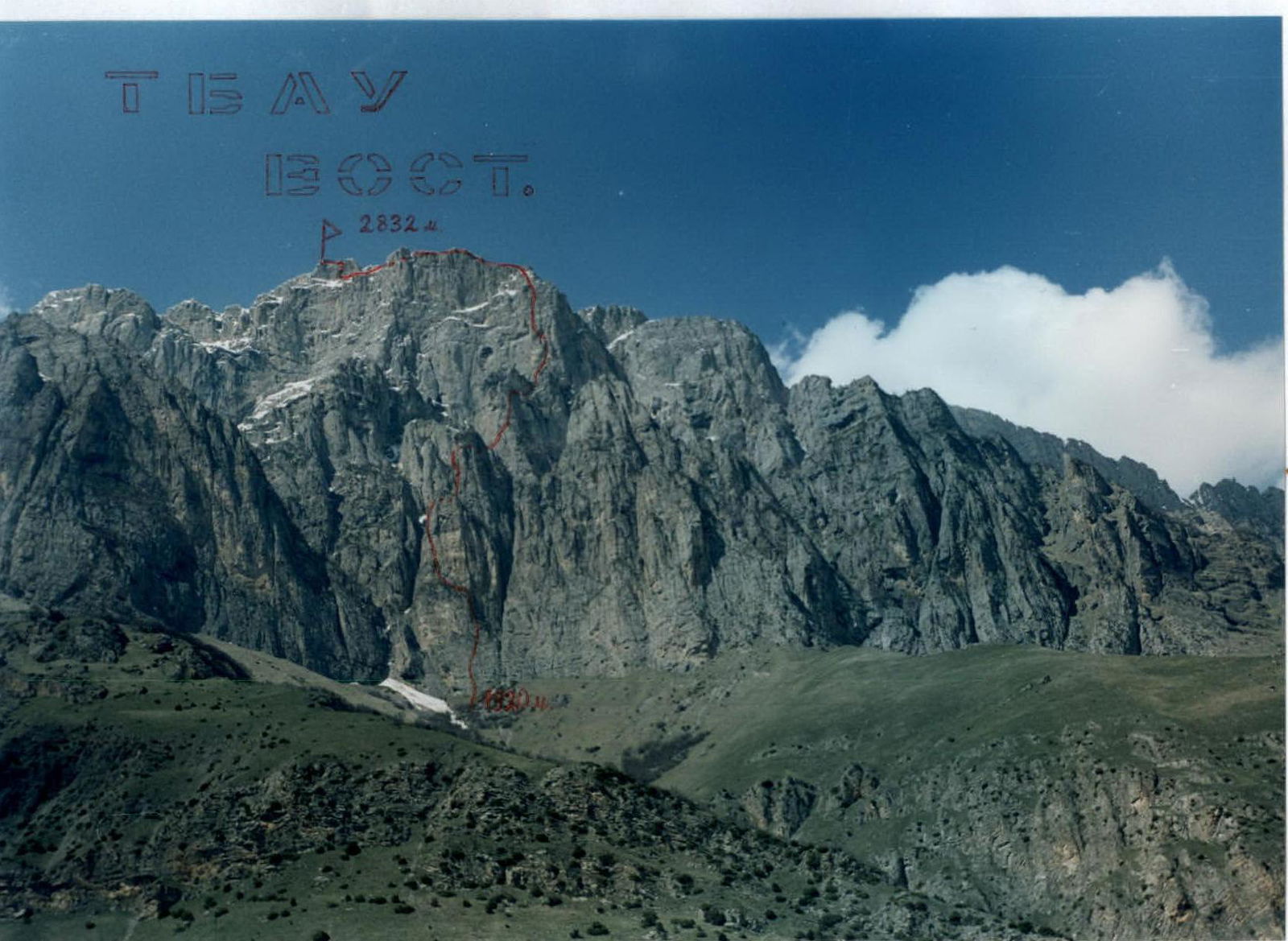
PHOTO 1. General view of Tbau - Eastern summit. View from the east. May 2003. Photo taken during the approach to the route. The first ascent route is marked.
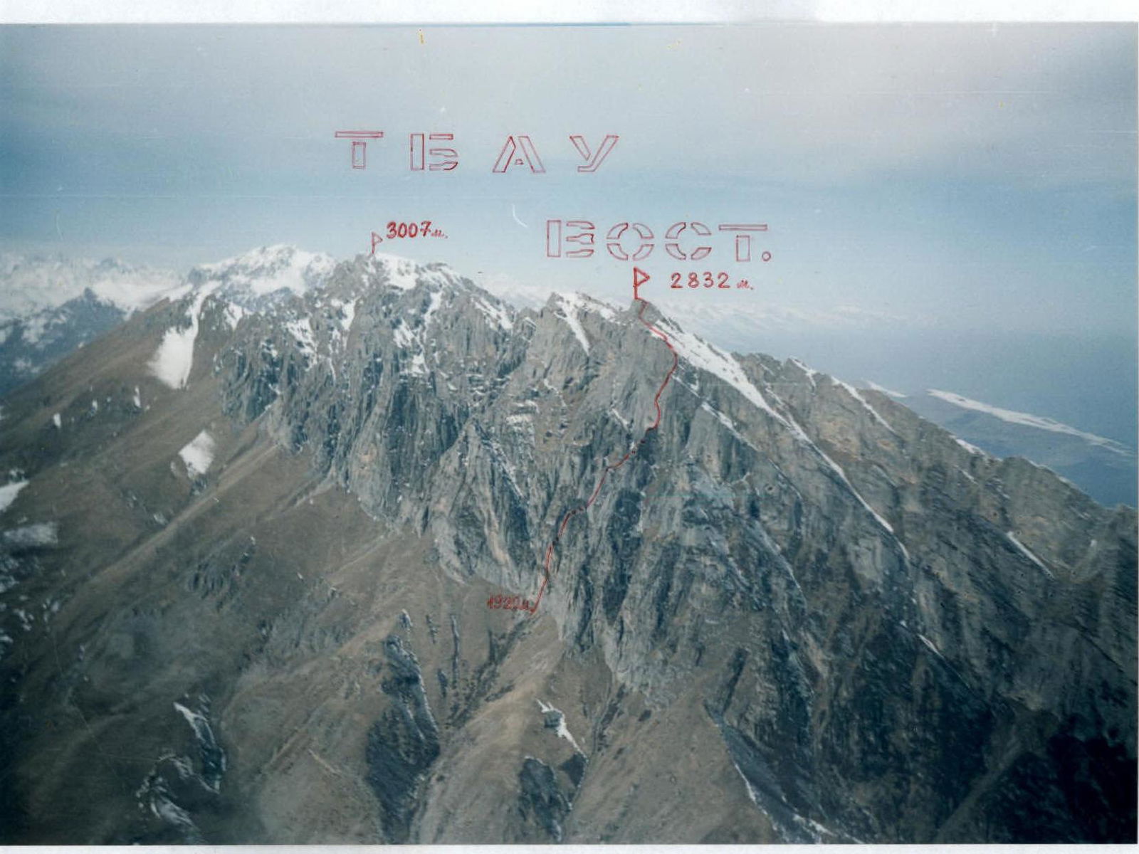
PHOTO 2. Route profile on the right. April. Photo taken from the summit of Chizhdjity-Khokh (2864 m).
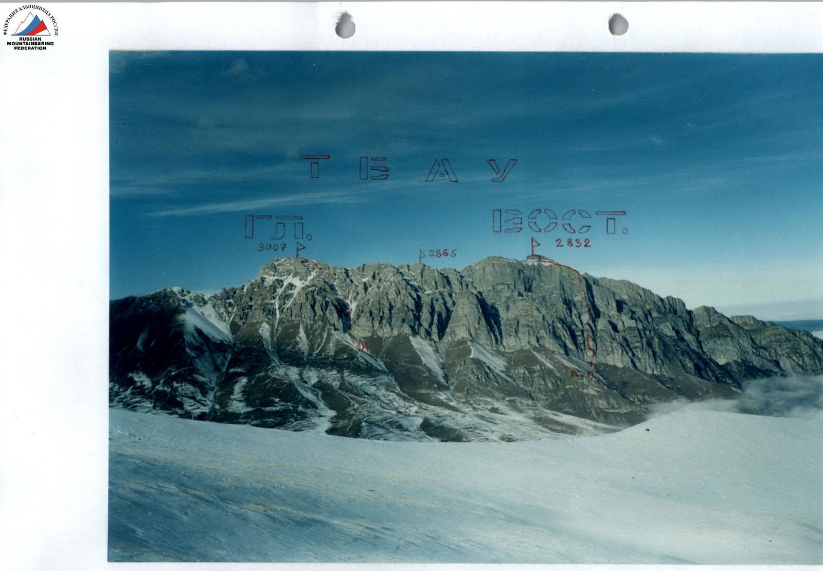
PHOTO 3. Photopanorama of the Tbau massif from the southeast, from the slopes of Pik Vladikavkaz. December. The first ascent route on Tbau Eastern is marked on the right, and the 1A category route on Tbau Main is marked on the left.
Overview of the Climbing Area
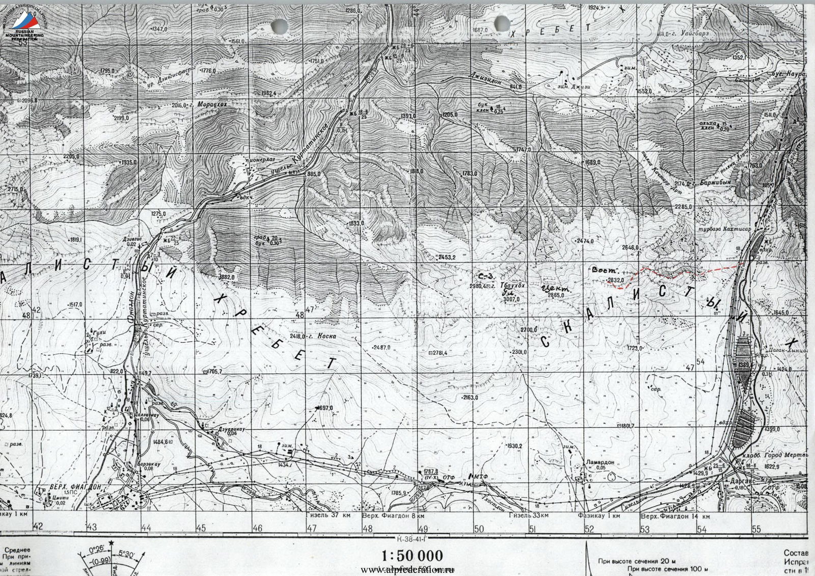
The climbing area is located in the Republic of North Ossetia — Alania, between the Fiagdon River to the west and the Gizeldon River to the east.
The Tbau massif is situated in the Rocky Ridge and stretches over three kilometers in the latitudinal direction.
The rocks composing the Tbau massif are of sedimentary origin:
- limestones,
- dolomites,
- calcites,
- and marble in some areas.
The cliffs are often monolithic, very steep, and without cracks. Like most peaks of the Caucasus Rocky Ridge, the Tbau summit is a typical escarpment, meaning it has relatively gentle northern slopes and steep southern slopes with rock faces. The highest point of Tbau is located in the western part of the massif at 3007 m. The ascent route to Tbau Main (1A category) follows the southeastern slope and begins from the Dargavs valley. Further east, about a kilometer away, along the ridge of the massif lies the Tbau Central peak (2865 m). There were no ascents to this peak until 2006. East of Central, about another kilometer along the ridge, lies the Tbau Eastern tower (2832 m). This peak drops off to the east with walls having a height difference of up to 900 m. The approaches from the north are long, which is why there were no ascents to it until March 2006.
Previously, mountaineering ascents on the Tbau massif were only made from the Kurtatinsky gorge (from the west) to the Tbau North-Western peak (2980 m), located in the northwestern spur of the Main peak.
In March 2006, a first ascent was made to Tbau Eastern via the eastern walls from the Dargavs valley. Due to the complex orography of the walls (gullies and chimneys cutting through the eastern and southeastern walls; lower bastions ending in 200–300 m drops into gullies), collecting photographic materials for the route took the last five years. According to geologists, such complex orography is a result of tectonic impacts.
The most optimal ascent route to Tbau Eastern was chosen:
- along the eastern ridge that leads to the upper southeastern bastion;
- then along the wall to reach the northeastern slope;
- the slope leads to the base of the summit tower from the south.
The southern slopes of the Rocky Ridge are in the so-called "rain shadow" zone. Here, the amount of precipitation is half that of the plain and 3–4 times less than in the high mountains of the Greater Caucasus. Even the vegetation shows signs of a mountain semi-desert. After snowfalls, snow doesn't lie for long in winter due to increased insolation.
Among the Ossetians, the Tbau peak is considered sacred. According to an ancient legend, it is the abode of Tbau-uats-Ila (St. Elijah of Tbau mountain).
Until now, every year in June, the village of Dargavs celebrates a festival in his honor.
Description of the Approach to the Route
From Vladikavkaz, drive to the village of Dargavs. Then continue down the valley towards the "Kakhtysar" tourist base. About 2 km before the tourist base, opposite the lowest dried-up trout lake, start ascending westward, up towards the walls of Tbau Eastern.
The ascent path follows a wide grassy ridge with rock outcrops. At the base of the ridge are semi-ruined ancient tombs. This ridge is to the right of a small gorge. The upper part of this gorge is closed off by the walls of Tbau Eastern. At the center of the gorge's end is the base of the Eastern ridge, which is the starting point of the route.
It takes about 1.5 hours to reach the walls along the grassy ridge. Then turn left and approach the base of the Eastern ridge. The ridge is separated from the rest of the massif by narrow chimneys-gullies (avalanches come down these gullies after snowfall) in the lower part; the chimneys drop off with walls up to 50 m.
Overnight at the base of the ridge, or move left upwards under the walls to a grotto (another 15 minutes). Near the grotto, it's more likely to find snow for water.
Route Description
R0–R1: The Eastern ridge is separated from the main rock massif by a deep chimney on the right. Under the base of this chimney is a small talus slope — falling rocks come down this chimney. To the left of this talus, about 20 meters away, is the start of the route.
- Up the gray wall towards a small grassy ledge visible ahead.
- From it, left — up onto slabs with small ledges (transition 2 m; 5+ category; 85°).
- Continue straight up (climbing is tense, few cracks for piton placement) to a large ledge with juniper.
The entire section: 45 m; 4+ category; 75–85°.
R1–R2: From the ledge, straight up through a small wall to another ledge (possible to bypass the wall on the right). Section about 25 m, 3–3+ category; 40–60°.
R2–R3: Then move right upwards through small walls (4 category; 70–80°) with ledges between them. Approach under an overhanging chimney that goes left with two steps (at the bends of the overhangs: grass and earth).
- Chimney: 5; 5 category; about 12 m; 80–95°.
- Entire section: 40 m.
R3–R4: Along the ledge left upwards under the wall about 50 m, 2 category; 20–30°.
R4–R5: From a small shoulder at the end of the ledge, start ascending up an internal corner. In the middle of the section — a 2 m wall, 5 category. Continue up the chimney left — upwards to a narrow small ridge.
- Entire section: 30 m; 4–4+ category; 60–85°.
R5–R6: From the ridge straight up the yellow rocks. After 7 m — an overhang: 2 m; 95°; 6 category; A1. Then enter a sloping chimney that narrows at the top. Initially, follow the center of the chimney, then its left edge. Above the chimney, exit onto a ledge with juniper.
- Entire section: 40 m; 5; 4+ category; 80–95°.
- In the chimney: 10 m; 5 category.
R6–R7: From the ledge, traverse left to the start of a wide internal corner, up it. Before a wall in the middle of the section, move right. Then go left upwards onto a shoulder of the 1st rise of the Eastern ridge, left of its summit.
- Section: 50 m; 60–80°; 4–4+ category.
R7–R8: From the shoulder left — down onto a ridge before the 2nd rise. Rappelling 10 m.
R8–R9: From the ridge right — up the wall 4 category; 70° to a chimney. Up the chimney 4–4+ category; 60–70° exit onto a ledge with juniper.
- Entire section: 30 m.
R9–R10: From the ledge up a monolithic overhanging crack 5 category; 95°; 10 m. Then up a wide internal corner, partly overgrown with grass, to its end — here move left onto the start of a grassy sloping terrace. Entire section 40 m.
Last 30 m:
- 4 category
- 70°.
R10–R11: Along the terrace traverse left 70 m; to its end.
Terrace:
- 30–60°
- 2–3 category.
R11–R12: From the end of the terrace left — up 10 m onto a small ridge, here turn right. Then up the wall right — upwards to the start of an internal corner, up it left upwards onto a shoulder of the 2nd rise left and below its summit. On the shoulder to the right under a rock is the 1st control cairn. Entire section 50 m; 60–80°; 4 category.
R12–R13: From the shoulder rappel 20 m onto a ridge before the 3rd rise. Overnight is possible here.
R, R13–R14: From the ridge 20 m along a grassy slope to approach under the start of the 3rd rise walls of the Eastern ridge. Here, right along a ledge 2 category under a 10 m wall. Up the wall 4+ category to exit onto a ridge — another 10 m; 70°. Then move right upwards towards a small ledge with juniper.
After the ridge:
- 30 m;
- 70–80°;
- 4+ category.
R14–R15: From the ledge right upwards bypassing a gray overhang. Then exit right onto a small ridge on the wall (exit 5 m; 5 category; 90°). Up the ridge (few cracks for piton placement) onto a ledge. Ridge 15 m; 4+ category; 80°. Entire section 45 m.
R15–R16: After reaching the ledge, we find ourselves to the right of the Eastern ridge line. Along this ledge on the north side of the ridge, we approach under a wall. Up its right side to exit onto a shoulder — from it, the southeastern bastion is visible ahead. From the shoulder left upwards onto the left side of the ridge. Section about 100 m. Wall 30 m; 4–4+ category; 60–70°.
R16–R17: Walls on the ridge line are bypassed on the left, along rocks 3–4 category. At the end of the section, exit onto the ridge line and through rock rises with steepness 70–80°; 4–4+ category approach under the base of the southeastern bastion (its right part). Entire section about 150 m. To the right under a rock in a niche on a piton — 2nd control point.
R17–R18: Left of the niche up a crack 5 m; 5 category; 85°, then a transition right 5+ category; 3 m; 90°; A1, with an exit onto a small ledge. From it up under an overhang, left of rusty cornice, 7 m; 5 category; 90°. Through the overhang (2 m; 95°; 6 category; A2). Exit onto a small ledge. From it up the wall to a ledge another 5 m (5 category; 85°). On the ledge is a piton. From the ledge up a monolithic slab 5 m; 90°; 6 category; A2 (sky-hooks) — enter the start of a crack.
Up the crack, partly destroyed, overhanging in the upper part, enter a chimney. Crack 10 m; 5+–6 category; 90–95°; A2.
Up the chimney (85°; 4+–5 category) and exit left onto a shoulder — piton. Entire section 50 m, its passage depending on the state of the rocks, takes 4–6 hours. Key section of the route.
R18–R19: From the shoulder traverse left under an overhang — 5 m; 4+ category; 80°. Then 3 m up; 5+ category; 90° and enter a small cornice. From it traverse left through an overhanging bend of the wall (piton on the bend), a psychologically tense place, and further into a small chimney. To the chimney 7 m; 5+ category; 95°; A1.
Up the cornice or its right side to a ledge with a piton. After the traverse 25 m; 80–85°; 4+–5 category. Entire section 40 m.
R19–R20: From the ledge right upwards along a wide internal corner, or its right side. Direction of movement — a visible overhead notch against the sky — an internal corner.
- In the middle of the section is an overhang 95°; 2 m; 5+ category.
- At the end of the section, exit onto a ledge with a piton under a rusty cornice.
Entire section 35 m; 4+–5 category; 80–90°.
R20–R21: From the ledge an overhang 2 m; 5+ category; 95°, then up an internal corner towards a gray "tooth" visible against the sky. After 40 m from the start of the section, approach a ledge to the right of the "tooth" under a slab. Here is a piton. Section 4+–5 category; 80–90°.
R21–R22: From the piton straight up. After 10 m; 4+ category; 85° exit onto a ledge, after 10 m along it — move through a 5 m wall 4 category to the right onto a ridge. Behind it is a large ledge, overnight stay is possible. Entire section 30 m.
R22–R23: Along the ridge, through a chimney 70°; 4–4+ category exit onto a ledge. Another 30 m.
R23–R24: From the ledge, first right of the ridge line, then along its left part, exit over the wall's bend onto the northeastern slope of Tbau Eastern. Rocks on the section 3–4 category; 50–70°. Section — 40 m.
R24–R25: Along the northeastern slope, move left, to the west. Walls are bypassed on the right (with a lot of snow, it's avalanche-prone). After about 300 m, approach along the talus under the middle of the southern wall of the summit tower. Here is a chimney. Section 1–2 category; 20–40°.
R25–R26: Up the chimney 20 m, then left onto the northeastern ridge of the summit. In the middle of the chimney is an overhang — 3 m; 95°; 5 category. To the ridge 50 m.
R26–R27: Along the ridge 2–3 category, move west about 70 m, to the end of the tower. Here is the summit cairn. The summit — a good panoramic point.
Descent:
- Along the northeastern ridge (about 2 category), but with a lot of snow on the northern slopes, it's avalanche-prone.
- Or along the ascent route.
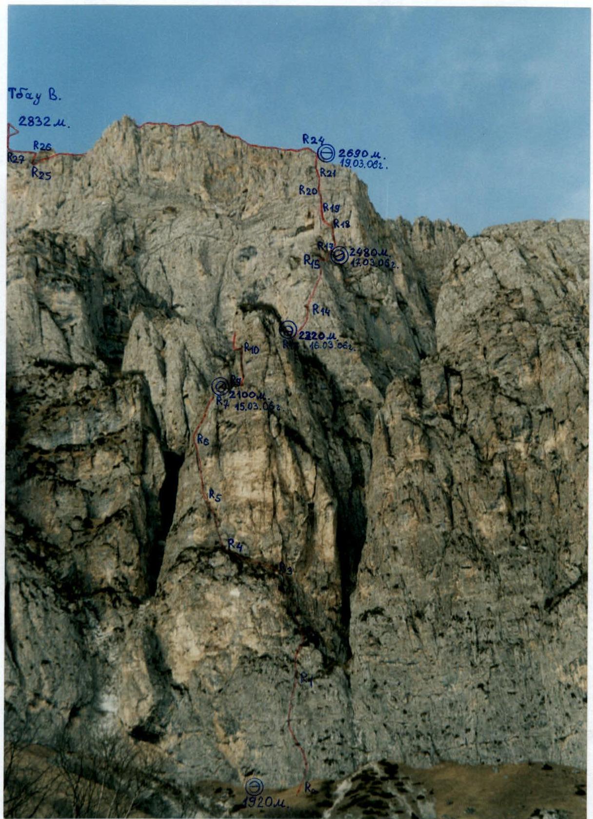
PHOTO 4. Technical photograph of the route. December. The route line is marked on the photo (its visible part), section numbers are indicated, heights are determined by GPS, and overnight locations are marked.
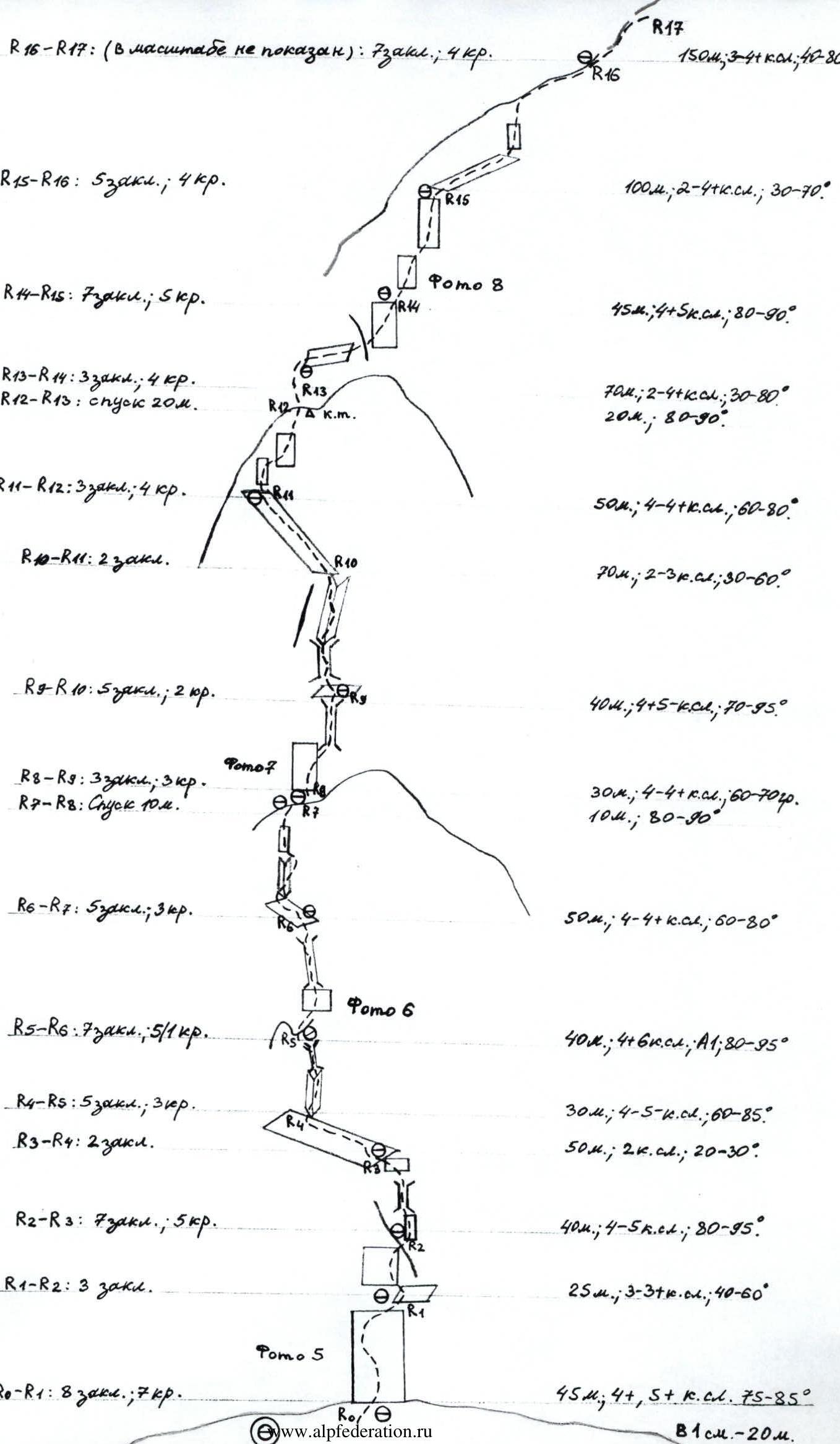
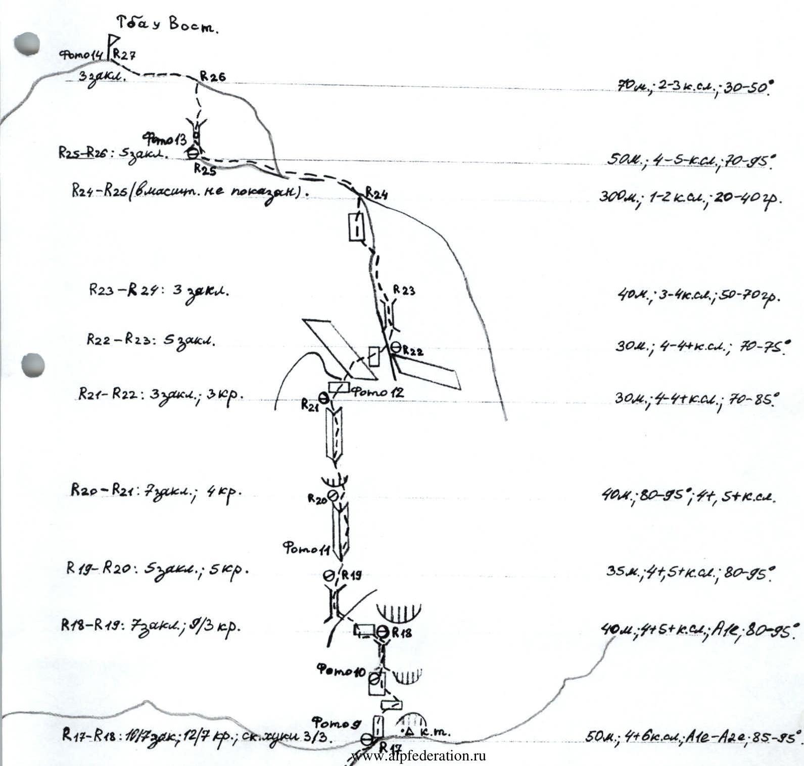

PHOTO 5. Moving along the ropes in the middle of section R0–R1.
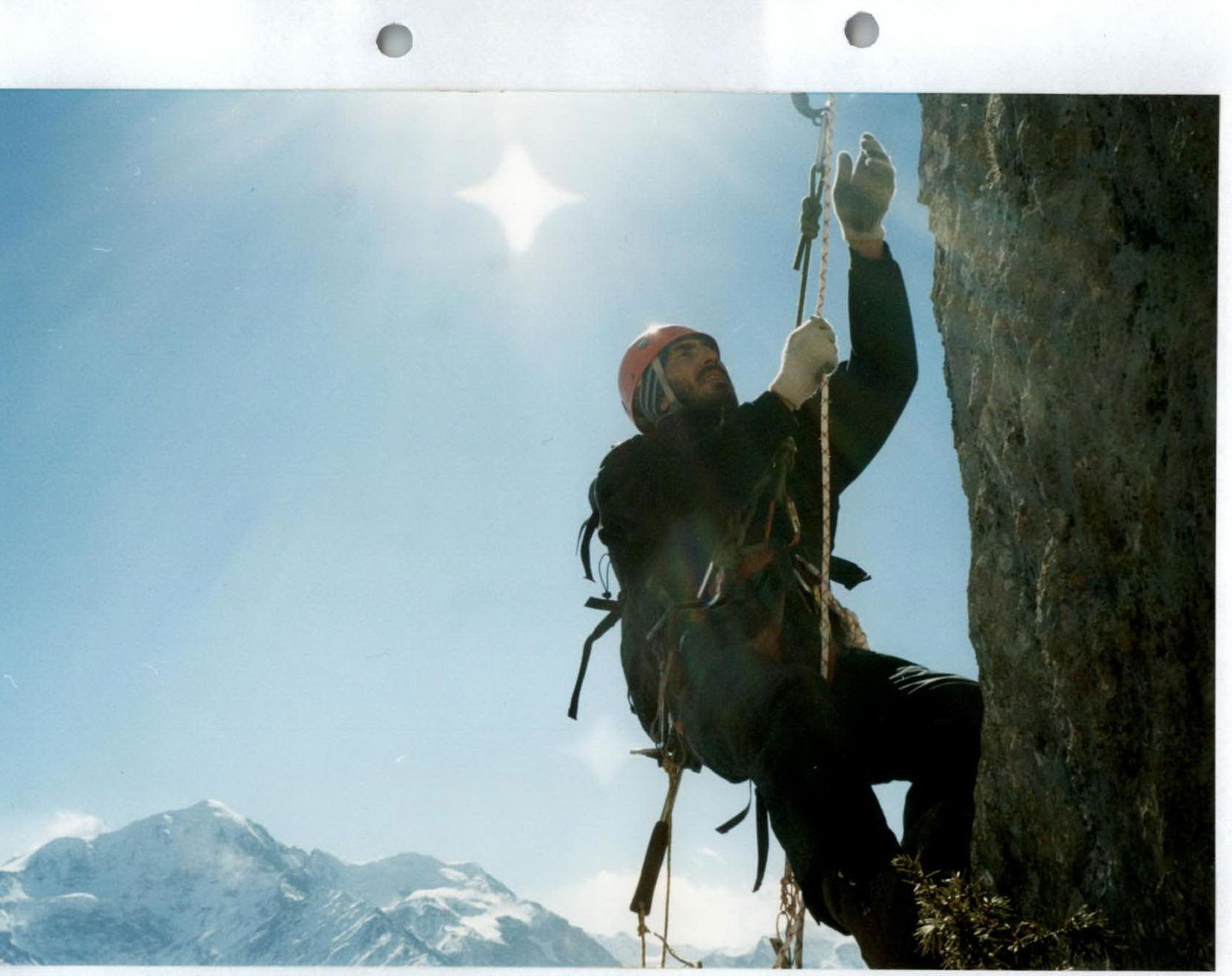
PHOTO 8. Moving along the ropes at the start of section R14–R15 (Third rise). In the distance, the summit of Shau-Khokh (4636 m) is visible.
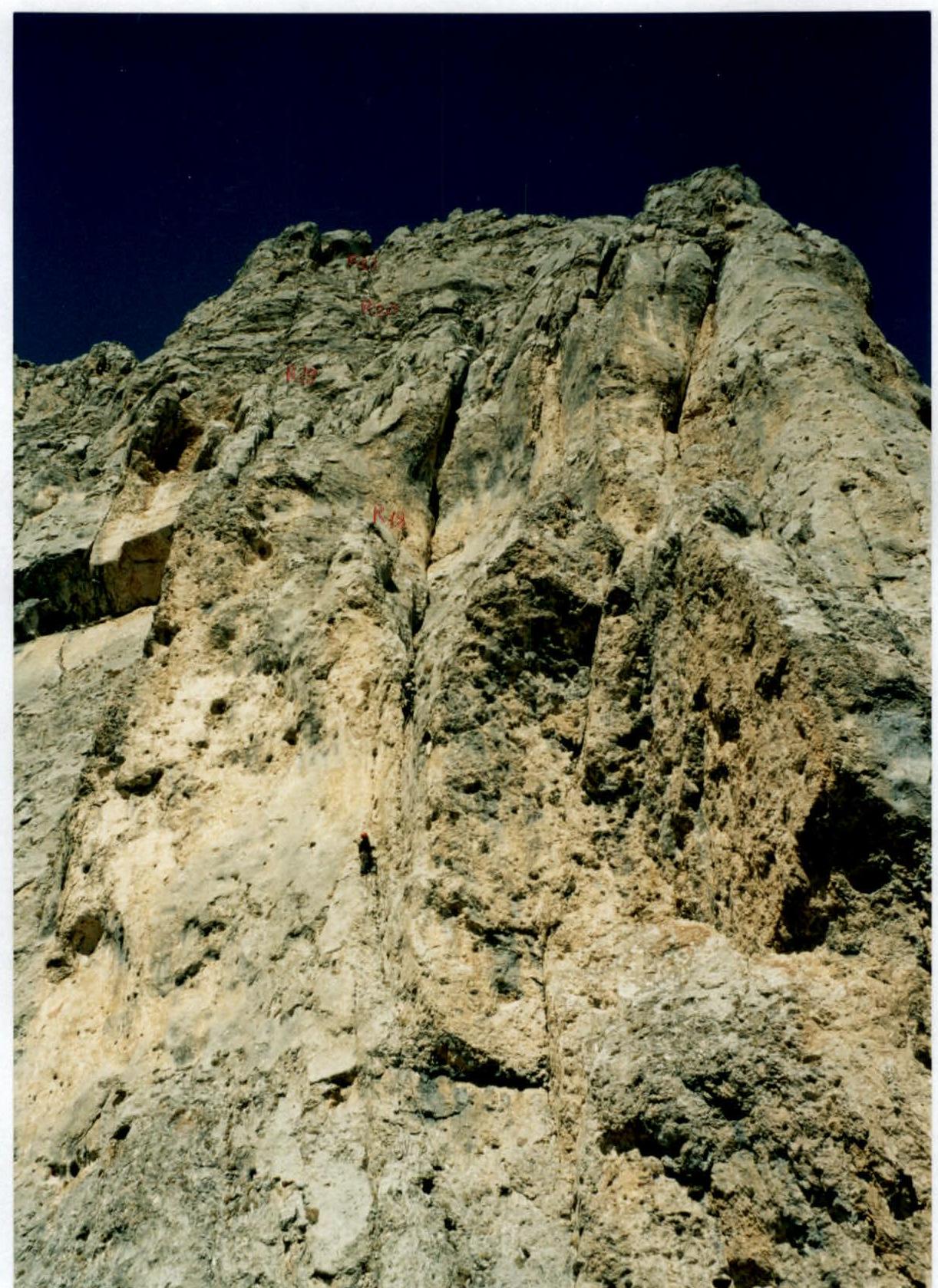
PHOTO 10. Passing the upper part of section R17–R18, at the start of the upper chimney. Photo taken from the base of the bastion.
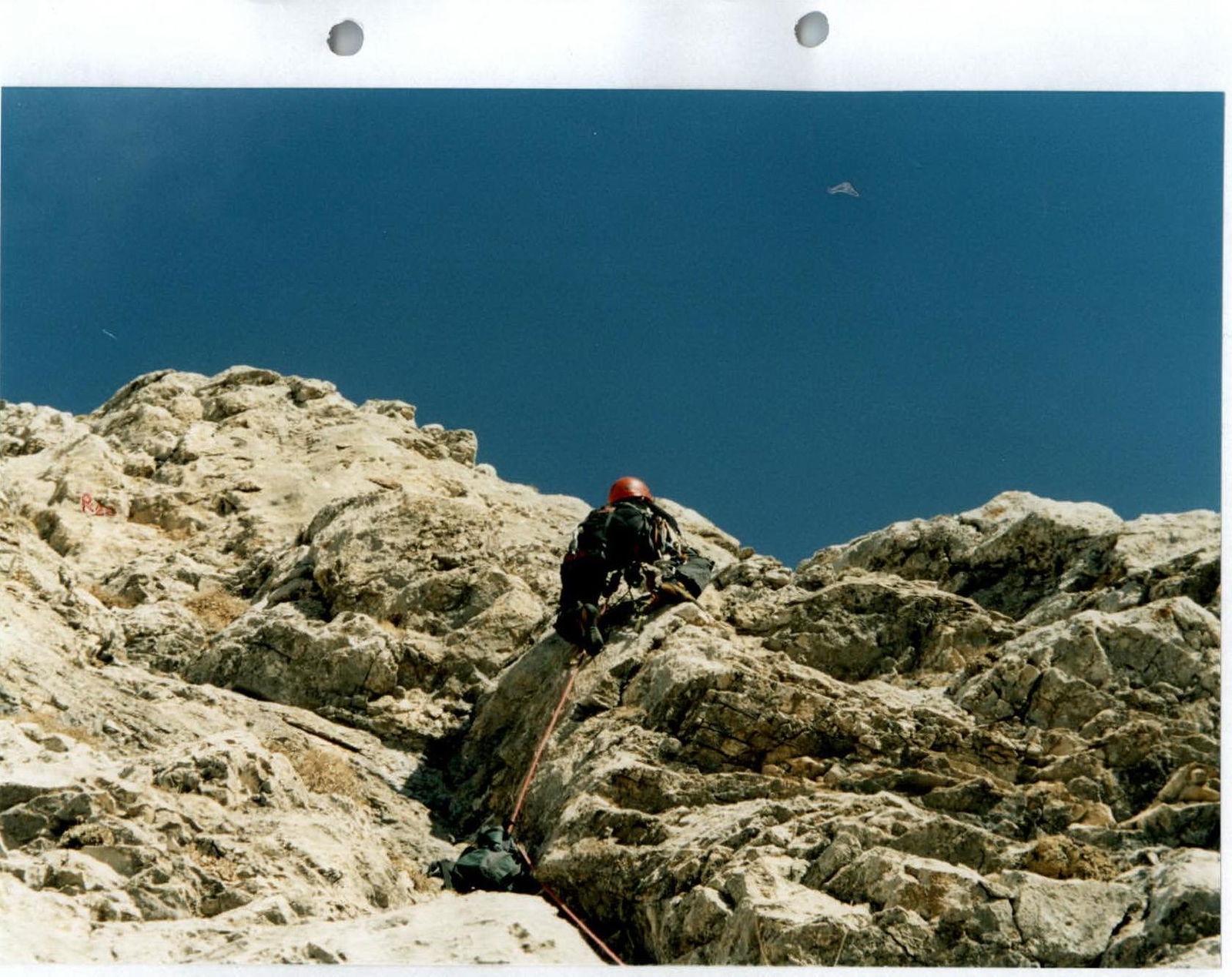
PHOTO 11. Passing the overhang in the middle of section R19–R20.
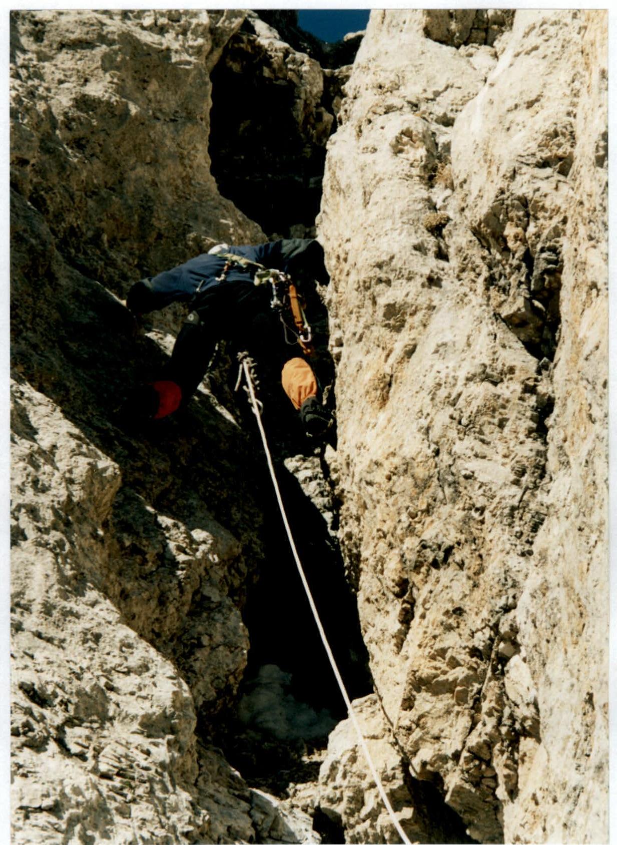
PHOTO 13. Reaching the summit tower. Passing the chimney. Section R25–R26.
Conclusions and Recommendations for the Route
The route we've completed, in our opinion, corresponds to the 5B category based on the number and complexity of its key sections.
The route's height difference is 912 m. Route length: 1550 m. Length of sections with 5 and 6 category: 135 m. ITO used — 21 pcs. (they were necessary, despite the fact that most of the key sections were climbed in rock shoes, effectively on dry rocks).
The route is recommended to be climbed from November to May when there is snow on the approaches and on the route (on ledges) for water. Although it's often the case that after long periods of good weather, the route can be dry even in winter.
In addition to regular pitons and nuts, it's necessary to have:
- friends,
- piton hangers.


