Route Description
Ascent to Peak 25-letiya Severnoy Osetii (Syrkhu-Barzond) (4051 m) via the northern ridge, category 3A.
The summit is located in the northwestern spur of a lateral ridge branching off from Tsarint-khokh and represents an independent massif of the spur.
The northern ridge of the summit was climbed in 1949 by a group of North Ossetian alpinists.
To the west, a steep ridge extends, still unclimbed and estimated to be category 3-4.
To the north, into the Kurtatinsky gorge, towards the village of Khidikus, descends a ridge that was climbed for the second time by groups of the North Ossetian DOSAAF "Spartak" on May 29-30, 1964 (a group of 1st category and 2 groups led by 1st category).
The height difference from the Kurtatinsky gorge to the summit is 2500 m. The route length is approximately 7 km. The main technical work takes place at an altitude of 3300-4051 m above sea level.
The path from the village of Khidikus goes along a wide ridge. Initially, it's a steep grassy slope with many trails. Further, the path goes along slopes overgrown with subalpine mixed forests.
Higher up, at an altitude of 2300-2500 m, grassy slopes reappear, overgrown with rhododendrons. Overnight stops are possible here (lack of water in summer). The journey from the village of Khidikus to the overnight stop takes 4.5-5 hours.
Further up, slightly along the slopes, and exit onto a wide, clearly defined ridge, overgrown with grass, with rock outcrops. On the ridge, there's a large "gendarme". The journey from the overnight stop to the "gendarme" takes 2-2.5 hours; the "gendarme" (section DE) should be bypassed on the left along the route if there's snow on the steep snowfield. Belaying is done through an ice axe. In summer, when there's no snow (avalanche danger!), it's possible to bypass to the right (along the route) on steep "live" scree. However, this involves losing altitude. Before the "gendarme", it's necessary to rope up.
From the "gendarme" upwards, there's a steep rocky ascent with outcrops of medium complexity rocks, covered in snow. Belaying is simultaneous and alternate. At the end of the ascent, there's a 40 m wall (pitons). For large groups, it's recommended to use ropes. The journey from the "gendarme" to the wall takes 2 hours.
After the wall, the ridge becomes gentler and consists of many low "gendarmes" (2-3 m). They are climbed "head-on". The rocks are easy and moderately difficult. Alternate belaying is mandatory. There are cornices. The journey along this ridge takes 1 hour.
Further, the ridge drops down steeply (it's necessary to hang ropes - 1 rope - for a quick descent; the total drop is 80-120 m) and transitions into a long, moderately steep pre-summit ridge. The ridge is covered in snow, with rock outcrops. In its upper part, the ridge turns into a pre-summit ice dome, covered in snow, with a steepness of 25-30° (pitons!). The journey from the drop to the summit takes 4-5 hours.
The descent should be done along the ascent route. The descent to the road takes 8 hours.
Recommendations for Climbers
- Group size not more than 6-8 people. For a group of 4 people:
- 30 m x 2 main ropes.
- 5 m x 2 auxiliary ropes.
- Carabiners - 8 pieces.
- Rock pitons - 6 pieces (with long blades).
- Ice pitons - 2 pieces.
- Hammers - 2 pieces.
Assessment of the Difficulty Category for the Ascent to Syrkhu-Barzond
Taking into account the experience of previous ascents and comparing this ascent with ascents to other summits, it's necessary to correct the existing category 2A to 3A.
The description was compiled by:
 (D. Shevchuk)
(R. Proskuryakov).
(D. Shevchuk)
(R. Proskuryakov).
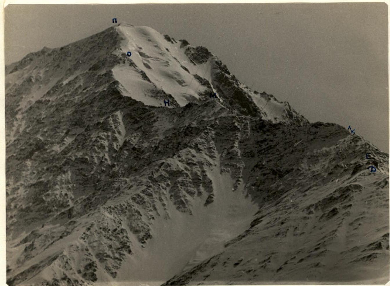
Peak 25-letiya SOASR (Syrkhu-Barzond) 4051 m.
Route along the northern ridge
telephoto by R. Proskuryakov
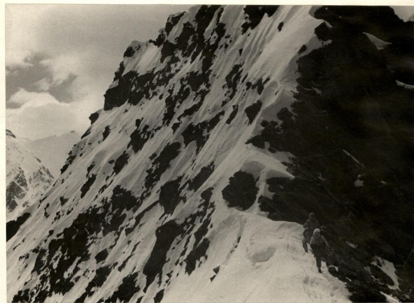
On the ridge of Syrkhu-Barzond before section K-L