South Kaidzhany (3916 m)
Peak of the Kazbek Highland Region
The peak South Kaidzhany is located between the peaks North Kaidzhany and Peak "3850 m" of the Eastern Lateral Ridge, north of the Kazbek massif. The peak has been visited repeatedly since 1947 by mountaineering groups from Ordzhonikidze.
Most popular routes:
- Via the Northeast Ridge
- From the south, from the Chach gorge
Below is a description of both routes:
- Description of the ascent route to South Kaidzhany via the Northeast Ridge
- 1B-P-A-cat. diff.
Day 1. From Ordzhonikidze, the group arrives by car in 1 hour to the village of Gvileti, from where they ascend on a wide pack trail for 1 hour to the confluence of the Amali and Chach-khi rivers.
After crossing the rickety bridge over the Amali River and overcoming the steep ascent of the trail, they proceed along the trail into the right (Chach) gorge.
The trail crosses to the left (orographic) bank of the Chach-khi River, where it becomes less distinct.
Gradually gaining elevation along the slope, they reach the "sheep's foreheads" (baranie lby).
After overcoming the "sheep's foreheads" via one of the shelves dissecting them, they need to ascend along the grassy slope under the cliffs, where the trail is well-trodden. Moving along the cliffs, they reach a shoulder forming the first "gates" of the gorge:
- From the confluence of the rivers to the saddle point of the first "gates" is a 1 hour 30 minutes walk. The "sheep's foreheads" are traversed with caution using gymnastic belay.
Along the trail that traverses the grassy slopes and a series of scree couloirs, they reach the second "gates" in 50 minutes, which represent a rocky defile in the river floodplain.
They descend to the "gates" via scree. The "gates" can be passed on the left (orographic) slope of the gorge or directly in the defile near the river. On the right (orographic) bank of the river, before the second "gates", there is a convenient terrace where they can set up a camp.
When crossing the river before the second "gates", it is advisable to continue further to reach the expansion of the river floodplain before the third "gates" in 40 minutes, where a convenient bivouac can be set up.
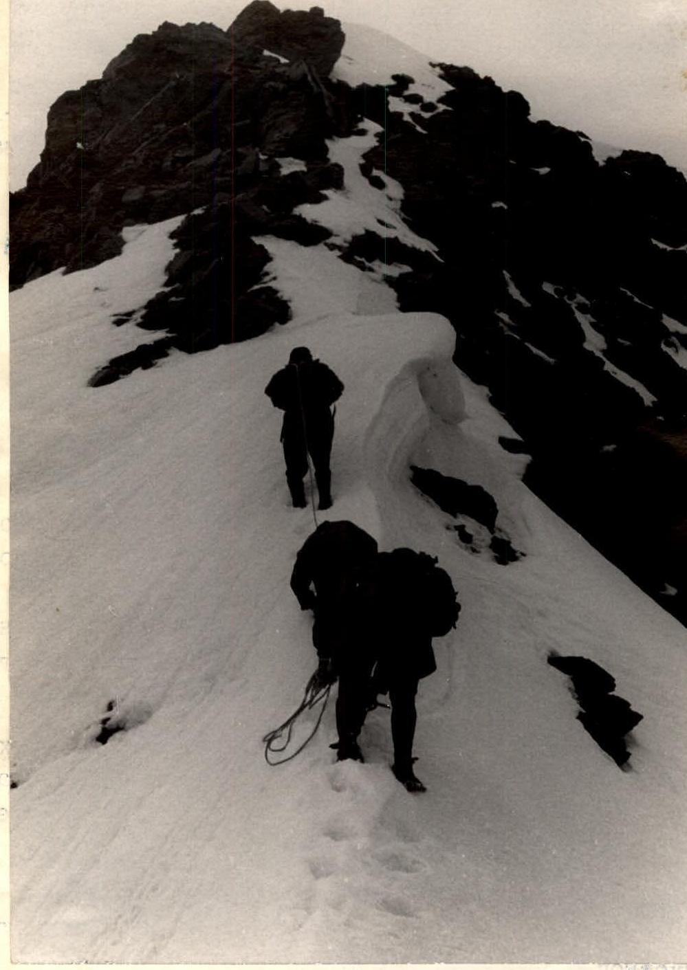
 A rope team is making its way along the Northeast ridge of South Kaidzhany. Photo by R. Proskuryakov.
A wide trough-shaped couloir descends to this location, originating from the trough of the Kaidzhany glacier.
Day 2. Departure not later than 5:00. They ascend along the slope, leaving the mentioned couloir on the left. After the grassy slopes, they climb up the scree, emerge onto a hill of the ancient terminal moraine of the glacier, and enter the glacier cirque. They ascend along the calm glacier in rope teams to the ridge col between the South and North Kaidzhany massifs.
From the col, they need to turn left and move along the ridge leading to the South Kaidzhany peak. The ridge soon becomes narrow. In places, it is a snowy "knife-edge", and in others, a sharp, fragmented slate ridge with individual ascents.
Belays are alternating. After 2-2.5 hours of work, they climb onto the smooth slabs of the sub-summit, followed by:
- a 30 m deep notch in the ridge;
- then a 50-meter wall - the ascent to the summit tower of South Kaidzhany.
Belays are placed through rocky outcrops and ledges. The rocks are extremely fragmented, requiring caution!
This is the most challenging section of the route. From the sub-summit to the summit is approximately 1.5 hours of work.
The summit tower is composed of fragmented slate rocks. The descent from the summit initially follows a wide, fragmented rocky ridge to the west for 100 meters, then 200 meters along simple rocks, scree, and snowy slopes to the south, towards the Chach gorge. After descending to the South spur of South Kaidzhany, they need to turn left into a snowy couloir with a rocky outcrop in the middle, with a slope of 45°. The outcrop is bypassed on the left. The length of the couloir and subsequent slope is 300 meters. The slope gradually becomes gentler.
Turning east, the hanging valley leads to the terminal step in the upper trough of the Kaidzhany glacier. The descent is along live scree of medium size - 150 m, and further, the descent route coincides with the ascent route into the Kaidzhany glacier trough.
The descent is via route 1-B-P-A cat. diff. to the Chach gorge.
- The descent from the trough to the Chach gorge takes 1 hour.
- The descent from the bivouac to the village of Gvileti takes 2-2.5 hours.
- From there, it takes 1.5-2 hours to return to Ordzhonikidze by car.
Equipment recommended for a group of 4
- Main ropes 30 m - 2 pieces.
- Rock pitons - 10 pieces.
- Group carabiners - 7 pieces.
- Hammers - 2 pieces.
Description of the ascent route to South Kaidzhany from the south
1-B-P-A cat. diff.
Day 1. The route on Day 1 and the ascent to the Kaidzhany glacier trough completely coincide with the previous description. The bivouac location is before the III "gates" of the Chach gorge.
Day 2. Departure not later than 5:00. They ascend along the slope, leaving the mentioned couloir on the left. After the grassy slopes, they climb up the scree, emerge onto a hill of the ancient terminal moraine of the glacier, and enter the glacier cirque.
From the Kaidzhany glacier trough, the South peak massif is clearly visible, dissected by a hanging valley. They need to turn west and overcome the steep and loose 150-meter terminal step of the hanging valley. Following the valley (deep snow), they reach its upper part and ascend along a wide snowy slope (increasingly steeper), narrowing into a bifurcated couloir, with a slope of up to 45° in the upper part. Movement along the slope and couloir is in rope teams. There is a risk of rockfall from above. Adhering to the rocky massif dividing the couloir, they bypass it on the right, emerging onto its "roof" with piton belays.
From the outcrop, they turn left and ascend along the snowy slope, which becomes increasingly gentle and leads to the South slope of the South peak. The 200-meter long slope is snowy, with fragmented rocky outcrops, and leads to the summit ridge. They proceed along the wide, fragmented ridge for another 100 meters to the east to the highest point of the massif.