
The peaks of Jimarai-khok (4776 m), "4398" and Soutisi-khok (4473 m) are located west of the peak Kazbek in the spur of its snowy massif and limit the Midagravin plateau from the east and southeast.
Jimarai-khok is the highest peak in the mountains of North Ossetia. Its icy-rocky northern wall is clearly visible in clear weather from the city of Ordzhonikidze between the white caps of Kazbek and Shau-khokh (4000 m).
The peaks of Jimarai-khok, "4398" and Soutisi-khokh are composed of schists cut by diabases and effusives, and have significant glaciation. The western rocky ridge of Jimarai consists of effusive rocks.
The first ascent to Jimarai was made by a group led by Z. Japaridze in 1935 via the western rocky ridge.
In subsequent years:
- In 1950, climbers from the "Medik" Sports Society of North Ossetia visited Jimarai again.
- In 1955, a group from the North Ossetian alpine section led by Suzhaev traversed the peaks of Jimarai-khok - Shau-khokh, which was rated as a category 5B route.
- The peak Soutisi was first conquered by a group led by S.V. Polyakov in 1956 via a ridge ascent from the Tep pass.
No one has ever been to the peak "4398", which remains nameless.
The beauty of the Jimarai, Soutisi peaks and the snowy-icy ridge with cornices and icicles between them prompted the climbers from the "Lokomotiv" Sports Society to undertake this traverse, which is described below.
Day 1
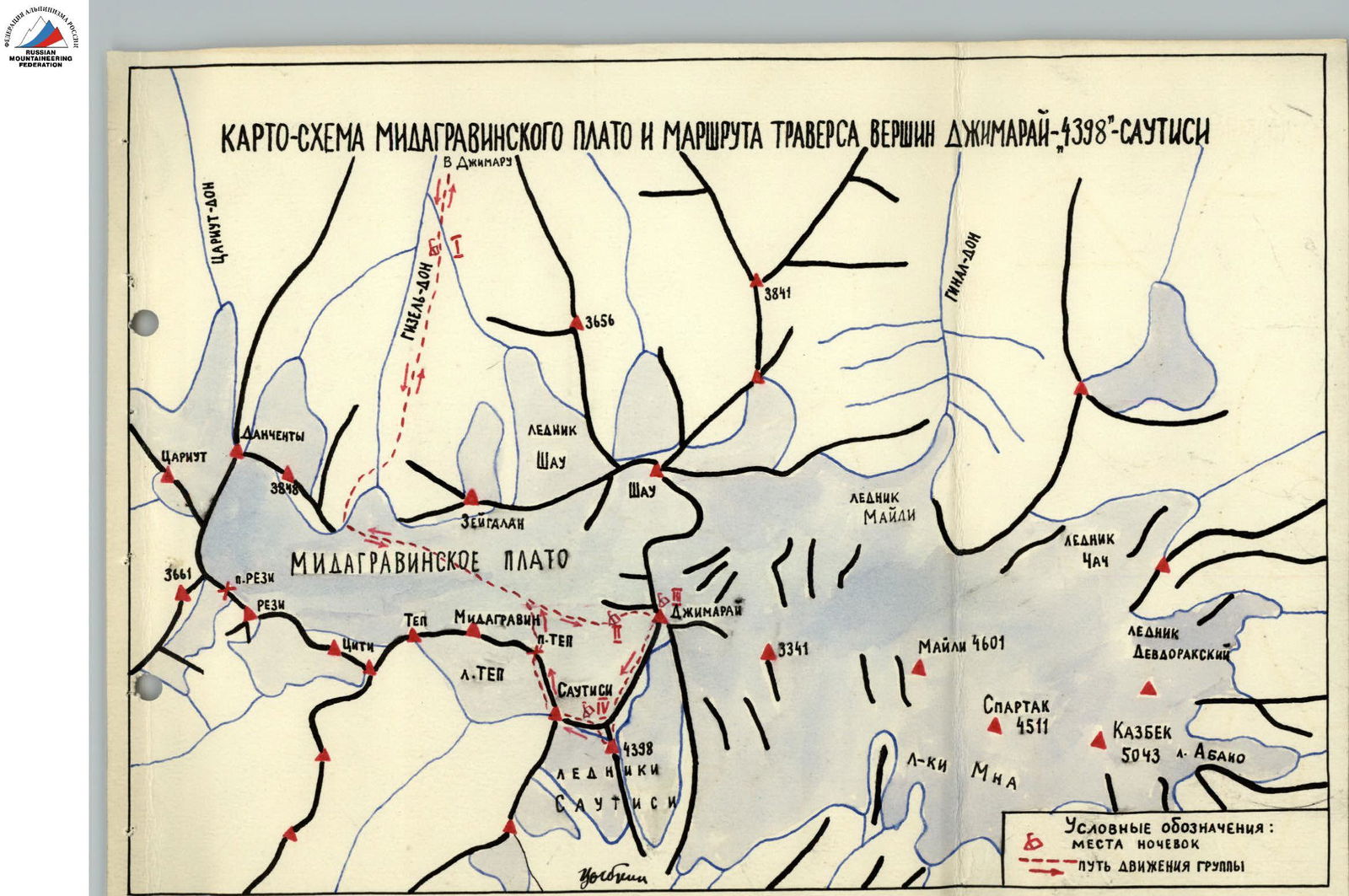
The group left the city of Ordzhonikidze by car through the settlements of Gizel, Koban to Bremsberg (a rail-mounted cable car). The distance from Ordzhonikidze to Bremsberg is 30 km. After ascending 250 m on Bremsberg, the group traveled another 14 km by car through the village of Dargavs to the village of Jimara. From Jimara, cars do not go further up the gorge, and we walked 7 km along a mountain road to the "Ram's Foreheads" located at the foot of the Zeigalan-khokh peak, where the Gizeldon River flows from the tongue of the Midagravin glacier into the valley. Here, we set up a night camp (1). This journey took the whole day.
Day 2
The group follows a trail on the right orographic bank of the Gizeldon River. We ascend along the trail to the "Ram's Foreheads" and then, reaching the tongue of the glacier descending from the "Ram's Foreheads", we cross it with the aid of step-cutting and move to the left side of the gorge. The width of the glacier tongue in its narrow part is 20 m, and the slope is 30°.
Further:
- We follow the "Ram's Foreheads" and talus, bypassing the steeply falling glacier tongue;
- We reach the Midagravin glacier.
The Midagravin glacier:
- is even, with a slight slope;
- is wide;
- initially flows from Jimarai from east to west;
- then turns sharply south, bypassing the Zeigalan-khokh peak.
Our path continues along the glacier towards the western rocky ridge of Jimarai. When we level with the peak Midagravin, we rope up into teams because the glacier has many open and snow-covered crevasses. Approaching the talus that marks the beginning of the western ridge of Jimarai in its lower part, and then ascending the talus for 500-600 m to the "Balda" rock, we set up a bivouac (P). The total duration of the day's journey is 10-11 hours.
Day 3
We left the bivouac at 5:00. The weather was good, but small clouds appeared in the west. The weather in the Caucasus has been poor all summer, but we have been lucky for all three days of our journey. Encouraged by this, we hope that good weather will accompany the entire ascent.
We first ascend along the talus, which is fine and slippery underfoot, along a stream on the right (300 m). The slope of the talus reaches 40°. We pass through the talus to the snow, turn left, and ascend along an icy couloir (R1) with boulders frozen into its bed, which is 25 m long and has a slope of 45-50°, using alternating belay.
Our path then follows the ridge (R2), which consists of moderately difficult rocks (of effusive origin) interspersed with icy-snowy sections. The slope of the rocks in some places reaches 60-70°, and that of the icy-snowy sections - up to 45°. Alternating belay is mandatory on the rocks and ice, and we traverse the ice on crampons. We follow the ridge, bypassing small "gendarmeries" on the right and left.
Finally, after overcoming a steep (45°) icy section (the ice is covered with a 5 cm layer of snow) 100 m long (R3), we approach the base of the first rocky wall. The icy section is traversed on crampons with piton belay (one ice piton and one rock piton).
The first rocky wall is about 100 m long and has a slope of up to 60° (R4). We overcome it with piton belay (two pitons).
Then, we approach the second rocky wall (R5), which is steeper and 150 m long. A narrow ridge 5-7 m long leads from the first rocky wall (R4) to the second. The path up the second rocky wall goes straight up. After hammering in 4 rock pitons and ascending the wall, we emerge onto the ridge of Jimarai to the left of the summit (in the direction of ascent).
At the top of the wall on the ridge, there is a wide and gentle icy depression protected:
- from the west and south by rocks;
- from the east and north by snowy-icy drifts.
After cutting a platform in the ice, we set up a bivouac (III). The passage of the day's section (from bivouac (P) to bivouac (III)) takes 9-10 hours.
Day 4
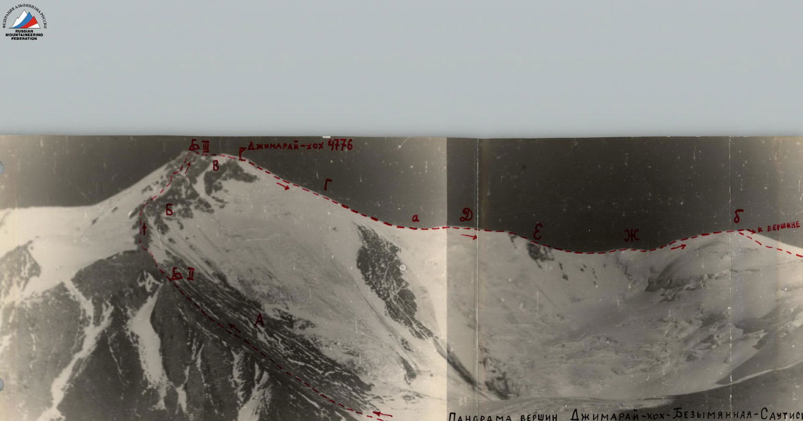
From the night's halt, the path follows a snowy-icy ridge with cornices to the east. The west side drops away into a wall. On the ridge, we encounter two icy walls (a photograph of the ridge is attached):
- One wall is 15 m high with a slope of 60° (section R6 on the photograph);
- The other has a slope of 50° (section R7).
After overcoming these walls using front-pointing and step-cutting, we emerge onto a wide ridge, along which we approach the summit (R9). We must be very cautious when walking along the ridge, avoiding a huge cornice that overhangs the western side from the summit ridge. The journey from the night's halt to the summit takes 1.5 hours.
From the summit, a very beautiful view opens up. To the east, the icy massifs of Kazbek, Maili, and Spartak tower. Far below lies the Midagravin glacier. Unfortunately, the weather is deteriorating, and nothing is visible further. The peak Soutisi and the ridge between Jimarai and Soutisi are already shrouded in fog. A thick veil of clouds is approaching from the southwest. However, the sky above Jimarai is still clear. We need to hurry to descend onto the ridge before the path becomes obscured.
The descent from the summit follows a snowy-icy ridge (section RG) with a slope of 40° straight down to rocky outcrops, and then along them - downwards. The slope is icy. The ice is covered with a thin layer (up to 10 cm) of powdery snow in some places. We descend on crampons with alternating belay on pitons (5 ice pitons were hammered in during the descent). A strong gusty wind hinders our progress. Eventually, the ridge becomes more gentle. The total descent is about 500 m long.
Further, we follow a gentle, icy ridge with small changes in elevation (section RD). Everything around is shrouded in fog, with visibility no more than 30-50 m. We have to walk in crampons. The ridge has cornices on the east side, while on the west, it drops away with a steep icy slope. After 300 m, the ridge becomes as sharp as a knife, without cornices. We walk directly along the "blade" of the ridge. The ridge is icy, with a slight dusting of snow.
After walking 300 m, we emerge onto a heavily destroyed schistose ridge (section RE):
- To the east, schistose walls drop away;
- To the west, there is a steep, up to 70-80°, icy slope.
The rocks on the ridge are very destroyed and crumbly, making the ridge very sharp and dangerous. Careful belay is mandatory. In some places, we have to "ride astride" the ridge. "Gendarmes" on the ridge are overcome "head-on". After traversing this rocky ridge, about 200 m long, we emerge onto a sharp snowy-icy ridge (section RF) with small changes in elevation, about 400 m long, which leads to the nameless peak "b".
The ridge is unpleasant, sharp, with cornices alternately on the west and east. We have to walk 0.5-1 m back from the edge along a steep, icy slope that becomes even steeper further down.
From peak "b" to peak "4398", a sharp icy ridge with small cornices leads. This ridge is traversed in 40 minutes. Peak "4398" is composed of destroyed schistose rocks. A rocky ridge extends from it to the east.
We descend from peak "4398" by the same route we ascended to peak "b", and from there, we descend along an icy-firn slope with piton belay (2 ice pitons were hammered in) to the saddle between peak Soutisi and the nameless peak. This descent is about 400 m long with a slope of 35-40°.
On the saddle, we set up a night camp on rocky outcrops (IV). The total duration of the day's journey was 9 hours for the group.
Day 5
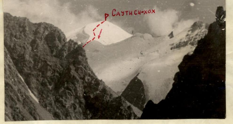
From bivouac (IV), the ascent to peak Soutisi-khokh follows an icy ridge (section RI) with a slope of 30-40°. We must walk on crampons. To the northwest, the ridge drops away onto the Midagravin glacier with huge cornices and seracs. To the northeast, there is a steep icy slope onto the Soutisi glacier. The ridge is broken by several crevasses of moderate width in its middle part, hindering progress. In two places, we encounter small ice ledges with a slope of 40° and very smooth ice surfaces. These are traversed with belay (one through an ice axe in a crevasse, the second through a piton). The snowy-icy ridge with cornices runs from north to south and leads to the summit ridge of Soutisi. This ridge is firn. A cairn is located below the summit to the south on destroyed rocky outcrops. To approach it, we must cross a crevasse 0.5 m wide.
The descent from the summit follows the northwest ridge (section RK), which drops away to the north with cornices and seracs. Initially, the ridge is firn for 200 m and gentle, with a slope of up to 35°. In several places, narrow ice crevasses bar our path. Then, the slope becomes steeper, up to 55° (section R13). Here, the slope is icy, about 200 m long. We traverse this section with piton belay and step-cutting (6 ice pitons were hammered in). Then, the ridge becomes firn and gentler, with a slope of up to 30°. We descend along it for another 150 m and then, crossing a wide crevasse (1 m wide), we emerge onto the Tep pass. The traverse of peak Soutisi (from night's halt (IV) to the Tep pass) takes 7 hours.
The Tep pass is located on the ridge between peaks Soutisi and Midagravin and leads from the Gruso valley (South Ossetia) to the Midagravin plateau. The descent from the Tep pass onto the Midagravin glacier first follows very steep, heavily destroyed schistose rocks (section R14) straight down from the cairn on the pass for 70 m, and then on crampons along steep, icy firn and ice with the aid of two ice pitons for belay, we descend down to the left to the marginal crevasse. After crossing this crevasse, we emerge onto a flat part of a small glacier that originates from the Tep pass and the seracs on the north slope of peak Soutisi. To descend from here to the Midagravin plateau, we must traverse a heavily crevassed icefall with a slope of up to 45°, and then turn left and, overcoming several wide crevasses (up to 1.5 m wide) on the way, we descend onto the glacier. We must initially walk in teams on the Midagravin glacier. When we level with peak Midagravin, we can unrope and continue down the glacier to the "Ram's Foreheads". After passing the "Foreheads" and crossing the glacier tongue to the right bank of the Gizeldon River, we continue along the trail to the foot of the "Ram's Foreheads". Here, in the valley, we set up a night camp.
Day 6
From the night's halt, we walk 7 km on foot to Jimara and then travel by car to Ordzhonikidze.
Considering that the ascent to peak Jimarai-khokh is rated as category 4A, and the descent from peak Soutisi - as category ..., as well as the complexity of the descent from Jimarai onto the ridge and the traverse of the ridge between Jimarai and Soutisi, the group requests that the traverse route of peaks Jimarai-khokh, "4398", and Soutisi-khokh be classified as a category 5A route.
Due to poor visibility on days 4 and 5 of the traverse, we were unable to take any decent photographs. Therefore, few photographs of the traverse are attached.
DESCRIPTION COMPILED BY: Tsybkin September 25, 1958

www.alpfederation.ruwww.alpfederation.ru ↗
Traverse Route of Peaks Jimarai - "4398" - Soutisi
ASCENT TO JIMARAI-KHOKH VIA THE WESTERN ROCKY RIDGE Jimarai-khokh 4776 m


VIEW OF JIMARAI RIDGE (SECTION B) FROM BIVOUAC (III)

SOUTISI-KHOKH FROM DANCHETA RIDGE
Comments
Sign in to leave a comment