
- Climbing type: rock climbing.
- Climbing area: Caucasus, Midagrabindon gorge.
- Peak, route: p. D. Gogaev (3836 m) East ridge.
- Estimated category of difficulty: 3A rock, semi-independent.
- Route characteristics:
height difference — 1200 m, route length — 1500 m, section lengths:
- 2nd category of difficulty — 350 m
- 3rd category of difficulty — 110 m
- 4th category of difficulty — 95 m, average steepness of the route — 45°, steepness of key sections — 65°
- Pitons driven: 5 rock pitons.
- Number of travel hours/days — 10/1
- Number of overnight stays: two under the route.
- Leader: Levkovsky Yu.V. — Candidate for Master of Sports.
- Participants:
- Badtiev A.K. — 3rd sports rank
- Gorbunov A.I. — 2nd sports rank
- Nebasui S.V. — 3rd sports rank
- Stadeev N.G. — 1st sports rank
- Coach: Levkovsky Yu.V. — Candidate for Master of Sports.
- Organization: KAM FA RSO-A.
 Donchenty massif. Shot from the north with a telephoto lens from height 2500 m (from under Mt. Tbaukhokh). Fig. March 1994.

View from the southeast
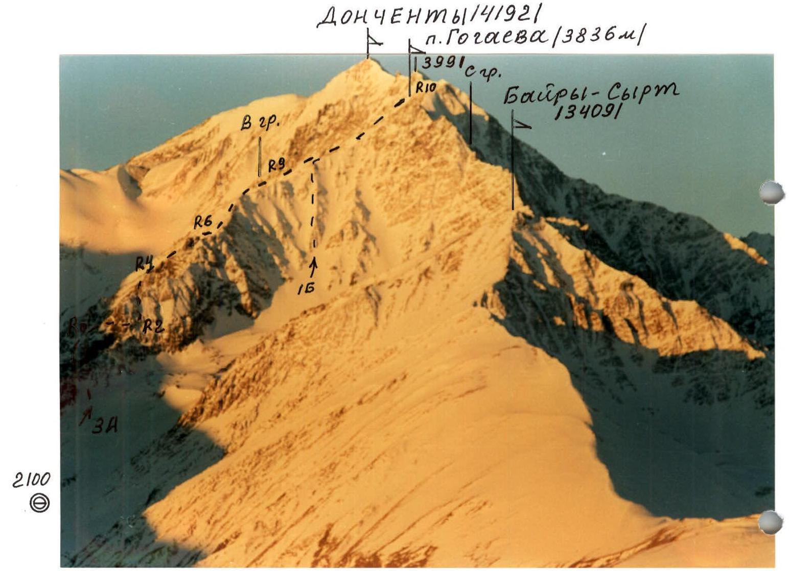
Shot from the opposite slope of the Midagrabindon gorge (2100 m). — February 2002.
Brief overview of the climbing area
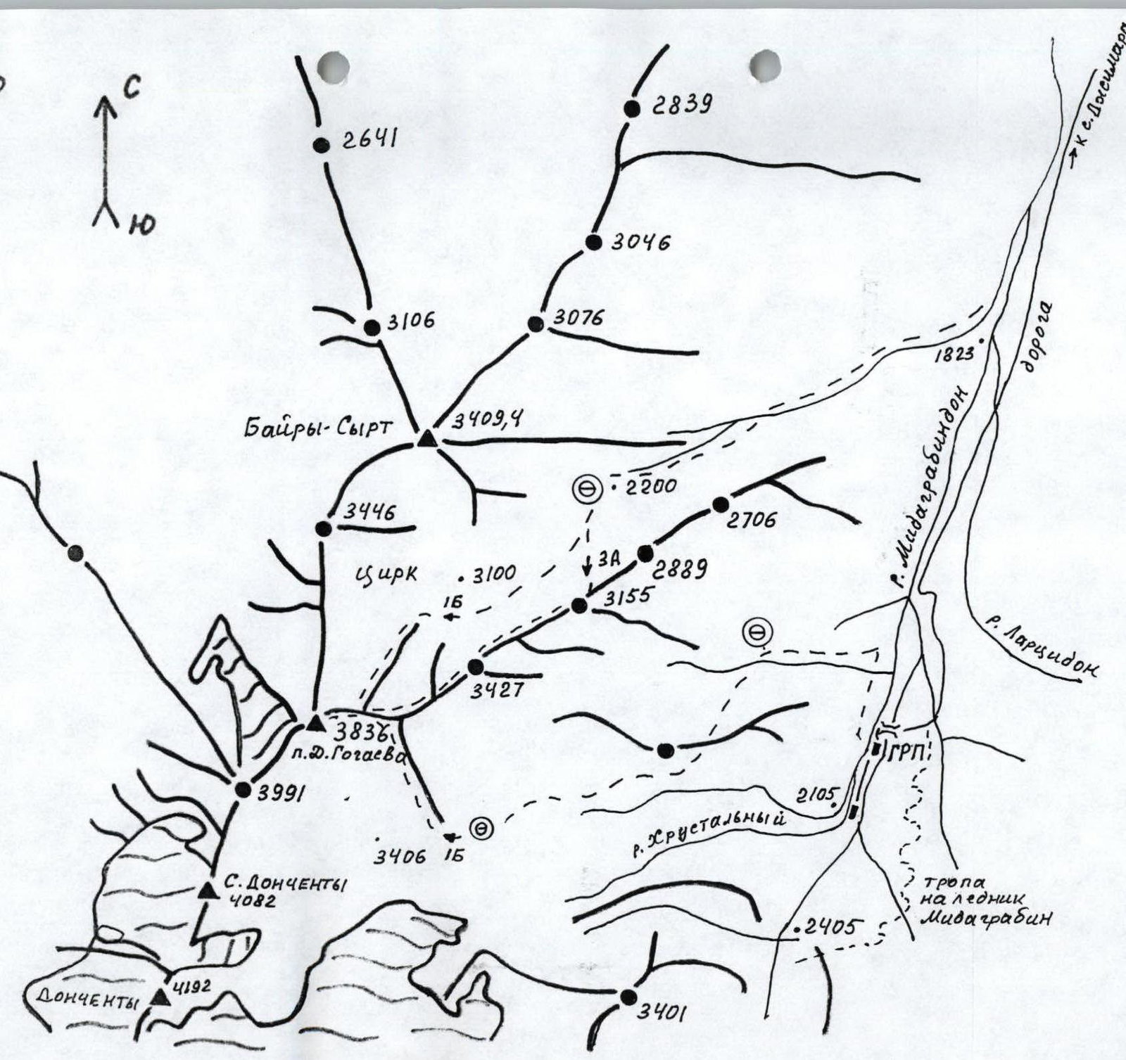
p. D. Gogaev (3836 m) is located in the northern part of the Donchenty massif between the Midagrabindon and Tsariutdon rivers. The peak is a nodal point, as three ridges branch out from it:
- the southern ridge leads to Mt. Donchenty,
- the northern ridge — to Mt. Bairy-Sart (3409 m),
- the third, eastern ridge descends into the Midagrabindon river gorge.
The northern and eastern ridges of the peak form a wide stony cirque, having two tiers: the lower one is covered with grass and settled scree, the upper one is filled with moraines, scree, and snow. The lower part of the cirque is located at an altitude of 2100–2250 m, the upper one — 3000–3100 m.
The southern and eastern ridges also form a wide stony cirque located at an altitude of 3100 m, from which the Khrustalny stream flows.
The peak clearly towers above the ridges and is a good panoramic point. Clearly visible are:
- Shau-khokh and Zeigalan,
- Syrkhu-Barzond,
- to the north — the Rocky Range.
The entire massif is composed of destroyed schists.
Route description
From the bivouac in the lower part of the cirque, move left-up in the direction of a narrow gully, leading to the beginning of the Eastern ridge of p. D. Gogaev. Further along the Eastern ridge, exit into a small hollow 250–300 m. Left-up along a 45-degree stony slope, ascend to a saddle on the Eastern ridge. From the bivouac, 2 hours.
Move along the simple rocks of the Eastern ridge towards the wall — the ridge's ascent. Traverse right-up 50 m along rocks of 3rd category of difficulty, insurance through ledges. Up the wall — the key section of the route — 50 m, then another 50 m along a snowy-stony slope, exit onto the ridge. Turning right, along simple rocks of the ridge, approach the next ascent, which is overcome on its left side. Further movement is along simple rocks of the ridge to the third ascent, climbing its wall 45 m.
Along a narrow saddle 30 m, approach a large gendarme, which is bypassed on the right. Further ascent to the peak passes along a long ridge with small rocky ascents.
Descent to the north into the cirque along 1B category of difficulty.
View from the north
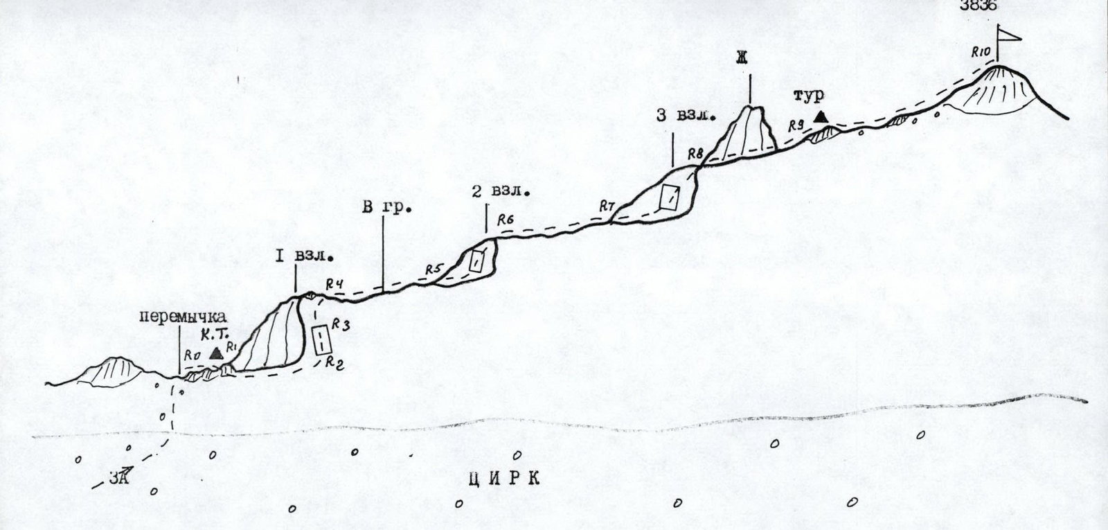
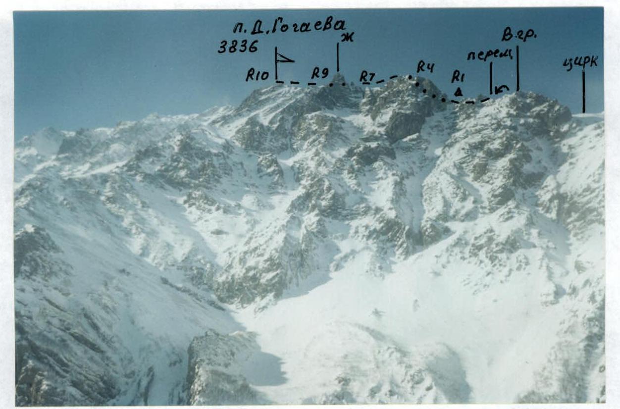
UIAA scheme for the route: p. D. Gogaev (3836 m), 3A, E ridge.
R0–R1–2:45°: 120 m — ridge rocks, control cairn. R1–R2–3:50°: 50 m — rocky slope. R2–R3–4+:60°: 50 m — wall. R3–R4–2:40°: 50 m — slope. R4–R5–1+:35°: 100 m — rocky ridge. R5–R6–3:50°: 60 m — wall. R6–R7–1+:30°: 220 m — rocky ridge. R7–R8–4:55°: 45 m — wall. R8–R9–1:20°: 30 m — narrow ridge. R9–R10–1–2:35°: 750 m — ridge.
View from the east

p. D. Gogaev, E ridge, section R5–R6. Shot from section R4.

p. D. Gogaev, E ridge, section R6–R10. Shot from section R5. Bude Boemokha
View from the east
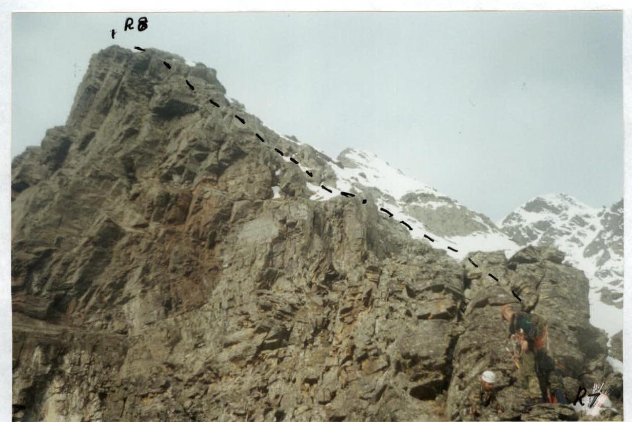
p. D. Gogaev, E ridge, section R7–R8. Shot from section R6.
Comments
Sign in to leave a comment