
Report
on the first ascent to the peak of Alexey Botyan via the Northern ridge, category 3A, by the team from the Cascade mountaineering club, from July 26 to 29, 2022.
I. Ascent Details
| № | 1. General Information | |
|---|---|---|
| 1.1 | Full name, sports rank of the team leader | Afanasyev I.O.–S. – Master of Sports |
| 1.2 | Full names, sports ranks of the participants | Zemlyakov D.S. – 3rd sports rank, Kravchenko P.P. – 3rd sports rank, Maslennikov M.P. – 3rd sports rank, Sosov A.N. – 3rd sports rank, Khabarov A.S. – 3rd sports rank |
| 1.3 | Full name of the coach | Krutikov D.A. |
| 1.4 | Organization | Mountaineering Club "Cascade" |
| 2. Characteristics of the Ascent Object | ||
| 2.1 | Region | North Ossetia, Soudorsky (Saudorsky) ridge |
| 2.2 | Valley | Khuppara |
| 2.3 | Section number according to the 2013 Classification Table | 2.2.7 |
| 2.4 | Name and height of the peak | Alexey Botyan, 4019 m |
| 2.5 | Geographic coordinates of the peak (latitude/longitude), GPS coordinates | 42°07.9′ N, 43°45.6′ E |
| 3. Route Characteristics | ||
| 3.1 | Route name | Northern ridge |
| 3.2 | Proposed category of difficulty | 3A |
| 3.3 | Degree of route exploration | First ascent |
| 3.4 | Nature of the route terrain | Combined |
| 3.5 | Elevation gain of the route (data from altimeter or GPS) | 300 m |
| 3.6 | Route length (in meters) | 500 m |
| 3.7 | Technical elements of the route (total length of sections of varying difficulty with indication of terrain type: ice-snow, rock) | Category I difficulty, ice/rock/combination – 150/145/5 m. Category II difficulty, ice/rock/combination – 0/70/0 m. Category III difficulty, ice/rock/combination – 0/70/0 m. Category IV difficulty, ice/rock/combination – 0/60/0 m. Movement on closed glacier – 100 m. Dülfer descent (on descent) – 2 × 50 m. |
| 3.8 | Descent from the peak | Via the ascent route |
| 3.9 | Additional route characteristics | Presence of water (snowfields on the Western slope) |
| 4. Characteristics of the Team's Actions | ||
| 4.1 | Time of movement (team's walking hours, in hours and days) | 7 walking hours with overnight stay at Lake Khuppara |
| :----- | :------------------------------------------------------ | :---------------------------------------------------------------------------------------------------------------------------------------------------------------------------------------------------------------------------------------------------------------- |
| 4.2 | Overnight stays | none |
| 4.3 | Departure for the route | 6:00, July 28, 2022 |
| 4.4 | Reaching the peak | 13:00, July 28, 2022 |
| 4.5 | Return to base camp | 19:00, July 28, 2022 |
| 5. Person responsible for the report | ||
| 5.1 | Full name, e-mail | Afanasyev I.O.–S., igor131af@yandex.ru |
II. Ascent Description
1. Characteristics of the Ascent Object
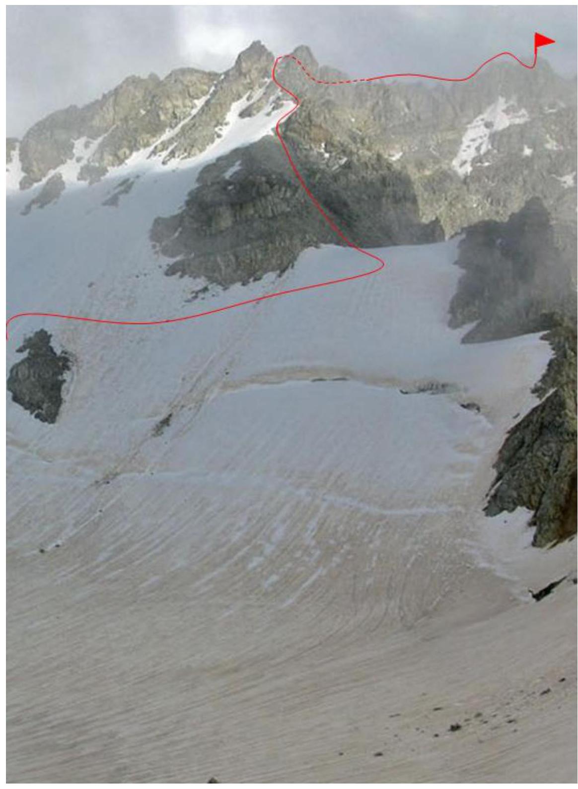
Photo 1: General photo of the peak on August 4, 2020.
Photo 2: Photo of the route profile (ridge and summit tower)

Photo 3: Photopanorama of the area
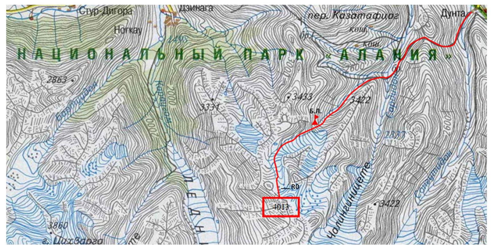
Map of the area
Overview of the Ascent Area
The peak 3939 m is located in the center of the Saudorsky ridge. The Saudor ridge (translated from the Digor dialect of the Ossetian language as "black stones") is situated in Eastern Digoria, a mountainous region of the Republic of North Ossetia-Alania. The Saudorsky ridge is approximately 10 km long. In fact, this ridge is a branch of the Bokovoy ridge located to the south. Its highest point is the Saudor peak at 4209 m, from which the Saudorsky ridge extends northwest.
The Saudorsky ridge is composed of ancient rocks: light gray granites from the Paleozoic era and dense, highly metamorphosed clay shales from the Lower Mesozoic. There are several glaciers that continue to shrink. The largest among them are:
- Chilingini
- Kadurkhoshkhin
- Khuppara
- Tsadoti
On topographic maps, the Saudorsky ridge is labeled with a spelling error as "Soudor," which is incorrect. The average height of the peaks in the ridge is around 4000 m. Surprisingly, the Saudorsky ridge is not well-explored by mountaineers, likely due to its remoteness from alpine camps in the Tsey valley and Western Digoria. In contrast, tourists have explored the ridge well, with over 20 passes traversed and described. By 2017, the Climbing Route Classifier listed only one route to the peaks of the Saudorsky ridge: the route to Saudor from the Gular glacier, category 2B.
The Saudorsky ridge is situated between the basins of the Karaugomdon River to the west and the Sardidon River to the east.
The Khuppara River is a left tributary of the Sardidon River, with a glacier of the same name in its upper reaches, which has divided into two parts by today. In the mid-20th century, geologists worked in the Khuppara valley, leaving behind traces of their activities, such as exploratory adits and remnants of trails.
From the upper part of the Khuppara valley, one can descend to the Karaugom glacier via passes to the area known as Rayskaya Polyana:
- Khuppara South, category 1B
- Vesennij, category 2B
Between these passes lies the peak 3939 m.
The approach route from the village of Dunta (1780 m), interval Dunta — Lake

Description of the Approach to the Route
To reach the starting point, take a bus from Vladikavkaz to the village of Dunta — approximately 120 km.
Due to a canyon in the lower part of the valley, it is not possible to reach the Sardidon River valley from below, so from Dunta, one must cross the Kazatyvtseg pass (also known as Dunta pass among tourists), which is 2337 m high. To access the trail to the pass, enter the village of Dunta, cross the Dargom River via a bridge, and then descend to the right to a bridge over the Songutidon River.
After crossing the bridge, follow the old trail and ascend leftward to the pass saddle in 2–3 hours. The elevation gain from Dunta village is about 600 m.
The descent from the pass goes leftward down a good trail. Within 30 minutes, you reach a cattle enclosure (kosh) where livestock are grazed during the summer.
Locals refer to the Sardidon River valley as the Skatikom valley, meaning "cattle yard" or "livestock enclosure." Due to the valley's isolation, livestock are left to graze there independently throughout the summer.
After passing the kosh, ascend to the bank of the Sardidon River and see a stream flowing into it from the right, which is the Khuppara River. Proceed about 700 m upstream from the confluence to where the Sardidon River branches out, and ford it.
Caution! In the first half of the summer, especially towards evening or after rains, the flow can be very strong!
From the pass to the ford is about 1.5 hours. This is a suitable spot for an overnight stay on the approach to the route.
Continue on the slope above the river and follow the old geological trail into the Khuppara valley. The trail generally follows the left (as you proceed) slope of the valley. In some areas, the trail is overgrown and hard to see.
Within 1.5 hours from the ford, you approach a steep conglomerate slope and ford the Khuppara River to the other bank. After crossing, follow the river towards the visible "ram's foreheads" (rock formations). After passing a major tributary flowing in from the right, proceed about half a kilometer and ford the main river again.
Among the scree, you find an old pack trail. The trail is well-preserved in some sections, with serpentine paths visible on Google Earth satellite imagery.
Follow the trail, left of a waterfall, and ascend to the "ram's foreheads," then move rightward. Continue rightward and upward along scree and moraine slopes to sandy camping spots at an altitude of 3200 m. To your left are the northern walls of the Tsakhfedor peak, and ahead lies the Khuppara peak. Coordinates of the camping spot: 42°51′10.10″ N, 43°45′52.95″ E. The journey from the Sardidon ford takes 5–6 hours on foot.
2. Route Characteristics
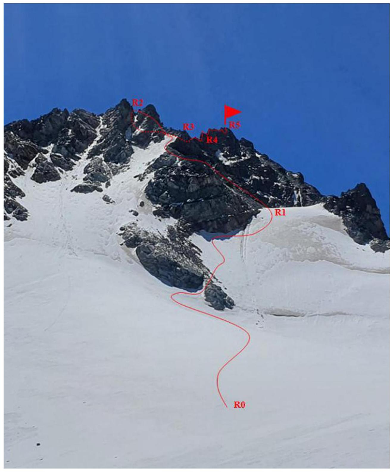
Photo 4: Technical photograph of the route
Technical characteristics of the route sections:
| Section № | Terrain Characteristics | Category of Difficulty | Length, m. | Type, Number of Pitons |
|---|---|---|---|---|
| R0–R1 | Snow-ice slope | Category I | 150 m | – |
| R1–R2 | Rocky ridge | Category I–II | 150 m | – |
| R2–R3 | Rocky ridge | Category II–III | 60 m | –2 wedges |
| R3–R4 | Rocky ridge | Category III–IV | 40 m | –3 wedges |
| R4–R5 | Rocky ledge, couloir (chimney) | Category III–IV | 50 m | –2 wedges |
3. Characteristics of the Team's Actions
Brief description of the route passage.
| Section № | Description | Photo № |
|---|---|---|
| R0–R1 | Ascend a snow-ice slope to the shoulder of the Northern ridge of the Saudorsky ridge: Category I, 150 m. | Photo 5 |
| R1–R2 | From the ridge shoulder, traverse destroyed rocks to a saddle between two "gendarme" peaks, staying on the left side of the ridge: Category I, 150 m. | Photo 6 |
| R2–R3 | From the saddle, descend 10 m and ascend a destroyed couloir to the ridge, then continue along the ridge: 60 m, Category II–III. | Photo 7 |
| R3–R4 | Proceed along the ridge to a pre-summit "gendarme"; from its saddle, rappel 7–8 m to the right to a ledge with a convenient outcrop: 40 m, Category III–IV. | Photo 8 |
| R4–R5 | Traverse the ledge for 10 m, then ascend a wide rocky chimney to the summit: 50 m, Category III–IV. The summit area is small. | Photo 9 |
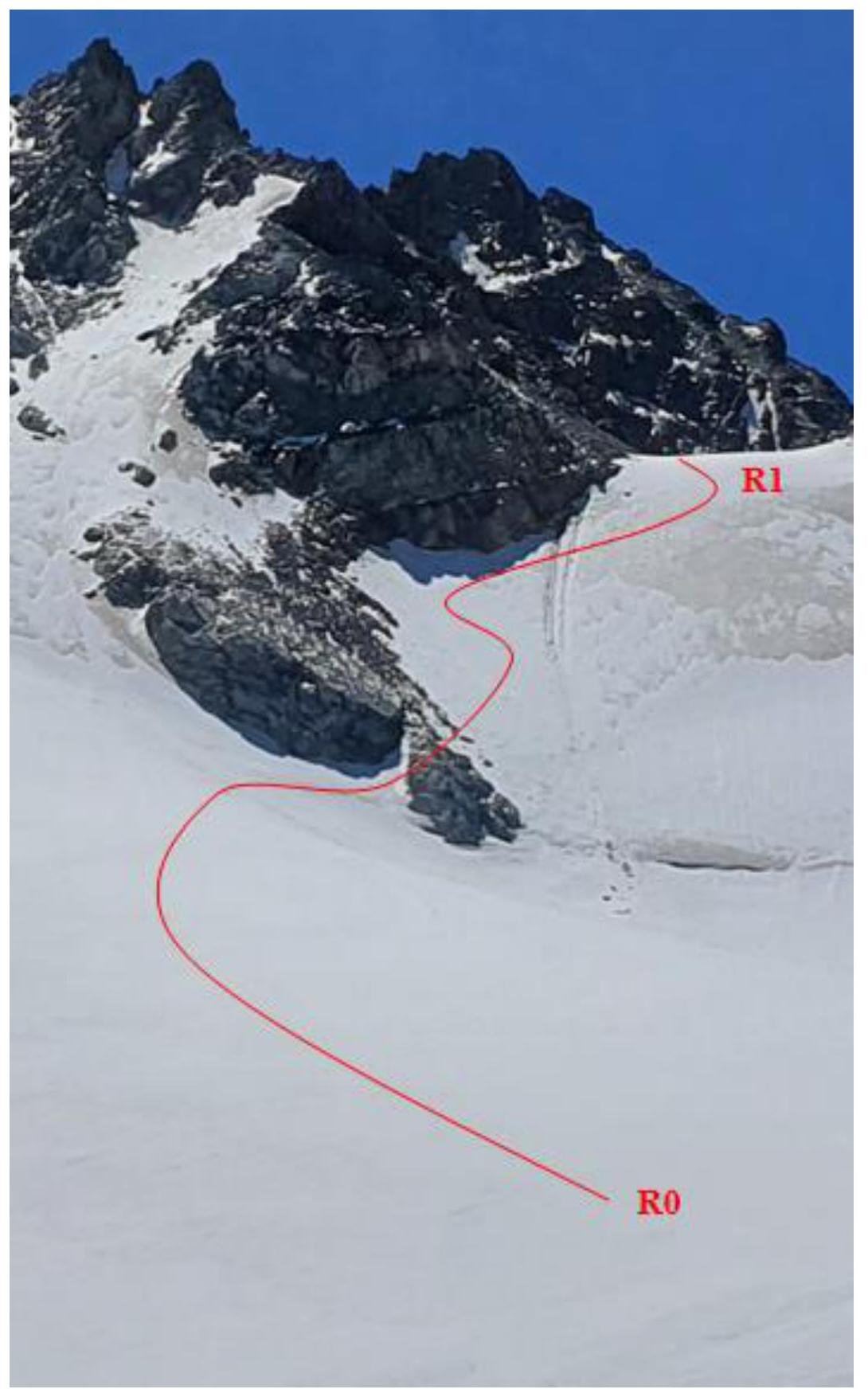
Photo 5: Snow-ice slope. R0–R1
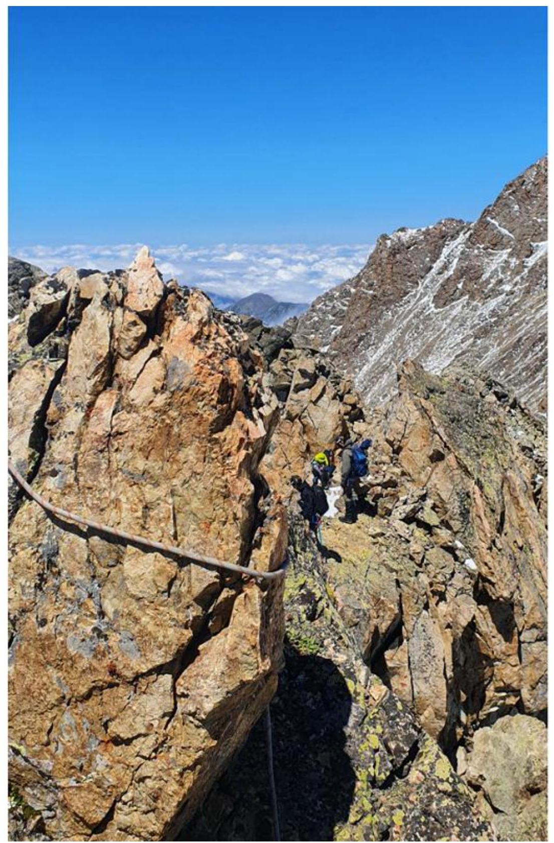
Photo 6: Ridge 150 m. R1–R2.
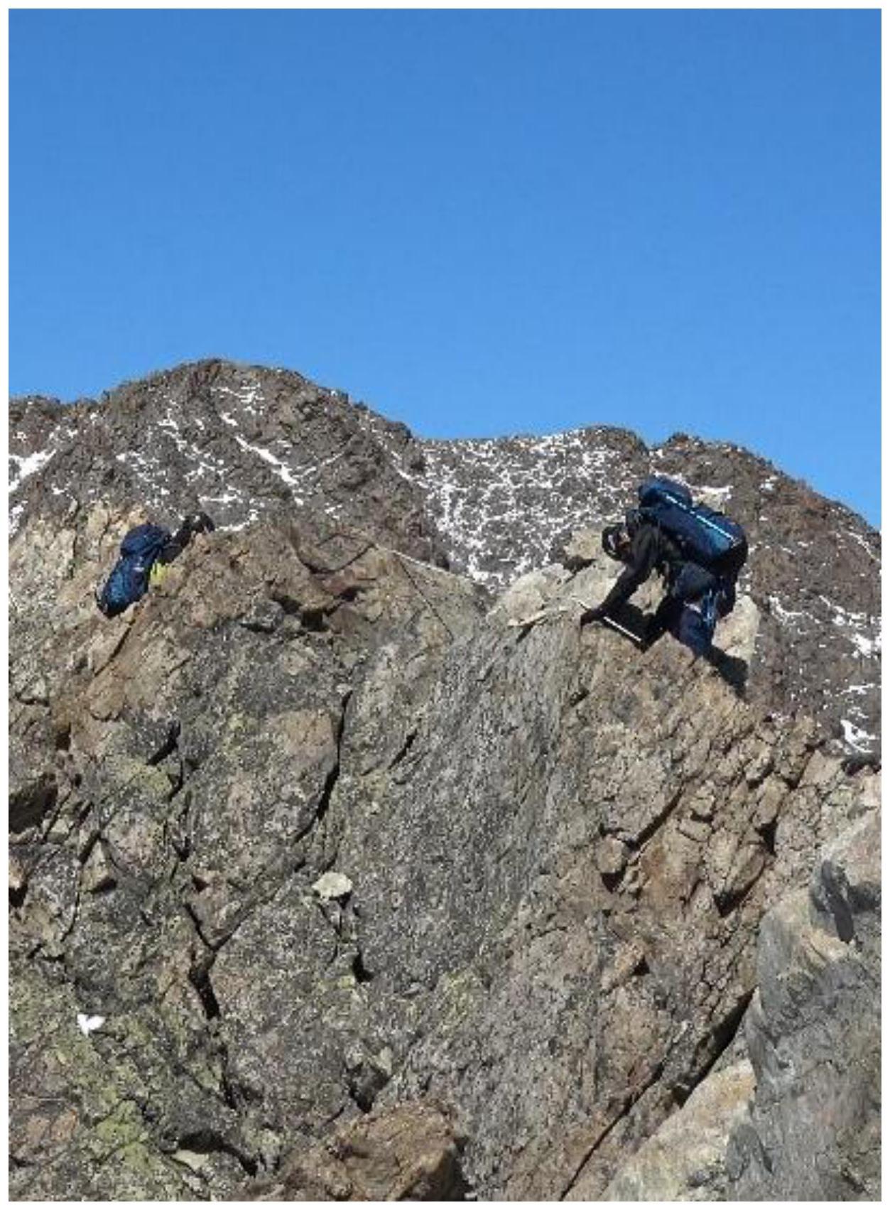
Photo 7: Ridge 60 m. Category II–III.5 R2–R3.
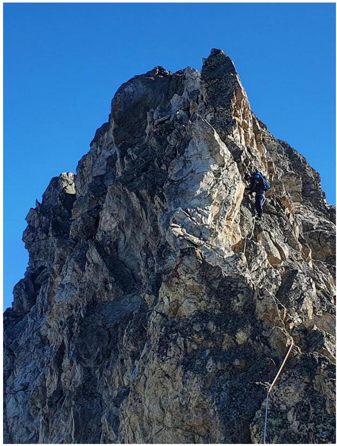
Photo 8: Ridge 40 m. Category III–IV. R3–R4.
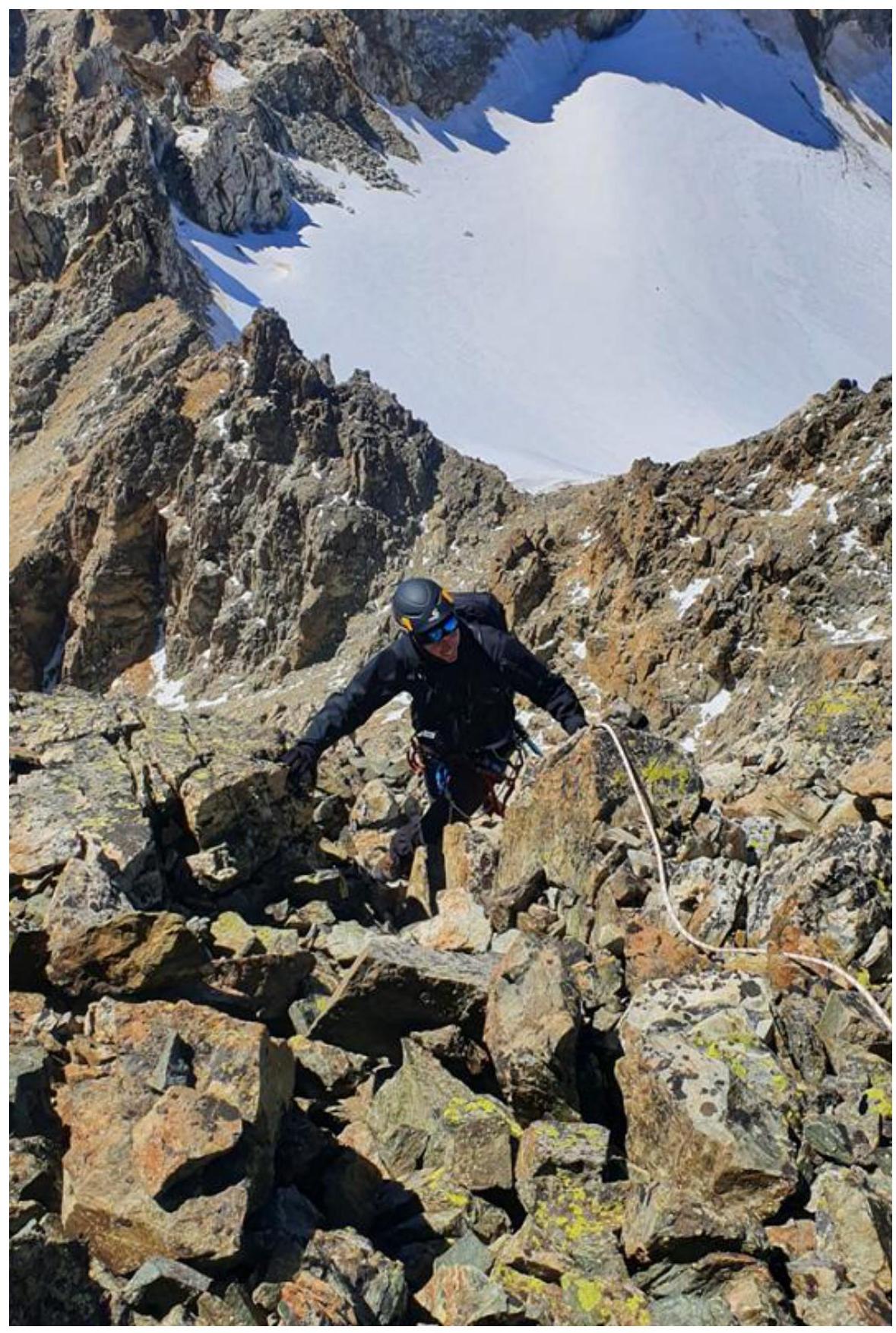
Photo 9: Ascent to the summit. R4–R5
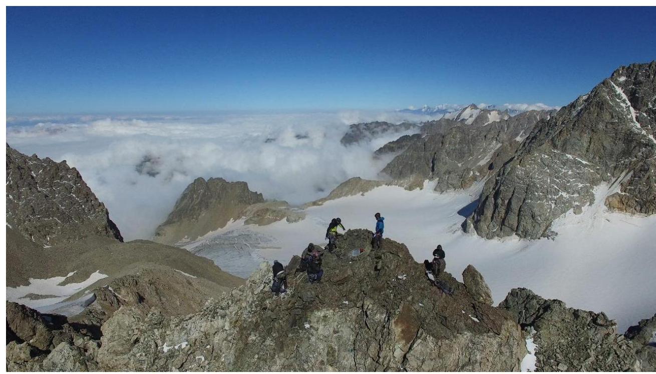
Photo 10: Summit of Alexey Botyan Peak (aerial view)

Photo 11: Summit of Alexey Botyan Peak (aerial view)
Conclusions and Recommendations for the Route
No signs of human presence were found on the summit. A memorial plaque to Alexey Botyan has been installed at the summit.
The ascent route taken by the group to the summit of Alexey Botyan is the most optimal route from the west. Descent from the summit is best done via the ascent route; two Dülfer descents were used on the descent: from the summit tower and the saddle between the two "gendarme" peaks (section R1–R2).
Caution — many loose rocks!
The route via the Northern ridge is safe with proper ascent tactics and is the easiest way to reach the summit. The route corresponds to Category 3A.
The report includes photographs from the first ascent team and images from https://caucatalog.ru↗

Government of the Russian Federation
Decree
dated November 30, 2021 № 3397-r Moscow
In accordance with the Federal Law "On Names of Geographic Objects" and based on the proposal of the Parliament of the Republic of North Ossetia-Alania, to commemorate the memory of the Soviet intelligence officer, participant in World War II, Hero of the Russian Federation Colonel Botyan A.N., assign the name "Alexey Botyan" to a nameless mountain with coordinates 42°49.9′ N, 43°45.6′ E, and an absolute height of 4019 m, located on the Soudor ridge in the Irafsky district of the Republic of North Ossetia-Alania.
 M. Mishustin