Ascent Passport
- Ascent class: technical
- Ascent area: Caucasus, Tsey district
- Peak, height, ascent route: Chančachi, 4450 m, left bastion of the NE wall (first ascent)
- Proposed difficulty category: 6B cat. diff.
- Route characteristics: height difference — 1000 m, route length — 1100 m, average steepness — 65°, length of sections with 5–6 cat. diff. — 700 m
- Number of pitons driven:
for belay for aid rock 102 21 ice 6 - bolted - - chocks 16 7
- Number of climbing hours: 38 h
- Number of bivouacs, their characteristics:
lying — 1, semi-sitting — 2
- Team composition:
Martynov Aleksandr Ilich, Candidate Master of Sports, team leader Goloshchapov Viktor Mikhailovich, Candidate Master of Sports Gorishny Valeriy Anatolyevich, Candidate Master of Sports Sychov Viktor Petrovich, Candidate Master of Sports
Team coach: Master of Sports of the USSR Neborak Valentin Stepanovich
- Date of departure and return:
- July 30, 1981 — departure from "Tsey" tourist center to the N. cirque of Tsey glacier
- July 31, 1981 — start of the ascent
- August 3, 1981 — return to the camp
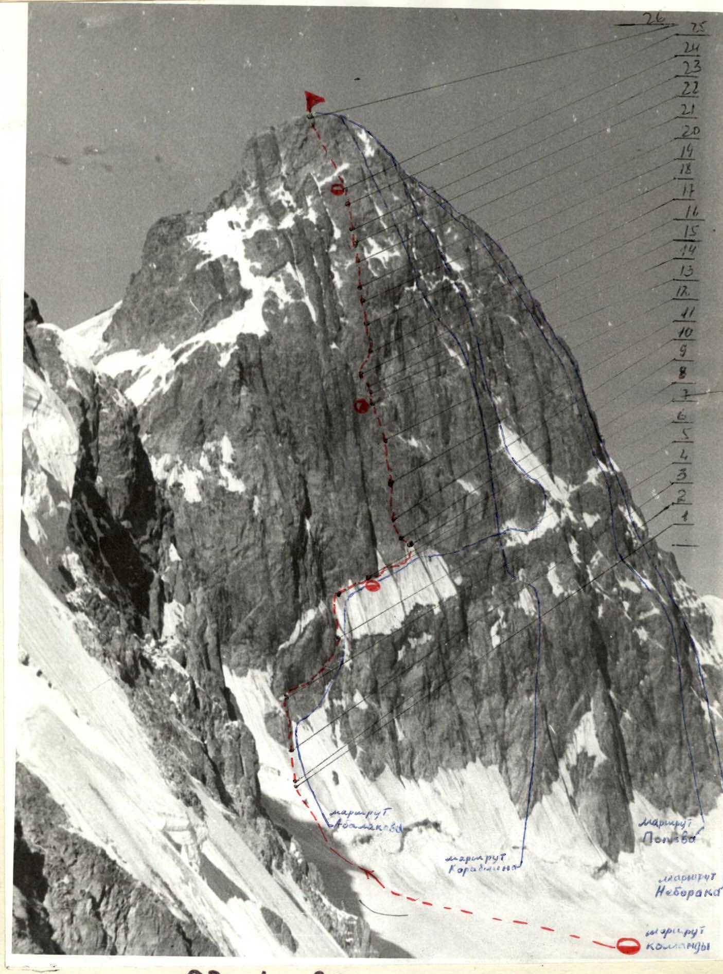
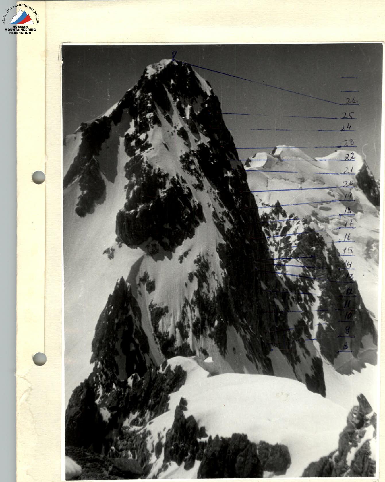
General view of the route
Brief geographical description and sporting characteristics of the ascent object
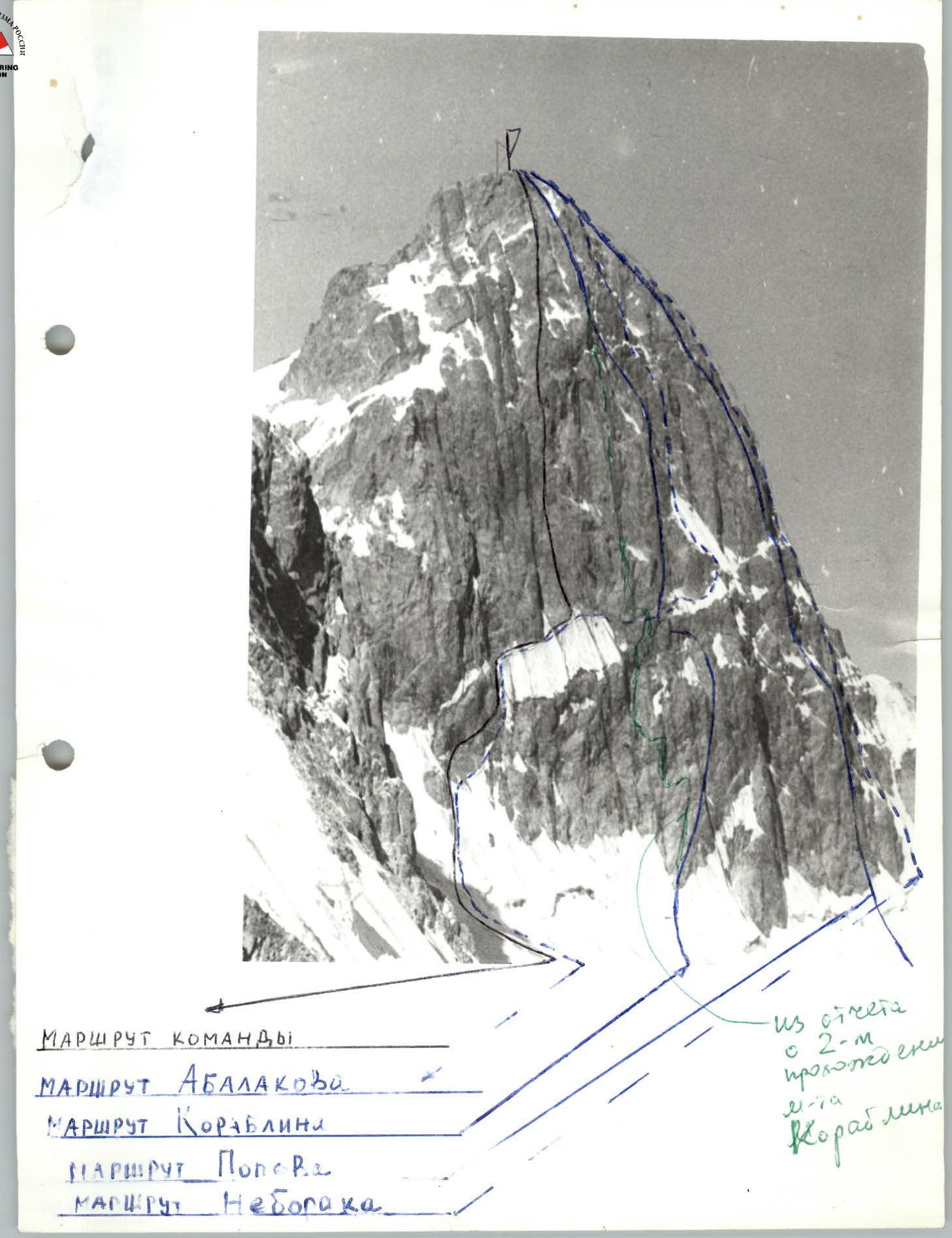
The pyramid of Chančachi (4450 m) is one of the most inaccessible peaks in the Caucasus, located near the Main Caucasian Range between the nodal peaks Bubis-khokh (4410 m) to the West and Mamisonkho (4350 m) to the East. Above the Northern branch of the Tsey glacier, Chančachi rises with sheer rocky bastions of the Northern wall. The height difference of the wall is approximately 1000 m, the average steepness is about 70°. The rocks of the upper part of the wall are heavily destroyed, which is why rockfalls are common on the N. wall, their intensity decreasing only by the end of July. Routes to Chančachi have been repeatedly entered into the USSR Alpine Championship and twice won silver medals. Currently, four registered routes of 5B cat. diff. have been laid on the N. wall of Chančachi:
- Abalakov's route on the N. wall
- "Neborak's route on the right bastion of the N. wall"
- "Popov's route on the central bastion of the N. wall"
- "Korablin's route on the left bastion of the N. wall"
All four routes are located in the central and right parts of the N. wall, while the left part, or more precisely the N-E part of the N. wall, remained unclimbed, as it was believed that the lower snow-ice section of the wall was prone to rockfall. The steepness and length of the wall attracted the team's attention, and after careful observation, a route was proposed on the N-E wall of Chančachi.
The approach to the route from the "Tsey" alpine camp is made through the Khitsan pass from the S. cirque of the Tsey glacier to the Northern one and then along its right side to the upper plateau. Then — cross the plateau and exit under the left part of the N. wall of Chančachi, where a bivouac is set up. The time to approach the "Tsey" alpine camp is 8–9 h.
TABLE of main characteristics of the ascent route to Chančachi peak
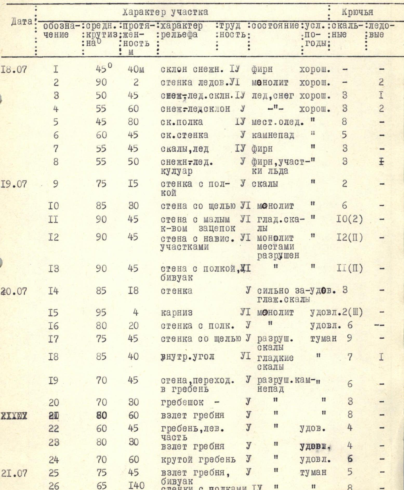
Brief explanation of the table
The route begins on the plateau, opposite a rocky outcrop located 45 m above the bergschrund (R3). From this small rocky outcrop, the ascent goes up a steep snow-ice slope (possible rockfall) under a rocky wall-island (R4). This island-rock is cut by an inclined ledge, with rocks overhanging below — this is a safe path. Move along the ledge to its end (R5). From the ledge, the team went up and slightly to the right along the wall (a poorly defined couloir) with small ledges under the wall (R6) and further movement went along the wall, along the boundary between rocks and snow-ice slope. At the angle of the wall, under overhanging rocks, a bivouac was organized. Beyond the angle — cross upwards to the right a steep snow-ice couloir (possible rockfall) and exit under the wall (R8). At the inclined yellow slabs — the first control point. From here — move left upwards to a small ledge 15–20 m. From the ledge — straight up the vertical wall. Two small cracks going upwards serve as a guide.
To the second control point — 180 m of difficult and very difficult climbing (R10–R13). Here, on a small ledge, is a sitting bivouac. At this section, ladders were used; bolted pitons could be used. The team did not use them. From the ledge with the control point — move up and left under an overhanging rock and through it along a crack — exit to a ledge (R14–R16). Here, ladders are necessary. Further — move up and to the right under an overhanging rock. The rocks here are destroyed! The overhanging rock is bypassed on the right along a sheer smooth internal corner (R18).
Then up along the destroyed rocks — exit to an inclined ledge (R19). From here, the further path is clearly visible — a steep reddish rocky ridge. To the left of it — a very dangerous couloir, along which rocks fall. The rocky ridge has very steep ascents. The ridge must be traversed along its center and left part, so that the upper sections do not knock rocks down to the lower ones. Movement along the ridge is unambiguous.
After the third ascent (R25) under an overhanging rock — a place for a bivouac, 3rd control point.
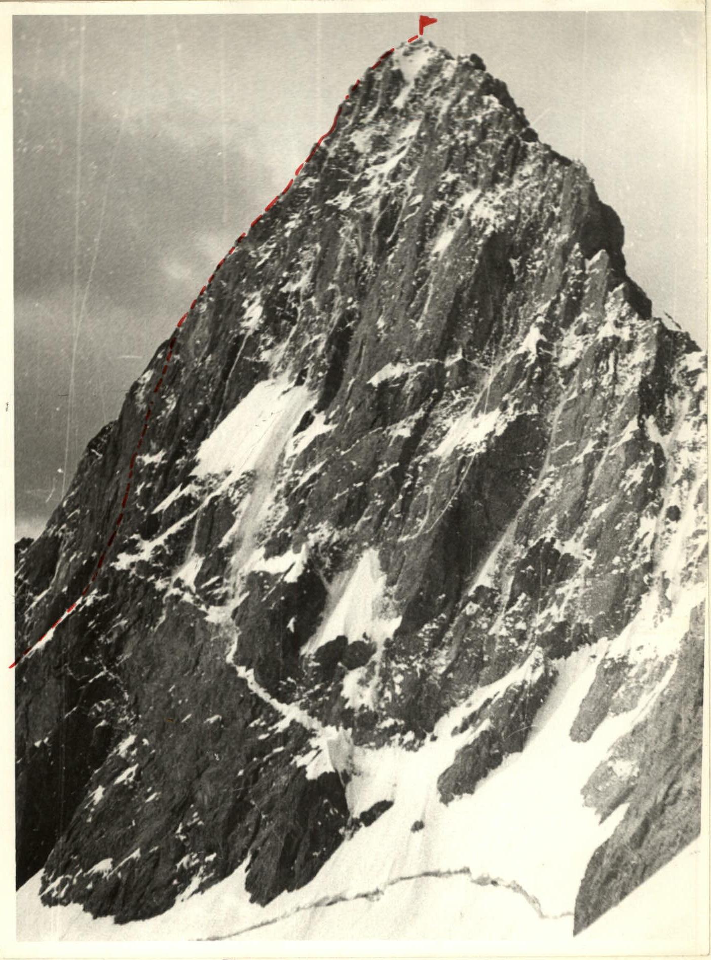
From here — move up along steep destroyed rocks, organizing reliable belay, to the summit — 140–160 m.
The descent is made along the S. ridge, along a route of 4A cat. diff.

Route profile