Kharkov
Report
on the 1967 Ukrainian SSR Alpine Championship by the Kharkov regional council team of the "Avangard" sports society in the category of technically complex ascents
Team Composition
Kharkov regional council of the "Avangard" sports society
1. Grigorenko-Prigoda Yuri Ivanovich
Master of Sports of the USSR in mountaineering, engaged in mountaineering since 1956, born in 1935, Ukrainian, non-partisan
2. Neborak Valentin Stepanovich
Master of Sports of the USSR in mountaineering, engaged in mountaineering since 1955, born in 1938 (not 1980, likely a typo), Russian, member of the CPSU
3. Bakhtigozin Vitaly Anatolyevich
Candidate Master of Sports of the USSR in mountaineering, engaged in mountaineering since 1956, born in 1937, Tatar, non-partisan
4. Zavgorodny Anatoly Grigoryevich
1st sports category in mountaineering, engaged in mountaineering since 1955, born in 1932, non-partisan
Route Description
From the "Tsey" alpine camp, we followed a trail, then a glacier to the hut under the Khitsan pass, through the pass to the northern cirque of the Tsey glacier, and then to the upper plateau of the northern cirque. A base camp was set up on the upper plateau under the route of the northern wall.
From the plateau, we ascended a snowy slope to the bergschrund under the "triangle." The bergschrund was overcome via a 5-meter snow wall with the aid of ice axe placements. After the bergschrund, a steep ice slope of accretion ice with a gradient of 80° followed immediately, then the slope eased slightly to 70°.
We traversed the ice slope to bypass the lower part of the rocky outcrop - it was steep and heavily broken. After advancing 15 meters along the rocks on ice, we reached the rocks: first, a 5-meter traverse to the right, and then straight up to the right part of the "triangle" base. Titanium screw-in ice hooks were used on the ice slope, significantly facilitating the passage of the accretion ice.
The "triangle" is a wall bounded on the left by a central ridge and on the right by a couloir that:
- is very steep;
- has 90° steps;
- and is subject to rockfall and icefall.
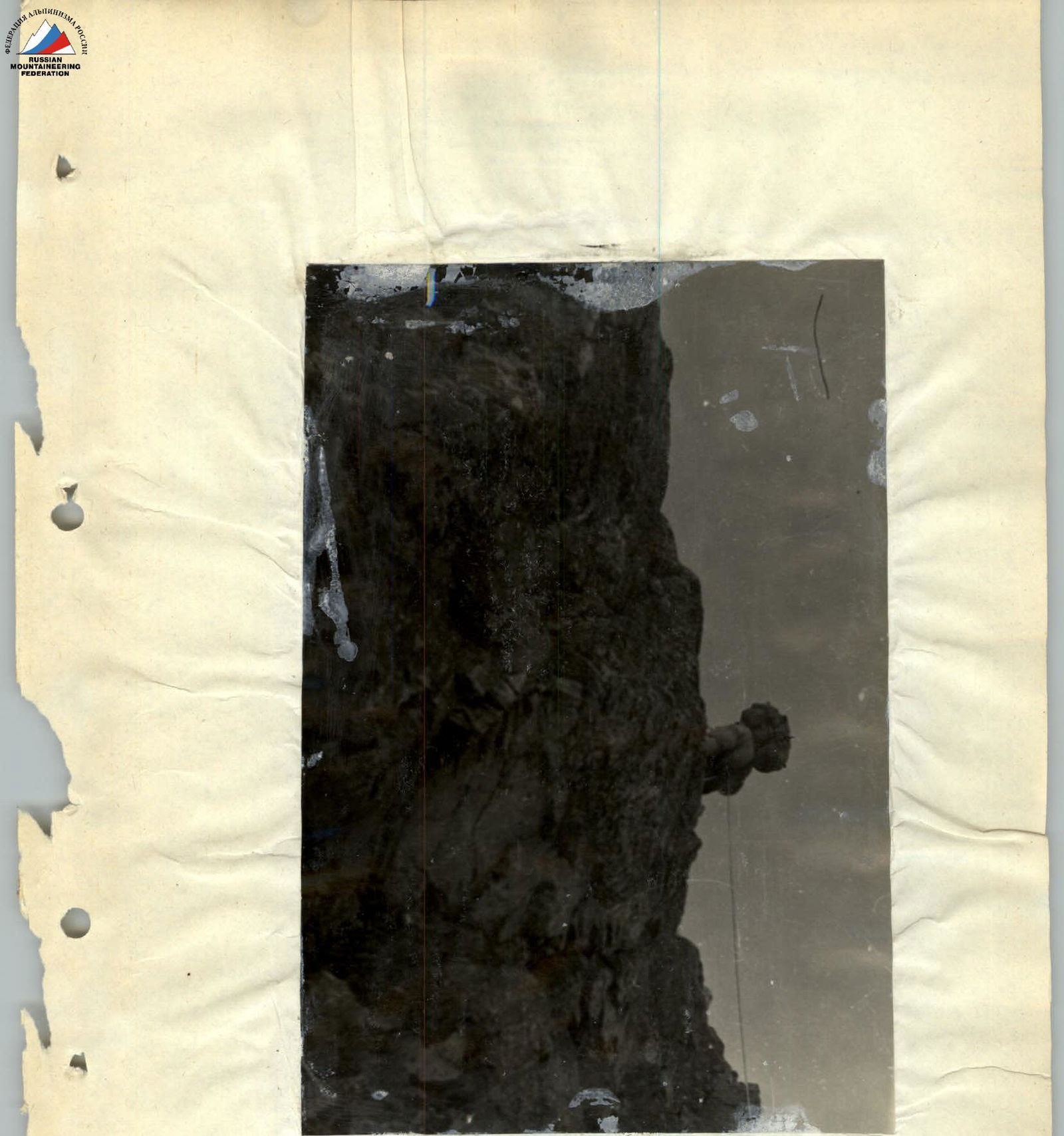
After reaching the rocks in the lower right part of the "triangle," the route follows along, near the couloir, up the rocky wall. The rocks are very steep (section 5-6) and are ascended from right to left steeply upwards, overcoming 15 meters via a not clearly defined chimney that leads under a short, steep snow ridge (section 6-7). The exit to the snow ridge is via smooth, steep slabs using artificial holds.
From the snow ridge, the ascent continues up a wall of slabs for 6 meters along a chimney with a gradient of about 90° and loose rocks (section 7-8). Section 8-9 is traversed along a wall following a "Z"-shaped, not clearly defined couloir filled with ice. Progress along this wall requires clearing the rocks of ice, hanging ladders, and potentially using pitons. Movement must be cautious, with careful selection of belay points protected from falling rocks that are thrown down the couloir.
Section R11 involves moving from right to left across slabs with a gradient of 90° or more towards the crest of the central ridge to the apex of the "triangle." The passage of the "triangle" wall, after preparation for a day and a half (6 ropes), took another two full days. There is not a single spot on the entire wall suitable for a campsite, not even for a comfortable sitting overnight bivouac. The team bivouacked in pairs, having completed about 2/3 of the wall.
From the apex of the "triangle," the path follows a snow ridge to the main ridge of Mamisontsikh (Mamison-khokh) peak. Belays were made using rocky outcrops emerging from the snow ridge and ice axes. The ridge is sharp with undulations. After reaching the ridge, a bivouac can be organized almost anywhere. The team bivouacked upon reaching the main ridge.
On the main ridge, after reaching it:
- traverse 40 meters;
- descend 40 meters to a saddle on the main ridge;
- along the ridge of the snow dome to the summit - a 20-minute walk.
Descent from the summit:
- via route 3A category of complexity to the upper plateau of the southern cirque of the Tsey glacier;
- through Pik Nikolaeva;
- descend via route 1B category of complexity to the hut under the Khitsan pass.
During the descent, the weather began to deteriorate: it became warm, the snow became slushy and did not hold well, so the descent required careful belaying, and the team only managed to descend to the hut by evening. From the hut:
- across the glacier to the "sheep's foreheads" (barranii lby);
- then along the trail - return to the camp.
Key Characteristics of the First Ascent Route
To the summit of Mamisontsikh (Mamison-khokh) via the northern wall through the "Triangle." Period: height 860 m, route gradient over 80°.
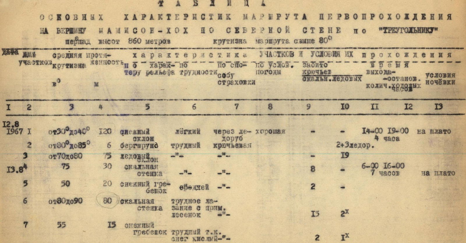
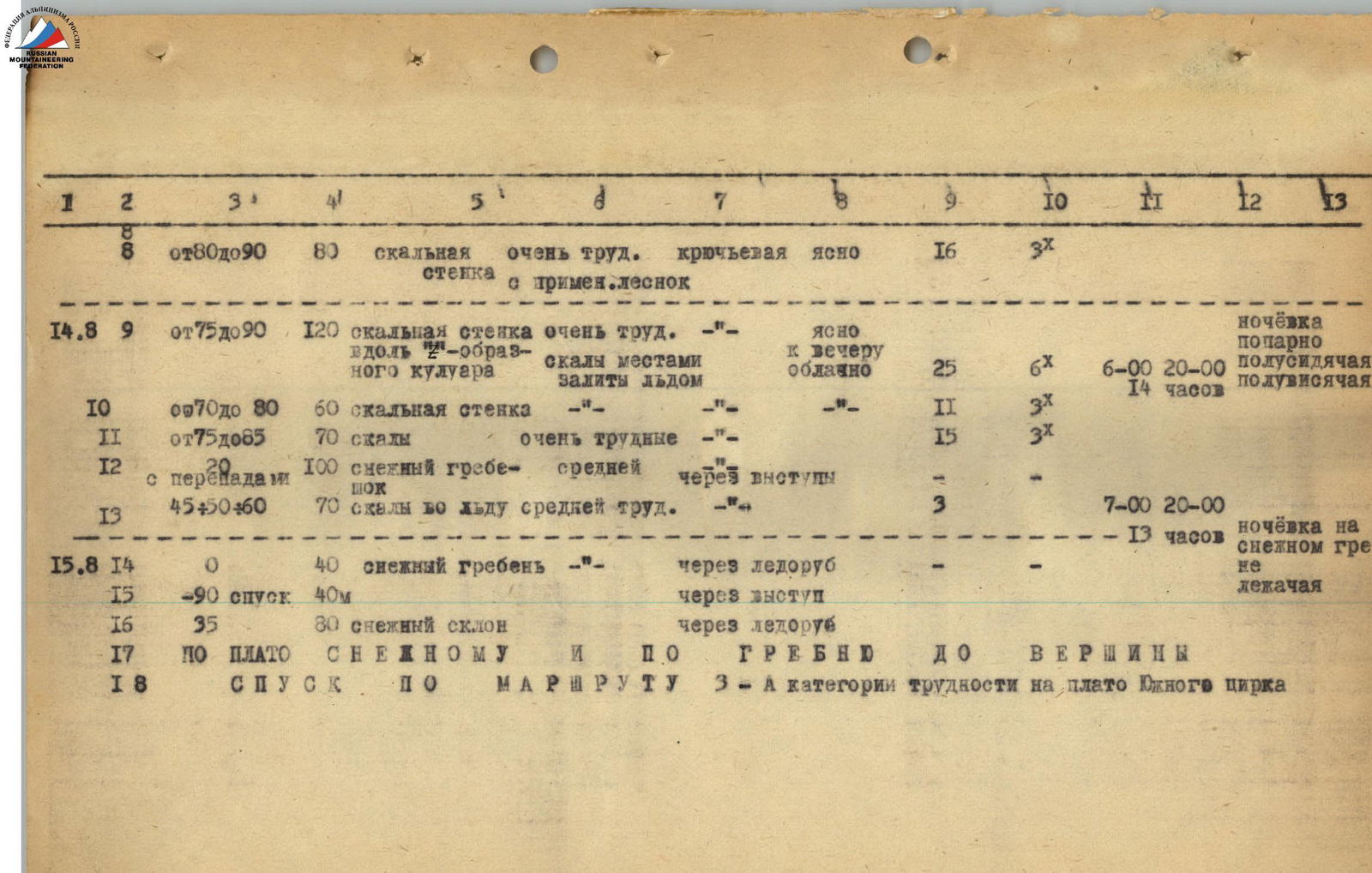
Table of Route Section Characteristics:
-
August 12, 1967
- Section R1: gradient 30°–40°, length 120 m, snow slope, easy. Passed via ice axe. Weather: good.
- Time taken: 14:00–19:00 (4 hours).
- Bivouac: on the plateau.
- Section R2: gradient 80°–85°, length 6 m, bergschrund, difficult, piton placement.
- Pitons placed: 2 + 3 (ice axes).
- Section R3: gradient 70°–80°, length 75 m, ice slope.
- Pitons placed: 19.
- Section R1: gradient 30°–40°, length 120 m, snow slope, easy. Passed via ice axe. Weather: good.
-
August 13, 1967
- Section R4: gradient 75°, length 30 m, rocky wall.
- Pitons placed: 8.
- Time taken: 6:00–16:00 (7 hours).
- Bivouac: on the plateau.
- Section R5: gradient 50°, length 20 m, snow ridge, moderately difficult.
- Pitons placed: 2.
- Section R6: gradient 80°–90°, length 80 m, rocky wall, difficult climbing with ladder use.
- Pitons placed: 15 (2 pieces).
- Section R7: gradient 55°, length 15 m, snow ridge, difficult due to wet snow.
- Pitons placed: 2 (1 piece).
- Section R4: gradient 75°, length 30 m, rocky wall.
-
August 14, 1967
- Section R8: gradient 80°–90°, length 80 m, rocky wall with ladder use, very difficult, piton placement. Weather: clear.
- Pitons placed: 16 (3 pieces).
- Bivouac: in pairs.
- Section R9: gradient 75°–90°, length 120 m, rocky wall along a Z-shaped couloir, rocks местами залиты льдом, very difficult. Weather: clear, becoming cloudy by evening.
- Pitons placed: 25 (6 pieces).
- Time taken: 6:00–20:00 (14 hours).
- Bivouac: semi-sitting, semi-suspended.
- Section R10: gradient 70°–80°, length 60 m, rocky wall.
- Pitons placed: 11 (3 pieces).
- Section R11: gradient 75°–85°, length 70 m, rocks, very difficult.
- Pitons placed: 15 (3 pieces).
- Section R12: with undulations, length 100 m, snow ridge, moderately difficult. Passed via outcrops.
- Section R13: gradient 45°+50°/60°, length 70 m, rocks with ice, moderately difficult.
- Pitons placed: 3.
- Time taken: 7:00–20:00.
- Section R8: gradient 80°–90°, length 80 m, rocky wall with ladder use, very difficult, piton placement. Weather: clear.
-
August 15, 1967
- Section R14: gradient 0°, length 40 m, snow ridge. Passed via ice axe.
- Bivouac: on the snow ridge, lying down (13 hours).
- Section R15: descent 90°, length 40 m. Passed via outcrop.
- Section R16: gradient 35°, length 80 m, snow slope. Passed via ice axe.
- Section R17: across the snow plateau and along the ridge to the summit.
- Section R18: descent via route 3A category of complexity to the plateau of the southern cirque.
- Section R14: gradient 0°, length 40 m, snow ridge. Passed via ice axe.
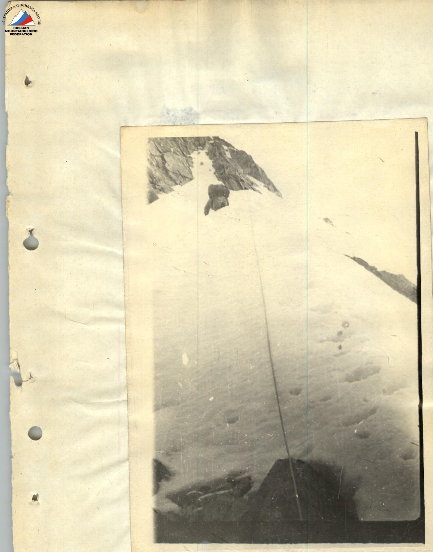
Passing the snow ridge on Section R14
Overcoming the rocky wall on Section №6