
Report on the First Ascent of Mamison-khokh Peak via the North Face to the Eastern Peak of Mamison-khokh (left edge) approximately Category 5B difficulty
Mamison-khokh Peak is located in the Main Caucasian Range between the peaks of Chancha-khokh (4461.0) and the Ronketti massif (3982). To the east of the Main Mamison-khokh Peak, a spur extends, dividing the Tsey Glacier into northern and southern cirques, which contain:
- Eastern peak of Mamison-khokh;
- Nikolaev Peak;
- Khitsan-khokh;
- Khitsan Pass.
The North Face of Mamison-khokh Peak drops into the northern cirque of the Tsey Glacier with three distinct edges (see photo).
- The right rock edge is the shortest and most gentle, leading via snowfields to the Main peak; this is a classified route of category 5A difficulty.
- The central edge is medium in length, twice as long as the right one; after exiting the edge via snow ridges and fields, it leads to the ridge between the Eastern and Main peaks; the first ascent via the central edge was made by a group from the Kiev "Spartak" under the leadership of Master of Sports of the USSR, G.V. Polevoy, simultaneously with our group (July 25 – August 1, 1964), approximately category 5B difficulty.
- The left edge is the longest, leading to the Eastern peak of Mamison-khokh; the first ascent via this edge was made by a group from the Kharkov regional council of the "Avangard" sports society.
Brief Characteristics of the Route
The first ascent of the North Face to the Eastern Mamison-khokh took 30 hours of climbing time (not counting the time for traversing from the Eastern to the Main peak and organizing three bivouacs on the route). The following were used on the route:
- rock pitons — 62 pieces;
- ice screws — 30 pieces, of which 22 were hammered into rocks;
- wooden wedges — 4 pieces;
- three-rung ladders — 5 pieces.
Additionally, 28 more pitons were hammered for safety during overnight stays. During the traverse from the Eastern peak to the Main peak, 8 more pitons were hammered. The total length of the work (on ropes) on the North Face of Mamison-khokh is 1060 m.
The average steepness of the route (wall) is 70–80°. There are many sections with a steepness of 90° and some sections with a steepness of over 90°.
The first ascent was made:
- to the peak of Mamison-khokh;
- with ascent via the North Face to the Eastern peak of Mamison-khokh;
- followed by a traverse to the Main peak;
- and descent via a category 3A route to the Southern cirque of the Tsey Glacier.
Between July 26 and August 1, 1964, the ascent was made by a team from the Kharkov regional council of the "Avangard" sports society, consisting of two groups (the exit was documented as two groups in case not all could go): B.K. Bolychevsky, V.S. Shumikhin, V.F. Rabinovich, A.F. Malich, D.D. Oleinik, and Grigorenko-Prigoda.
The participants have experience with ascents of category 5A and 5B routes:
- Shkhelda Eastern (via Garf);
- Koshtan-tau via Tikhonov Peak;
- Traverse of Uzhba from the south;
- Mizhirgi;
- Tsalgmyl;
- Lenin Peak;
- Category 5 ascents in the Tsey region of Uilpata;
- Songuti-khokh;
- Category 5A ascents;
- Category 5B ascents;
- Mekhta;
- Pkhelda 3rd Western (via "fish");
- Pkhelda Central (via the North Face);
- Shurovsky Peak;
- Eastern Dombai from the south;
- Koshtan-tau.
Based on their experience with previous ascents, the participants consider the route to be significantly more difficult than category 5A ascents. It is more challenging than category 5B routes such as Eastern Dombai and Shurovsky Peak. The difficulty and workload can be compared to routes such as:
- Pkhelda 3rd Western (via "fish");
- Pkhelda Central;
- Mekhta.
We consider the route to Mamison-khokh via the North Face to be
Route Description
Day of approach — July 26. From the Tsey alpine camp along the trail by the river Skaz-don, then by the river Tsey-don to the Tsey Glacier. Through the "ram's foreheads" over the Khitsan pass, we exit into the northern cirque of the Tsey Glacier. Staying in the middle of the glacier, we reach a snow plateau before the peaks of Mamison-khokh and Chancha-khokh. We set up a bivouac on the snow plateau before the central edge of the North Face of Mamison-khokh. From here, it's convenient to observe the route.
Day 1 — July 27. Departure from the bivouac at 6:00. The North Face of Mamison-khokh is not lit by the sun, so it's cold to work. From the bivouac, we approach the wall, then along the wall to a snowy slope falling away to the left of the edge coming from the Eastern peak. The base of the slope is broken by a large, high, and wide bergschrund. At the base of the steeply falling edge, there is a randkluft filled with ice — 90° icicles. We cross the randkluft bergschrund using ice screws and ladders and exit onto a vertical snow-ice wall, then via rocks covered in ice (piton protection), we reach a narrow horizontal ledge, traverse left (10 m), and exit to the base of a wide inclined ledge going up to the right along the wall. The ledge is 150–180 m long, with a steepness of 50° to 70°. On the ledge, there are sections with a steepness of 90° (including one section of 90° consisting of destroyed rocks — schist). The ledge is partly composed of rocks covered in ice (piton protection).
The group approached an ice bridge (15 m, 50–60°, piton protection) along the ledge. After crossing the ice bridge, we exit onto rocks covered in rime ice (25 m) and then along a ledge to the left and up to a chimney-type couloir going steeply to the left and up (30 m, 80°).
Along this couloir, we approach an ice comb (15 m, 40°) and along the comb to the base of a wall (25 m, 85°). The wall is overcome directly (piton protection).
After the wall, there's a small traverse to the left, and we approach the base of a 30 m wall under a large, hanging red slab. On the ledge under the hanging slab, it's possible to organize an overnight stay; two platforms for a semi-reclined bivouac were made. Next to the platform, there was ice, and water was dripping from the hanging slab.
Day 2 — July 28. Departure from the overnight stay at 6:30. Overcoming the wall (30 m, 80°) via an internal angle with rime ice, we approach under a hanging wall 5 m high, after which there is a 12 m wall, 85–90°, leading to slabs with snow — this was the most technically difficult section. The 5 m wall is passed using ladders along a vertical slab with a vertical crack; the first person went in gym shoes, and all backpacks were pulled up using a block system. After the wall, we exit onto slabs 40–50°, 70 m, covered in rime ice. Under the slabs, we exit onto a sharp snow ridge with abrupt drops and cornice formations on both sides (70 m). Along the snow ridge, we approach the base of the tower of Eastern Mamison-khokh, overcoming a rocky section 200 m (50°) along the ridge. We approach slabs leading to the Eastern Mamison-khokh peak. Under the slabs, we organized a bivouac. We stopped for the night at 18:00.
Day 3 — July 29
Departure from the overnight stay at 6:30. Along the slabs 310 m, the average steepness is 60°; the first person always goes along the slabs in gym shoes without a backpack; the rocks are of medium difficulty, sometimes difficult; protection via outcrops and pitons (often ice screws are hammered into rocks). Along the slabs, we exit to the pre-summit snow ridge. Overcoming a steep snow ascent (30 m, 50°), the group reached the Eastern peak of Mamison-khokh at 12:00. On the summit, a note from July 25 (year not specified) by members of the Moscow Mountain Section, B.S. Aleinik and V.A. Kizel, who made an ascent to the Eastern peak of Mamison-khokh, was found. As the group reached the summit, a storm front was approaching (ice axes were ringing, hair was standing on end). The further path was supposed to be along the ridge. Due to the approaching storm, the group descended from the summit 40 m towards the Southern cirque and quickly prepared platforms for tents. At 12:30, a thunderstorm and snowfall began. The entire day of July 29 and July 30, the weather did not improve.
July 31. The weather somewhat improved (there was no thunderstorm). Departure from the bivouac at 5:00. We descend to the saddle between the Eastern peak and the 1st gendarme. Descent from the summit 40 m and approach to the 2nd gendarme.
Second gendarme:
- Initially, it's bypassed on the right along a ledge;
- Then we move to the left side and ascend to its summit;
- Descent from the 2nd gendarme along a rocky wall 30 m with rope retrieval.
Further:
- We approach a sharp snow ridge with cornices (15 m);
- Then we approach a steep snow ridge with cornices (15 m);
- We ascend a steep snow slope (60 m, 45–50°);
- We overcome the summit slope 60 m, which leads to the summit of Mamison-khokh.
The group was on the summit at 12:00.
On the summit, a note from Polevoy G.'s group was found. At 12:00, snowfall began. Descent from the summit was made via a couloir on a category 3A route to the Southern cirque of the Tsey Glacier.
We descended through:
- Nikolaev Peak (category 1B route);
- to the hut under Khitsan Pass.
Arrived by 20:00.
On August 1, by 11:00, the groups arrived at the Tsey alpine camp.
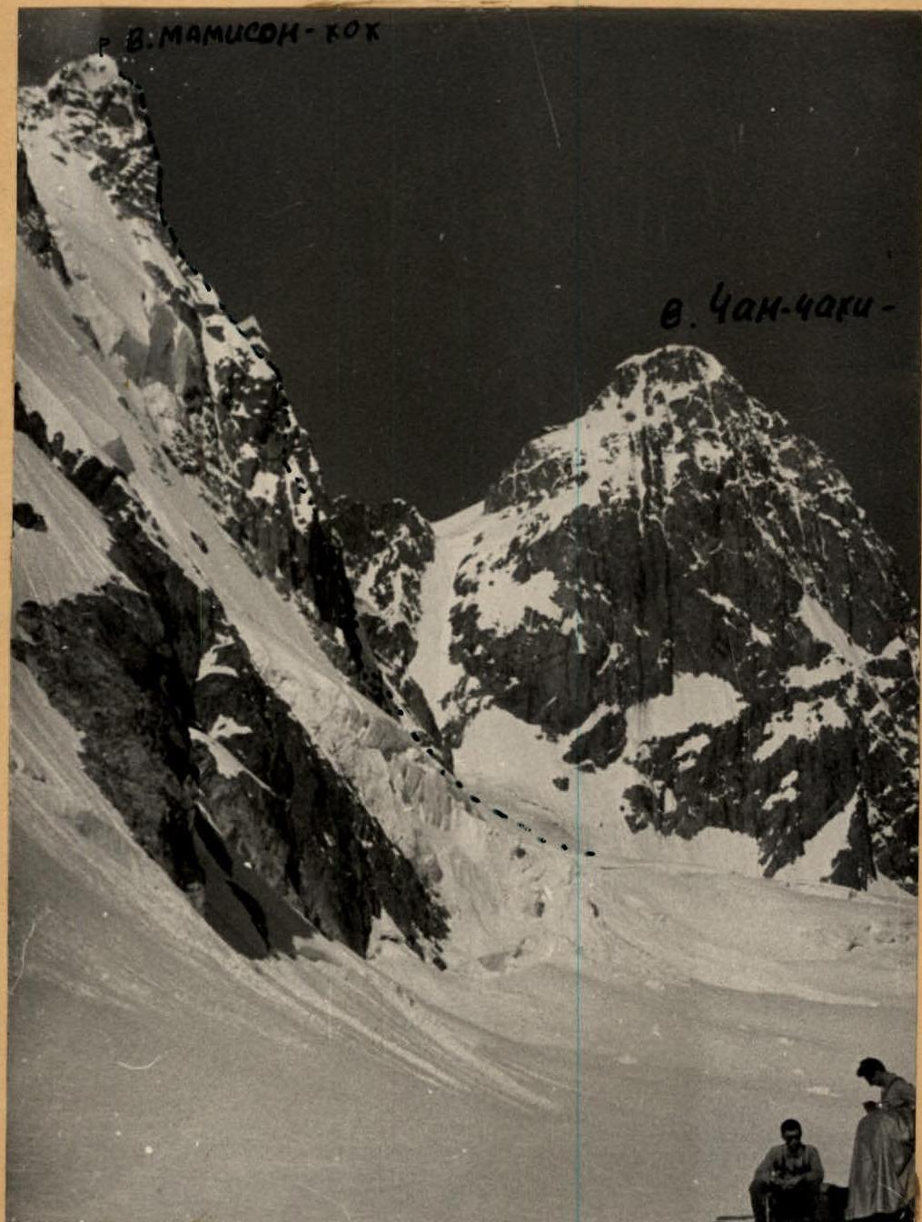
Profile of the route on the North Face of Mamison-khokh (left edge).
Average steepness 70–80°, with sections of 90° and more.
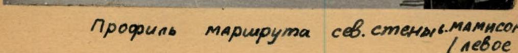
Table of Main Characteristics of the First Ascent Route to Mamison-khokh Peak via the North Face to the Eastern Peak (left edge) with a Traverse to the Main Peak
The height difference of the route is 860 m, including the most difficult sections 600 m. The steepness of the route is 70–80°.
| Date | Section No. | Average Steepness of Section | Length of Section (m) | Character of Relief | Technical Difficulties | Method of Belay | Weather Conditions | Time of Departure, Stop, Climbing Hours | Rock Pitons Hammered | Ice Screws Hammered | Bivouac Conditions |
|---|---|---|---|---|---|---|---|---|---|---|---|
| 27.07.1964 | R0 | 50° | 60 | Snow slope of avalanche outwash | Simple | via ice axe | Good | 6:00 | |||
| R1 | 95° | 4 m up; 6 m traverse | Ice-snow bergschrund | Ice ladders and icicles, ice axe wall | Piton belay | 3 | |||||
| R2 | 80° | 30 m up; 10 m traverse | Rocks covered in rime ice | Difficult climbing, chopping steps, cleaning ice from rocks | Piton belay | 3 | 2 | ||||
| R3 | 70° | 140 m steep ledge; 80 m rock wall | Steep rocks covered in rime ice; partly heavily destroyed | Complex rocks, partly medium difficulty | Piton belay, partly outcrops | 13 | 3 | ||||
| R4 | 55–60° | 15 | Sharp ice ridge of rime ice | Chopping steps | Piton belay | 2 | |||||
| R5 | 55–70° | 25 m wall; 10 m ledges | Rocks covered in rime ice | Complex rocks | Piton belay | 3 | 1 | ||||
| R6 | 80° | 30 m | Chimney filled with rock plugs and rime ice | Complex climbing | Piton belay | 3 | |||||
| R7 | 40° | 15 | Ice comb of rime ice | Chopping steps | Partly outcrops | ||||||
| R8 | 90° | 25 m | Rock wall | Passed on the left via internal angle | 5 | 5 | |||||
| 28.07.1964 | R9 | 80° | 30 | Rock wall under a hanging red slab | Difficult rocks | Piton belay | Good | 19:00 (12 hours) | 5 | Overnight stay 40 m below the hanging slab, semi-reclined | |
| R10 | 100° | 4 m hanging wall | Monolithic rocks with few holds | With the use of ladders, backpacks were pulled up using a block system | Piton belay | 6:00 | 10 | 2 | |||
| R11 | 90° (40–60°) | 12 m; 125 m | Slabs and individual rock walls | Rocks of medium difficulty, partly difficult | Piton belay, partly outcrops | 6 | 4 | ||||
| R12 | 0–60° | 70 | Sharp snow-ice ridge with drops; gendarme bypassed on the right | Piton belay, partly ice axe | 1 | 2 | Overnight stay organized on ledges of the summit tower, semi-reclined | ||||
| R13 | 70–80° | 140 | Monolithic rocks, composed of boulders, leading under the tower; traverse left and up bypasses the ice couloir and intersects in the upper part | Rocks difficult and of medium difficulty | Piton belay, partly outcrops | 19:00 (12 hours) | 4 | 3 | Bivouac located 40 m below the summit on a ledge | ||
| 29.07.1964 | R14 | 60° | 310 m | Slabs in the upper part heavily destroyed, schist | Rocks difficult, partly of medium difficulty; the first person always goes in gym shoes | Piton belay, morning, partly outcrops | Good | 6:30 | 7 | 3 | |
| R15 | 50–60° | 30 m | Snow ridge | 13:00 | Same bivouac | ||||||
| 30.07.1964 | Due to bad weather, the group stayed in shelter | Thunderstorm, blizzard | |||||||||
| 31.07.1964 | R16 | Traverse along the ridge to the Main peak with the overcoming of 3 gendarmes | Snowfall | 5:00 | 5 | 3 |
Additional Information: During the passage of the wall, the following were hammered:
- Rock pitons — 62 pieces;
- Ice screws — 30 pieces (including 22 into rocks).
During the organization of overnight stays, 28 more pitons were hammered. During the traverse to the Main peak, 8 pitons were hammered. In total, 128 pitons were hammered during the route.