Ascent Record
-
Ascent category: combined.
-
Ascent area: Caucasus; 2, 6; Sugan Range.
-
Peak, route: Uruimagovoi Peak (3912 m) via the Southeast Ridge.
-
Estimated category of difficulty: 1B category of difficulty; p/p
-
Route description:
height difference – about 500 m. route length – 1250 m. section lengths:
- 2 category of difficulty – 320 m.
- 2 category of difficulty – 550 m.
average steepness of the main part of the route – 35°.
-
Pitons used: protection through ledges.
-
Number of climbing hours/days – 5 h/1
-
Number of nights: 1 at a bivouac.
-
Leader: Levkovsky Yu. V. – CMS.
Participants:
- Leontyeva A. S. – 1st sports category
- Prevysh A. S. – 2nd sports category
-
Coach: Levkovsky Yu. V. – CMS.
-
Start of the route: August 1, 2003.
Return to bivouac: August 1, 2003.
-
Organization: AUSV "Digoriya"
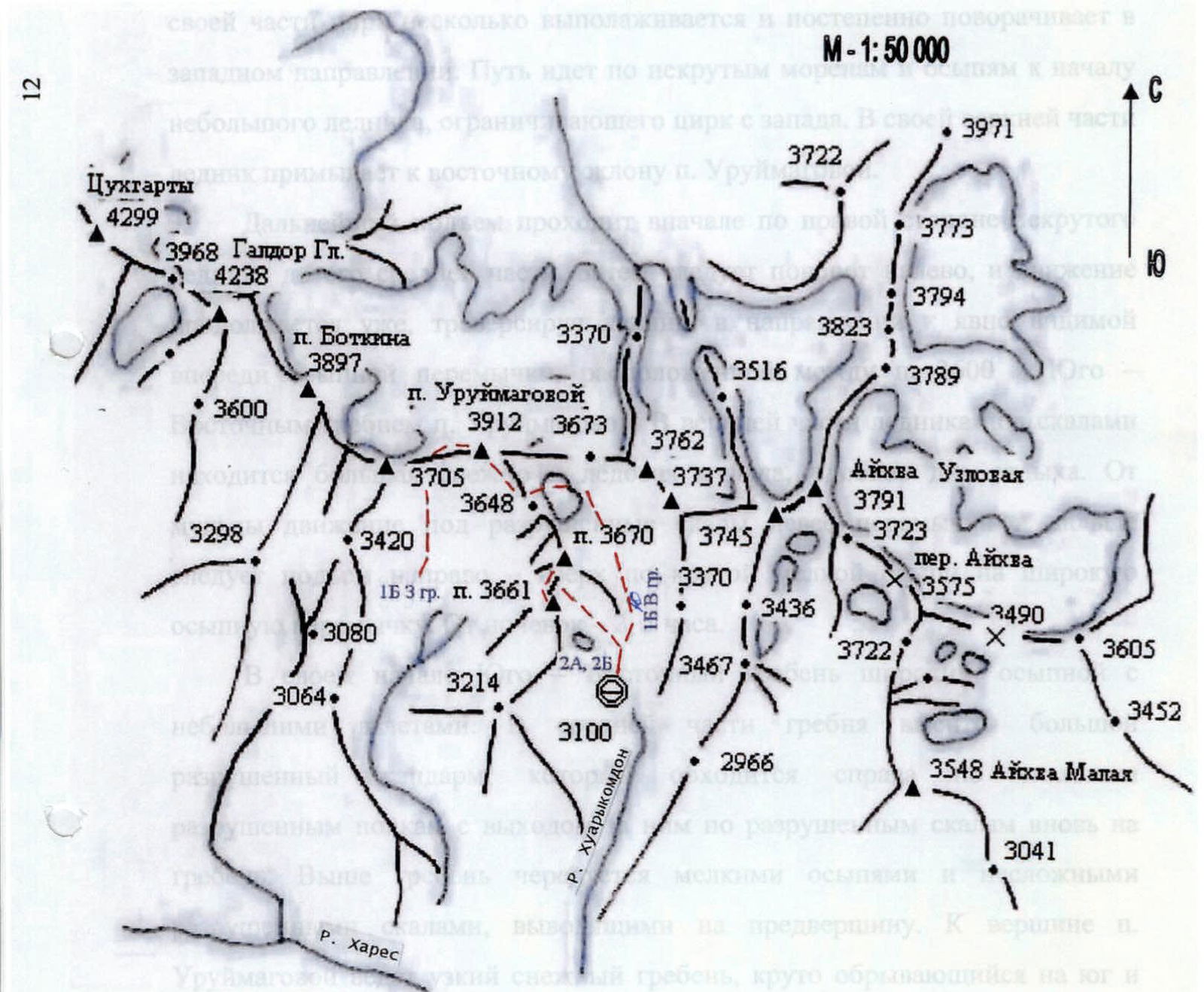
Area Diagram: Galdor Gl. — Aikhva Uzlovaya
Botkina Peak 3897
 Bud e hoca
View from the South
Uruimagovoi Peak
3912 m
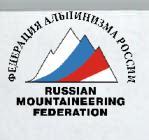
UIAA Diagram
R0–R1 – 2 category of difficulty; 550 m; 30° – glacier. R1–R2 – 1 category of difficulty – 250 m; 30° – ridge. R2–R3 – 2 category of difficulty – 120 m; 45° – broken rocks. R3–R4 – 1 category of difficulty; 220 m; 35° – rocky ridge. R4–R5 – 2 category of difficulty; 100 m; 30° – rocky-snowy-icy ridge.
Brief Overview of the Ascent Area, History of its Development
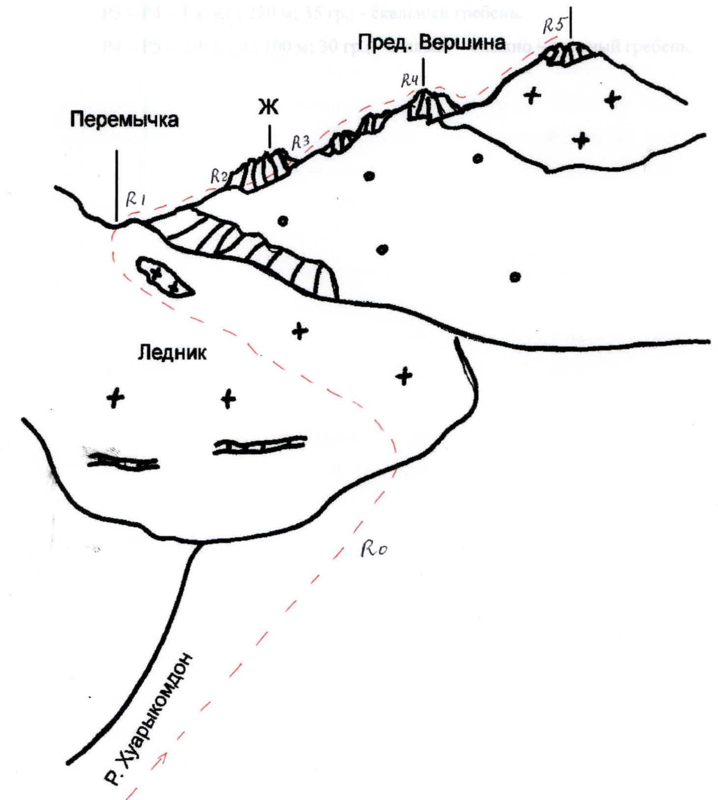
Uruimagovoi Peak (3912 m) is located in the eastern part of the Sugan Range between v. 3705 m (p. I. Akritova) to the west and Uruimagovoi Pass (3580 m – 1B) to the east. Further east, the peaks 3762.4 m and 3737.1 m rise. The massif has a Western ridge, an Eastern ridge, and a Southeast ridge, from the end of which a rocky spur with peaks 3670 m and 3661 m extends southward. In its upper part, it drops southward with steep rocky- talus slopes, lower – with rocky walls cut through from top to bottom by narrow couloirs – gullies. To the north from the summit, a snowy-icy slope descends. At the eastern base of the massif, between the Eastern and Southeast ridges lies a small gentle glacier, from which a talus cirque with moraine hills descends to the southeast and then to the south. In the northern part of the cirque, in the Sugan Range, the Uruimagovoi Pass (3580 m – 1B) and Zagadok Pass are located, separated from each other by a rocky spur extending southward.
The massif is composed of broken shales. In the spring-winter season and at the beginning of summer, a fairly large amount of snow lies in the cirque and on the ridges, some of which remains throughout the summer and autumn. Below the line of moraines and talus slopes, long, sometimes steep, grassy slopes descend southward to the Khares River. The Khuarykomdon River, originating from the cirque located to the east of the massif, connects near the farm with the Aikhvadon River, which, in turn, ending with a beautiful waterfall, flows into the Khares River. Approaches to the Uruimagovoi Peak massif are possible from the south from Galdor camps, as well as from the eastern side from the farm along the Khuarykomdon River.
Uruimagovoi Peak was named in honor of the first Ossetian writer Ezetkhan Uruimagova in 1956 by North Ossetian climbers. Previously, according to the map, it was named Galdor, which later turned out to be incorrect, as the Galdor Glavny (4238 m), Galdor Central (4120 m), and Galdor Maly (4080 m) peaks are located further west in the Sugan Range. The first route of 1B category of difficulty was laid along the long Western ridge, while the Eastern and Southeast ridges remained unattended, although, as it turned out during ascents in 2003, they are more convenient for reaching the summit.
In August 2003, in order to develop a new area and lay out climbing routes, ascents were made by two groups of AUSV "Digoriya" to Uruimagovoi Peak, following each other a day apart. As a result, the eastern part of the massif was explored, as well as nearby peaks. It was established that in the upper reaches of the Khuarykomdon River, there are a number of peaks of interest to climbers. As a result of further ascents, routes were laid on p. 3670 m 2B and p. 3661 m 2A. Reconnaissance and photography of the peaks 3762.4 m and 3737.1 m, located in the Sugan Range between the Uruimagovoi and Zagadok passes, as well as the Aikhva Zapadnaya Peak (3743 m), were carried out.
Approach to the Route Description
The bivouac is located in the lower part of the cirque below the Zagadok Pass. From AUSV "Digoriya", movement along the road to the waterfall – 1 hour. Further, the road, turning to the right – up, leads to the farm. 300 m before the farm, descend to the right along the trail to the Aikhvadon River. Having crossed it over the stones, turn left, climb straight up along the grassy gentle slope to the beginning of the grassy ridge stretching north along the river. Climb to the top of the ridge along a steep, initially wide, narrowing upward, and overgrown with thick grass slope. Further movement along the top of the ridge along a faintly marked trail to a wide flattening in the ridge.
At the top – to the left, the cirque located under the Uruimagovoi and Zagadok passes is visible. The path to it goes from the flattening initially by a gentle traverse to the left – up along the grassy gentle slope in the direction of the Khuarykomdon River, then – along it straight up along the grassy ascents leading to the lower part of the cirque. Near a large rusty stone – good sites for tents, 40 m below under the stones, a stream flows. At the place of its emergence to the surface, a cairn is installed. From AUSV "Digoriya" to the camps, the approach takes 5–6 hours.
Descent from the Summit
The descent from the summit passes along the medium and small talus of the wide Eastern ridge – slope of Uruimagovoi Peak in the direction of the Uruimagovoi Pass. Uruimagovoi Pass is a wide talus isthmus with a snowpatch descending to the north. The further descent passes along the glacier along small steep talus with an exit to a gentle glacier below its middle part and further – to the upper part of the cirque.
View from the East
 Taken from the cirque (3300 m) in July 2003.
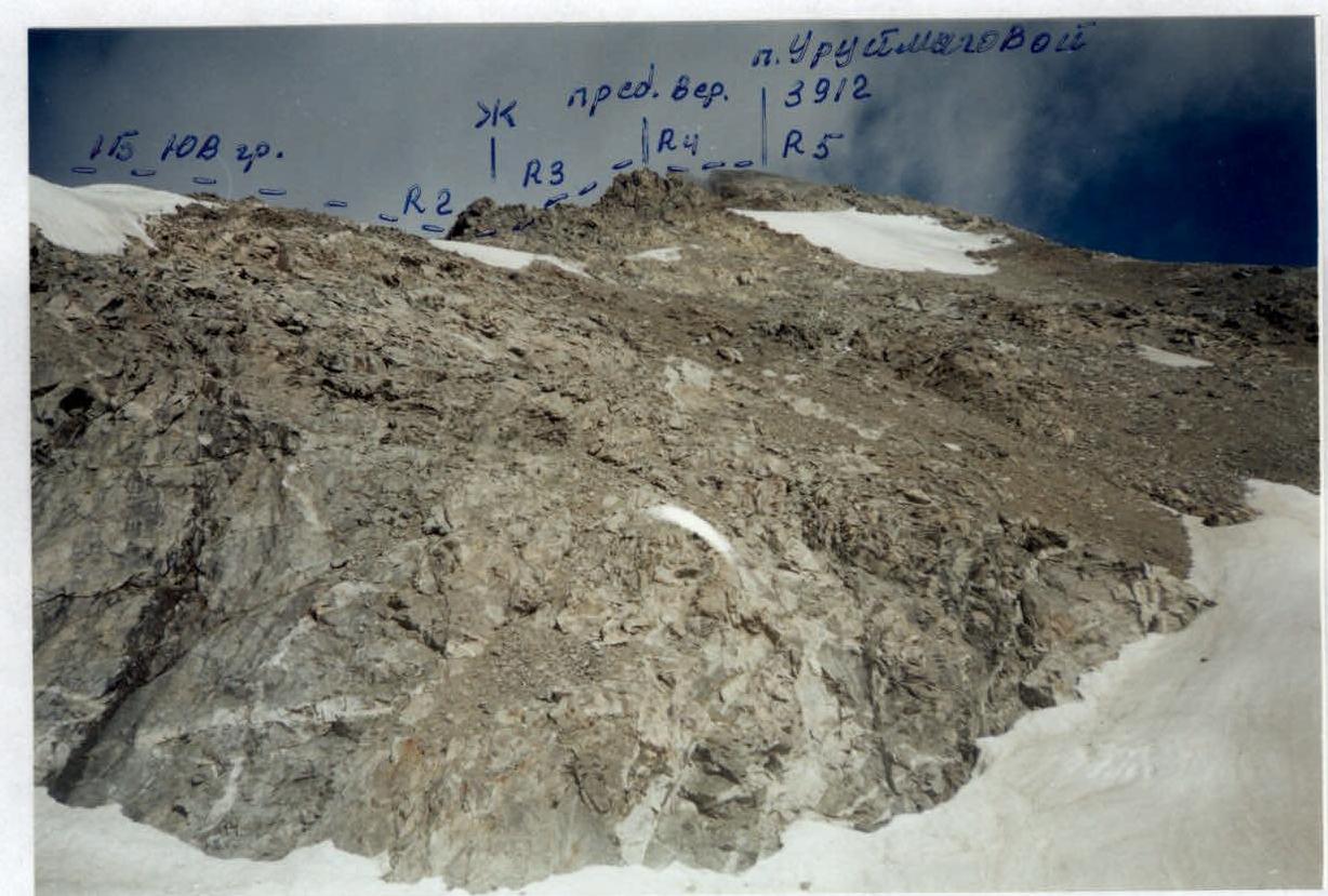 Taken from the glacier below the SE ridge of Uruimagovoi Peak (3500 m)
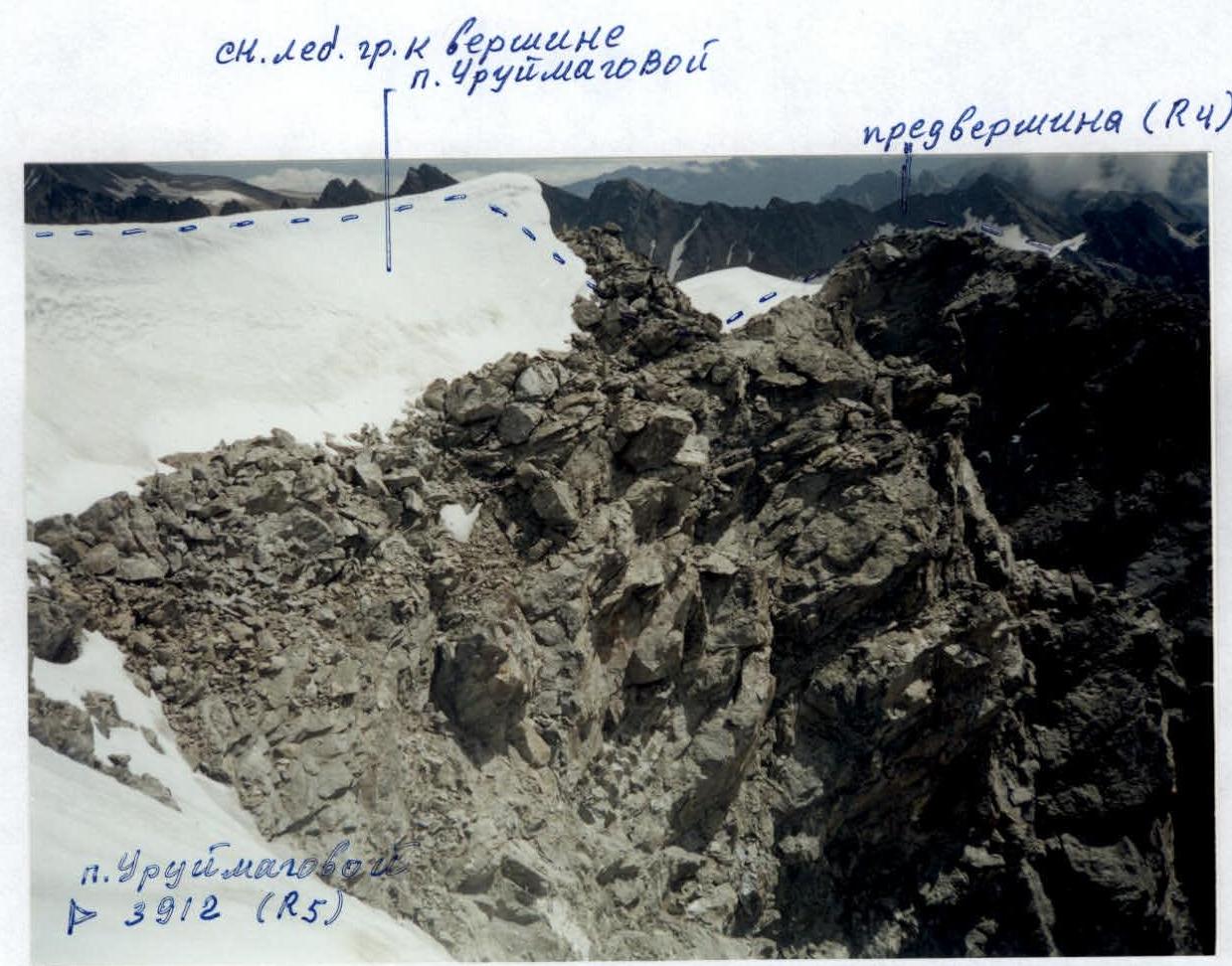 Taken from the summit of Uruimagovoi Peak.