ASCENT OF MALAYA NAKHAZHBITA

Geographical Characteristics of the Region
The Malaya Nakhazhbita peak is located in one of the most beautiful corners of the Caucasus, in the Irafsky District of the North Ossetian ASSR.
If you travel along the Urukh River valley, after gardens and stanitsas with dusty roads, after treeless, smoothed by time and greenery foothills, after dark Ossetian ancestral towers of the Akhsau, Moska, and Stur-Digora settlements, the peaks of the Suvansky Ridge suddenly emerge.
The Suvansky Ridge is located parallel to the Main Caucasian Ridge, but the former is higher and more powerful than the latter. For example, the most beautiful and highest peak of the Main Caucasian Ridge, Laboda, has a height of 4314 m, while Suvan is 4490 m, Glavnaya Nakhazhbita is 4405 m, and so on. Malaya Nakhazhbita (4225 m) is located in the middle of the Suvansky crest, to the west of Glavnaya Nakhazhbita; according to the first ascenders, it is one of the most beautiful peaks of the crest, with a logical and technically interesting route.
The group was advised and cleared for the ascent by the authorized master of sports Boris Ryazhsky, a first ascender of this peak, who provided valuable advice on:
- the route;
- equipment.
A brief description of the route according to the consultation: the route is combined, with a semi-closed broken glacier at the bottom, a snow-ice couloir leading to the crest. The lower part of the crest is heavily destroyed and rockfall-prone, followed by a wall with a single vertical crack and then a crest of monolithic blocks with small walls (5-3 m) going all the way to the summit. The descent is via route 2A cat. sl., the main difficulty of which lies in the icy ridge (8-10 ropes) from the saddle to the glacier.
The ascent conditions were excellent, the weather was stable, but autumn was already felt, with strong frosts at night and piercing winds. Naturally, this increased the volume of ice work on the routes and complicated some sections of the route.
The tactical plan was simple. Since a serious key section was anticipated on the route, it was decided to choose a bivouac as close as possible to this section and pay maximum attention to it from all points of view:
- technically,
- in terms of time,
- in the distribution of forces within the group,
- in the selection of equipment.
In case of extreme difficulties in this section, its preliminary processing was planned.
Communication with the base camp, located in the Nakhazhbita meadow, was maintained using a radio station.
Preliminary study of the route was done using descriptions and photographs taken by the first ascenders.
Conducting the Ascent
I. Description of Ascents on Malaya Nakhazhbita.
August 14, 1965
After preliminary acquaintance with the region and ascents not higher than category 3, the main sports forces of the gathering were relocated from the "Taimazi" meadow to the Nakhazhbita meadow, as it became clear that all the main routes were located there and accessing the peaks of the Suvansky Ridge from there meant saving both strength and time.
The Nakhazhbita meadow is 400-500 m above the river valley and represents an interesting step following along the entire Suvansky Ridge.
The meadow is very green, covered with a thick carpet of grasses and flowers (especially beautiful crocuses), 0.5 to 1.5 km wide, cut by numerous streams and rivers. From the grass, huge rock fragments that had rolled down from the nearby slopes stick out like houses (see photo 1). The gathering tents were set up near one of the streams. The group began to prepare. Observation of the peak is ongoing.
August 15, 1965
Wake-up at 5:00. Light breakfast and departure at 6:30. Initially across meadows, then across scree and steep stone blocks, we climb to the left moraine of the glacier descending between Malaya Nakhazhbita and Domakhi, and approach the glacier itself. The exit directly onto the glacier tongue presents a certain difficulty at this time of year, as the crevasses have widened, and snow bridges are extremely unreliable. After some searching, such a path is found, and after cutting 5-8 steps into the icy slope, we exit onto the glacier. Further, we navigate through crevasses and jump over some of them if possible, entering the main glacier cirque. There is still snow here, and the glacier is closed (see photo 2). We had to rope up and make our way along an arc to the left, as to the right, a hanging glacier descended from the peak, and judging by the ice fragments scattered across the cirque, sizable pieces occasionally break off from it. The ascent up the glacier is not steep, averaging about 10°.
At 10:00-11:00, we approached the couloir and began to move upwards. Finding the couloir is easy; one needs to orient themselves by the lowest point on the crest. The eastern wall of Donakh is very impressive, completely vertical, monolithic, smoothed, with black streaks; water and snow are absent on it. The couloir in its lower half has a steepness of 25-30°. We pass 6-8 ropes through firn; the ice axe enters well, and we move simultaneously. The last 4-5 ropes are ice with a steepness of up to 35°. The last rope is particularly difficult, with many loose rocks on the ice; we have to move very cautiously, along the edge of the ice and rocks. Insurance is initially through ice screws, then through a rock hook hammered into the rocks on the right. We exit onto a saddle and move right along the crest via very broken rocks. After 4-6 ropes, we find a hollow with a lake and make our first stop.
Time is 14:00; we examine the further path.
After an hour, we continue along the crest. The crest is sharp, broken, with whole blocks breaking off. We move with a rope length of 15 m, as with a longer rope, it usually gets stuck in the rocks. Insurance is through outcrops and hooks, alternating. The path is possible, at one's discretion, to the left and right of the crest. The crest gradually rises, with walls of 2-3 m encountered.
At 16:00, it's time to think about a bivouac. Camping close to the wall makes no sense due to the risk of rockfall. A strong wind picks up. Seeing a relatively good spot for a platform, we descend slightly from the crest and spend 1.5 hours laying out and arranging the bivouac.
- We secure the rope
- Pass it through the tent
- Set up the latter
Cooking has to be done inside the tent as the wind has significantly strengthened and it has gotten colder. The sunset over Laboda is blood-red.
August 16, 1965
Wake-up at 6:00, departure at 7:00 from the bivouac. 2-3 ropes up through несложным скалам and the crest abuts the main massif of Malaya Nakhazhbita.
From the crest upwards — left along a wide couloir, sticking to its left edge (hook insurance) — 4-5 ropes. The rocks are smoothed, with a small number of holds. Then a traverse upwards — to the right — 2 ropes along a ledge to a large stone "Obelisk", which we circumvent on the right side. The rocks have become reliable, monolithic, with firm holds, but there are few cracks. To the right in the "Obelisk" — a hook, further 2 ropes upwards to an overhang (there's a hook here). We circumvent the overhanging rocks on the right along a sloping, uncomfortable ledge; climbing requires bending, as the backpack catches on the overhanging rocks, and holds are near the feet. We emerge into a couloir with steep slabs going left — upwards, and move along the right side; the left side at the end of the couloir turns into a vertical wall. Having passed 2 ropes through the couloir with mandatory hook insurance upwards, we exit onto the right slabs and move right — upwards, orienting ourselves by the micro-relief of the rocks. After 4-5 ropes of alternating climbing on the slabs, we emerge onto a relatively good platform (with appropriate processing, a lying bivouac is possible). From here, the main key section is visible, and it looks menacing (see photo 3).
From the platform, the path goes right — upwards. The western wall, mentioned when passing through the couloir, encircles the entire peak. On the left, it overhangs; on the right, it lies down somewhat, but the main obstacle is the absence of cracks. Below, the wall seems to split off from the main massif, and a deep gap leads to a large pointed stone. Having overcome the last rock face, we wedge ourselves into the gap and begin preparing for the assault on the main complex section.
We pass all hooks and ladders to the first climber and remove his backpack. A cluster of hooks is hammered in; backpacks are removed here for a long time.
The clock shows 12:00. To the left, on a ledge, we find a cairn, and there is a note from the first ascenders, the first traversers of the Suvansky Ridge. Further to the right are poor hooks, clear evidence that this is the correct route. We find the vertical crack described by the first ascenders and begin working (see photo 3).
Characteristics of this section: smooth slabs, steepness about 70°, approximately 12-15 hooks hammered in, wall length 30 m. Overcoming the wall on ladders simplifies the work and saves a lot of strength. Processing the wall takes about 2-2.5 hours. At the top, there's a ledge; further insurance is through it. We pull up the backpacks; on a rope, we lower the ladders; the last person knocks out as many hooks as possible. The crack is wide; profile titanium hooks are very good in this case.
Further, we circumvent the peak upwards-to-the-right along monolithic, solid blocks (insurance through outcrops) for 6-8 ropes and exit onto the southern crest. When exiting onto the crest — a 5 m wall, but good, solid holds allow not to linger here long (though hook insurance is mandatory).
Further along the crest upwards — 3 ropes. The crest is very jagged, consists of giant blocks, which are overcome mainly from the right side.
Bivouac on a sloping slab, slightly below the crest; overnight stay without water. We drink only what remains in the flasks.
August 17, 1965
Wake-up at 7:00. Departure at 7:30 due to lack of water. The crest is steep, about 40°, insurance through outcrops, 7-8 ropes, the summit tower, steep rocks with good holds, and the summit.
Descent from the summit along the eastern crest, 2 sports ropes, a snowy couloir, 4-5 ropes with insurance, further down the snow to the saddle.
The time is early; we light the stove and drink our fill. The descent from the saddle is steep, an icy ridge of 8-10 ropes, steepness about 40°; the last person descends in three stages on crampons facing the slope (see photo 1).
At 11:00 — the glacier, and 2 hours later — the camp in the Nakhazhbita meadow.
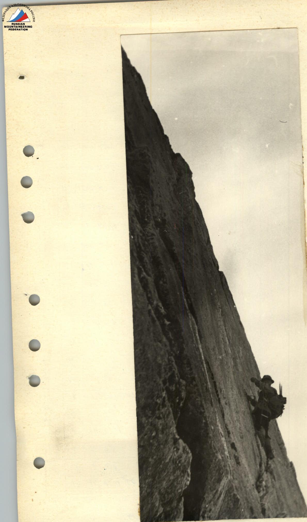 Upper part of the key section of the ascent. The only vertical crack is the path upwards.
P(w) = 60 (60–0,2w²) / ((60–0,2w²)² + w²) O(w) = –j60w / ((60–0,2w²)² + w²)
Table №4.
| w | w² | 0,2w² | (60–0,2w²) | (60–0,2w²)² | 60(60–0,2w²) | ((60–0,2w²)²+w²) | P(w) |
|---|---|---|---|---|---|---|---|
| 1 | 1 | 0,2 | 59,8 | 3576,04 | 3588 | 3577,04 | 1,00 |
| 2 | 4 | 0,8 | 59,2 | 3504,64 | 3552 | 3508,64 | 1,01 |
| 4 | 16 | 3,2 | 56,8 | 3226,24 | 3408 | 3242,24 | 1,05 |
| 6 | 36 | 7,2 | 52,8 | 2787,84 | 3168 | 2823,84 | 1,12 |
| 8 | 64 | 12,8 | 47,2 | 2227,84 | 2832 | 2291,84 | 1,23 |
| 10 | 100 | 20 | 40 | 1600 | 2400 | 1700 | 1,41 |
| 12 | 144 | 28,8 | 31,2 | 973,44 | 1872 | 1117,44 | 1,67 |
| 14 | 196 | 39,2 | 20,8 | 432,64 | 1248 | 628,64 | 1,98 |
| 16 | 256 | 51,2 | 8,8 | 77,44 | 528 | 333,44 | 1,58 |
| 18 | 324 | 64,8 | –4,8 | 23,04 | –288 | 347,04 | –0,83 |
| 20 | 400 | 80 | –20 | 400 | –1200 | 800 | –1,5 |
| 24 | 576 | 115,2 | –55,2 | 3047,04 | –3312 | 3623,04 | –0,91 |
| 30 | 900 | 180 | –120 | 14400 | –7200 | 15300 | –0,47 |
| 32 | 1024 | 204,8 | –144,8 | 20967,04 | –8688 | 21991,04 | –0,40 |
| 40 | 1600 | 320 | –260 | 67600 | –15600 | 69200 | –0,23 |
| 50 | 2500 | 500 | –440 | 193600 | –26400 | 196100 | –0,13 |
| 60 | 3600 | 720 | –660 | 435600 | –39600 | 439200 | –0,09 |
| 100 | 10000 | 2000 | –1940 | 3763600 | –116400 | 3773600 | –0,03 |

