Mukhol — Komsomol Ukrainy
In 1964, V. Shabokhin, L. Artyushenko, A. Zeidler, and V. Samoylenko traversed the ridge from Mukhol to Komsomol Ukrainy from July 17 to 21, bypassing the rocky massif of Glavnaya Izmaitsy from the east. No other ascents to the peaks of this section of the ridge were made.
- Mukhol — Komsomol Ukrainy (combined route by V. Shabokhin, 4B category of difficulty,
Fig. 2,
15).
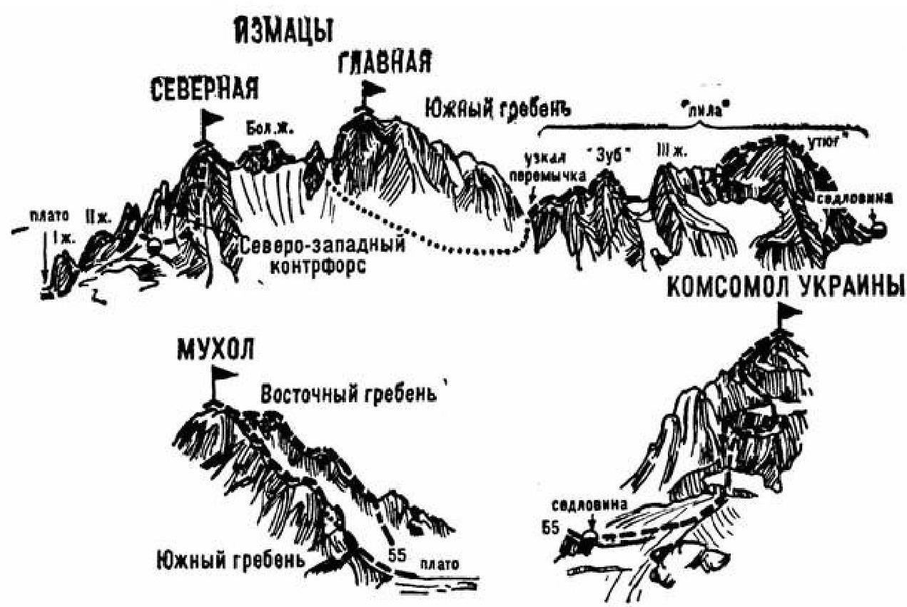
Fig. 15. From the initial bivouac on the right bank of the Rtsyvashki River (group of 4–8 people), cross the river and ascend along the bank of the stream in the lateral gorge to the tongue of the Severny Rtsyvashki Glacier, which descends from the saddle of the Sugansky Ridge between the peaks of Mukhol to the right and Severny Izmaitsy to the left. Without reaching the glacier, turn right. Then, along simple, gently sloping, gradually increasing in steepness, heavily destroyed rocks and scree of the second (counting from the base of the Eastern ridge of Mukhol peak) couloir, ascend 600–650 m to the saddle of the Eastern ridge of Mukhol.
On the saddle, turn left and:
- along simple, steep, местами strongly destroyed rocks of the Eastern ridge or along the ledges on its right side,
- pass the simple gendarme head-on,
- ascend to the summit of Mukhol.
From the initial bivouac — 4–5 hours.
From Mukhol, descend along the simple destroyed rocks of the Southern ridge (Sugansky Ridge) in the direction of the Izmaitsy massif to the first gendarme, which is bypassed with a 5-meter ascent on the right. Then:
- along the sharp 80-meter simple destroyed ridge,
- descend along inclined slabs under the second gendarme.
Bypass the gendarme on the left along heavily destroyed rocks (pitched climbing), then:
- along simple rocks of the wide Southern ridge,
- descend to the snowy saddle of the ridge connecting the peak of Mukhol with the Izmaitsy massif.
Along the snowy saddle, approach the Northern ridge of the Izmaitsy massif. Bypass the rocky tower (first gendarme) on the right and exit onto the Northern ridge. Along simple rocks of the ridge, approach the second gendarme and ascend it along rocks of above-average difficulty, 80 meters (pitched climbing). From it, make a 40-meter rappelling descent.
Then:
- 30 meters up along rocks of average difficulty on the ridge to the third gendarme (pitched climbing),
- followed by traversing its summit along ledges on the right side.
Bypass the last (fourth) gendarme on the right and traverse along scree and simple rocks on the right side of the Northern ridge to exit onto the right side of the short Northwest counterforce of the rocky tower of the Severny Izmaitsy peak.
Along steep rocks of average difficulty (pitched climbing) on the right side of the Northwest counterforce, местами to the right — along a steep, narrow, icy couloir (rockfall), ascend to a small, narrow snowy shoulder — a saddle. From it:
- along large-blocky, snowy rocks of average difficulty,
- 50-meter ascent to the summit of Severny Izmaitsy.
From the peak of Mukhol — 4–5 hours.
From the summit, descend along rocks of average difficulty to a snowy 40-meter ridge of the massif and along it (with cornices) approach the Big (Dvukhstupenchaty) gendarme. Ascend to the ridge of the gendarme along rocks of above-average difficulty (pitched climbing). Then:
- traverse along simple and average difficulty rocks of the jagged ridge,
- ascend to the gendarme and descend from it to a wide, long saddle of the massif.
Along the snowy ridge of the saddle (with cornices), approach the rocky tower of the Big gendarme before the rocky ascent to the Main peak of the Izmaitsy massif. From under the gendarme:
- descend to the left,
- along ledges, simple and average difficulty steep rocks on the left side of the massif (pitched climbing),
- bypass the Big gendarme, and then the rocky tower of the Main peak of the Izmaitsy massif.
Then, along a rocky couloir ("live" stones — pitched climbing), ascend to a narrow saddle of the massif under the first gendarme of the "saw" on the Southern ridge. Overcome this gendarme:
- head-on along rocks of above-average difficulty (pitched climbing) on the wall,
- then along a simple ridge,
- followed by rocks of average difficulty — 40-meter descent to a sharp 30-meter saddle,
- along which approach the "Zub" gendarme.
Overcome it along steep rocks of above-average difficulty head-on. From it, make a 40-meter rappelling descent to the saddle of the Southern ridge.
Along the rocky, possibly snowy, ridge with cornices, approach the third gendarme of the "saw". Bypass it and subsequent gendarmes of the Southern ridge — the "saw" — on the left with a 100–120-meter traverse along rocks of average difficulty, and then ascend to the ridge. Then:
- along steep rocks of average difficulty (pitched climbing),
- followed by gently sloping rocks of the ridge,
- ascend to the "Utyug" gendarme.
From the peak of Severny Izmaitsy — 5–6 hours.
From the "Utyug" gendarme, along a simple snowy (with cornices) rocky Southern ridge, descend to a wide snowy saddle and approach it under the northern slope of the rocky ascent to the peak of Komsomol Ukrainy. On the saddle — a bivouac. From the initial bivouac — 14–16 hours.
From the saddle, traverse to the right along a mix of ice and rocks onto a snowy ridge and ascend along it to a crevice in the rocky ascent to the summit tower. Along the crevice and rocks of average difficulty, 50–60 meters of the wall (pitched climbing), straight up. Then:
- to the right and up along ice-snow slopes,
- alternating with short walls of above-average difficulty,
- ascend to a sloping ice-snow slope.
Along the slope, exit under a not clearly defined snowy couloir, and along the couloir — ascend to the Northern ridge of the peak. On the ridge, turn right and:
- along simple snowy rocks of the Northern ridge,
- 80-meter ascent to the summit of Komsomol Ukrainy.
From the bivouac site on the saddle — 4–5 hours.
The descent to the saddle is along the ascent route. From the saddle, turn left (west) and along an ice-snow slope (possible avalanches), descend to the Gyulchi Glacier. Along it, and then along a short lateral gorge, reach the Cherek-Balkarsky River.
The duration of the route is 3–4 days.
