Moscow Regional Council of the Zeniť Voluntary Sports Society
Ascent
on Mt. Laboda via the western ridge
Digoria 1971
Brief geographical, geological, and sporting characteristics of the area
Laboda Peak
Laboda Peak (4314 m) is located on the Main Caucasus Range, between Gese-Tau to the west and Tsiteli to the southeast. Along with other peaks in the area, it encloses the Tana-don gorge. The mountain is situated within the North Ossetian ASSR, in the region known as Digoria.
There is no permanent alpine camp in Digoria; however, the area's beauty and the popularity of its routes attract mountaineers and tourists, despite the long and challenging hikes to the peaks and passes.
The mountain slopes are covered with beautiful deciduous forests, and there are many narzan springs.
The weather in Digoria, like the rest of the Eastern Caucasus, is unstable. The snow line is at an altitude of 3200–3500 m. Rivers originating from the glaciers in the area are part of the Terek River basin.
The Laboda Peak massif is primarily composed of so-called "gray granites," characteristic of this section of the Main Caucasus Range, cutting through a thickness of ancient formations represented by diverse mica schists with vein inclusions of milky white color.
The structure of the northwest wall can be schematically represented as follows:
- The main massif of the peak is composed of ancient granites, strong, with a minimal number of cracks and smoothed micro-relief, in which short belts of metamorphic rocks, represented by heavily destroyed schists, lie in sharp contact.
Information about the first ascents in Digoria dates back to 1896; however, the beginning of the area's exploration is considered to be 1933, the year of the first visit by Soviet mountaineers. Routes of categories 1 through 5 complexity have been laid out on the peaks of Digoria, and the traverse of the Sugan Ridge by a combined team from North Ossetia in 1966 took 1st place in the USSR championship.
However, the area is not considered fully explored. Many new routes can still be laid out here. This year, in addition to the existing two 5B category routes (by V. Gerasimova and V. Egorova), three more were ascended on Laboda Peak:
- via the two northern ribs and the western ridge by the LOS "Trud" team (led by Shevchenko);
- by two teams from our gathering (led by V. Penchuk and O. Fedorov).
Group training, equipment, and nutrition
During the autumn-winter period, group participants trained in their respective teams, and in the spring, they conducted joint training sessions. The training plan included:
- Winter: skiing (cross-country), swimming, gymnastics;
- Summer: cross-country running, tree climbing, and climbing towers in Tsaritsyno.
Agility, reaction speed, and coordination were improved through games like basketball and football. Before ascending Laboda Peak, participants completed several high-altitude hikes and ascended routes up to category 4B complexity as part of the MOS DSO "Zeniť" gathering groups.
The composition of the assault team was as follows:
| № | Full Name "Last Name, First Name, Patronymic" | Year of Birth | Sports Qualification | Profession | Place of Residence |
|---|---|---|---|---|---|
| 1. | Fedorov Oleg Konstantinovich | 1936 | CMS | Engineer | Kaliningrad — Moscow |
| 2. | Korsun Anatoliy Grigorievich | 1934 | MS | Engineer | Moscow |
| 3. | Strikitsa Nikolay Ivanovich | 1939 | 1st Sports Rank | Engineer | Lytkarino — Moscow |
| 4. | Makhnovich Leonid Alekseevich | 1940 | 1st Sports Rank | Engineer | Dubna — Moscow |
Team leader: Fedorov O.K.
The group's equipment and gear were selected according to the route's nature and in the necessary quantities. Mostly, non-standard titanium hooks made by the team members were used. Special mention should be made of the use of hooks and equipment of original design developed in MOS DSO "Zeniť," including:
- Rock hooks made from aluminum alloy AMG, 6–8 mm thick, used multiple times (5–6 times) instead of duralumin wedges for single or double use;
- Ice hooks made from titanium OT-4 of special design, in two types, one of which has a screw thread along the rod of rectangular section and an eye, allowing the hook to be screwed into the ice by hand force;
- Non-detachable lever clamps for ropes, a known design improved to prevent self-removal of the rope.
Additionally, for traversing complex rock sections, the following were taken:
- A drill;
- Drill hooks;
- Two-stage ladders designed and manufactured in the MOS DSO "Zeniť" section.
One pair of Asian galoshes was taken for the route in case some sections could not be traversed with crampons. One Pamiroka tent was intended for overnight stays. All participants wore helmets.
Food products were selected based on:
- Taste;
- Digestibility;
- Caloric content;
- Minimal weight;
- Compact packaging
calculated for two hot meals and dry rations during the route. Products were packed in lightweight polyethylene containers. A "Rebus" primus stove and a special kitchen set made by the ascent participants were used as a heat source for cooking.
Organization of the ascent, tactics
The ascent on Laboda Peak was planned in advance; therefore, the preparation of participants, selection of equipment and nutrition, and study of the area's map and photographs of the intended object were conducted during the preparation period before heading to the mountains.
Additional consultations on possible route features were obtained:
- At the "Torpedo" alpine camp from MS V.A. Gerasimov;
- From KSP Tsey Region representative MS B.S. Ryazhsky.
Options for ascent routes to Laboda Peak from the west were studied by the assault team members from the slopes of the Sugan Ridge (particularly from the Nakhazbita meadow, from the Doppakh Main and Nakhazbita Main peaks) using 7x binoculars and a 20x telescope.
The tactical plan provided for the simultaneous passage of the route by independent teams, with interaction on the most challenging sections. The significant steepness of the wall required clearly marking possible overnight locations, allowing for a correct time allocation during the ascent and avoiding "hanging" bivouacs. The adopted tactical plan for the ascent is presented in a copy of the route sheet (see appendix).
Due to a sharp deterioration in weather, the tactical plan was slightly altered during the assault, and the actual time allocation was as follows:
- 11.7 — approach to the Tsukhbuuni glacier;
- 12–14.7 — movement along the route to the peak;
- 15.7 — ascent to Laboda Peak and descent to the Tana-Don valley.
As evident from comparing the initial ascent plan and the actual one, the group followed the previously adopted schedule.
During the ascent, the group maintained constant radio contact with other MOS DSO "Zeniť" groups ascending peaks in the area, particularly with V.L. Penchuk's group ascending Laboda Peak via the Northern Rib. Communication was carried out using portable radios designed and manufactured in the MOS DSO "Zeniť" section and was reliable.
The route was traversed in teams:
- Fedorov — Korsun;
- Strikitsa — Makhnovich.
Ascent
Day I, July 11
Left the camp on the Taymaz meadow at 12:00. The approach route to the Tsukhbuuni glacier is known. The main obstacle — crossing the Urukh River — was successfully overcome, and by 18:00, we set up camp on the moraine at the lower part of the Tsukhbuuni glacier.
Day II, July 12
Departed at 4:30. Weather is good. Movement along the glacier in the lower part was across a patch of freezing snow, and then up a steep slope.
The ascent represents a steep, snow-covered section of the glacier broken by transverse crevasses. To climb this slope, we had to zigzag and use the most reliable snow bridges over the crevasses. The snow condition allowed for reliable insurance via an ice axe.
During the ascent, we veered right-up towards a gap in the ridge leading to the western walls of Laboda Peak. The exit to the gap was very steep, but the snow was deep enough to form reliable steps. By around 8:00, the group reached the gap.
From the gap, we followed the ridge towards Laboda Peak:
- Initially, the ridge was heavily destroyed, but the rocks were held together by ice, making the terrain somewhat challenging but less prone to rockfall.
- The first steep ascent was tackled head-on, followed by narrow snow ridges interspersed with destroyed rocks, leading up to the first gendarme.
- From under the gendarme, we traversed simple and moderately difficult rocks to the right and down onto a scree shelf (about one and a half ropes).
- We traversed the shelf to bypass the gendarme and exited onto a steep snow slope.
- We ascended the snow slope to beneath the walls of the second gendarme.
Initially, we reached a saddle between the gendarmes but realized the path from there was more complicated. We descended back down to the right (about two ropes) and began our ascent up the gendarme via its southern wall:
- Initially, the climbing was straightforward, then it became more complicated.
- Towards the end of the pitch, the climbing became challenging, with short sections having minimal handholds being traversed with effort.
- The ascent to the depression under the gendarme's peak took about two ropes.
From the gendarme, we ascended a snow-ice slope (also about two ropes) to beneath the first rocky western bastion.
The rocks were practically vertical, with smooth monoliths to the right. To the left, two unclearly defined rock ridges or very blunt outer corners were visible, separated by a shallow groove. Further left, the bastion was bounded by walls dropping into a steep, glaciated couloir with signs of rockfall.
The path up the bastion wall was practically unambiguous. At 16:00, one team set up a bivouac while the other processed the bastion wall:
- Along the snow ridge to beneath the bastion rocks.
- Traversed horizontally for half a rope.
- Up the groove directly.
Climbing was very difficult; the rocks were smoothed, and the not-so-deep handholds typically contained rimed ice.
After 18:00, the team descended, having fixed two ropes and about 30 m of rappel line in the lower section.
Day III — July 13
In the morning, the weather was good. From the east, everything was obscured by the bastion walls, while from the west, the peaks were clearly visible.
The Elbrus Region
We ascended via the fixed ropes on the bastion wall. At the end of the first pitch, there was a section of unstable rocks, so it was traversed very cautiously; the lower climber waited for their partner to pass this section. There was no natural shelter.
After the fixed ropes, we ascended and moved slightly (4 m) to the left to bypass the overhanging sections. Then:
- Very challenging climbing for about 30 m;
- Followed by a small platform where we organized the hauling of backpacks.
From the platform:
- 6 m left-upwards;
- Then along a smoothed inner corner vertically upwards.
There were virtually no holds for crampons. We had to fix a ladder and then, on friction, ascend another 15 m to a steep ridge with good handholds.
Then:
- Along the ridge to a snow slope;
- Along the snow slope to a snow-ice shoulder beneath the II bastion of the western ridge.
The walls of the II bastion were even more imposing and as steep as those of the I bastion. Additionally:
- The vertex of the bastion triangle connected to the ridge via a short but fairly deep gap;
- The right side of the bastion triangle dropped down almost vertically;
- To the left, short rocks framed a steep couloir descending from the gap.
The most logical path was to exit onto the ridge of the northwest wall. The weather began to deteriorate.
We traversed the steep snow slope and, using insurance via rock hooks on the western wall, exited onto the ridge. It was 16:00, and the weather had deteriorated significantly.
We moved up the wall along the ridge but, realizing the difficulty of the path, dug out a platform for a tent, as our reconnaissance indicated that the next suitable location for a bivouac with a tent was 120–150 m above our current position on the northwest wall ridge.
Throughout the night, graupel fell, accompanied at times by strong wind gusts.
Day IV. The morning did not bring any change in the weather. A short council was held on July 14. It was decided to continue moving upwards. During the night, graupel had fallen, and the rocks were relatively clean. From the bivouac, we moved directly up the wall along the ridge. The ridge was steep, with inclined sections alternating with overhangs, so we had to move along the wall beside it. Climbing was challenging, with the first climber going without a backpack. The weather had worsened significantly. Visibility was 40 m. Wet snow began to fall, covering the rocks and forming an icy crust.
By 16:30, we managed to traverse about 4 pitches of smoothed rocks, cut by smooth wide and narrow grooves.
On a very short ice ridge, we hacked out a platform for a sitting bivouac. We organized a bivouac using our building skills and ingenuity, resulting in:
- A suspended tent;
- Hot tea.
Although we had to sit crouched all night, we also managed to process a section of the wall upwards by one rope. Throughout the night, snow continued to fall. The tent was damp, and our down gear was soaked through.
Day V, July 15. In the morning, despite the bad weather and the route's poor condition, we continued upwards. During an evening radio check-in, we received confirmation of sustained bad weather, so there was no point in waiting for a change. Besides, the sitting bivouac was not conducive to waiting.
From the bivouac, we moved slightly right and upwards 40 m to a steep snow-ice shelf. From the shelf, we moved left-upwards along a snowy ridge beneath the sheer black rocks for about 50 m. Along the rocks to the right-upwards — exit onto the ridge of the northwest wall — one rope of a very tense section: the ice axe did not hold, there were no cracks in the rocks, and the ice chipped when hooks were driven in. Using scarce insurance points, we exited onto the ridge. Along the ridge directly upwards — rocks of medium difficulty, 40 m, led to destroyed rocks with outcrops of milky white quartz. Behind a belt of destroyed schists, there was a steep rocky ascent of the ridge, which was bypassed on the right. After 80 m — ascent via a short wall onto a snowy ridge. It was 11:00.
Along the ridge upwards towards the western peak. The ridge was not very challenging, with individual sections of medium difficulty that required alternating insurance. At 12:00, the group reached the western summit of Laboda. The fog was so thick that for 30–40 minutes, it was impossible to determine the direction of descent towards the Main Peak. However, after managing to orient ourselves, we continued towards the Main Peak of Laboda:
- Initially, a steep descent, followed by a plateau — traversed along the ridge with cornices.
- Then an ascent of about two ropes. Again, we had to wait.
- Sometimes the fog parted for 500 m, and we could determine our route.
The ascent to the Main Peak was via a snow-ice slope, and around 16:00, the group reached the peak. The descent to the Tana-tsete glacier was in the fog. After 3.5–4 hours, we set up camp on the moraine.
Day VI, July 16, 1971. The morning weather was good; the moon had shone the previous night, and Laboda Peak was clear of clouds. Descent:
- Initially along the left slopes of the spur;
- Then along the glacier in the Tana-don gorge — took about 1.5–2 hours.
During this time, the weather in the Laboda area deteriorated again. The peak was once again shrouded in white clouds. The journey from the tongue of the Tana-tsete glacier to the camp on the Taymaz meadow took 4 hours.
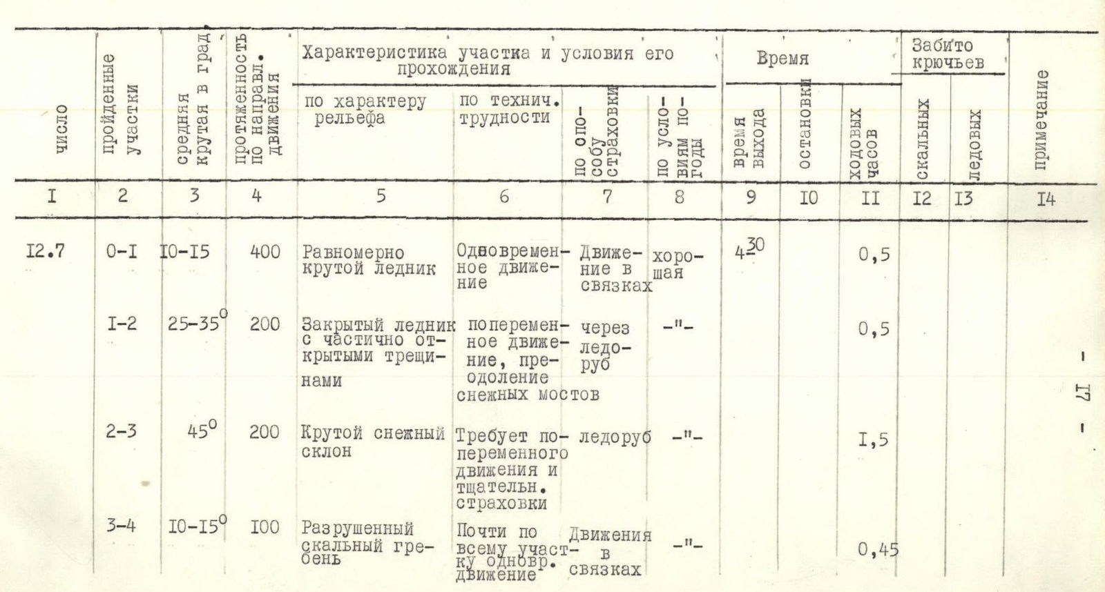
| Date | Sections traversed | Average steepness in degrees | Length in the direction of movement | Terrain characteristics | Technical difficulty | Insurance method | Weather conditions | Departure time | Stop time | Walking hours | Rock hooks driven | Ice hooks driven | Notes |
| 12.7 | 0–1 | 10–15° | 400 m | Evenly steep glacier | Simultaneous movement | Movement in pairs | Good | 4:30 | 0.5 | ||||
| 1–2 | 25–35° | 200 m | Closed glacier with partially open crevasses | Alternating movement, crossing snow bridges | Via ice axe | – | 0.5 | ||||||
| 2–3 | 45° | 200 m | Steep snow slope | Requires alternating movement and careful insurance | Via ice axe | – | 1.5 | ||||||
| 3–4 | 10–15° | 100 m | Destroyed rocky ridge | Mostly simultaneous movement | Movement in pairs | – | 0.45 | ||||||
| 4–5 | 0° | 80 m | Jagged rocky ridge with short sections of sharp snow ridges | Simultaneous and alternating movement | Protrusions, ice axe | Good | 0.45 | ||||||
| 5–6 | 0–45° | 120 m | Rocky walls with many loose rocks | Easy and medium difficulty rocks | Protrusions | Good | 1.5 | ||||||
| 6–7 | 45° | 60 m | Snow slope | Well-formed steps | Ice axe | – | 1.5 | ||||||
| 7–8 | 60–75° | 40 m | Steep monolithic wall in the upper part, loose rocks | Challenging climbing in the upper part, tense | Hooks | – | 1.5 | 3 | |||||
| 8–9 | 45° | 40 m | Rocky wall with good handholds | Rocks of medium difficulty | Protrusions | – | 0.7 | ||||||
| 9–10 | 15–18° | 60 m | Snow-ice slope | Alternating movement. Snow allows for step formation | Ice axe | Good | 0.3 | ||||||
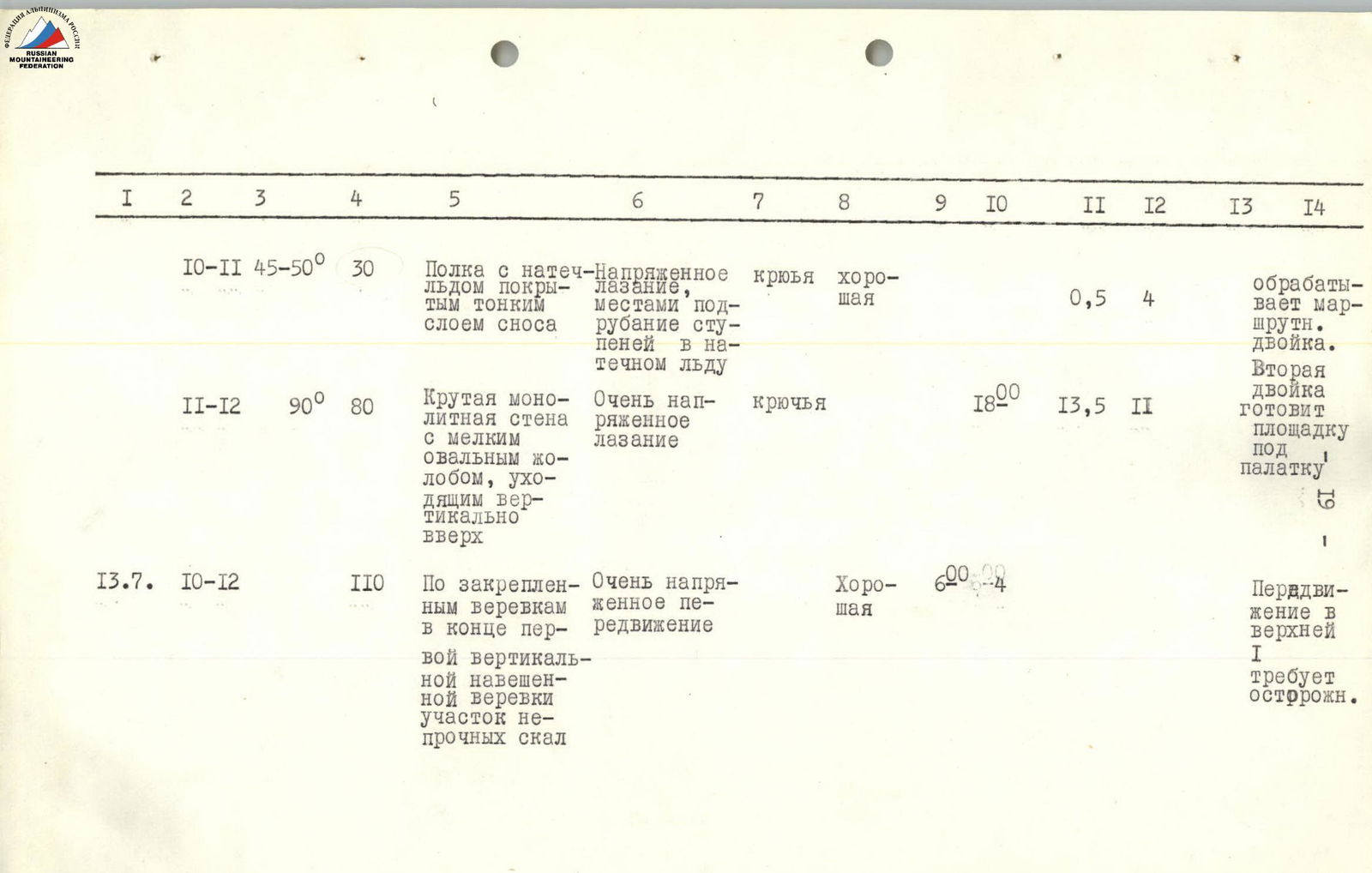
| 10–11 | 45–50° | 30 m | Shelf with rimed ice covered with a thin layer of debris | Tense climbing, partly chiseling steps in rimed ice | Hooks | Good | 0.5 | 4 | Team processes the route | ||||
| 13.7 | 11–12 | 90° | 80 m | Steep monolithic wall with a narrow oval groove going vertically upwards | Very tense climbing | Hooks | 18:00 | 13.5 | 11 | Second team prepares bivouac site | |||
| 10–12 | 110 m | Along fixed ropes, at the end of the first vertical pitch, a section of unstable rocks | Very tense movement | Good | 6:00 | Movement in the upper part of I requires caution. | |||||||
| 12–13 | 90° | 80 m | Steep wall with overhanging sections | Very tense and challenging climbing on one section when passing the overhang. Used 2-stage ladder. Hauling backpacks | Hooks | Cloudy | 4 | 12 | |||||
| 13–14 | 45–50° | 200 m | Steep snow slope on ice substrate | Challenging climbing | Hooks | Initially cloudy, then poor weather | 16:00 | 10 | Hooks driven into the wall along the movement direction. | ||||
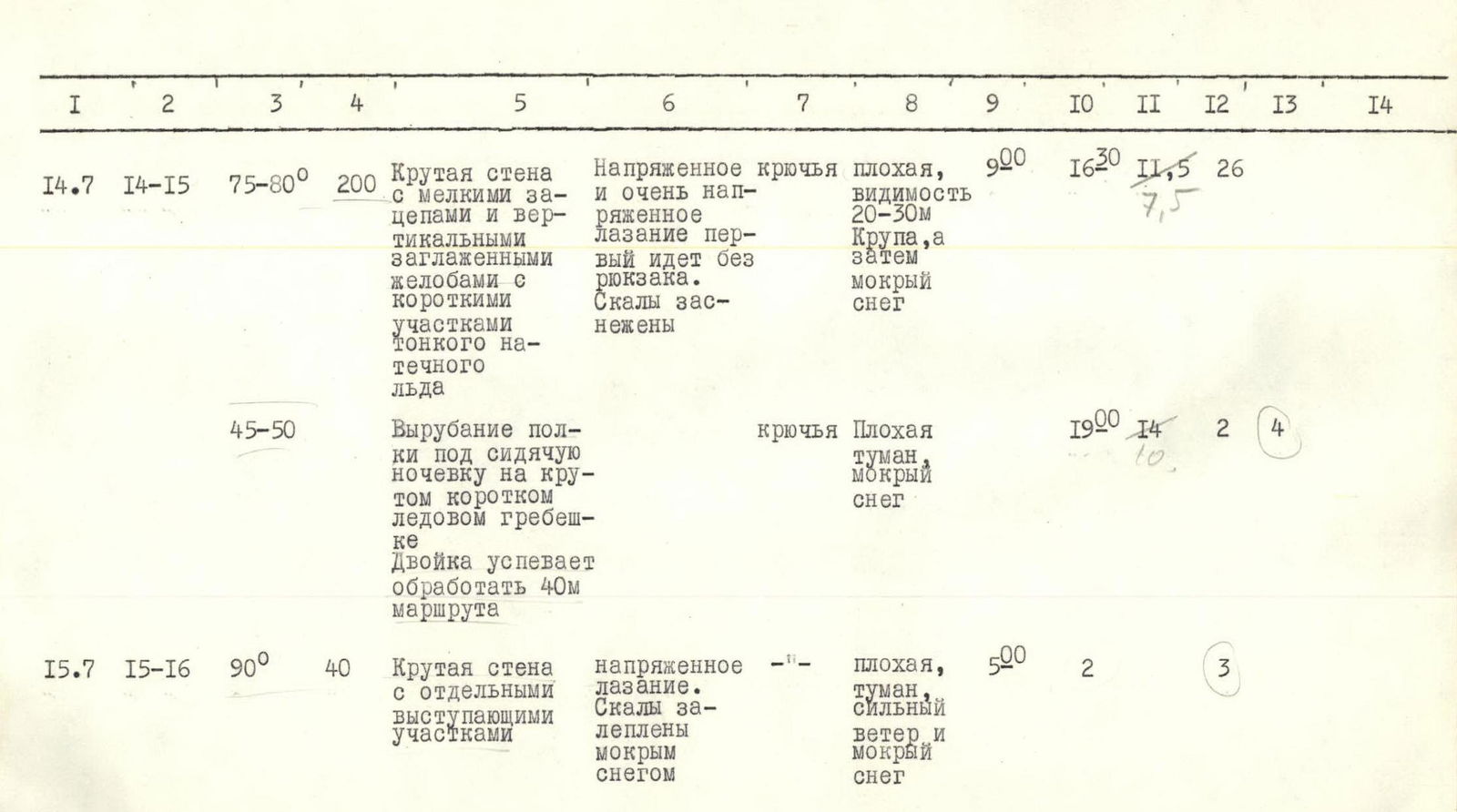
| 14.7 | 14–15 | 75–80° | 200 m | Steep wall with small handholds and vertical smoothed grooves with short sections of thin rimed ice | Tense and very tense climbing, first climber goes without backpack. Rocks are snow-covered | Hooks | Poor, visibility 20–30 m. Graupel, then wet snow | 9:00 | 16:30 | 11.5 | 26 | ||
| 45–50° | Clearing a platform for a sitting bivouac on a steep short ice ridge. Team manages to process 40 m of the route | Hooks | Poor, fog, wet snow | 19:00 | 14 | 2 | 4 | ||||||
| 15.7 | 15–16 | 90° | 40 m | Steep wall with individual protruding sections | Tense climbing. Rocks are coated with wet snow | Poor, strong wind and wet snow | 5:00 | 2 | 3 | ||||
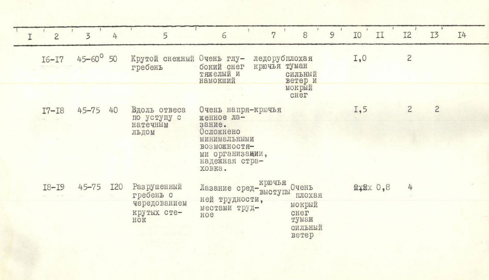
| 16–17 | 45–60° | 50 m | Steep snowy ridge | Very deep snow, heavy and wet | Ice axe, hooks | Poor, fog, strong wind and wet snow | 1.0 | 2 | |||||
| 17–18 | 45–75° | 40 m | Along a ledge with rimed ice | Very tense climbing. Complicated by minimal insurance possibilities, reliable insurance | Hooks | 1.5 | 2 | 2 | |||||
| 18–19 | 45–75° | 120 m | Destroyed ridge alternating with steep walls | Climbing of medium difficulty, partly challenging | Hooks, protrusions | Very poor, wet snow, fog, strong wind | 0.8 | 4 | |||||
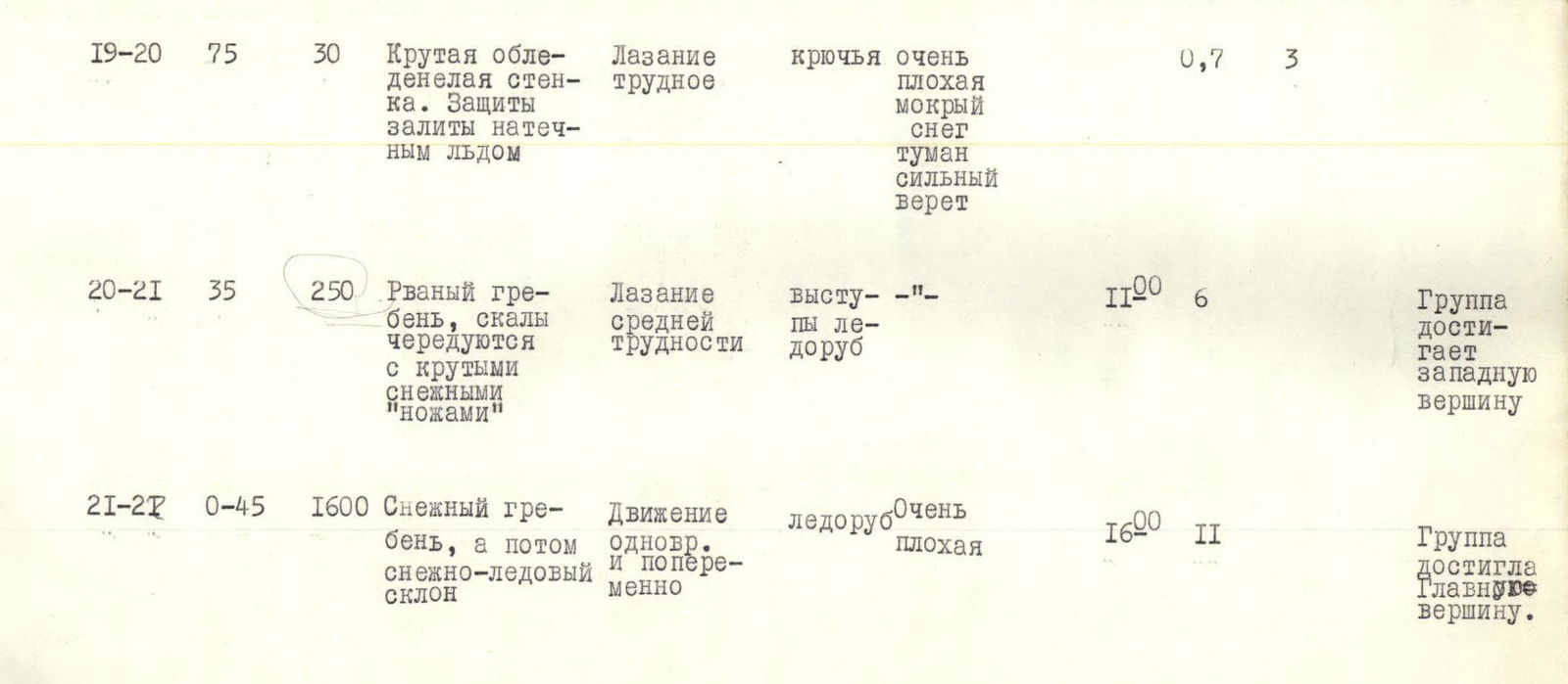
| 19–20 | 75° | 30 m | Steep icy wall. Insurance points are filled with rimed ice | Challenging climbing | Hooks | Very poor, wet snow, fog, strong wind | 0.7 | 3 | |||||
| 20–21 | 35° | 250 m | Jagged ridge, rocks alternating with steep snowy "knives" | Climbing of medium difficulty | Protrusions, ice axe | – | 11:00 | 6 | Group reaches the western peak | ||||
| 21–27 | 0–45° | 1600 m | Snowy ridge, then snow-ice slope | Simultaneous and alternating movement | Ice axe | Very poor | 16:00 | 11 | Group reached the Main peak. |
Overall assessment of the group's actions, characteristics of its participants
The ascent of the technically and psychologically challenging western ridge of Laboda Peak demonstrated that all group members:
- are proficient in snow and rock-ice techniques;
- skillfully utilize the arsenal of modern mountaineering technical means;
- possess sufficient tactical and organizational experience for complex wall and ridge routes of the highest difficulty category.
The main challenging sections of the route were traversed using free climbing, and only on the overhanging section of the first bastion were artificial points of support (ladders) used. The decisions made regarding the tempo and method of movement, organization of halts and bivouacs, and reconnaissance and processing of the route were correct and fully justified.
Conclusion
The route taken by the group to Laboda Peak via the western ridge from the Tsukhbuuni glacier is logical, objectively safe, and features a combined nature of obstacles (alternating ice, rocks, and snow).
The route has approximately 1200 m of elevation gain, with the main technical difficulties encountered when overcoming the rock segments of the first bastion and the northwest wall of Laboda Peak.
Route features:
- A limited number of locations suitable for bivouacs with tent setup, which imposes certain characteristics on the ascent tactics.
- During the ascent, 69 rock and 18 ice hooks were driven.
In terms of route length and the number of challenging sections, the ascent can be classified as category 5B complexity.
Ascent leader: Fedorov O.K.
Participants: Korsun A.G. Strikitsa N.I. Makhnovich L.A.
