Ascent Log
to the main peak of the Laboda massif (4314 m) via the Northwest ridge (left edge) 5B cat. diff.
- Technical category
- Main Caucasus Range, Digoria region, Laboda massif.
- Laboda peak 4314 m.
- The route is combined.
- Pitons hammered: rock — 132 (with stoppers) and 4 drilled; ice — 21; for creating ITO — 3.
- Number of climbing hours spent on ascent — 39, on descent — 6.
- Two overnight stays:
- On the ridge before the Utug rock pinnacle — sitting;
- On the snow-ice ridge before entering the ice couloir, 1 tent can be set up.
- Coach and ascent leader — Zaev E.F.
- The ascent took place from August 19 to 24, 1982.
Ascent team members Table № I
| № | Full Name | Year of Birth | Qualification | Profession | Nationality | Role in the Group |
|---|---|---|---|---|---|---|
| 1. | Zaev Z.F. | 1938 | MS | engineer, rus., leader | ||
| 2. | Alferov V.A. | 1953 | 1st sports category | engineer, rus., participant | ||
| 3. | Filyakin O.F. | 1949 | 1st sports category | engineer, rus., participant | ||
| 4. | Gostev L.D. | 1955 | 1st sports category | engineer, rus., participant | ||
| 5. | Kamzolov V.L. | 1952 | CMS | engineer, rus., participant | ||
| 6. | Zaeva G.L. | 1940 | MS | engineer, rus., observer | ||
| 7. | Popov A.S. | 1953 | 1st sports category | engineer, rus., observer | ||
| 8. | Meshcheryakov V.E. | 1954 | 1st sports category | engineer, rus., observer |
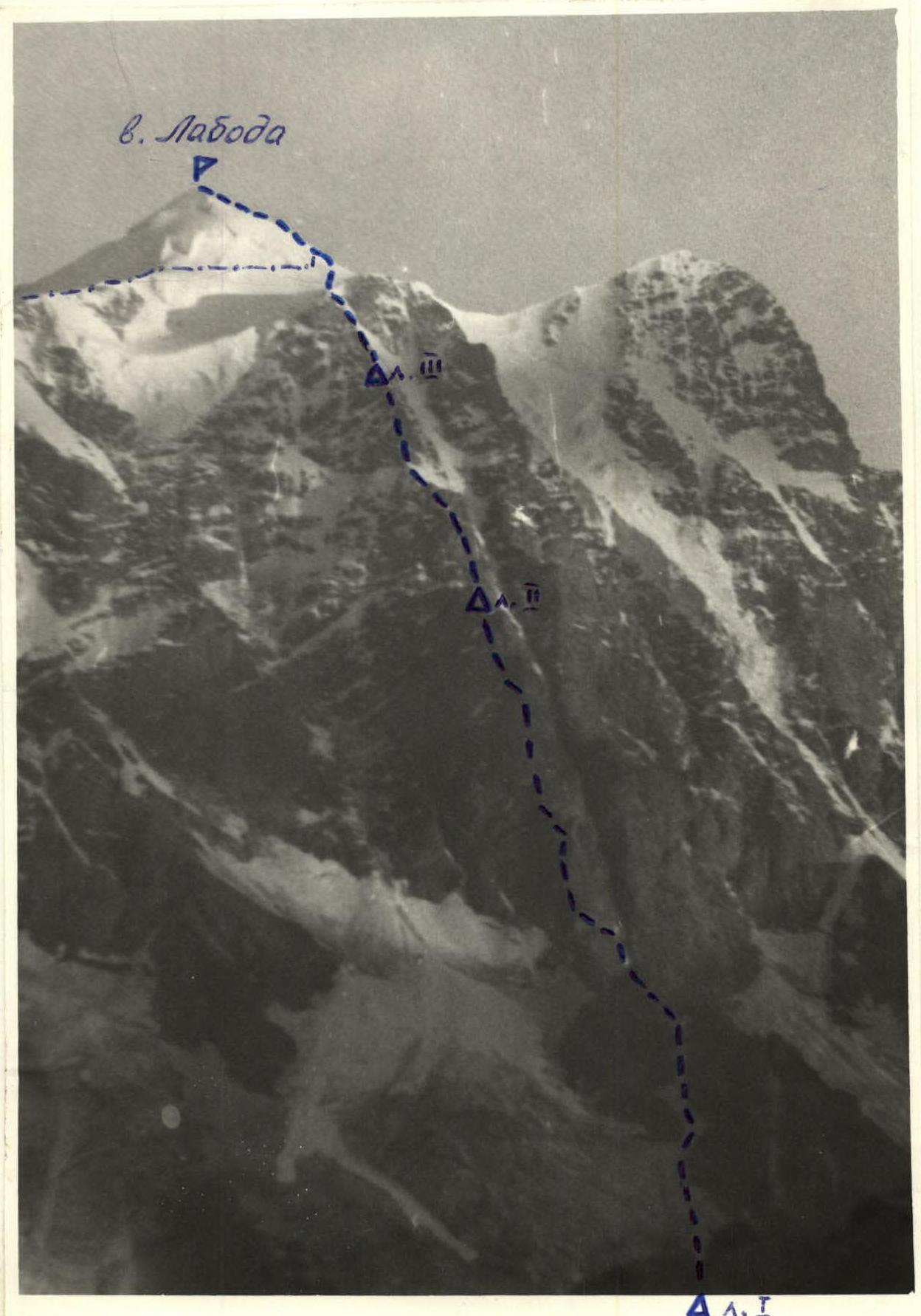
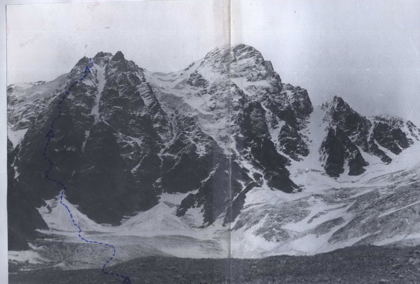
Table of main route characteristics.
Section characteristics — Pitons

| Date | Sections | Average steepness | Length | Terrain characteristics | Difficulty | Condition | Weather conditions | Rock | Ice | Drilled |
|---|---|---|---|---|---|---|---|---|---|---|
| 22.08.1982 g. | R0–R1 | 40–55° | 1,5 h | Glacier — bergschrund 5 m — ice couloir 40 m, traverse along rocks along quartz vein 40 m, up rocks to the saddle (1 cat. diff.) | III | satisfactory, good | 5 | 1 | – | |
| R2–R3 | 80–85° | 15 m | Chimney | IV | crumbling rocks | 2 | – | ladder | ||
| R3–R4 | 45–60° | 80 m | Traverse left along ledges | III | rock ledges | 1 | – | – | ||
| R4–R5 | 60–70° | 80 m | Rock walls turning into a chimney | IV | monolithic rocks | 6 | – | – | ||
| R5–R6 | 50–65° | 40 m | Bypass of the rock pinnacle on the left | IV | rocks of medium difficulty | belay on ledges | ||||
| R6–R7 | 65–80° | 40 m | Sharp rock ridge, at the end a platform (suitable place for overnight stay) | III–IV | rocks of medium difficulty | 2 | – | – | ||
| R7–R8 | 30° | 20 m | Snow ridge | III | dense snow | 1 | – | – | ||
| R8–R9 | 70–85° | 80 m | Rocks heavily covered with snow | IV | two clean rock outcrops | 4 | – | – | ||
| R9–R10 | 70–85° | 40 m | Traverse of medium and above medium difficulty | IV–V | rock wall with verglas | 3 | – | – | ||
| 23.02.1982 g. | R10–R11 | 80–85° | 120 m | Wall, wet rocks — traverse to an inclined ledge | IV–V | satisfactory, monolithic with individual loose rocks | sleet and wet snow | 6 | – | – |
| R11–R12 | 60–70° | 120 m | Bypass of the rock pinnacle on the left and then along the ridge | IV | crumbling rocks, partially covered with snow | sleet and wet snow | 12 | – | – | |
| R12–R13 | 40–50° | 70 m | Traverse left along rocks to the saddles of the lateral ridge. Here a platform was cleared and a sitting overnight stay was organized. | V | heavily crumbling rocks with verglas | sleet | 14 | – | – | |
| 24.08.1982 g. | R13–R14 | 90–95° | 6 m | Rock wall with overhang. Key section. | V–VI | monolithic rocks with verglas and overhang | 5 | – | ladder | |
| R14–R15 | 70° | 55 m | Ascent along the ridge to the "Utug". | V | monolithic rock slabs | 8 | – | – | ||
| R15–R16 | 90° | 90 m | Descent from the "Utug" via rappel and ascent from the inclined slab. | IV | snow-covered rocks | 6 | 1 | – | ||
| R16–R17 | 60° | 70 m | Snow-ice slope. Movement with crampons. | III–IV | rocks covered with thick verglas and snow | 4 | 1 | – | ||
| R17–R18 | 50–90° | 160 m | Movement along icy and snow-covered rocks: first up, then traverse and again vertically up under the overhanging tower. | V | icy rocks | 18 | – | – | ||
| R18–R19 | 40° | 40 m | Traverse | V | icy rocks | 6 | 2 | ladder | ||
| R19–R20 | 90° | 40 m | Narrow rock couloir with overhang. Very difficult climbing. Key section. | VI | sheer rocks with verglas | 6 | 2 | ladder | ||
| R20–R21 | 80–85° | 80 m | Vertically up along monolithic slabs. Very difficult climbing. Key section. | VI | sheer monolithic rock slabs with few holds and cracks | 9 | 1 | – | ||
| R21–R22 | 50–60° | 150 m | Movement along the ridge | III | snow-ice ridge with rock outcrops | belay via fixed rope | ||||
| R22–R23 | 30° | 100 m | Movement in three pitches | III | narrow snow saddle | belay via ice axe | ||||
| 24.08.1982 g. | R23–R24 | 50° | 120 m | Two ropes up and traverse right, bypassing numerous rock pinnacles | IV–V | very heavily crumbling rocks, snow-covered | 5 | – | – | |
| R24–R25 | 60–70° | 160 m | Movement along the ridge to the snow ridge. Here a snow ridge was cut and an overnight stay was organized. | IV | snow-covered rocks | 8 | – | – | ||
| R25–R26 | 60–75° | 240 m | Movement along a wide snow-ice couloir with 14-tooth crampons, ice axe, and ice hammer. | IV–V | ice covered with 5 cm of snow | 18 | – | |||
| R26–R27 | 25–30° | 40 min | Movement along a snow-ice plateau | II | deep snow | – | ||||
| R27–R28 | 45° | 45 m | Movement along an ice ridge. Descent via 2B cat. diff. | III | hard firn, ice | – |
Ascent Description
The Laboda peak is located in the Main Caucasus Range, in the "Digoria" region. It is situated between the Citeli peak (4245 m) to the southeast and Geze-tau (3525 m) to the west. The height of the main peak is 4314 m. This peak stands out for its beauty and inaccessibility from the north. Its massif is uniquely positioned and rises like a huge wall 1400 m above the absolutely flat green valley of the Urukh river.
From this side, there are four routes to the peak:
- Three 5B cat. diff.
- One 4B cat. diff. along the ridge.
Our team chose the route along the Northwest ridge (left edge) to the main peak of the Laboda massif for participation in the CS championship.
Preliminarily, the team underwent training and made several additional ascents at the "Torpedo" alpine camp. We climbed the Vils peak 5B cat. diff. and Pasianaria 5B cat. diff. During this period, the team tested new equipment manufactured before the season. Additionally, we practiced the ascent tactics, checked technical preparedness, psychological compatibility, and mutual understanding among the team members, and finalized the team composition for the ascent to Laboda peak.
Thus, by August 19, 1982, all preparatory work was completed, and the team consisting of 5 climbers and 3 observers departed from the "Torpedo" alpine camp to "Digoria" to undertake the ascent to the chosen peak.
Day 1. August 20, 1982. The team, having received all necessary instructions at the CSP of the "Digorsky" region, began the ascent. On the first day (6 climbing hours), after approaching, they set up an overnight stay at the terminal moraine of the Tsukhbuny glacier.
Day 2. August 21, 1982. was dedicated to studying the route.
Day 3. August 22, 1982. They set out from the overnight stay at 3:30, planning to pass the lower part of the couloir and bergschrund at dawn. Then they moved along the white quartz vein, exiting onto the ridge. They worked throughout the daylight hours until 20:00. The lead climbers changed throughout the day. By the end of the day, the weather began to deteriorate. Fog appeared, and sleet and wet snow started falling, significantly complicating the terrain and slowing down the team's progress. By the end of the day, they passed the second bastion and reached the rock pinnacle. Here, they leveled a small platform and set up a sitting overnight stay. Water and snow were almost absent, so they managed to prepare only half a cup of water each. Setting up an overnight stay elsewhere was not possible, as the ridge was steep and complex, and suitable platforms were only found in the first half of the day.
Day 4. August 23, 1982. They departed from the overnight stay at 6:30. Immediately from the overnight stay site, challenging climbing began — a 6-meter wall with an overhang. On this day, they had to pass the key section, so the lead climber, Alferov, put on crampons and wore them until section R22. The climbing was very technically and psychologically challenging due to:
- a lot of verglas;
- constant exposure to 400–600-meter drops to the base of the peak.
They used drilled pitons here. Further, the route's steepness decreased somewhat, but the snow covering the rock ledges and verglas made the route no less challenging. Additionally, the rocks became heavily crumbling, requiring increased attention and very careful route selection and belaying. After passing the key section, the lead climbers also changed. At 19:00, they reached the snow ridge. Here, they decided to set up an overnight stay. Within 1.5 hours, they:
- cleared a spot for the tent;
- organized fixed ropes;
- set up the tent.
Although the ridge allowed only enough space for the tent and dropped off on both sides with steep ice-snow couloirs, everyone managed to lie down and have plenty of tea.
Day 5. August 24, 1982. Wake-up at 4:30. The first rope team departed at 6:00. Movement was along an ice couloir lightly dusted with snow. The first climber went with ice crampons, an ice hammer, and a new-model ice axe. Good ice equipment and technique allowed them to quickly and reliably overcome the ice couloir and reach a snow saddle by 8:30. Then they moved with simultaneous belaying along the closed glacier and the snow-ice western ridge. They reached the summit at 20:30. The group descended via the 2B cat. diff. Tana-don route. They were at the CSP of the "Digorsky" region by 16:00. Here, a debriefing of the ascent took place. According to the team, the route:
- is technically complex;
- is sufficiently long (1400 m);
- requires high rock and ice climbing skills from the group;
- demands the ability to work on steep, crumbling rocks.
This route is one of the most challenging and beautiful routes of 5B cat. diff. It was first climbed by the MOS DSO "Zenit" team led by Penchuk V.L. in 1971.