34. Doppakh Eastern — Western (A. Zyuzin's combined route, 5A cat. dif.).
The path from the "Nakhashbita" meadow or the base camp on the right bank of the Psygansu river, not far from the tongue of the Nakhashbita glacier (4-8 people group), to the summit of Eastern Doppakh is described in routes 31, 32.
From Eastern Doppakh, descend in the direction of Central Doppakh along a 40-meter steep rocky ridge to a small saddle with a summit tower. From it, make a 30 m rappel to the left, then along a ledge on the left side of the tower, exit to the western ridge of the summit. Further, along rocks of medium difficulty, ascend 30 m along the ridge to the Black Gendarme. From it, make a 25 m rappel along steep, destroyed rocks to the ridge. From here, along simple, destroyed rocks of the ridge, passing a saddle, ascend to the Flat Gendarme. From the Gendarme, descend to an ice-snow saddle. From the saddle, along a simple 40-50-meter ice-snow ridge with sections of rocks, ascend to the Central Gendarme (Doppakh-3).
From Central Gendarme, descend along the ridge or ledges on its right side to the inclined northward Gendarme Tower. From under the Tower, make a 25 m rappel to the left. Bypassing the Gendarme, ascend to the saddle of the ridge. Further, along a steep, complex ridge, ascend to the Gendarme Kupol. From Kupol, descend along the ice-snow ridge to a snow plateau. Set up a bivouac on the plateau. From Eastern Doppakh, 6-8 hours.
Along the plateau, bypass the large Pre-summit Gendarme from the right and, overcoming the bergschrund, ascend 80 m along a steep ice-snow slope to the rocky base of Central Doppakh. Along difficult rocks of a 50-60-meter wall, ascend to the sharp ridge of the summit and along it, exit to Central Doppakh. From the plateau, 2-3 hours.
From the Central summit, make a 20 m rappel along slabs to the left of the Western ridge. Then, along rocks, exit to the Western ridge of the Central summit. Along the sharp, with a large number of gendarmes and smooth slabs, long, steep, snow-covered Western ridge, approach a rocky drop — a wall. Along the wall, make a rappel descent to a steep ice-snow slope and along it, descend to a saddle between Central and Western Doppakh (large cornices on the saddle). From the Central summit, 4-5 hours.
Having passed the saddle, ascend steeply along a 60-80-meter ice-snow slope on the right side of the Eastern ridge. Further, ascend along the right side of a 180-200-meter simple snow ridge to a small snow plateau and from it, overcoming the bergschrund, along a gentle 120-150-meter snow ridge — to the summit of Western Doppakh.
Set up a bivouac on a small plateau under the summit. From the previous bivouac, 6-9 hours.
Descend along the North-Western, North-Eastern, Southern, or Eastern ridges (see routes 27, 28, 24, 29, respectively).
The duration of the route is 5 days.
Doppakh
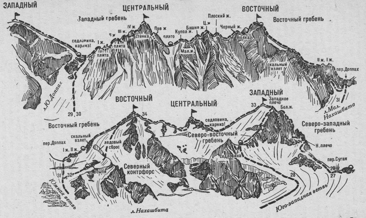
Fig. 8