
Moscow City Council
VSS "TRUD"
TRAVERSING THE BEZENGI WALL WITH ASCENT TO SHKHAra VIA THE NORTHERN RIDGE
1960
Leader: Gavrilov B. A. Participants:
- Moiseev Yu. A.
- Mosunov A. A.
- Chereshkin D. S.
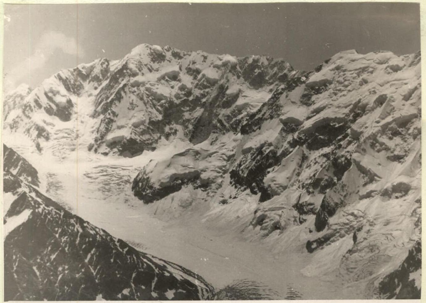
In July-August 1960, a gathering of qualified climbers from the Moscow City Council of VSS "Trud" was held at the "Bezengi" alpine camp. The plan included participating in the Moscow championship in the traverse class. The Bezengi Wall was chosen as the object, whose traverse with ascent to Shkhara via the northern ridge had only been done once before in 1948 by a group from VSS "Spartak" led by Honored Master of Sports Abalakov V. M.
A group of four was formed to accomplish the traverse. The group's composition:
- Gavrilov B. A. - Leader, Master of Sports of the USSR
- Moiseev Yu. A. - 1st category participant
- Mosunov A. A. - 1st category participant
- Chereshkin D. S. - 1st category participant
After training sessions on the rocks, the group carried out acclimatization ascents. They made product and fuel drops on the summits of East Djangi-Tau via the northern ridge (category 4B) and Gestola (category 3B).
The traverse of the wall was completed from July 13 to July 21 (from camp to camp). Below is a brief description of the traverse, taking into account that the Bezengi Wall has already been written about extensively in literature.
1st day. The group left the "Bezengi" alpine camp at 12:00 and stopped at the foot of Shkhara's northern ridge at 18:00. The approach first follows a trail to Missees-Kosh, then along the Ullu-Chiran glacier and its right-bank moraine to the "Austrian bivouac." From here, they crossed the glacier and reached the plateau in Shkhara's cirque.
2nd day. They left the bivouac at 4:00 AM. After an hour of ascent up a steep snowy slope, they approached the beginning of a diagonal rock ledge leading to the ridge. Here, they put on crampons, which were not removed until the end of the traverse.
After traversing 30 m along the ledge, they began ascending up frozen slabs, then moved right into an icy couloir with a steepness of about 60°.
The path continues through complex rocks leading to a sheer wall about 15 m high. Above it lies a jagged rocky ridge, whose steepness gradually increases. The rocks become more crumbly. They had to tackle "gendarmeries" head-on or bypass them on steep ice.
By 18:00, the group approached the foot of a steep internal angle formed by two sheer walls. With great difficulty, they managed to carve out an ice platform and set up a tent, securing it with pitons.
3rd day. Overcoming the frozen internal angle, they began ascending a 300-meter wall with an average steepness of about 60°. It took 6 hours to overcome it. In the upper part of the wall, they entered an ice-filled couloir, which they ascended after an hour of strenuous climbing, reaching a narrow snowy ridge of gentle steepness. The ridge gradually transitions into an icy slope, abutting steep frozen slabs. Overcoming the 150 m slab section took about 4 hours. Not reaching a rope's length to the ice overhangs looming over the ridge, they carved out a platform and set up a bivouac.
4th day. In the morning, the weather deteriorated, everything was shrouded in fog, but the group continued their ascent along the previously surveyed path. They overcame the icy overhang via a sheer 10-meter chute and reached a steep firn slope. After three hours of ascent along the slope, they reached the summit at 14:00 and were forced to stop for the night due to strong winds that made it impossible to move along the ridge.
Thus, it took 29 hours of work to ascend Shkhara via the ridge from the foot to the summit. The entire ascent was done with alternating rope protection. During this time, they used about 60 rock pitons and 15 ice screws.
5th day. On the 1st day of the traverse, they traversed the entire ridge of Main and West Shkhara.
The ridge is complex, with huge cornices hanging on the northern side and steep slopes descending to the south. They had to move very cautiously, carefully belaying each other. Bad weather (fog and graupel) significantly complicated their movement. Only by 20:00 did the group reach the snow plateau at the base of the rocky "saw" leading to Shota Rustaveli Peak ("Horse Teeth").
6th day. Early in the morning, they began overcoming the "saw." It's a jagged rocky ridge about 300 m long. The rocks are heavily snowed and destroyed.
- Between "gendarmeries" are deep gaps and narrow saddles.
By midday, they descended to a saddle before Shota Rustaveli Peak. Leaving their backpacks on the plateau, they ascended via a simple northern slope to the summit of Shota Rustaveli Peak. Descending from it, they began ascending a long icy slope to East Djangi-Tau.
The weather deteriorated again:
- It was snowing,
- a hurricane-force wind was blowing,
- upper cloud cover did not descend.
Replenishing their backpacks with supplies, they quickly descended to a col before Main Djangi-Tau. They managed to shelter from the hurricane-force wind in an ice grotto, where they struggled to set up a tent.
7th day. The weather was bad from the morning, with graupel falling, but the group continued the traverse. After ascending to Main Djangi-Tau via a simple ridge, they reached the West summit. Everything around was enveloped in fog. Visibility was reduced to 10-15 m, greatly complicating their movement. The further path was not visible, but after a brief discussion, they decided to continue moving along the ridge extending from West Djangi-Tau.
The rocky, heavily snowed ridge steeply dropped down into the fog. They began their descent. The rocks were icy, and they had to move with piton protection the entire time. The descent along the rocks lasted about 4 hours.
The fog became even denser. Heavy clouds were moving in from Svaneti. Occasionally, in breaks to the left below, they could see glaciers and, sunlit, green meadows of Svaneti. Up here, it was cold, windy, and graupel was falling.
Far below lay a snowy ridge, but descending along it was impossible due to the dense fog limiting visibility to no more than 5 m. They had to set up a platform on a snowy slope and stop for the night at 14:00.
8th day. The weather did not improve, so they had to wait it out.
9th day. The weather was excellent, with bright sunshine, allowing them to continue the traverse. After a quick descent along the snowy ridge, they approached the start of the "Djangi Saw" - a long, jagged ridge whose rocky "gendarmeries" were abundantly dusted with fresh snow.
They moved very cautiously - on both sides of the ridge hung very beautiful but extremely dangerous snow cornices. They preferred to move along the rocks where they could ensure reliable piton protection. They overcame about a dozen complex "gendarmeries" before reaching the shoulder of Katyn-Tau.
From here:
- they ascended to the summit via a simple ridge,
- descended a steep icy slope to a plateau.
In 1.5 hours, they crossed the plateau. By evening, the weather began to deteriorate again - a strong wind picked up. By 19:00:
- they ascended Gestola via a steep icy slope,
- retrieved their drop,
- began rapidly descending to platforms located on the shoulder of the summit.
At night, a strong wind arose, which collapsed their tent. But they only discovered this in the morning - everyone had slept so soundly that none of them felt the tent collapse.
10th day. Early in the morning, they continued their descent from Gestola. By 12:00, having passed Lyalver, the group descended to the Tsanner pass, and by 15:00, they were approaching the "Bezengi" camp.
Conclusion
The traverse was successfully completed by the group despite difficult meteorological conditions, relatively quickly (in 8 travel days) due to:
- good training of the group members before heading to the mountains;
- active acclimatization (the group completed a route to East Djangi-Tau via the ridge, category 4B, in 2 days from camp to camp);
- correctly developed movement tactics that combined reliable protection with rapid progress on complex sections;
- excellent interaction among all group members.
The group considers this route very interesting for traversal, requiring great physical endurance, good knowledge, and application of mountaineering techniques from its members.
Group participants:
| Section | Route Character | Length | Steepness | Time, h | Number of Pitons |
|---|---|---|---|---|---|
| R1–R2 | Snowy slope | 200 m | 30–35° | 1 | - |
| R2–R3 | Rocky ledge | 30 m | - | 1 | 2 rock |
| R3–R4 | Slabs | 40 m | 45–50° | 1.5 | 4 rock |
| R4–R5 | Icy couloir | 120 m | 60° | 3 | 3 ice |
| R5–R6 | Rocky wall | 15 m | 80–85° | 1.5 | 4 rock |
| R6–R7 | Rocky-icy ridge | 370 m | 40–60° | 5 | 5 rock, 2 ice |
| R7 | Bivouac | - | - | - | - |
| R7–R8 | Internal rocky angle | 60 m | 60–75° | 1.5 | 6 rock, 1 ice |
| R8–R9 | Rocky wall | 300 m | 60° | 6 | 18 rock, 2 ice |
| R9 | Icy couloir | 80 m | 70° | 1 | 3 rock, 3 ice |
| R9–R10 | Snowy ridge | 150 m | 10° | 1 | 3 rock, 3 ice |
| R10–R11 | Frozen slabs | 150 m | 30–60° | 4 | 12 rock, 3 ice |
| R11 | Bivouac | - | - | - | - |
| R11–R12 | Icy chute | 10 m | 80–90° | 1 | 4 ice |
| R12–R13 | Icy-snowy slope | 350 m | 40–50° | 3 | - |
| R13 | Bivouac | - | - | - | - |
| R13–R14 | Icy-snowy ridge | 5 km | - | 11 | 5 ice |
| R14 | Bivouac | - | - | - | - |
| R14–R15 | Rocky ridge | 300 m | - | 3.5 | 8 rock |
| R15–R16 | Snowy slope | 100 m | 30° | 1 | - |
| R16–R18 | Icy slopes | 500 m | 40° | 2.5 | - |
| R18 | Bivouac | - | - | - | - |
| R18–R19 | Snowy-icy ridge | 1 km | - | 2 | - |
| R19–R20 | Rocky ridge | 200 m | 45–55° | 4 | 5 rock |
| R20 | Bivouac | - | - | - | - |
| R20–R21 | Snowy ridge | 100 m | - | 0.5 | - |
| R21–R22 | Rocky ridge | 300 m | - | 3 | 3 rock |
| R22–R23 | Icy slope with rocky outcrops | 250 m | 40° | 2 | 4 rock, 2 ice |
| R23–R24 | Snowy ridge | 200 m | - | 1 | - |
| R24–R25 | Icy slope | 250 m | 45° | 1.5 | 4 ice |
| R25–R26 | Katyn plateau | 1 km | - | 1.5 | - |
| R26–R27 | Icy-snowy slope | 150 m | 30° | 1 | - |
| R27–R28 | Rocky ridge and snowy fields | 400 m | 15–20° | 1.5 | - |
| R28 | Bivouac | - | - | - | - |
| R28–R29 | Snowy ridge | 1 km | - | 2 | - |
| R29–R30 | Rocky ridge | 800 m | 40–45° | 1 | 1 rock |
| R30 | Tsanner pass | - | - | - | - |
Comments
Sign in to leave a comment