
Ascent Passport
- Class — technical
- Central Caucasus, Bezengi region 2.5
- Western Shkhara (5057 m) via the north face of the eastern ridge spur, second ascent of the route
- Proposed difficulty category — 6
- Height difference — 1157 m (3900–5057), wall length — 1730 m, length of sections with 5–6 difficulty category — 660 m (3975–4570, 4780–4890), average steepness of main sections — 64–67°, of which 6th category — 320 m (4280–4570, 4780–4890), 77–79°
- Pitons driven and chocks used:
| Rock pitons | Chocks | Bolts | Ice screws |
|---|---|---|---|
| 116 | 51 | 5 | 76 |
| 28 | 13 | 5 | 21 |
- Climbing hours — 88, days — 8, of which:
- ascent — 61 hours, 6 days,
- descent — 17 hours, 2 days
- Bivouacs: 1–2 — in a tent, snow slope; 3 — sitting, separate; 4–5 — in a tent, ice slope; 6 — in a bergschrund; 7 — in a cave
- Team from "Elbrus" alpine camp Anatoly Blankovsky — Master of Sports, leader Vasily Boyko — Candidate for Master of Sports Mikhail Golubenko — Master of Sports Vladimir Kushnarev — Candidate for Master of Sports Stanislav Belousov — Candidate for Master of Sports
- Coach — Boris Shaposhnikov
- Approach to the route — July 15, 1982 Summit — July 20, 1982 Return — July 22, 1982
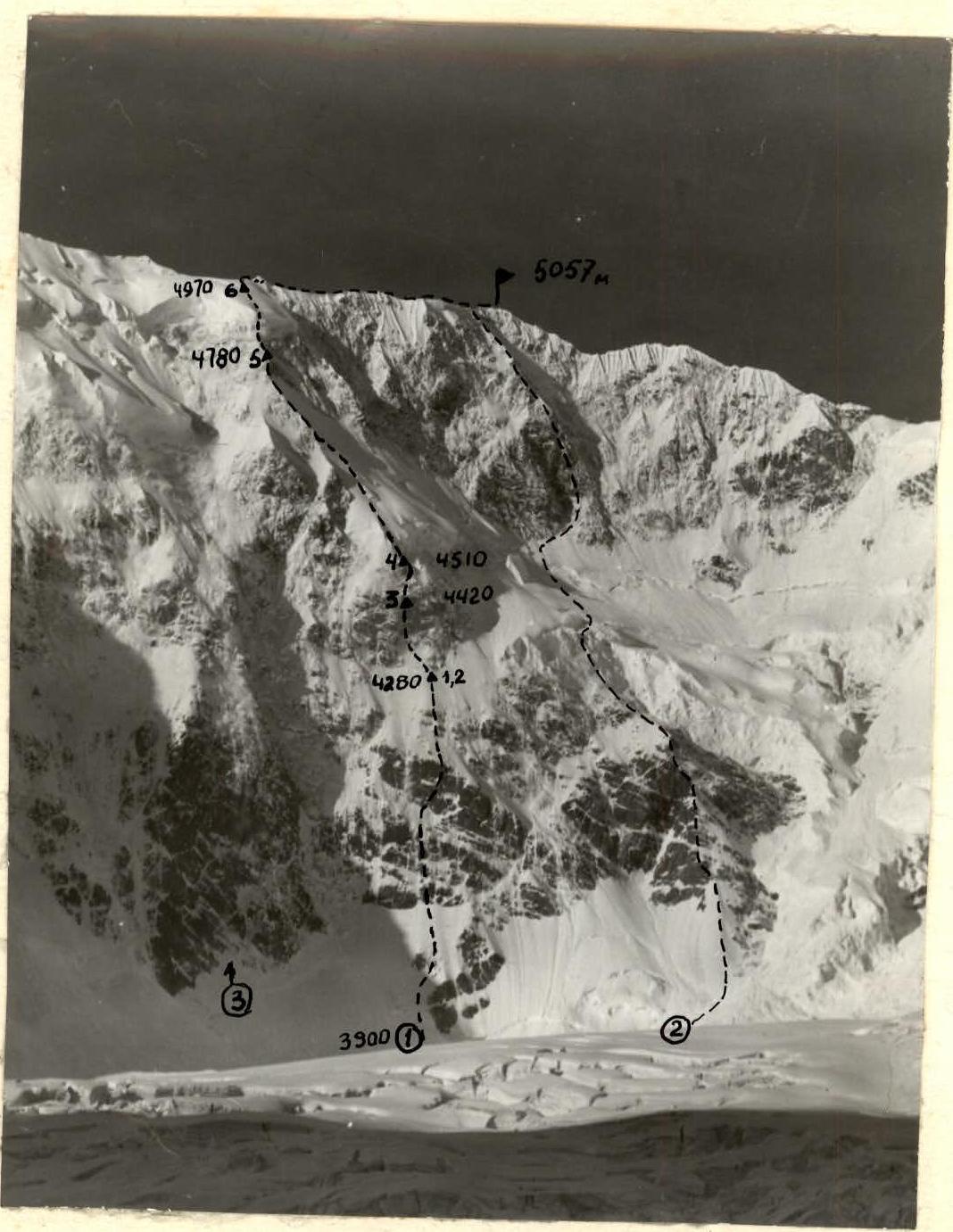
Photo # 1. Western Shkhara summit from the north. Photo taken from "Jangi-kosh" hut (3860 m) on July 23, 1982, distance to the wall ~ 3 km. Lens — U-23. Focal length — 110. (1) — route climbed by the team from "Elbrus" alpine camp in 1982 (2) — route of the team from "Bezengi" alpine camp in 1980 (3) — "bottle" spur.

Photo # 2. Profile of the North face of Western Shkhara from the right, N-E. Photo taken from the N-E ridge of Eastern Jangi-Tau on August 15, 1980, at a height of ~4600 m, distance to the route ~1 km.
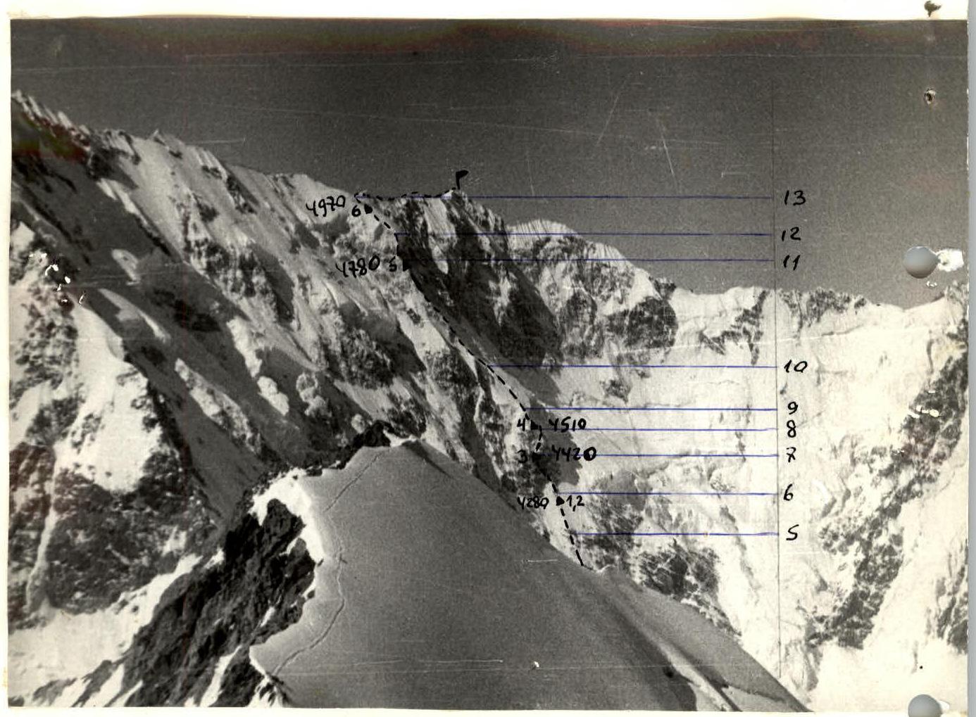
Photo # 3. Profile of the North face of Western Shkhara from the left, N-E. Photo taken from the 10th ridge of Western Mizhirgi at a height of ~4300 m, July 1971, distance ~5 km. Lens — Jupiter-8. Focal length — 50 mm.
Tactical Actions of the Team
- Route planning.
The ice walls — barriers, especially the first one, dominating the most technically challenging section of the route R0–R8, had a decisive influence on the choice of path. Observations from previous years (while working as instructors at "Bezengi" alpine camp) and the experience of the first ascenders showed that in this seemingly impassable and objectively dangerous place, there is a safe path. And this path lies in a rather narrow corridor, running under the continuation of the ridges on which the ice barriers rest, as the ridges throw falling ice to the sides. Observation for three days (July 12–14) and reconnaissance of the start of the route before the ascent allowed to уточнить the path of ascent.
- Choosing bivouac locations.
According to the team, the success of the ascent was largely determined by the location of the first bivouac, as there are no convenient and fully protected places for overnight stays on the R0–R5 section. On the R5–R6 ridge, a bivouac can be set up almost anywhere, but in case of snowfall, the slope becomes avalanche-prone.
Adjustment of the tactical plan (a bivouac was planned between the I-st and II-nd rock belts – R2–R3) became possible both as a result of a fairly fast pace of advancement on the R0–R3 section, and due to fear of worsening weather (which was confirmed that same night).
Bivouacs # 4, 5, and 6 were planned, but bivouac # 3 was a find, as there is no safer place on the wall of the III-rd rock belt — a ledge protected by an overhang, although not very comfortable (sleeping separately). You feel especially calm in this place during bad weather.
- Weather conditions.
The R6–R8 section with the first four bivouacs was climbed in conditions of practically non-stop bad weather — snow, at times hurricane-force wind, thunderstorms. The wait on July 16 showed that the bivouac under the wall does not preserve strength — continuous struggle with snow falling from the wall, both tiring and depressing. In three days — July 16, 17, and 18 — only 230 m were covered, but these days and nights were decisive both psychologically and technically — the II-nd rock belt was passed.
Ahead, under Main Shkhara, we were still waiting for bad weather on July 21, which forced us to dig a cave already at noon and take shelter in it — no tent could withstand such gusts of wind, but this was still a ridge, not a wall.
- Key points of the route.
These are the III-rd rock belt and both ice barriers. Of these three sections, I would like to highlight the first one. Monolithic and icy rocks, steepness and lack of holds, compounded by bad weather, are the difficulties that an alpinist must rely mainly on free climbing technique to overcome. The technique of overcoming ice walls at present (with the help of ice axes) combined with the experience of climbing Western Shkhara in 1980 facilitated the task, although it did not eliminate the psychological stress associated with the nature of the ice (fragile, hard), steepness, length, and the feeling of being on an ice serac, not on a glacier.
- Descent route and retreat path.
We planned two options for descending from the summit: the main one — to the east towards Main Shkhara, the backup — to the west towards Eastern Jangi-Tau. The main option was taken, technically and physically more challenging, and, as it seems to us, more logical and beautiful, as in this case, the ascent up the north wall was combined with a traverse of the entire Shkhara massif.
In bad weather (heavy snowfall), the team must be:
- physically prepared
- technically prepared
- mentally prepared
to move only upwards after passing the snow slope R5–R6; from the II-nd rock belt, you need to descend along the ascent path.
- Rope team work, leads.
There were no clearly defined rope teams in the team. The role of lead on certain sections was performed by all team members.
- July 15 — Golubenko, Blankovsky: R0–R6
- July 17 — Boyko, Blankovsky: R6–R7
- July 18 — Golubenko, Belousov: R7–R9
- July 19 — Kushnarev, Boyko: R9–R11
- July 20 — Belousov: R11–R13 July 21 and 22 — alternately all team members.
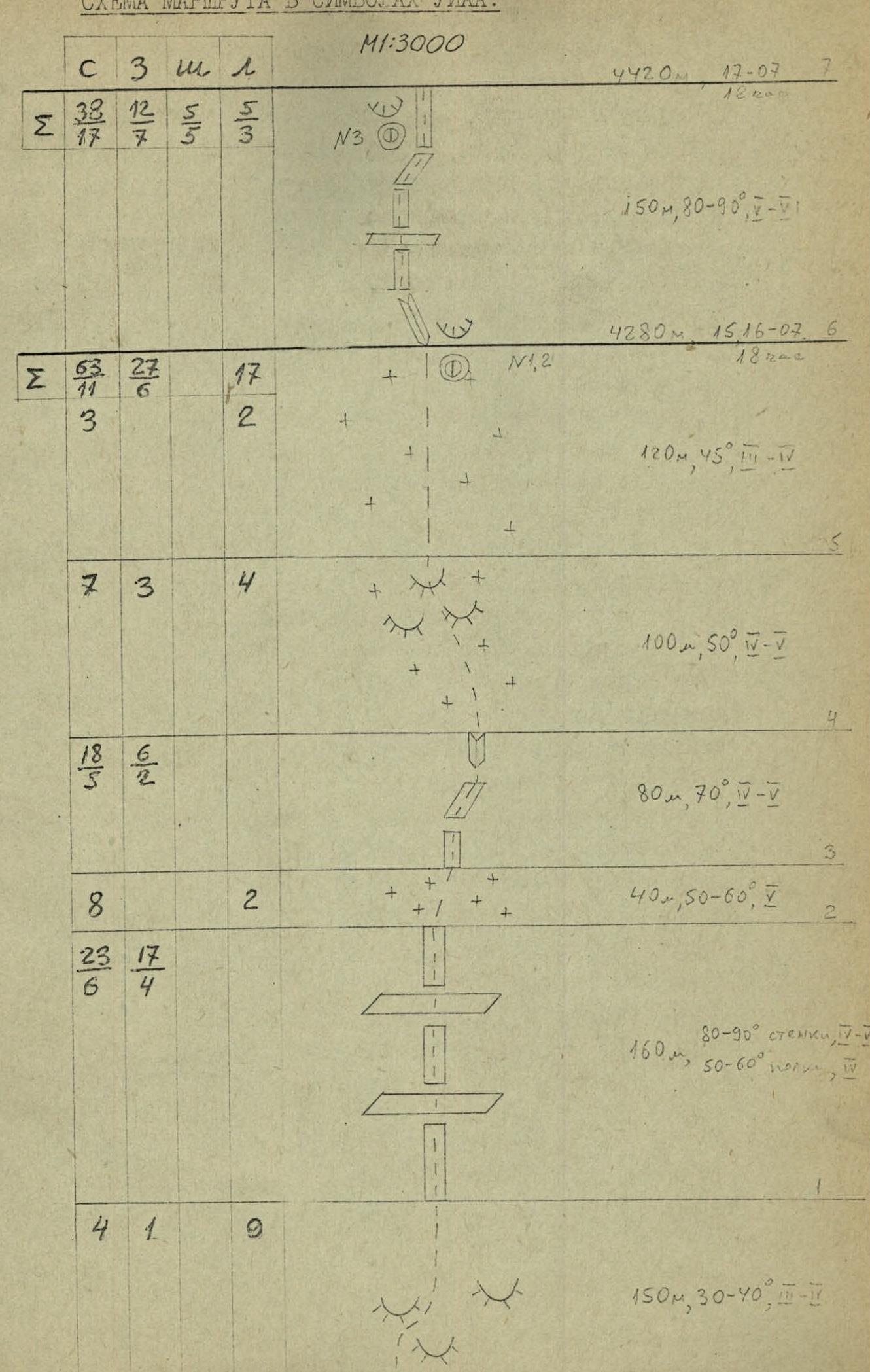
ROUTE SCHEME IN UIAA SYMBOLS.
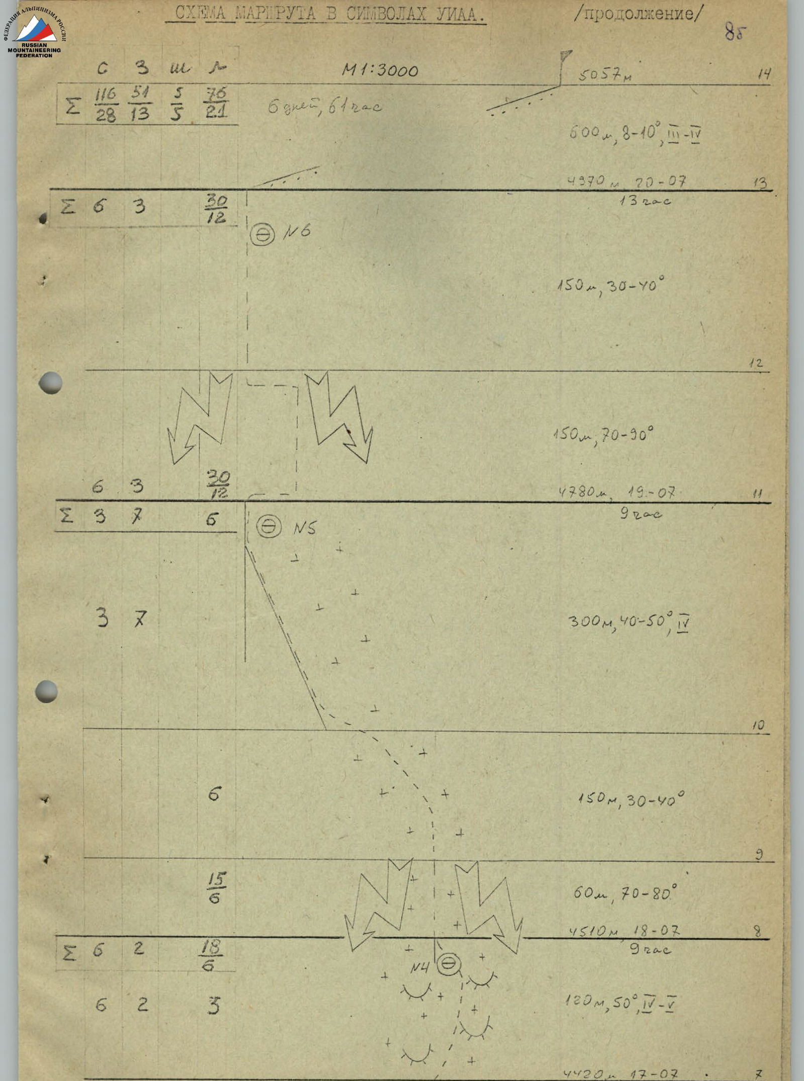
ROUTE SCHEME IN UIAA SYMBOLS. (Continued)
Description of the Route by Sections
From "Jangi-kosh" hut to the start of the route 1.5–2 hours.
The landmark for the start of the route is a group of rocky outcrops to the right of the "bottle" spur.
After the bergschrund, the climb goes left-up-right between the left rocky outcrop and the main massif of outcrops, then straight up the ice to the rocks (section R0–R1).
The I-st rock belt (R1–R2) is a combination of steep rocky walls and ice ledges. A narrow ice saddle (R2–R3) leads to the second rock belt (R3–R4), which is climbed on the right side. Next is an ice slope with rock outcrops (R4–R5), followed by a not clearly defined snow ridge (R5–R6), abutting against the sheer wall of the III-rd rock belt (R6–R7).
On the R5–R6 section, for the first time, you can organize a convenient bivouac — best at the foot of the wall. The wall on the right and left has a pronounced relief, the route goes first on the left side, and then traverses to the right under the overhanging rocks. The key point of the route is monolithic rocks with a small number of holds, filled with flow ice. Under the overhangs, you can organize a sitting, protected from falling ice debris, bivouac.
Further up the ice slope with rock outcrops (R7–R8) left-up-right to a snow ridge under the wall of the I-st ice barrier (a convenient place for an overnight stay, a platform to be cut out in the lower part of the ridge).
In 1982, the ice wall (R8–R9) was climbed somewhat to the right of the ridge. Above the wall is a simple snow slope (R9–R10), leading to seracs — if necessary, a bivouac can be organized here, then the snow turns into ice. From the serac up-left to the ridge of the spur (R10–R11), leading under the II-nd ice barrier. Under the ice wall, the ridge becomes snow-icy, setting up a bivouac in this place requires significant physical effort.
The second ice wall (R11–R12) is higher and steeper than the first. In 1982, the wall was climbed as follows:
- a rope to the right along the rocks under the base of the wall,
- then straight on the ice under the "roof" of the barrier,
- finally, left up along the ledge to the snow slope.
In the upper part, the ice wall is covered with a layer (irna). The relief of the wall is pronounced, without fractures, the ice is dense, brittle.
The snow slope (R12–R13) is steep at first, then becomes more gentle, leading to the ridge of the Shkhara massif. Not reaching the ridge, in the bergschrund — a convenient, wind-protected bivouac.
Further along the relief (R13–R14) with cornices on the north side — ascent to the summit of Western Shkhara. Descent to the base camp either:
- towards Main Shkhara,
- towards Eastern Jangi-Tau.
Recommendations for climbers:
- When choosing a route on the section (R0–R6), one should be wary of falling ice debris from the I-st ice barrier — the path should be laid in a rather narrow corridor, the axis of which is a conditional line running along the snow ridge leading to the II-nd rock belt, in the direction of the left edge of the main massif of outcrops at the beginning of the route. The wall of the III-rd rock belt should be climbed:
- through the center, or
- slightly to the left, entering the center of the wall again in the upper part.
- In case of sharp deterioration in weather on the R0–R4 section, you should go down; the snow slope R5–R6 after heavy snowfall can be avalanche-prone. After reaching the snow slope R9–R10 above the first ice barrier, you should go to the rocks of the spur R10–R11 as soon as possible.
- There are no safe places for overnight stays on the R0–R5 section, but a bivouac under the wall of the III-rd rock belt is safe, but in case of snowfall, it gets covered with snow falling from the wall. In addition to the bivouac locations used by the team, a bivouac can be recommended in the area of the serac R9–R10.
Comments
Sign in to leave a comment