MOUNTAINEERING
-
Technical class.
-
Caucasus, Bezengi gorge.
-
Main Shkhara, center of the NE wall.
-
Proposed - 5B cat. sl. first ascent.
-
Elevation gain: 1145 m, length: 1640 m.
Length of sections with 5-6 cat. sl.: 790 m. Average steepness of the main part of the route: 57°, including 6 cat. sl.: 62° (4360 m–4550 m).
- Pitons driven:
rock 36/2, chocks 49/3, ice screws: 60/6
- Team's travel hours - 26 and days - 3.
- Overnight stays: 1st without a tent, separated (three - lying on a rock slab, two - individually on ice-cut shelves); 2nd - tented, cut into a snow-ice ridge for 5 people).
- Leader: Leonid Borisovich Volkov, Master of Sports.
Team members:
- Fedor Petrovich Mityukhin, Master of Sports
- Alexander Pavlovich Sushko, Candidate for Master of Sports
- Alexander Nikolaevich Venslavovsky, Candidate for Master of Sports
- Andrey Maksimovich Mezentsev, Candidate for Master of Sports
- Coach: Leonid Gavrilovich Tabolov, Candidate for Master of Sports.
- Approach to the route: July 24, 1987.
Summit - July 26. Return - July 26.
- Organization: AU SB "Tsey".

Photo 1. Main Shkhara NE wall. Shooting point 1. Lens "Industar-50". F = 50 mm. h = 4500 m. l = 1.5 km. Date and time of shooting - July 26, 1987, 16:00. Group's path - Baudisch-Romanenko route 5B cat. sl.
A.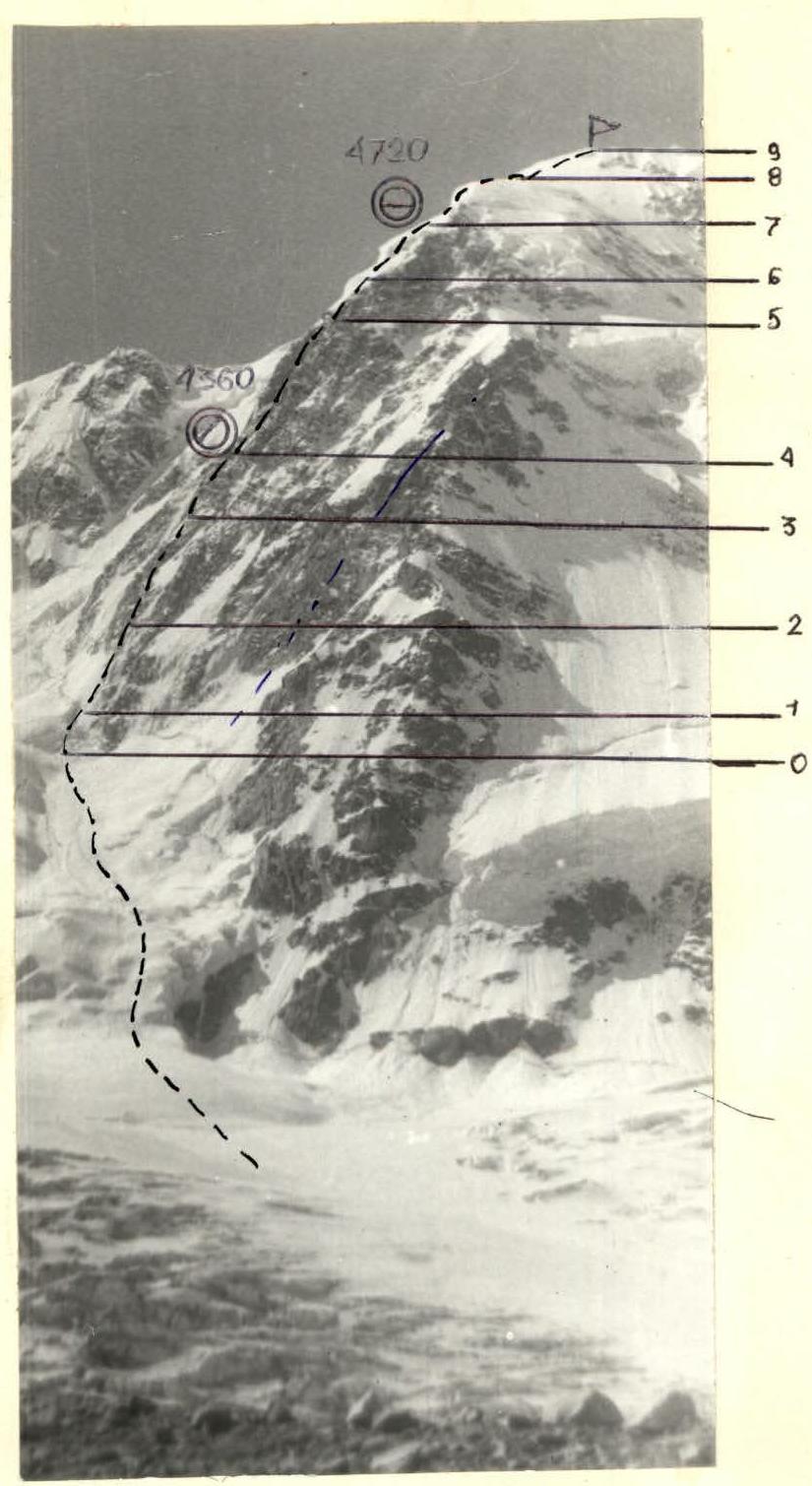
Photo 2. Profile of the wall from the right. Shooting point 2. July 27, 1987, 10:00. Lens "Industar-50", F = 50 mm. l ≈ 5 km; h = 3200 m.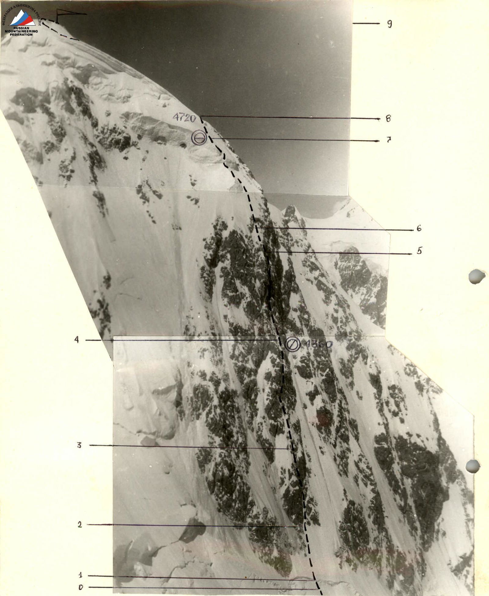
Photo 3. Profile of the route from the right. Left. Shooting point 3. July 17, 1987, 13:00. Lens "Industar-50". F = 50 mm. l = 1.5 km. h = 4800 m.
The characteristics of the Bezengi region (high absolute altitude, significant temperature fluctuations, powerful glaciation), as well as the specifics of Shkhara peak and its NE wall identified during preliminary reconnaissance, observations, and consultations (steepness and nature of rocks; solar exposure, presence of snow-ice dumps in the pre-summit part, likely absence of tent bivouac sites on the wall) - determined the tactical ascent scheme:
- Maximum rapid passage through the lower part of the wall.
- Independent work of rope teams (using left-behind pitons).
- Passage through the rocky part of the wall with one overnight stay (possibly separated).
- Planning a bivouac under the cover of an overhanging bastion.
- Preference for various forms of snow-ice relief for movement and organization of belays.
Taking into account the team's previous ascent experience in the Bezengi region (Dykh-Tau via NE ridge, 1983; Krumkol with a traverse to Main Dykh-Tau, 1986), massive sections of flowstone ice and rocks covered with a thin layer of ice were expected on Shkhara's NE wall. Therefore, special equipment was designed and tested (AU SB "Tsey", February 1987) for ice-snow terrain:
- short ice axes with increased inner diameter and small thread pitch for belaying on flowstone ice;
- ice screws of greater length and diameter for belaying on granular ice;
- original design ice screws for moving on hard flowstone ice;
- ice screws with "blades" for moving and belaying on complex, porous ice, and dense granular snow;
- collapsible shovel for belaying on snow and organizing bivouacs.
The ascent was completed without deviations from the planned route and tactical plan. The first night's stay, despite being uncomfortable, was set up in a safe location, under the cover of the overhanging bastion's rocks.
All team members worked as lead climbers in rope teams. There were no falls or injuries.
| Rock | Ice | Chocks | Travel hours | Section # | Section length | Steepness | Category of difficulty |
|---|---|---|---|---|---|---|---|
| 13 | R4 | ||||||
| 8 | 6 | 14/2 | R3 | 160 | 58° | 5 | |
| 5 | 12/2 | 8 | R2 | 170 | 52° | 5 | |
| – | 18 | – | R1 | 180 | 45° | 5 | |
| – | – | – | R0 | 20 | 35° | 3 |
| Total on the route | Section # | Section length | Steepness | Category of difficulty | |||
|---|---|---|---|---|---|---|---|
| 36/2 | 60/6 | 49/3 | 26 | ||||
| – | – | – | R8 | 600 | 30° | 2-3 | |
| 4 | 2 | 2 | Tented overnight stay | R7 | 80 | 40° | 1 |
| R7 | 200 | 40° | 1 | ||||
| – | 9 | – | R6 | 200 | 40° | 1 | |
| 6 | 5 | 7 | R5 | 80 | 50° | 5 | |
| 13/2 | 8/4 | 18/1 | R4 | 200 | 62° | 5 |
R0–R1 (20 m)
Up a steep snowy slope under the overhanging wall of the bergschrund. In the upper part - a 3-meter layer of dry snow, making it impossible to use ice screws. Overcome with the help of:
- a diagonal trench,
- then using ladders fixed to a snow shovel and ice axe.
R1–R2 (180 m)
Ascent up a snowy slope, then up an ice-snow couloir to the left of the smoothed rocks of the lower part of the counterfort. Belay:
- first through an ice axe with a snow shovel,
- then on ice screws.
R2–R3 (170 m)
Exit up steep flowstone ice (60°) onto the crest of the counterfort and movement along it to the 1st rise of the wall. Rocks are heavily snow-covered, with ice underneath. Movement in crampons, belay through ice screws.
R3–R4 (160 m)
The wall's rise is initially composed of monolithic rocks with good holds. The first two ropes - climbing without crampons, movement along shelves, then up a steep internal corner with flowstone ice.
Further:
- rocks are smoothed, covered with flowstone ice;
- movement in crampons;
- use of ladders.
After 2-3 ropes, the wall becomes less steep, with more flowstone ice. Approach to the second rise of the wall.
R4–R5 (200 m)
The second rise of the wall is composed of massive blocks of rock, interspersed with broad ice flows. Above, yellow rocks of the "bastion" overhang. Climbing is very difficult, movement in crampons, ladders, ice screws.
Throughout the entire route, there are no suitable places for a tented bivouac, so 40 m before reaching the "bastion" rocks, the group cut out places in the ice for a separated overnight stay:
- a shelf for three people;
- two shelves for individual placement.
Approach to the bastion (40 m) and further - bypassing the overhanging rocks from right to left. Climbing is very difficult, with alternating:
- smooth monolithic slabs;
- steep internal corners;
- ice chimneys.
Exit onto the bastion in the upper part - via an icicle of flowstone ice.
R5–R6 (80 m)
Further, the rocks become less steep, but heavily snow-covered. Belay organization is complicated by snow cover and lack of ice. Exit onto the snow-ice dome of the summit under the first (triangular) ice dump.
R6–R7 (200 m)
Up a steep snowy slope (belay via an ice axe with a shovel) exit to the 1st dump and, bypassing it on the right, straight-up exit under the second ice dump and along it to the right-up, crossing the slope - couloir, exit onto a snow-covered ridge - a snowdrift with a steepness of 30-35°. Organization of a site for a tented bivouac. Hanging two ropes along the snowdrift to exit onto a rocky rise.
R7–R8 (80 m)
Along the ridge of the snowdrift, movement along fixed ropes to the rise of rocks, crossing it, and exit onto the snow-ice field of the upper part of Shkhara's dome.
R8–R9 (500-600 m)
Simultaneous movement towards the summit to a depression. Left along the bergschrund - exit onto the ridge and along it - to the summit.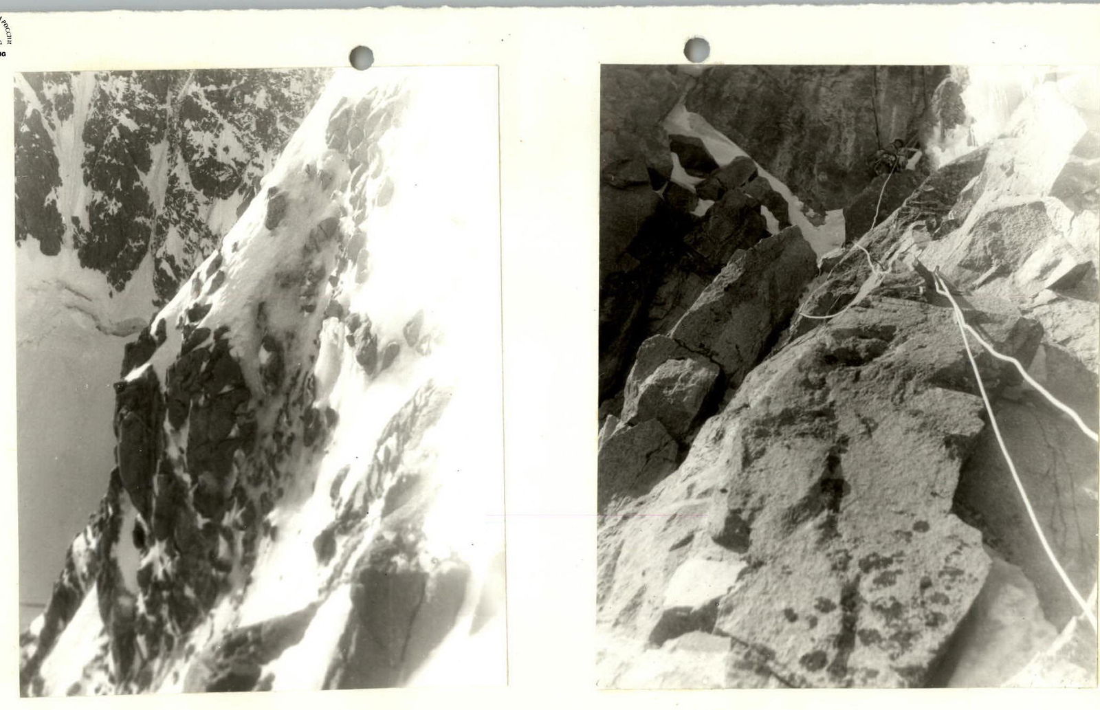
Photo 10. Character of rocks on section R4–R5.
Photo 11. Approach to the internal corner (R4–R5).
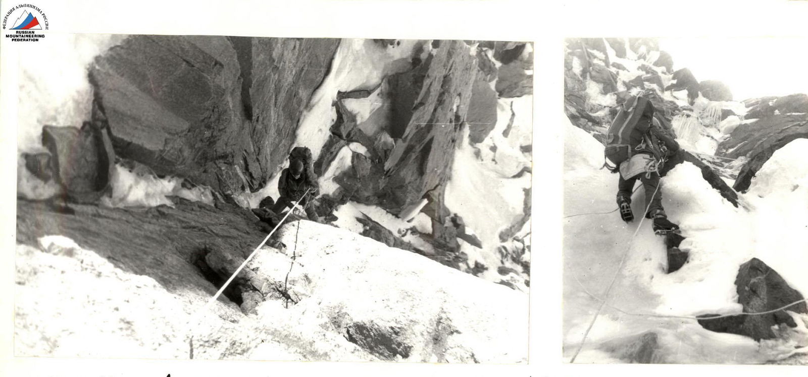
Photo 12. Climbing in the internal corner (R4–R5).
Photo 13. Approach to the ice "icicle" (R4–R5).