Ascent Passport
I. Class of ice and snow ascents
- Ascent area: Central Caucasus, Bezengi
- Peak Shota Rustaveli - 4960 m via North face (route by A. V. Laletin)
- 5B category, fourth ascent
- Total height difference of the route is 1360 m. Height difference of the wall section is 1200 m. Average steepness of the wall section is 48°. Route length is 2565 m. Length of the wall section is 1755 m. Length of sections with 5-6 category difficulty is 1445 m.
- Pitons hammered:
Ice pitons for belay - 250, ITO - 9. Rock pitons for belay - 13.
- Total climbing hours - 25.
- Overnights - 2. One of them during descent. Both were comfortable.
- Team composition:
- Opoitsev N. A. - Candidate Master of Sports, captain
- Kalagin Yu. G. - Candidate Master of Sports, participant
- Guryev G. M. - Candidate Master of Sports
- Kalyuzhny V. I. - Candidate Master of Sports
- Senior team coach - Master of Sports Monaenkov E. I.
- Date of departure for the route - August 7, 1986.
Date of return from the route - August 9, 1986.
General photo of the summit
Legend: – Team's route – Overnight locations
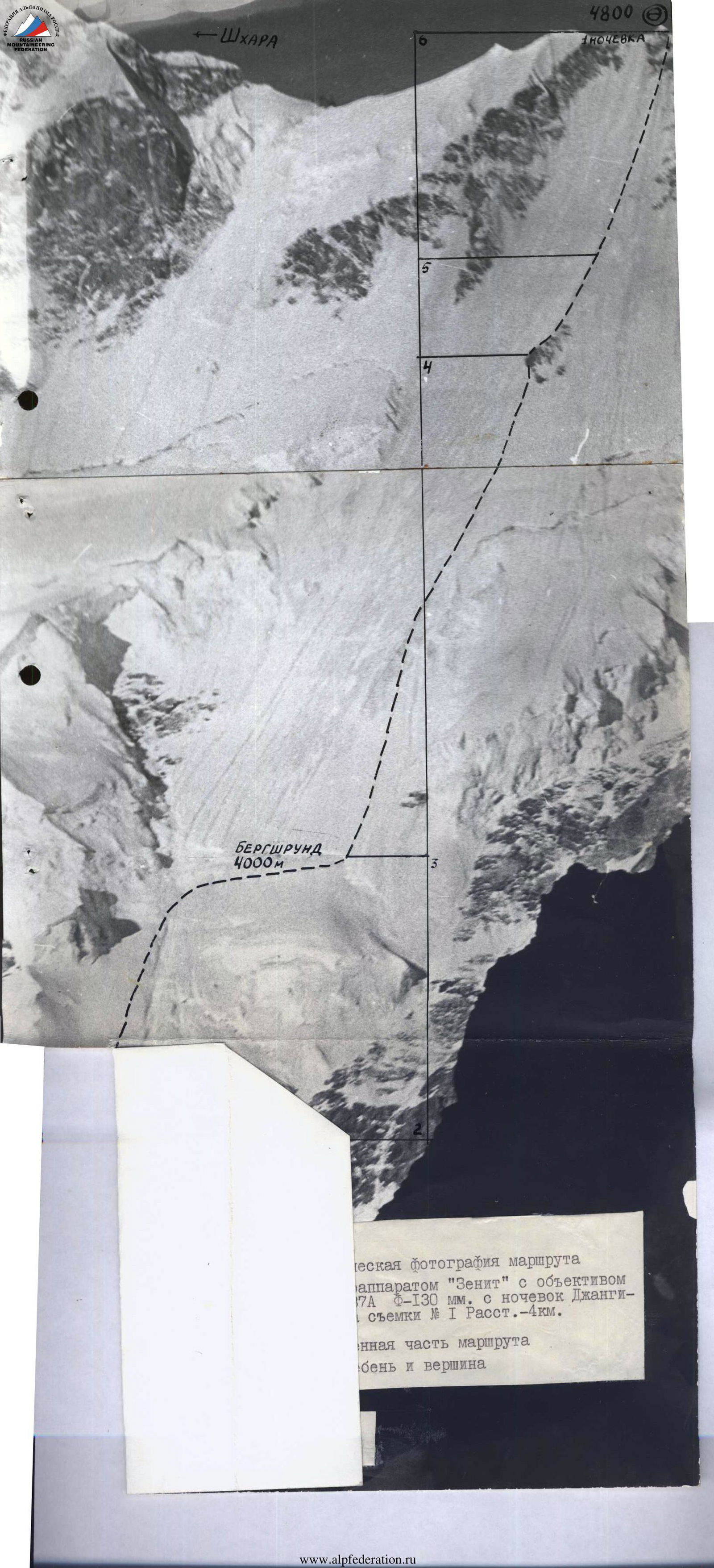
Taken with a "Zenit" camera, "Helios-44M" lens, F - 58 mm. Taken on August 5, 1986, from "Jangi-kosh" overnight location. Distance - 4 km. Point #1.
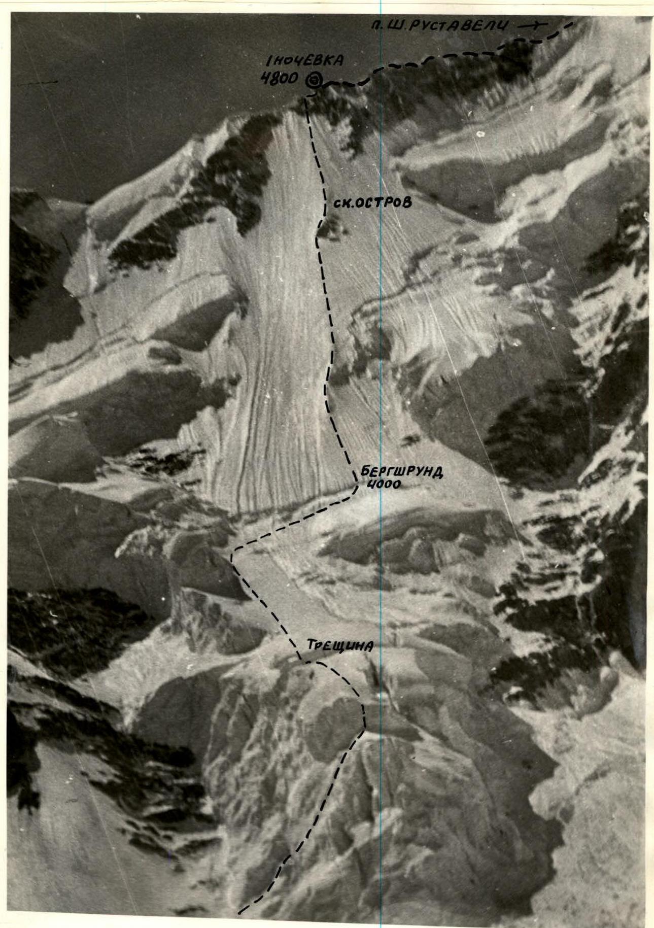
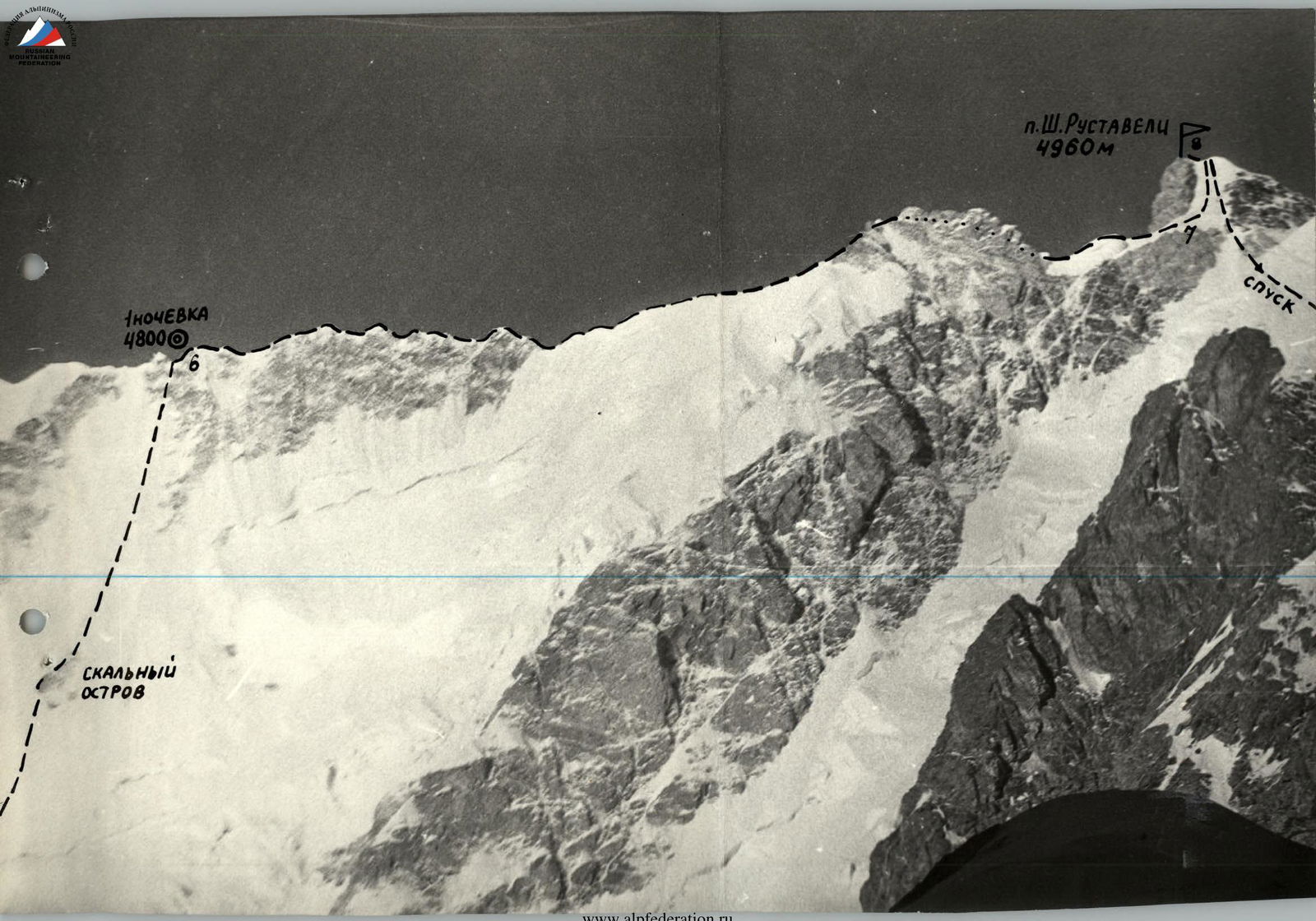
Photo of the summit from the left
Legend: – Taken with a "Vilia" camera, F - 40 mm. – from Bezengi glacier (4) – Overnight locations
Profile. 2 km. Point #2. The best profile can be taken from the summit of Shkhara or from the route to Shkhara peak.
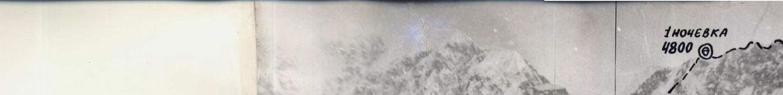
Photo of the route profile from the right. Taken during descent via a 4-6 category route from the summit of Jangitau. Poor weather - fog, snow. "Vilia" camera, F - 4 cm. Distance - 1 km. Point #3. The route to peak Shota Rustaveli via the north face was ascended by the team as part of the RSFSR championship, consisting of 4 people.
Team members: – Team member 1 – Team member 2 – Team member 3 – Team member 4
Tactical plan (attached) was made on August 5, 1986, and was followed.
The discrepancy in the time of departure from the camp under the route, being 2 hours instead of 1, is explained by: – On the day before departing for the route, it was established that icefalls occur until 2:00 am. – Previous teams departed for the route under moonlight.
Departing at 2:00 from the camp under the route (movement on the route began at 2:30), the team walked in the dark for a shorter time. The team's tactical actions were flexibly adjusted as the terrain changed.
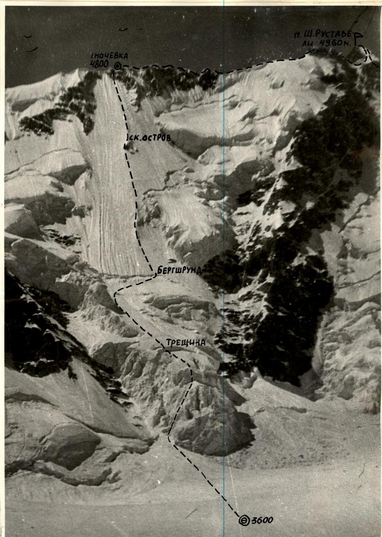
The lower part of the icefall was ascended using ice axes and by hanging belays.
While crossing a crevasse, the team encountered a complication on the route, contrary to the description of this section by the first ascenders. As a result of glacier movement, a crevasse formed, which was not mentioned in the reports or by subsequent climbers.
The section from the crevasse to the bergschrund - simultaneous movement by independent rope teams with belay through ice axes.
From the bergschrund to the rocky outcrop, the team moved as independent pairs on a doubled rope with piton belay. The doubled rope was a pre-planned tactical decision. The second climber moves to the first along the belay rope with top-rope belay, then proceeds as the lead on the double rope and sets up a belay station.
Advantages of this movement:
- There is a good midpoint for rest, set up by the first climber in the rope team.
- Reliability of belay - as a double rope is used.
From the rocky outcrop to the ridge, they ascended by changing the lead along the belay rope.
Rope team composition: Opoitsev-Kalagin, Guryev-Kalyuzhny. Each team member had a hammer and ice axes, or an ice axe and ice hammer.
The ice screws with handles proved very useful for organizing self-belay.
The use of screws for ice screws saved a lot of time - each team member had one.
All team members took turns and worked as the lead throughout the route.
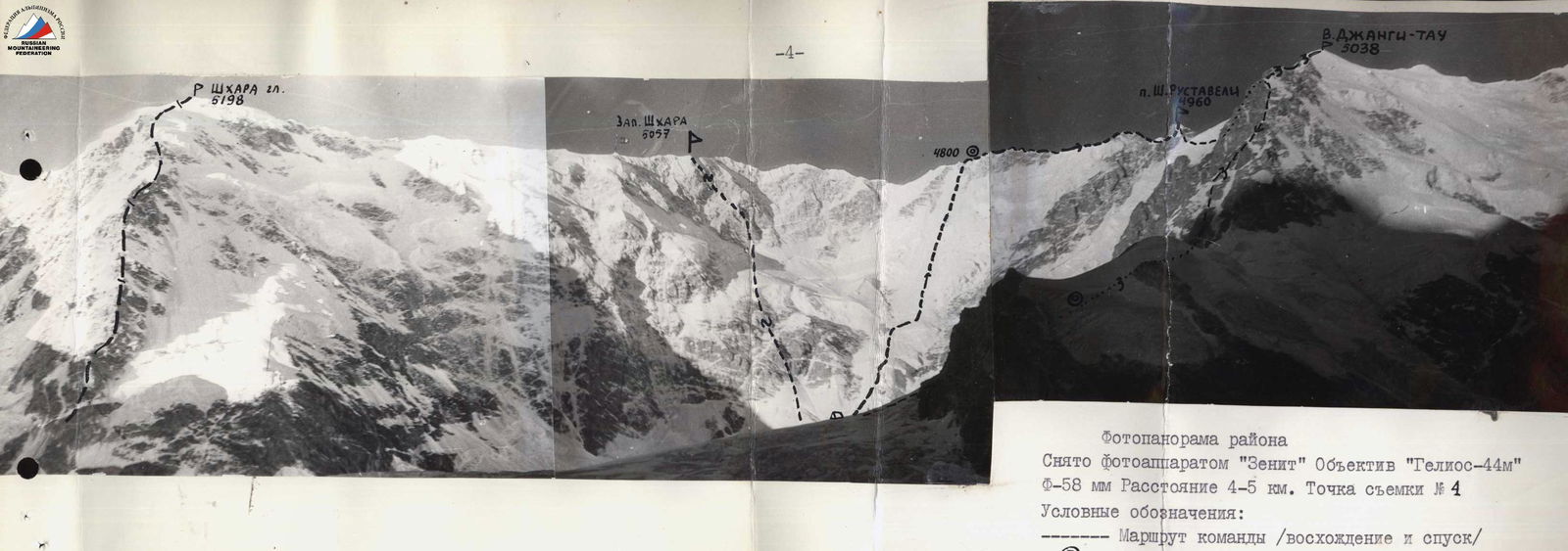
Photopanorama of the area
Taken with: – "Zenit" camera – "Helios-44M" lens – Focal length: 58 mm – Distance: 4-5 km – Shooting point: #4
Legend: – Team's route (ascent and descent) – Overnight locations
Routes to Shkhara peak: – Tomashek 5B category – 3. 4B category Jangitau – Blankovsky 5B category
Communication with observers was carried out via "Vitalka" radio. The route was well observed from the overnight locations near "Jangi-kosh" hut, so all the team's actions were visible. There were no falls or injuries during the ascent. Environmental protection measures were observed during and after the ascent - all used pitons were removed, flammable materials were burned at bivouacs, tin cans were crushed and buried in deep crevasses.
After the ascent, the overnight locations at "Jangi-kosh" hut were cleaned of trash.
The delay on the route while ascending the ice wall is primarily explained by the state of the route. 1986 was a very low-snow year - there was practically only ice on the route, so belay was mostly piton belay.
If it took about 1 minute to screw in a piton with belay organization and removing ice from the piton, then for 2/3 of the route this amounts to: 250 × 2/3 ≈ 166 pitons or 2 hours 40 minutes: 4 participants - each lost half an hour screwing in pitons.
For comparison - A. V. Laletin's team of 8 people hammered approximately the same number of pitons on the route. Per participant: – Time loss is half.
It was also affected by the fact that moving on ice is significantly more difficult, and team members had to rest more often than the first ascenders. Route diagram in YUAA symbols.
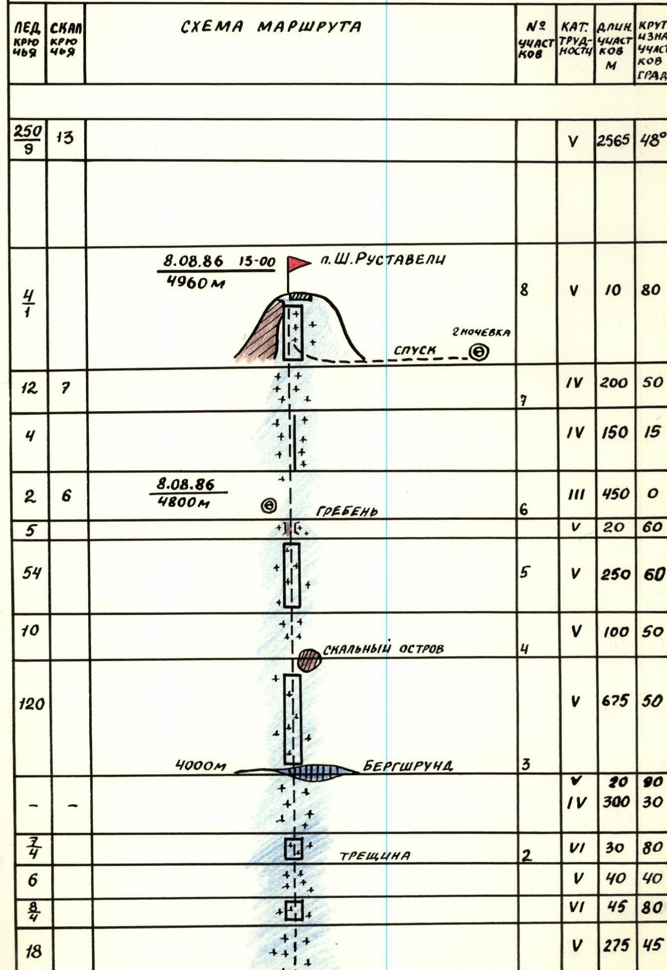
Route description by sections
R0-R1. Approach to the route - a gentle snow-ice slope.
R1-R2. Section to the large crevasse. Ascended in the dark. Steep, almost vertical walls. Exit from the crevasse via a snow-ice bridge and then along an 85-90° slope of the crevasse. Complication on the route. The crevasse likely appeared in 1986.
R2-R3. Section to the bergschrund. Simultaneous movement with belay through ice axes.
R3-R4. The longest section to the rocky outcrop. Ice, practically no snow. Piton belay, independent movement by rope teams.
R4-R5. Section from the rocky outcrop. Snow-ice ridge - 2 ropes.
R5-R6. Exit to the ridge - the steepest part of the route. Last rope - movement along icy and snowy rocks.
R6-R7. Rocky-ice ridge.
R7-R8. Exit to the summit of peak Rustaveli. 200-meter ice slope.