Passport
of the ascent (first ascent) to Salynan peak via the North face.
I. Climbing category: technically — challenging.
-
Climbing area: Caucasus, Chegem valley, Kargashil ridge.
-
Ascent route: Salynan peak (4350 m) via the North face.
-
Ascent description: – total altitude gain of the route 950 m, including: – lower ice ascent of the face 75 m, – middle ascent (Central bastion) 120 m, – upper ascent of the face 180 m, – pre-summit wall 40 m; – average steepness (degrees/meter) of the route 60–65°; – length of very difficult sections (steepness 60° and more) about 600 m; – total route length 1220 m.
-
Pitons used: rock — 93, ice — 33.
Ladders were used 17 times.
-
Time taken: approach 7 hours, on the route 10+16+13.5+3 hours, descent 7 hours.
-
Number of bivouacs and their characteristics: 1 — base camp under the face, on snow, normal; 2 — (descent after processing the start of the route); 3 — semi-hanging bivouac for two on the Central bastion wall, on ledges; 4 — semi-sitting bivouac under the pre-summit wall, artificial shelf.
-
Team name: team of a/l "Bezengi", DSO "Trud".
-
Captain's and team members' names, qualifications: Team Captain Daruga V.K. CMS Team members – Efremov N.L. CMS – Korkin I.V. Master of Sports of the USSR – Porokhov E.N. CMS
-
Team coach: Honored Coach of the RSFSR Kudinov I.B.
-
Dates of the ascent: – departure from a/l 12 July 1974 – approach to the face 13 July 1974 – start on the route 14 July 1974 – summit and return to a/l 17 July 1974
Team coach:
 Team captain:
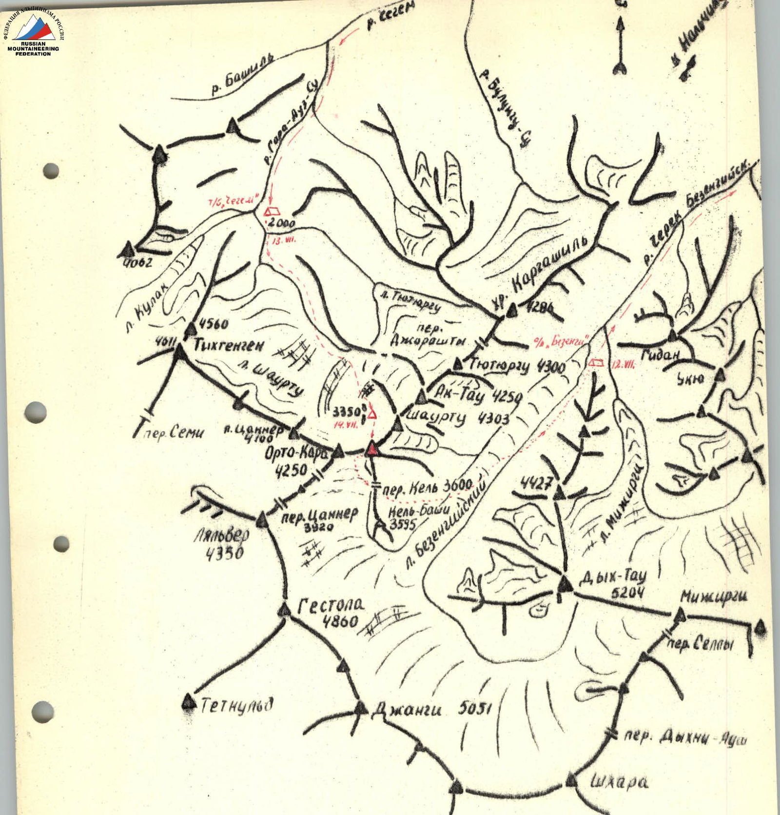
Map-scheme of the area
Salynan peak (4350 m), Kargashil ridge.
First photograph, first plan of the route. View from the moraine of Kulak glacier, July 1960.

North face of Salynan from Chegem valley (from Narzan), August 1968, 12:00.
Route plan 1972.

North face of Salynan. Reconnaissance July 1973, 19:00, from the moraine of Shaurtu glacier. Route plan and path taken, 1974.
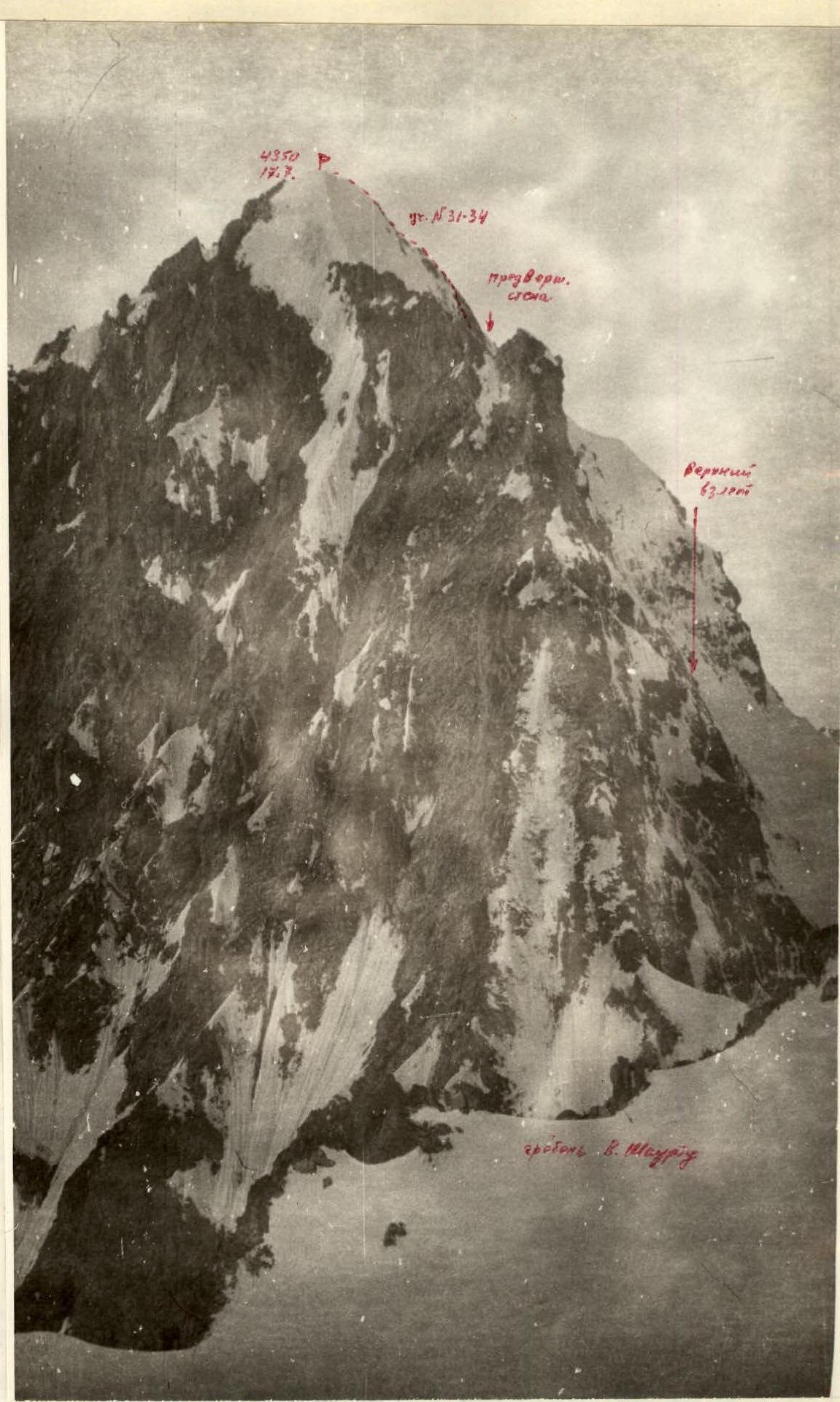
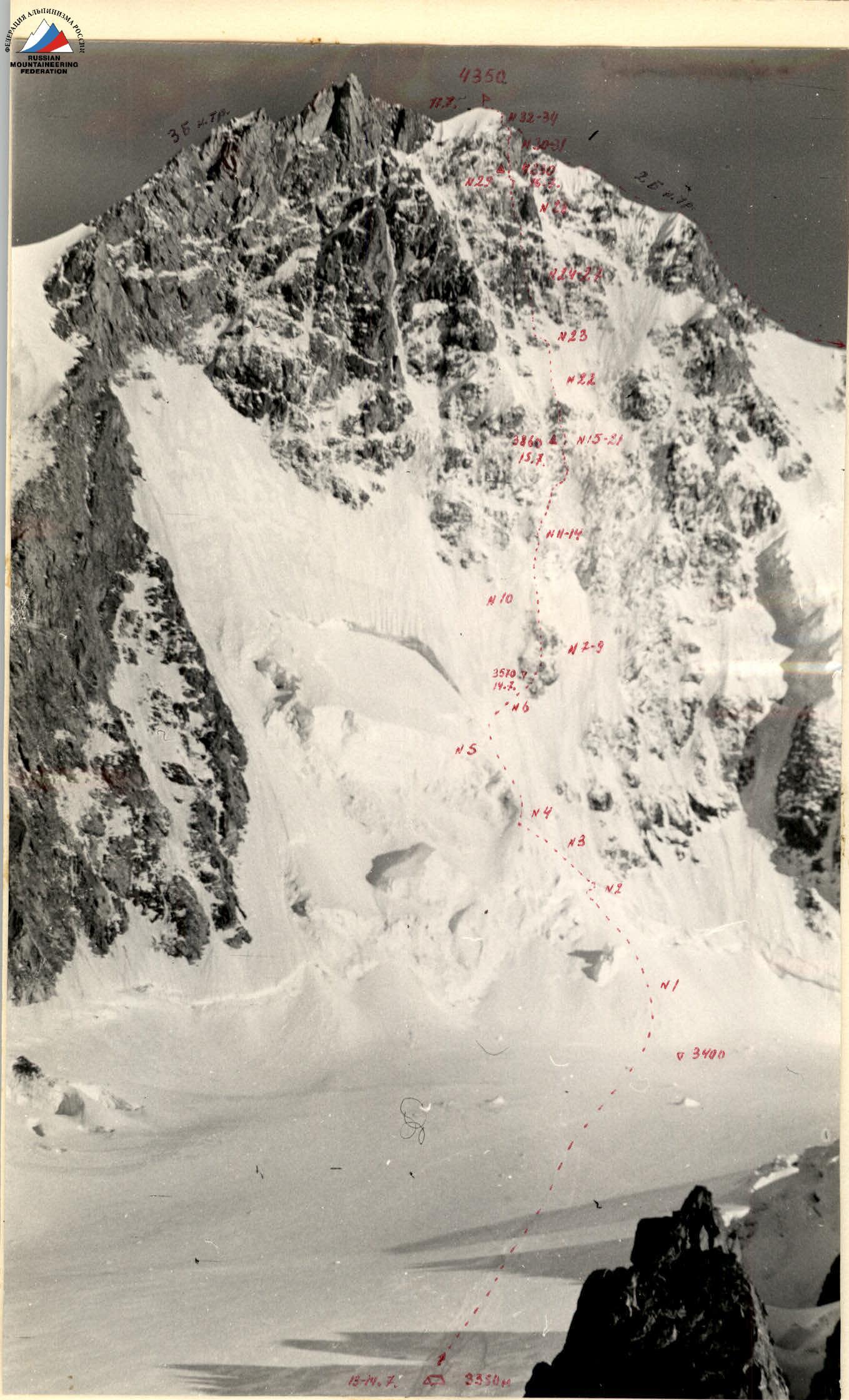
North face of Salynan, profile.
Reconnaissance 1973, July, 8:00, Western ridge of Shaurtu.

Profile of the North face of Salynan. Reconnaissance 4 July 1974, 16:00, Eastern ridge of Orto-Kara.
Geographical location, area characteristics, history of exploration.
Salynan-Bashi peak is located in the Kargashil ridge, which branches off from the Main Caucasian ridge in the area of Orto-Kara peak between Gestola and Tikhtengen, more precisely — from the Tsanner pass, where the classic traverse of the famous Bezengi wall usually begins.
The ridge starts from the pass with Orto-Kara peak and goes in a north-easterly direction with a chain of peaks over 4000 m, dividing two valleys: – Bezengi valley – Chegem valley
The second peak of the ridge is Salynan peak 4350 m.
Despite being close to the well-known sport climbing area of Bezengi, this ridge remained outside the interests of climbers for a long time, especially since the slopes of its peaks from the Bezengi valley side are not very interesting for experienced climbers in terms of relief and technical difficulty. Recently, starting from the late 1960s, several routes of 2nd and 3rd cat. diff. have been laid here for training purposes along the ridges to Orto-Kara, Salynan, Shaurtu, Ak-Tau, and Jorashy-Kurshagan peaks.
At the same time, sports teams of a/l "Bezengi" continued to focus on the routes of the famous Bezengi wall and the Lateral ridge. New paths were laid on: – Krumkol (4th place in the USSR) – Katyn (3rd place) – Mizhirgi (6th place) – and others.
The need to search for new objects in new areas had long been ripe. In the early 1970s, the Dumala area was developed, and in 1967, the first ascent of the complex North face of Nuam-Kuam (Dykh-Su valley) was made. Teams of a/l "Bezengi" reached Tetnuld and Tikhtengen. Among other possible objects, the North face of Salynan, rising 1000 meters from the Chegem valley, was of particular interest.
The beginning of the exploration of the Chegem valley by climbers dates back to the pre-war years when a/l "Lokomotiv Yuga" was created. However, serious sports ascents began only in the 1950s. In 1957, a remarkable first ascent was made on the north-eastern face of Tikhtengen by a team of Spartakovites led by L. Filimonov. However, after the liquidation of a/l "Chegem" in 1961, the development of the area almost stopped, and it was even thought that there were no serious objects for sports teams here, except for Tikhtengen, although in the 1960s V.M. Abalakov and Ya.G. Arkin pointed to the North face of Salynan as a worthy object for future sport climbing.
Upon closer examination of this area, about a dozen objects can be counted on which routes of 4B and 5B cat. diff. can be laid. Among them: – Tikhtengen – Kulak-Tau – Bashil-Tau – Tsanner pass – Ak-Tau
One such route of 5B cat. diff. was climbed in 1974 by a team from Kabardino-Balkaria.
Characteristics of the object, stages of study, reconnaissance.
The most impressive and serious object among the still unclimbed ones in this area was, of course, the North face of Salynan peak. The peak got its name precisely because of the view of the face from the valley — "falling mountain". It looks like this from the wide, forested fork of the valley under the slopes of Tikhtengen — like a giant hanging shell, shining in the side rays of the sun.
Our first acquaintance with it took place back in 1960, from the Bashil valley. We began to study the North face seriously as an object for future sport climbing in 1968–1969. At that time, we were very concerned about the fact that the face was glaciated despite its steepness. In 1972, the North face was included in the team's application, but serious discussion showed that we were not ready for the assault — the safety of the route was not sufficiently understood.
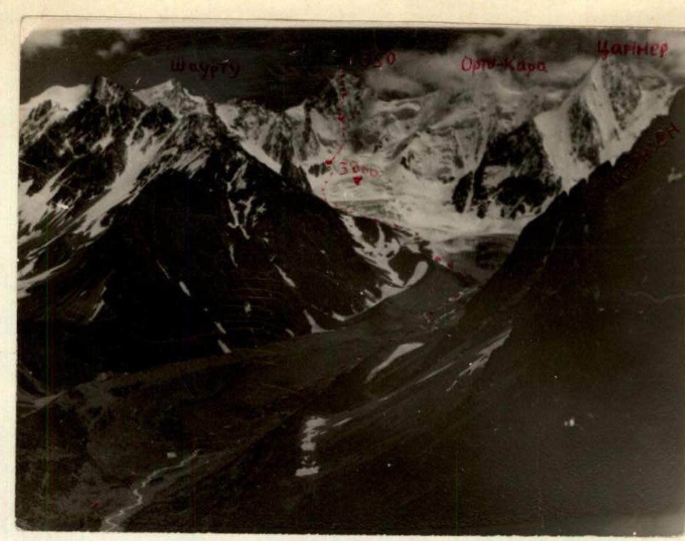
In 1973, it was decided: – team captain V. Daruga with a group of разрядники to go to the Chegem valley under the face for a general inspection and photography; – team members E. Porokhov and N. Efremov to climb the ridges of Salynan and Shaurtu during training ascents to study the profile and top of the face. Reconnaissance in July–August 1973 allowed the coach and team to make a final decision on the assault in the summer of 1974.
What did the reconnaissance show? Weather conditions for climbing in this area are not much different from those in Bezengi, the climate is more humid, and strong winds are characteristic — this is a zone of mixing cold air masses from Bezengi and warm air from Svaneti ("rotten corner").
The approach from the tourist base, which can be reached by car, is associated with a significant altitude gain: first along scree and moraines, then along a rather complex Shaurtu glacier (3000–3200 m). To approach the face, you need to climb from the glacier to a snow-ice plateau, which rises 100–150 m above it and is supported by huge rock nunataks.
The face itself has the shape of a concave shell, with an almost continuous steepness from 45° to 90°. Due to its concavity and purely northern orientation, the face is almost not illuminated by the sun (in the morning due to the neighboring Shaurtu peak), is constantly blown by cold winds. Heavy precipitation immediately falls down, and the melting of ice cover on the slopes and snow on the rocks is so slow and short-lived during the day that rime ice quickly forms, covering not only the slopes but also steeper rock walls. In fact, the entire 120-meter middle ascent of the face with a steepness of 70–80° is covered with a rime ice crust 5 to 25 cm thick. The lower part of the face is covered with rime glaciation up to 2 m thick at a steepness of 60°.
The character of the rock relief is strongly dissected, blocky, and slab-like ascents, but the wall's looseness is low due to the cementing effect of rime ice. Hence, the understanding of the objective relative safety of the route: snow-ice falls are unlikely, and rockfall danger is low due to the cementing effect of rime ice, shading of the face, and rapid discharge of precipitation. Accordingly, during heavy snowfall, the danger of the route should increase immeasurably. In principle, it is possible to leave the face at any place along the slopes under the ascents to the left and right by traversing (albeit very complex) about 150 m to the edges, with an exit to simpler rocks to the saddle and ridge towards Shaurtu and the pillow and ridge towards Orto-Kara. Thus, a simpler and faster approach of a rescue team to the group on the route is possible in case of need, for example, from a/l "Bezengi" through the Kel pass and the Salynan-Orto-Kara saddle.
Preparation, plans, and their adjustment.
Based on the above, a plan for preparation and carrying out the ascent was drawn up. It was assumed that the storming group would consist of 4 people (for efficiency and due to the difficulty of bivouacs). The route would follow the most safe natural direct path: island — ridge — wall — ridge — wall — ridge — summit. The following options for changing the plan on the spot were provided: if the exit to the first night's bivouac under the cover of the middle ascent proved impossible due to the complexity of passing the lower ascent, processing of the lower wall would be carried out with a descent to the base camp; since the passage of the lower part of the Central bastion seemed potentially dangerous in the second half of the day, a backup option was planned through the Left bastion. It was assumed that the key point in all respects would be the exit under the middle ascent and its passage. The ascent was planned for mid-July, during a period of stable good weather and minimal precipitation (usually, based on many years of experience, this is July 10–20). In case of deterioration or instability of the weather, the exit to the route was canceled.
To prepare the team (training) in the mountains and familiarize themselves with the actual state of the route before the exit, the following plan was drawn up: – Reconnaissance exit to Orto-Kara (2A cat. diff.) — July 2–4, 1974 – Training ascent of a similar nature on the North face of Ullu-Auz (5A cat. diff.) — July 6–8, 1974
The exit to the main ascent was planned for July 11–15, 1974. The team composition was announced as follows: team captain Daruga V., team members Efremov N., Ponomarev V., Porokhov E. In this composition, the team was tested in 1973 on the first ascent of the North face of Pioneer peak (5B cat. diff.) and took 3rd place in the g. Moscow championship.
Most of the plan's points were successfully implemented, and some deviations had an objective character. So, despite all efforts, Ponomarev V. did not get released from work and was replaced by Korkin I., a Leningrader well known to us from ascents in Bezengi and the Pamir. The training plan was fully implemented. The route on the North face of Salynan was climbed in the planned timeframe, in good weather conditions. No unexpected events unforeseen by us occurred during the assault. On the first day under the face, the work plan was unambiguously clarified: processing and movement through the Central bastion. The team was prepared for the possible lack of convenient bivouac sites. In accordance with the tactical plan, the group climbed the route at a fast pace, slopes were passed in the morning hours, in the second half of the day the group worked and bivouacked under the cover of wall-ascents.
The team was provided with a observation group and reliable two-way radio communication with observers and the camp.
Below is a description of the route and the order of the team's work on the ascent. The following documents are also presented: – Safety measures plan – Observation log – Equipment and food lists – Act for non-standard equipment – Route sheets – Note – Photographs and diagrams – Characteristics table – Debriefing protocol – Judge's conclusion
Some points of this report are also reflected in the debriefing protocol. It should be noted that some quantitative data presented during the debriefing were, naturally, preliminary (the debriefing was conducted the day after the team arrived at a/l). The report and table of main characteristics provide clarified data.
Description of the ascent of the team of a/l "Bezengi"
to Salynan peak via the North face.
July 12, 1974. In the morning, the team was fully ready, accompanied by the Authorized representative of the Sports Committee, member of the Judges' Collegium Z.P.S., and the head of KSP Babinin A.V., and left the camp by car. The weather was cloudy, with occasional rain. The calculation was that by the time they reached the route, the weather would stabilize for several days (taking into account the local weather forecast).
The descent to Nalchik took 4 hours. From Nalchik to Chegem-2 settlement and further along the highway along the Chegem river, then along a dirt road through the Chegem valley to the confluence of the Bashil-Auz-Su and Gara-Auz-Su rivers. Along the Gara-Auz-Su river to the "Chegem" tourist base. The total ascent by car took 5 hours. They arrived at the tourist base at 14:00 and stopped to rest and spend the night. In the second half of the day, there was heavy rain, but the cloud cover was low. According to the consultation received here, there is no precipitation in the highlands — so the route is clean. It was decided to head under the face tomorrow.
July 13, 1974. Weather: clear, clear sky (as if by order!), wind. Departure at 6:00. From the tourist base along the "narzan" trail towards the cut of the northwestern ridge of Tikhtengen peak to the bridge over the stream fed by the Shaurtu glacier — 30 minutes walk. From the bridge, the North face of Salynan is visible. The releasing officer and the head of KSP, armed with powerful optics: – carefully examined the face, – compared photographs with the original, – meticulously clarified the assault plan, – conferred — and finally gave the go-ahead.
Their recommendation was to prefer the option via the Central bastion.
Without crossing the bridge, along the left bank along the water's edge (there is no trail), ascent up the valley to the terminal moraine on the left of the Shaurtu glacier tongue — 1 hour. Then to the left under the steep slopes of the high lateral moraine, along the stones of the terminal moraine, bypassing the Shaurtu glacier tongue. Through quite bumpy "pockets" under the walls of the lateral moraine — 1 hour, up to the turn of the glacier and moraine to the left. Here we exit the glacier turn at the level of the beginning of the first step of the glacier fall. The altitude gain from the tourist base is about 0.5 km. Along the left side of the glacier, ascent up to the left parallel to the Kargashil ridge, crevasses are bypassed in a zigzag towards the lateral moraine, the steepness of the glacier fields is 25–30°, 1 hour walk. We reach the gentle part of the glacier and to the left to the lateral moraine, to the edge of the second step of the glacier fall — 30 minutes walk. The slopes are bypassed on the left, along snow "pockets" and ascents (steepness of the ascents is 20–30°). We exit up to the right above the glacier fall in the direction of Shaurtu peak — 1 hour. Further movement goes across the glacier (crevasses!) in the direction of a separate group of rocky peaks-nunataks rising in the middle of the glacier and supporting the snow-ice plateau under the North face of Salynan. To the rocks is 1 hour walk. Here to the left under the glacier fall from the plateau, then along a 200-meter snow ascent between the rock and the glacier fall (steepness from 30 to 40°, insurance through ice axes!) we exit to the plateau behind the Big rock — 1 hour walk. Further to the depression under the Small rocks — here is the group's and observers' base camp. The place is safe but lacks water and is strongly blown by the wind. The wind is cold, gusty, and blows snow from the plateau.
For 7 hours of ascent with a load from the tourist base, the altitude gain was more than 1100 m. However, there is time to rest. The weather is clearly stable. We spend the second half of the day observing the face and examining the route through binoculars. Conclusions: there is no fresh snow on the face, open ice and significant glaciation up to the upper rock ascent; from the reflection, it can be assumed that there is rime ice on the Central bastion, but the exit to the bastion is safe. The lower ascent of the face is an ice wall. If we go straight to the route with backpacks, we may not reach the Central bastion, and then the problem of bivouac will arise in the middle of a steep ice slope under the threat of rockfall or icefall from the upper ascents. It was decided to process the route to the island and descend to spend the night in the base camp, so that tomorrow we can quickly exit to the Central bastion wall.
July 14, 1974. Clear sky. Very cold, strong wind. The team's departure for route processing at 7:00, with a load: pitons, ropes, warm clothes, food. Route: – along the snow plateau, ascent under the face (30–40 minutes, slope steepness 10–20°) in the direction of the bergschrund arc above the snow cone with a separately protruding ice block; – to the right of the block along the snow cone, two ropes (2 × 40 m) straight up to the bergschrund outcrop (steepness changes from 30 to 45°, dense snow); – in a small pocket under the bergschrund outcrop, it is possible to gather and put on crampons, as further on is an ice wall.
To the right of the pocket (3 m, end of R1 — see table, photo, and diagram), at the point of approach to the oblique ice crevice, the bergschrund is passed along a 3-meter ice wall of the outcrop (ice piton, ladder), overhanging in the upper part. From under the overhang through the icicle curtain to the left 1 m and exit to the ice wall of the lower ascent of the North face into a previously dug out hollow under the beginning of the oblique ice crevice (ice piton, R2).
Further, there is an oblique (at an angle of ~50° to the horizontal) traverse up to the left of the ice ascent along the oblique ice crevice (along the lower edge with the cutting of steps and handholds) — R3, steepness about 60°, 60 m, 3 ice pitons for insurance. The ice is porous, loose, with a rime crust on top! The traverse leads under the ice wall of the right edge of the large ice outcrop (R4, steepness 65–70°, 2 ice pitons), along which 20 m up with the cutting of supports and handholds to a slope of 60–50° above the right angle of the roof of the large outcrop. Here begins a vertical ice crevice, and it is possible to cut out a niche for the future reception of backpacks. Further up along this crevice (R5, ice piton, cutting, and front teeth) ascent 40 m to a place to the right of the junction of the small outcrop and the upper arcuate ice crevice of the slope. The steepness here decreases to 45°, to the right and above is a pure ice slope, resting against the walls of the middle ascent of the North face. Along the slope, traverse (R6) to the right and up (direction 45°) to the bottom of the rocky island (2 ice pitons, 40 m with cutting of steps).
The island (R7–R9) begins from the slope with an 8-meter sheer wall of dissected structure. Traversing under the wall along the junction of rocks and ice and further up to the right (2 rock pitons, live rocks!) to the rib, we ascend along the sheer rib of the wall 5 m (rock piton, future pulling of backpacks!) onto 60°-steepness slabs with ice on the island slope. Here the processing of the route is finished. The time is around 16:00. 180 m of belays are hung. There is nowhere to bivouac on the island, and it is risky; we won't reach the Central bastion today — we made sure of it! The descent down took 1 hour.
July 15, 1974. Clear, cold. Strong, gusty wind. Departure from the base camp at 5:00. Along the belays, we quickly reach the island. The 80-meter belay rope is thrown down to the observers.
Along the slabs (R8) up 10 m (rock piton, there are live rocks and rime ice!). This section is made of slabs like a tile roof, but crampons and solid rime ice help. Further, two rock walls (sheer steps, total 15 m, 2 rock pitons). Gradually, the steepness decreases on the next 20 meters to 50°, to the second outcrop-wall of the island, smoothed rocks with rime ice in the form of a ridge lead (rock piton). The wall is about 70° steepness, climbed straight on (wet rocks, but strong; rock piton) 15 m and then with a 5-meter arc to the right and up, we exit (rock piton) to a rock-ice forehead (5 m, ice piton), turning into an ice ridge, going up towards the Central bastion.
The ice ridge (R10, 45–50°) is not very pronounced, as it seems from below; the ice on top is loose, sagging. For reliable piton placement, it is necessary to cut out a deep hollow. Along the ridge on front teeth (piton and ice axe pick in hands), we pass 80 m, having driven (or rather screwed in) 4 ice pitons for insurance. At the end, the ridge disappears, merging with the slope-scat, a step rising to the middle ascent of the North face. The steepness increases to 55°, the rime crust on ice and rocks is thicker and stronger. 20 m and two ice pitons to a black rock wall, into it a rock piton, and along the right edge, an obstacle-avoidance move (2 m, 70°). Again, ice on the slope with rock outcrops, 10 m from island to island with cutting of steps and handholds (2 ice pitons and one rock piton). The rocks are covered with rime ice a few cm thick; they need to be chipped and cleared. We exit under a нависающий грязно-рыжий козырёк выпирающей скалы, 10 m obstacle-avoidance move to the edge of the rock (3 rock pitons) to the right with an arc, steepness about 65°. To the flow of ice crumbs coming from the first, rain of small ice grains coming from the entire face through the bastions of the middle ascent is added. We exit above the overhang (3 m, rock piton) and ascend to the ice ascent like a wide shaft with outcrops of ice-covered rocks, ice is rime, strong. Holding to the left of the glaciated steps descending from under the ice "mirror", 20 m with cutting of steps and handholds (2 ice pitons, rock piton) to a flattening and onto a rock-ice slope with a steepness of 50–55°. Along it 30 m (2 rock pitons, insurance, movement on ice) in the direction of the base of the Central bastion. The slope turns into a pure ice slope-scat, along it on front teeth (2 ice pitons) 20 m to the base of the Central bastion (end of R14). Thanks to yesterday's processing and good rest, the forces are preserved, the time is 12:30. It starts to warm up, the temperature rises to clearly positive.
The wall of the Central bastion (R15–R20) rises sheer up. To the right is a slab 70°, covered with a thick layer of rime ice, to the left overhangs a ledge 10 m high. We attach a control tur to a crack and a note. Everyone hangs on pitons close to the rock to be in the safety zone from being hit from above. The first (without a backpack) goes up and slightly to the left: small footholds, 3 rock pitons, ladder. Climbing to the ledge, chipping rime ice from footholds and cracks.
From the ledge up and to the left along an iced-over sheer with a crack 5 m (2 rock pitons) we enter the inner vertical angle, filled with thick flows of rime ice. From the angle, a traverse up and to the right under the нависающей стенкой, cutting hand and footholds in the ice cover 10–15 cm thick, 5 m of complex climbing (rock piton, ice piton, ladder) lead beyond the edge of the angle to the iced-over main wall with a steepness of 70° (R16). Movement up with ice chipping is dangerous and labor-intensive; the first 20 m are passed in 2 hours; there is nowhere to receive backpacks! We decide to traverse the wall to the right edge, where there is less ice.
Traverse to the right 20 m (up at an angle of 30°) with cutting holes for hands and feet in the wall's ice armor (4 rock pitons, ice piton), movement from ledge to ledge. We exit to a yellow rock wall, overhanging from below; under the overhang is a ledge and a crack; here we can receive the second. The second prepares a rope directly to the lower ones under the wall for pulling up backpacks. The first passes traverse 5 m under the overhang (2 rock pitons-wedges), then 3 m up and to the right from the ledge of the gray-green wall (smooth, 70°, piton-wedge) to the edge of the rime ice flow (next to the ice "mirror", a huge iced-over depression between the Central and Right bastions). Along the edge 1 m (ice piton) up and along the sheer gray wall-slab with a crack 8 m (2 rock pitons-wedges and 2 ladders) up to the rib of the bastion with a small ledge. This is on the border of the wall and ice "mirror"; further, ice again overlaps the wall. Here, a system of pitons is driven in for pulling up and hanging backpacks (R17). Pulling up occurs from the lower ones with a pendulum along the wall: first, the second organizes a pendulum, then the first pulls up, as directly to the lower ones is 50 m from the ledge. Further, the order of movement is as follows: the first goes further, the second to the first's place, the third to the second's place, and so on.
From the ledge 4 m along the wet inner angle (water) of the wall's rib (70°, rock piton, ladder) under the нависающий козырёк, the upper edge of the yellow wall (R18). Traverse (deflected) along the crack 3 m to a tooth on the left, where the overhang is less, with the help of 2 rock pitons and 2 ladders. Obstacle avoidance of the tooth from below along the sheer is very complex, small footholds, deflected (rock piton, ladder). Then 2 m up on the left side of the tooth — climbing along a not very pronounced iced-over inner angle (rock piton, ladder) onto the tooth. Further, the wall is 70°, slab-like rocks with cracks — 10 m slightly to the left and up (iced-over rocks, 2 rock pitons) to two rock ledges. Here is the second stage of receiving backpacks: backpacks are placed on pitons; two people can work at once (R19). Further along black slabs-walls, dissected and with ice, steepness 60°, to the right and up 5 m (rock piton), then along the walls-steps 15 m with obstacle avoidance along corners and ice ledges (2 rock pitons) in the direction of a large step-sheer, to the right of which a 5-meter inner angle is visible, leading from right to left onto a large ledge in the middle of the sheer (rock piton). At the beginning of this angle, there is also a ledge to the left under a cornice.
The time is 20:00; by the time the second double reaches here, it will be 21:00. Reconnaissance on the rope further: the same, 60–70° steepness, no ledges.
We set up a semi-hanging bivouac for two on ledges: a woven harness made of reepschnur and suspension from a chest harness, legs in a backpack, covered with a bag and polyethylene film. At 21:30, in the dark, the bivouac is ready. Above us is a sheer — so it's safe, which is the most important thing now! At night, it's cold, frost, and a gusty, piercing wind. All night we move, warm our legs, and sleep in turns every hour.
July 16, 1974. The weather is clear, very cold, wind. Gathering from the bivouac is a whole problem: everything must be carefully untangled and packed into backpacks. We depart at 7:30.
From the end of the inner angle to the right along the sheer and 15 m along the slabs with ice (60°, 2 rock pitons) under the last ascent-sheer of the Central bastion (R20). Here 10 m under the wall-slab along the inner angle (rock piton) and 5 m traverse to the right under the sheer (rock piton). We exit into a vertical crevice 5 m (rock piton). Along it, an exit to the outer left angle of the wall, along the sheer 2 m (rock piton, ladder), and further along a steep slab 5 m (rock piton) onto a smoothed, iced-over rocky forehead 20 m, which ends the Central bastion (flattening to 50°, 3 rock pitons). Immediately begins a not very pronounced ice ridge (R22) of the middle slope of the North face.
The ice ridge from 45 to 50°, 80 m, ice on top is loose, eaten away, goes on front teeth and with a piton and ice axe in hands (4 ice pitons for insurance). The ridge leads to a rocky, discontinuous threshold made of walls 3–4 m high. Along the left wall of the ice gorge (2 rock pitons), a traverse to the left and up to exit above the threshold and further to the left. Up goes an ice slope (R23) with a steepness of about 50°, resting against the upper rock ascent of the North face. Very steep, and crampons no longer hold; they have become dull from the very bottom! We go in a traverse-zigzag along a chain of rock outcrops 20 m to the left and up (rock and ice pitons) and then along the walls-steps in the ice up and to the right 40 m to the wall to the right of the deep crack cutting through the upper ascent (2 rock and 2 ice pitons). The time is 13:00.
The exit to the upper ascent (R24–R28) along the wall 5 m (70°, rock piton) and onto a shelf on the right edge of the wall. From here along this edge (goes in steps 40 m, rocks are dissected with an average steepness of 70°, 4 rock pitons) to a destroyed crack (live rocks!) in a 10-meter wall. Along the crack (rock piton), an exit under a toothy sheer wall, along it 2 m (piton, ladder) up and to the left behind the corner 3 m (rock piton) onto an inclined destroyed 2-meter shelf on the left side of a large iced-over inner angle (R25, water and rocks!). From this shelf without a backpack, a traverse along the edge of the angle in depth 5 m along the edge of ice and 5 m along a sheer gray wall with a narrow shelf (rock piton). Further, the wall is smooth, and it is necessary to go up along the sheer 5 m (rock piton, ladder), using a crack and a ledge at the top (deflected!). Above the wall is an inner angle with a steepness of 70°, along it 10 m (2 rock pitons, 2 ladders, smooth rocks) and slightly to the right under a completely smooth gray навес, which is bypassed to the right along a shelf and crevices with a 10-meter arc (rock piton). Further to the left along steep slabs (60–65°, 2 rock pitons) onto a shelf above the gray навесом (backpacks are pulled up here), and from it along rocks of medium difficulty (45°, destroyed!) up 5 m — an exit to a shoulder-step in the middle of the upper ascent (R27).
Along this shoulder 10 m (rocks with ice, 35°, ledges — the first simple section!) under the yellow wall of the upper part of the ascent (rock piton). This part of the ascent is very dissected,