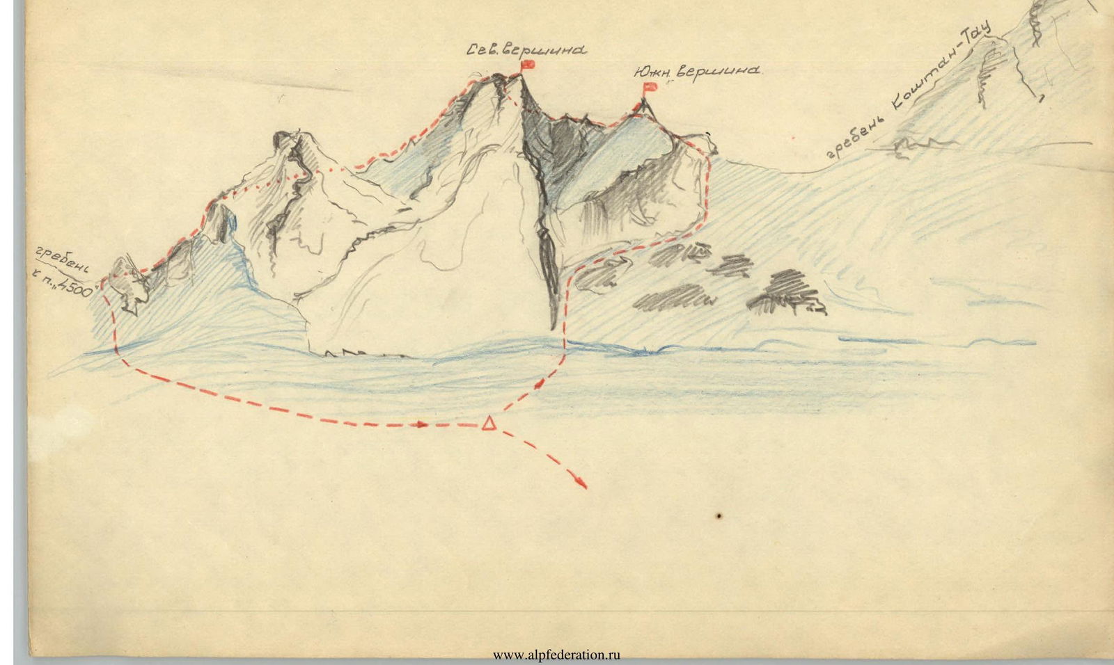
Description of Ascending to Ptitsa Peak (traversing South and North peaks) Cat. III
Day I
Early morning departure from the alpine camp. Trek via moraine, then glacier to the 3rd step of the Kundryum-Mizhirgi icefall (see route description for Koshtan-tau via North ridge, Cat. IV). Lunch and rest at the campsite on the 3rd step. Descent to the glacier and then to the upper cirque of Kundryum-Mizhirgi glacier, below Ptitsa, at 5–6 PM. The icefall leading to the upper cirque ("4th step") is traversed either near the West ridge of Kundryum-Mizhirgi peak or through a labyrinth of crevasses in the middle section. Overnight on snow below Ptitsa. Total duration on Day I: 8–12 hours.
Day II
From the campsite, ascend a snowy slope and navigate through a minor bergschrund towards a poorly defined couloir on the right side of Ptitsa massif, gradually turning into a narrow cleft. Moderate rock climbing difficulty (5 ropes). The cleft leads to a rock wall, bypassed upwards-rightwards on ice (2 ropes). Continue ascending a snow-ice slope via rock outcrops towards the saddle between Ptitsa and the ice dome on Koshtan-tau's North ridge (5 ropes). Before reaching the saddle (1.5 ropes away), veer into a narrow snowy couloir ascending leftwards. After 30 meters, the couloir becomes a steep crevice with flow ice – the route's first critical section.
Through the crevice, access the ridge left of the South peak. The peak is a 4–6 meter high rock pyramid. Ascend the pyramid from the North via a steep rock ridge – the route's second critical section. The ridge connecting South and North peaks is rocky, partially snowy, and 100–120 meters long. One section features a very sharp, inclined ridge forming the upper edge of a steeply dropping rock slab (20 meters). Reach the North peak from the East via a snow-ice couloir and a small rock outcrop (4 meters). Descend from the North peak towards the saddle between Ptitsa and Kundryum-Mizhirgi peaks along the ridge's left side (4–5 sections with sport climbing and rappelling with rope retrieval). From the saddle, descend a snowy couloir (with crevasses in the lower section) to the campsite. Relocate the bivouac to the 3rd step of Kundryum-Mizhirgi icefall for the next overnight stay.
Day III
Descend from the 3rd step campsite back to the alpine camp.
Required equipment for a 4-person group:
- Rock pitons — 8
- Ice pitons — 3
- Crampons — 4 pairs
- Hammer — 1
- Ice axes — 2
- Reepschnur (expendable) — 10 meters
Description by Smirnov A.Ya.
August 12, 1965

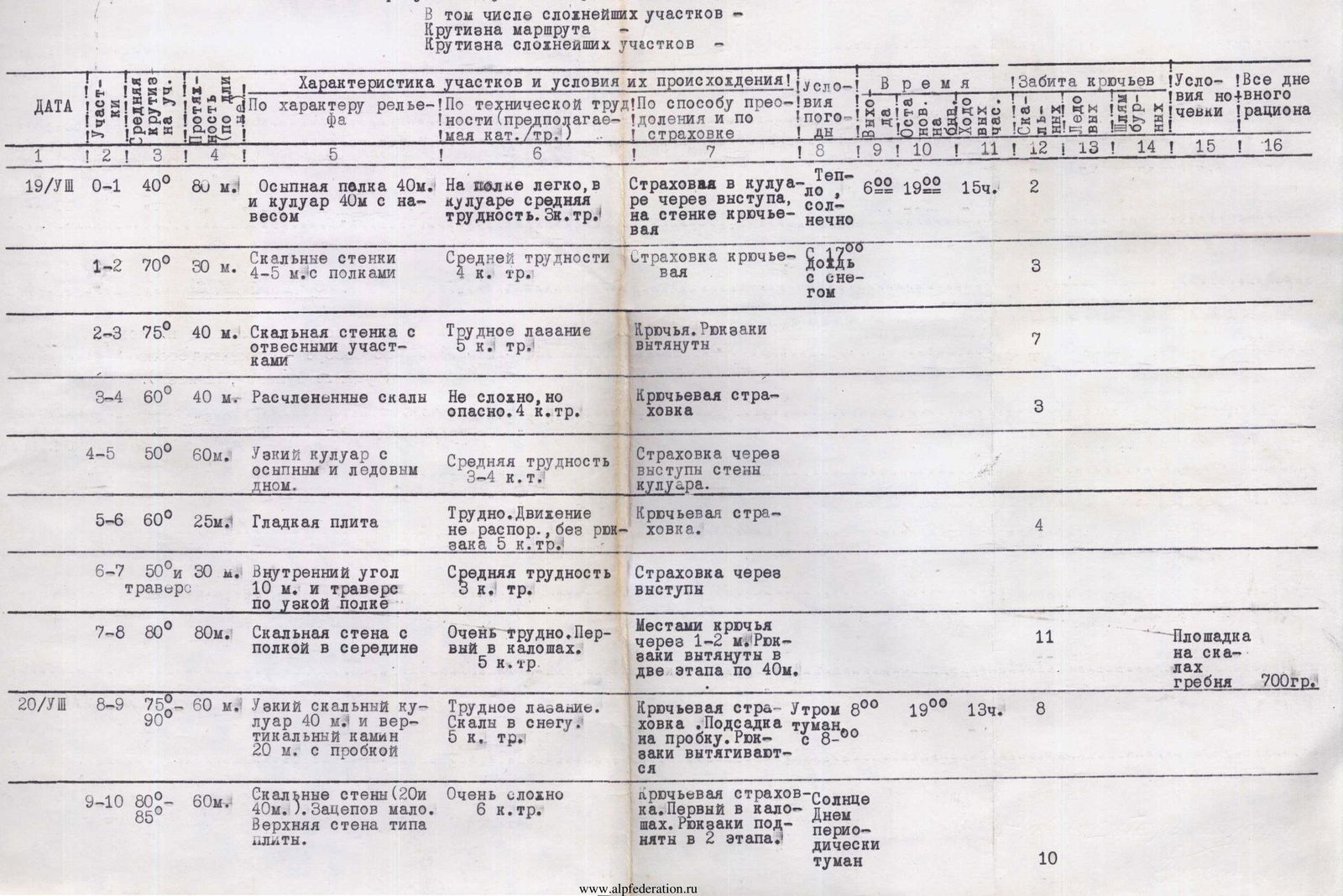
Table of Main Characteristics of the Ascent Route
Ascent route — northwest wall of p. Pioneer (Dushala gorge). Elevation gain of the route —
| Date | Sections | Average slope angle | Length, m | Terrain characteristics | Technical difficulty (cat. sl.) | Method of overcoming and belay | Weather conditions | Time (work) | Ch | Overnight stays | Pitons driven | Overnight conditions | Total workdays, h |
|---|---|---|---|---|---|---|---|---|---|---|---|---|---|
| 19/VIII | R0–R1 | 40° | 80 | Scree shelf 40 m and couloir 40 m with an overhang | Easy on the shelf, moderate difficulty in the couloir (exp. cat. sl.) | Belay in the couloir via outcrops, on the wall with pitons | Warm, sunny | 6:00–19:00 | 15 | 2 | |||
| R1–R2 | 70° | 30 | Rock walls 45 m with shelves | Moderate difficulty 4 | Pitons belay | Rain with snow from 17:00 | 3 | ||||||
| R2–R3 | 75° | 40 | Rock wall with sheer sections | Difficult climbing 5 | Pitons. Backpacks pulled up | 7 | |||||||
| R3–R4 | 60° | 40 | Disjointed rocks | Not complex, but hazardous. 4 | Pitons belay | 3 | |||||||
| R4–R5 | 50° | 60 | Narrow couloir with scree and ice floor | Moderate difficulty 3–4 | Belay via wall outcrops of the couloir | 4 | |||||||
| R5–R6 | 60° | 25 | Smooth slab | Difficult. Movement not supported, without backpack 5 | Pitons belay | ||||||||
| R6–R7 | 50° and 10° | 30 and 10 | Internal angle and traverse on a narrow shelf | Moderate difficulty 3 | Belay via outcrops | 11 | Shelf on the ridge rocks | 700 | |||||
| R7–R8 | 80° | 80 | Rock wall with a shelf in the middle | Very difficult. First in crampons. 5 | Pitons at 1–2 m intervals. Backpacks pulled up in two stages, 40 m each | Foggy in the morning | 8:00 | 19 | 8 | ||||
| R8–R9 | 75°–90° | 60 | Narrow rock couloir 40 m and vertical chimney 20 m with a plug | Difficult climbing. Rocks in snow. 5 | Pitons belay. Step-up on the plug. Backpacks pulled up | 10 | Sun during the day, periodic fog | ||||||
| R9–R10 | 80°–85° | 60 | Rock walls (20 and 40 m). Few handholds. Upper wall slab-like | Very complex 6 | Pitons belay. First in crampons. Backpacks lifted in 2 stages | ||||||||
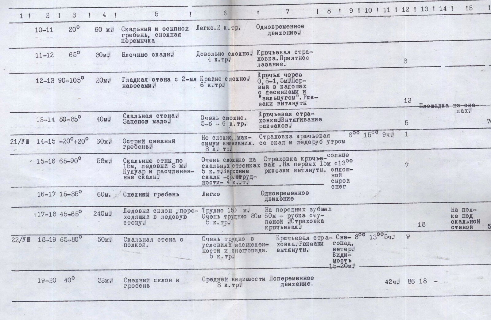
| 21/VIII | R10–R11 | 20° | 60 | Rocky and scree ridge, snowy saddle | Easy 2 | Simultaneous movement | 6:00–15:00 | 9 | 1 | 700 | |||
| R11–R12 | 65° | 30 | Blocky rocks | Quite complex 4 | Pitons belay. Pleasant climbing | 3 | |||||||
| R12–R13 | 90°–105° | 20 | Smooth wall with 2 m overhangs | Extremely complex 6 | Pitons at 0.5–1.5 m intervals. First in crampons with ladders and "Zaltsug". Backpacks pulled up | 13 | |||||||
| R13–R14 | 80°–85° | 40 | Rock wall. Few handholds | Very complex 5–6 | Pitons belay. Pulling up backpacks | 5 | Rock shelf | 700 | |||||
| 21/VIII | R14–R15 | –20°–+20° | 60 | Sharp snowy ridge | Not complex, maximum attention required. 3 | Pitons belay from rocks and ice axe | In the morning | 1 | |||||
| R15–R16 | 65°–90° | 58 | Rock walls 15 m each, ice 3 m. Couloir and disjointed rocks | Very complex on rock walls 5. Upper rocks — moderate difficulty 4 | Pitons belay. First 15 m with backpacks pulled up | Sun from 13:00, continuous wet snow | 7 | ||||||
| R16–R17 | 15°–35° | 60 | Snowy ridge | Easy | Simultaneous movement | ||||||||
| R17–R18 | 45°–65° | 240 | Ice slope turning into an ice wall | Difficult 150 m. Very difficult 80 m. 5 | Front-pointing 60 m — step-cutting. Pitons belay | 18 | On a shelf under a rock wall | 500 | |||||
| 22/VIII | R18–R19 | 65°–80° | 50 | Rock wall with a shelf | Very difficult in snowy and snowy conditions. 5 | Pitons belay. Backpacks pulled up | Snowfall, wind. Visibility 15–20 m | 8:00–13:00 | 5 | 9 | |||
| R19–R20 | 40° | 33 | Snowy slope and ridge | Moderate visibility 3 | Alternating movement | 42 | 86 | 18 |
Ptitsa Peak Cat. III