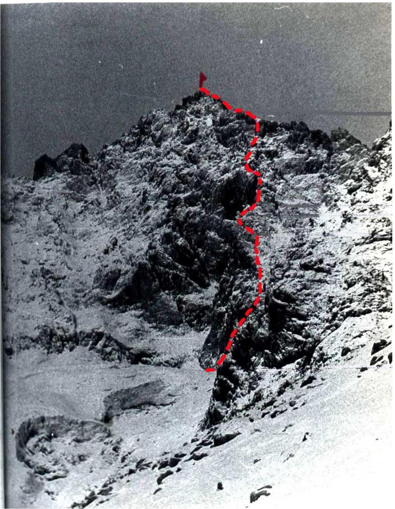
Ascent of Misses-Tau via the right counterforter of the East face, 5B cat. diff. (Climbing report)
From the base to the campsite at the turn of the glacier under the base of the SE ridge of p. Brno — 2.5–3 hours. From here, along the edge of the 3rd branch of the Mizhirgi glacier (Cheget-Mizhirgi) to the icefall.
Then:
- Ascend to the upper cirque via "ram's foreheads" and moraine slopes to the right of the streams.
- On the moraine ridge of the upper cirque — the initial bivouac site, 1.5–2 hours from the turn.
From the bivouac, ascend the moraine slope and snow (ice) to the glacier plateau under the E wall. Across the plateau, move left along the rocks towards the debris from the couloir between the left and right counterforts of the E wall. Up the avalanche cone to the throat of the couloir. Via "ram's foreheads" to the right, 15 m under the wall — a shelter. 65–75 m up and to the right on smoothed, partially grass-covered, fairly difficult rocks, under the overhanging wall to the right of the water runoff. Traverse left (12–20 m) and then bypass the overhangs to reach a wide green ledge under the broad wall that blocks the ascent. From the start of the rocks to this point — 130 m.
The wall on the right is cut by a vertical inner corner. For this part of the ascent and further, it is convenient for the first climber to wear galoshes. 50 m up the inner corner of medium and then high difficulty under an overhang to the right of the cornice. Exit through the overhang into the corner (very difficult), formed by a vertical wall on the right and a slab. The first climber's backpack is pulled up. Ahead, the path is blocked by a massive cornice, so move right-up on the slabs, sometimes on small ledges, to a convenient ledge (30–40 m). Behind the corner, 20 m up a wide inner corner-chimney with a 3–4-meter overhanging very difficult wall (pulling up the first climber's backpack). Exit onto a ledge with snow, under a belt of vertical rocks with water runoff. Traverse left 20 m, then up 20 m on a difficult wall. The outer corner is bypassed left-up (25 m). The path up to the ridge is blocked by absolutely smooth rocks, and it is necessary to move left, crossing a complex steep snow-ice couloir (15 m). Exit into the "cockscomb" ridge gap of the counterforter onto a snow saddle. Here is a convenient spot for an overnight stay. There are many suitable spots for overnight stays on the counterforter, especially sitting ones.
From the gap, the route follows an even more complex part of the ridge. 35 m of very difficult climbing straight up on smooth steep slabs-walls. Here, it is possible to traverse right about 30 m with some descent, and then ascend via inner corners. Exit onto a rocky platform (2×2 m) on the ridge. Traverse 5 m right on a good ledge to a 20-meter inner corner with a steepness of up to 80–85° and patches of growing grass at the bottom. Its smooth sides, particularly the overhanging middle and upper part of the right face, are very difficult. The first climber goes without a backpack. 6–8 m after reaching the ridge, there is a convenient ledge for belaying. Here is a control cairn.
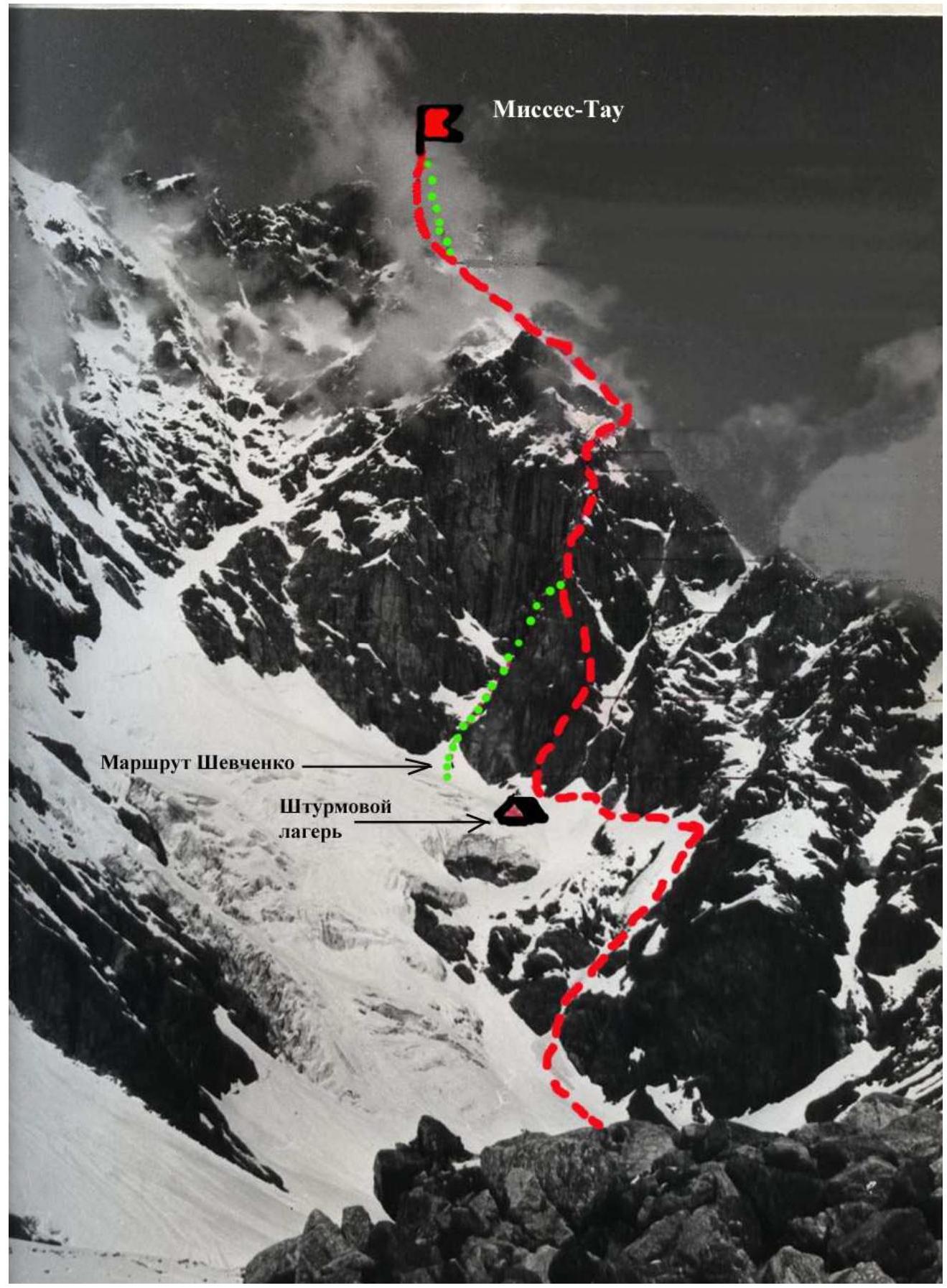
15–20 m above, the ridge is blocked by a cornice with an overhang of about 3 m. It is bypassed by complex climbing as follows. Up about 3 m, then traverse right behind the wall (the first climber goes without a backpack) and further up about 15 m. Exit onto a wide, descending right-down ledge, along it about 20 m under a vertical inner corner-chimney with live rocks. 25 m of complex climbing up, then 15 m of easier rocks. Further, there are 80–100 m of rocks of medium difficulty, interrupted by snowfields. The route becomes more gentle and turns left (from above over the "mirror"), approaching the wall of the NE counterforter. At the same time, moving right is blocked by a steep and very dangerous, seemingly complex, couloir. Movement along the ridge on difficult, smooth, almost crack-free rocks is complicated by snow. About 60 m further, the path is blocked by a gendarme, which is bypassed on the right (40 m), traversing the wall, then along a lateral steep ice couloir (80°), covered with snow overhangs, crossing a vertical snow ridge-knife that divides the couloir into two parts along its length, and further up on sheer rocks onto the "forehead". Technically and psychologically very complex section, one of the key points of the route. Backpacks were pulled up. Then 60 m along the ridge, on rocks and snowfields under a new ascent. About 60–70 m of complex rocks, after which there is a series of easy ledges leading left-up, bypassing the wall of the NE counterforter (160–200 m). Further, 140 m of rocks of medium complexity, partially complex. This section is characterized by the presence of live slabs, often quite large, and requires special attention when passing. On a snowy shoulder before exiting onto a 100-meter snow ascent leading to the ridge of the NE counterforter, the group organized an overnight stay. We believe that at this point, the route along the eastern wall of B. Garf converges. The 100-meter snow ascent leading to the ridge of the counterforter is essentially the right side of a broad snow-ice couloir descending onto the Mizhirgi glacier.
Further — according to description 1. The route logically breaks down into the following sections (see photo and table):
- R1
- R2
- R3
- R4
- R5
R0–R1: snow path from overnight stays to the gorge; R1–R2: 4 ropes on the right part of the throat; R2–R3: inner corner, under an overhang; R3–R4: exit from under the overhang to the right; R4–R5: corner-chimney with a 3–4-meter overhanging wall; R5–R6: snow ledge 20 m with exit under the wall; R6–R7: 2-meter wall of complex climbing with ladders; R7–R8: outer corner 25 m; R8–R9: steep snow-ice couloir, 15–20 m of complex climbing; R9–R10: steep slab-wall 20 m, complex climbing with ladders; R10–R11: inner corner 15 m, complex climbing with ladders; R11–R12: very difficult 5-meter chimney, traverse right 5 m, inner corner with a slit, exit onto a "platform", traverse right 5–7 m on a good ledge under a complex inner corner; R12–R13: inner corner-chimney with partially overhanging faces; R13–R14: medium, partially complex climbing from the control cairn 25 m to a ledge, along the ledge right 20 m; R14–R15: inner corner-chimney, 25 m of complex climbing, 15 m of easier rocks; R15–R16: rocks of medium complexity with snowfields; R16–R17: steep slab to the base of the gendarme; R17–R18: bypassing the gendarme on the right along the rocky wall and vertical snow-ice couloir; R18–R19: 70–80 m of complex rocks; R19–R20: traverse left-up over the "mirror" of the wall 160–180 m on easy rocks; R20–R21: 140 m of rocks of medium complexity with complex and difficult sections (live rocks); R21–R22: 100-meter exit onto the ridge of the counterforter on a snowy avalanche-prone slope; R22–R23: 200 m of snowy slope under the tower; R23–R24: 40 m of complex climbing on the center of the tower; R24–R25: 40 m up and traverse left on destroyed rocks; R25–R26: 40 m of difficult climbing with ladders — inner corner-chimney with live rocks; R26–R27: 40 m initially complex, then medium complexity climbing on destroyed rocks; R27–R28: first 40 m on destroyed rocks of medium complexity, then exit onto a snowy ridge leading to the summit; R28–R29: 50 m on the snowy ridge to the summit.
Passport
Ascent of Misses-Tau via the right counterforter of the E wall (Leningrad Alpine Championship 1976)
- Climbing category — technical.
- Climbing area — Central Caucasus, Bezengi valley, "Bezengi" alpine camp.
- Climbing route — Misses-Tau (4320 m) via the right counterforter of the E wall, approximately 5B cat. diff.
- Characteristics of the ascent: route length 1850 m; height difference 1000 m; average steepness of the route — 53°, wall sections — 70°; length of complex sections 750 m.
- Pitons hammered: rock — 124, ice — 3, bolted — not used.
- Number of climbing days — 3 (not counting 1 day for preparation and 1 day for descent)
- Number of climbing hours — 30
- Number of overnight stays and their characteristics — 3.