ASCENT TO THE SUMMIT OF VOSTOCHNAYA MIZHIRGI VIA THE SOUTH FACE (FIRST ASCENT)
The ascent was made by the group of the Moscow City Council of the DSO "TRUD" consisting of:
- FINOGENOV M.A. — Master of Sports (leader)
- Puchkov L.N. — 1st sports category (participant)
- Tkachenko A.N. — 1st sports category (participant)
The group was on the route from July 8 to July 14, 1963. Base — "Bezengi" alpine camp.
The route (traverse of Vostochная and Zapadная Mizhirgi peaks) with ascent to Vostochная Mizhirgi via the South face was planned as a training traverse of both Mizhirgi peaks before the ascent claimed for the USSR championship, and was carried out in conjunction with the group of the DSO "TRUD" from Leningrad led by SOLONNIKOV V.A.
ROUTE TAKEN BY THE GROUP VIA THE SOUTH FACE OF VOSTOCHNAYA MIZHIRGI
The South face of Mizhirgi has attracted the attention of our sports group over the past few years. This massif, never climbed before, is of great interest. During a training ascent to the summit of Krumkol from the south, we thoroughly examined the face of Mizhirgi peak and outlined several options for the first ascent. Photographs and sketches were made.
GENERAL CHARACTERISTICS OF THE ROUTE
The ascent starts from the upper plateau of the Krumkol glacier. The South face of Vostochная Mizhirgi (4927 m) is bounded on the left by a large snow-ice couloir separating it from the south ridge of Zapadная Mizhirgi, and on the right by a narrow icy groove separating the face from the rest of the massif.
In the lower part of the face, two counterforts are clearly visible, separated by a steep snow-ice slope (50°). The initial part of the route goes along the right counterfort.
Route characteristics:
- Type: combined, with a predominance of rock
- Elevation gain: about 1000 m
- Average steepness of the South face of Vostochная Mizhirgi: 70°
Rock character:
- In the lower part of the face: monolithic, with few handholds;
- In the upper part: heavily fragmented rocks of large structure, interspersed with snow and ice.
Group's assessment of the route: 5B category of difficulty.
ROUTE PROGRESSION
First day
The group left the "Bezengi" alpine camp at 6:00 AM and stopped for a bivouac at the Austrian bivouac sites at 12:00 PM.
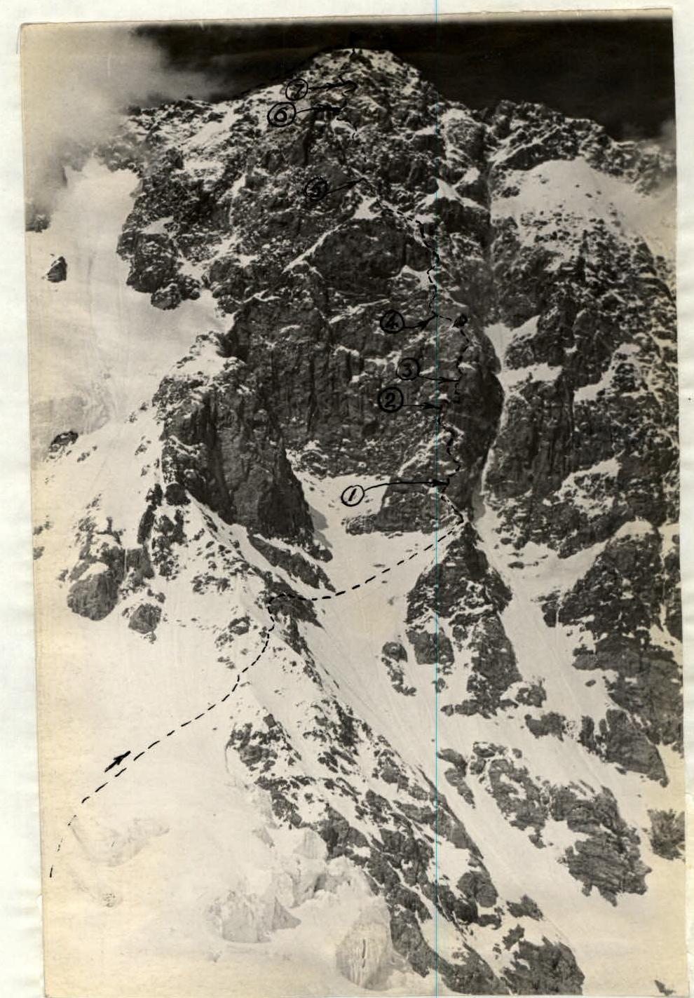
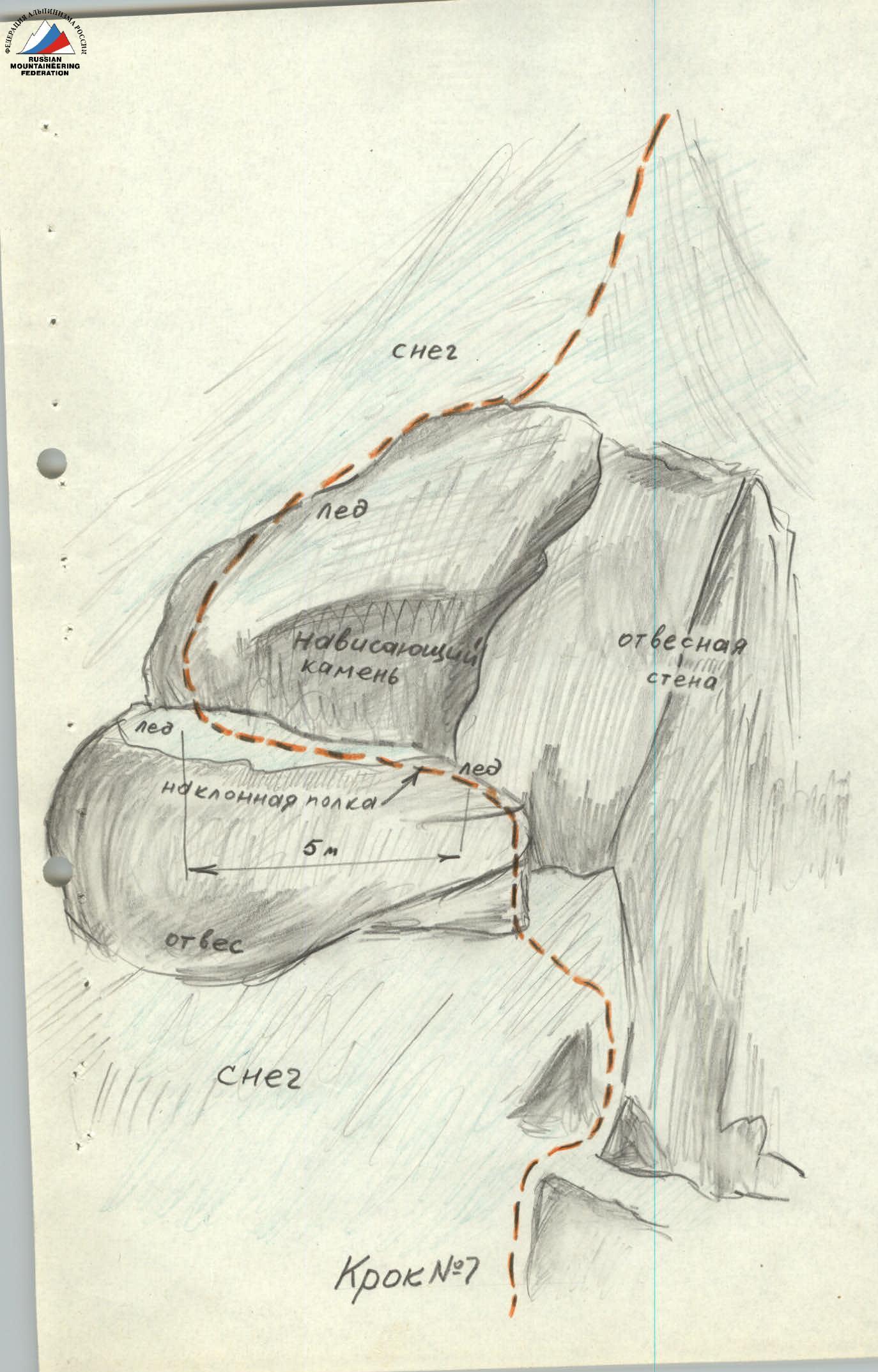
LOWER SECTION OF THE ROUTE TAKEN ON THE THIRD DAY

Second day
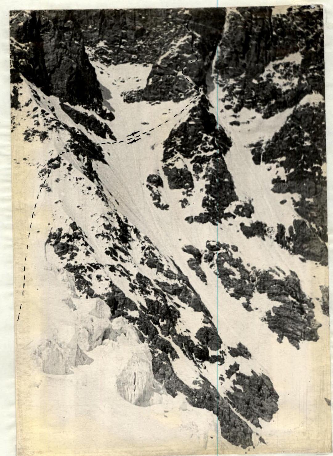
Leaving the Austrian bivouac sites at 6:00 AM, our group reached the Spartak pass by 1:00 PM, located on the ridge of Bashha-auz-bashi-Aman-Kaya, which separates the Krumkol and Dykh-su glaciers. The group set up a bivouac on the Spartak pass. The day had excellent weather, and the entire route was observed through binoculars. The rest of the day was spent observing the face and refining the ascent route.
Third day
At 9:00 AM, the group started processing the approaches to the face and the lower part of the route. Initially, the path goes across the upper plateau of the Krumkol glacier from the Spartak pass, bypassing the icefall under the left counterfort of the South face. Then, it ascends a steep snowy slope (45°, three ropes) onto the left counterfort and climbs its left part (two ropes). Crossing the left counterfort, the group proceeds along moderately difficult, fragmented rocks (one and a half to two ropes) to a steep snowy slope, which is a continuation of the face and is bounded by the left and right counterforts. The path then goes right-upward under the rocky base of the right counterfort. On snow with a slope of up to 50° (7 ropes), protection was provided through an ice axe. Soft snow allowed for good step-kicking. After 3.5 hours, the group reached under the face. A large gray rock 1.5 m from the face served as a landmark. A 15-meter wall was climbed right-upward. The climb was very difficult. The first climber ascended without a backpack, using artificial holds. Then, a traverse right along a narrow ledge with overhanging rocks (25–30 m) was made (8 pitons were hammered, and small three-rung ladders were used). (Step #1). The path then proceeded along steep rock slabs left-upward, overcoming a 5-meter sheer wall, and the group reached a small snowy shoulder under a quartz wall (this spot is visible due to a characteristic wide yellow quartz band). Protection was provided by pitons (4 pieces). The quartz wall was the key section of the route. From this point, the group returned, leaving ropes and ladders at the most challenging sections of the route, to the bivouac on the Spartak pass.
The observations from this day can be summarized as follows: The South face of Vostochная Mizhirgi is divided into several characteristic sections.
- Ascent to the ridge. 10–12 ropes from the icefall (snow, ice, fragmented rocks, overall slope 50°).
- Upper part of the right counterfort (3–4 ropes). Here, there are snowy rocks of moderate difficulty (50–70°).
- Lower part of the face — sheer or nearly sheer. A characteristic feature is a horizontal quartz vein, a yellow band in the middle (a section of five ropes).
- Slabs with few handholds (4–5 ropes). In places, the slabs have snow.
- Above a small snowy shoulder, steep rocks turning into individual walls, some overhanging. All are deeply snow-covered. This section from the shoulder to the summit — 15 ropes.
The chosen route is not avalanche-prone.
Fourth day
Leaving the bivouac at 4:00 AM, the group followed the established tracks to the counterfort and, by 6:30 AM, reached under the quartz wall via the route processed the previous day.
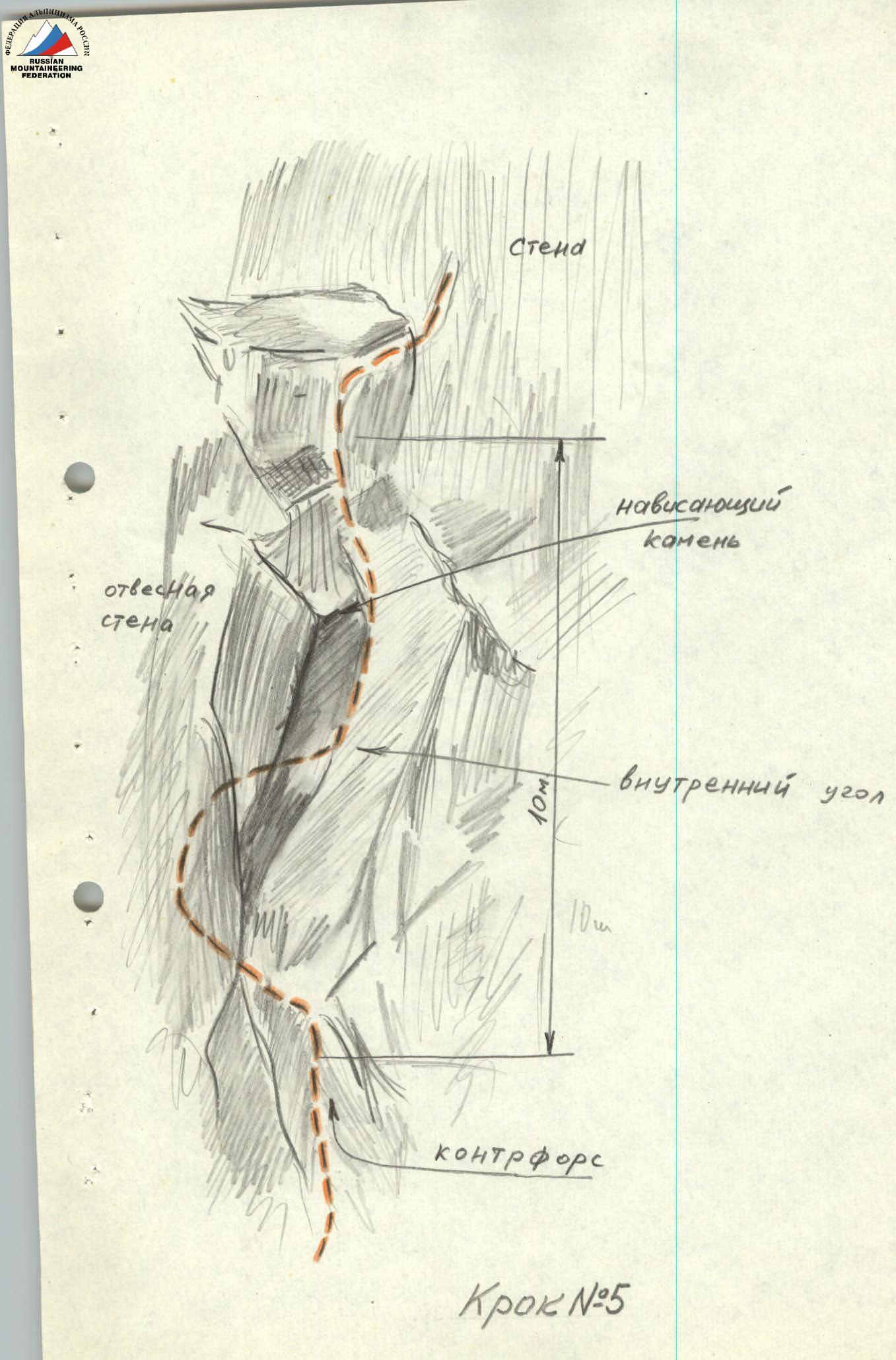
The first 40 m of the wall were climbed via a vertical internal corner with negative sections. Climbing was very challenging; the first climber ascended without a backpack, using artificial holds (10 pitons were hammered, 3 were bolted). Other group members used a 25-meter ladder.
It should be noted that climbing a 25-meter ladder made of rope is extremely difficult and tiring, especially on negative sections. (Step #2).
Then, the group exited via a crack. From the crack, a traverse right along a narrow inclined ledge (30 m) was made, starting with an overhanging rock; protection was provided by pitons (6 pieces). Further, along a smooth sheer wall, along a narrow crack turning into an internal corner.
Climbing on this section was very challenging, with the use of artificial holds (belays, ladders, pitons). Other group members used a long ladder. On this wall, 11 pitons were hammered, two of which were bolted. (Step #3).
The group then moved two ropes:
- first, along a rocky groove towards the crack;
- then to a shoulder under inclined slabs (8 pitons were hammered).
This shoulder is a small (12–15 m) snowy ridge with a slope of 30–35°, where, as previously assumed, it was possible to set up a bivouac. Up to this point on the route, there was no suitable spot for a satisfactory overnight stay on the face.
By 7:00 PM, we set up a bivouac and managed to process the challenging section of the further route (difficult slabs with few handholds). They were climbed two ropes up-left (8 pitons were hammered, a rope and a rappel rope were left). (Step #4).
Fifth day
The bivouac was packed up, and the group departed at 6:00 AM. By 7:00 AM, having climbed the processed section of the route, they reached snowy slabs. Protection on the snow, which had not yet softened and held well, was provided through an ice axe.
The group then moved towards fragmented rocks to the right of the shoulder. The direction was right-upward along the face, filled with snow and ice. Climbing was difficult. 3 pitons were hammered.
Beyond this wall, fragmented rocks began, dangerous due to "live" rocks.
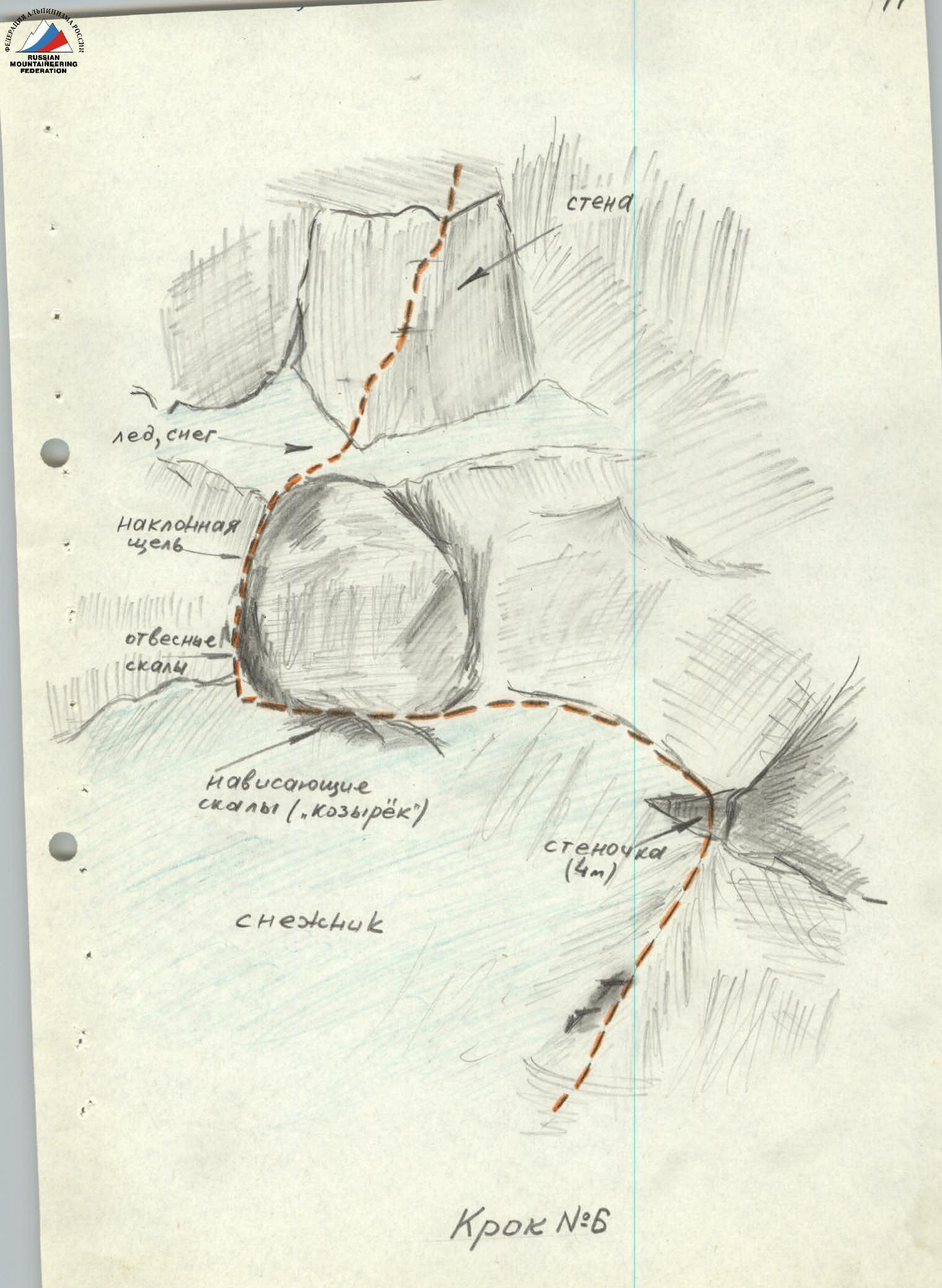
The path then traversed steep snow lying on slabs, left-upward, towards a rocky ridge. On the ridge, protection was provided by pitons (5 pieces).
The group then ascended along the rocky ridge, using outcrops for protection. After 40 m, they reached under an internal corner with an overhanging rock. While overcoming this spot, the first climber ascended without a backpack, using small ladders. 4 pitons were hammered, and after a 10-meter wall, protection was provided through ledges.
From here, the direction was towards a sharp rock (Step #5), resembling a "Trident." The "Trident" was bypassed on the left, along a four-meter wall (climbing was difficult, 4 pitons).
From this point, the group moved along slabs along the boundary between snow and a rocky wall in the direction of an "awning" (an overhanging rock 5 m long, 2 m wide). Protection was provided by pitons and outcrops. On these sections of the route, the overall direction of movement was upward and slightly left.
Beyond the "awning," the route proceeded along a crack (5 m high), filled with snow and ice. It was already 2:00 PM, and the snow had softened, holding poorly. The crack was a difficult passage, where ladders were used (6 pitons were hammered).
After the crack, a wall was climbed. Climbing was difficult. The greatest difficulty was overcoming overhanging rocks.
Movement towards a snowy ridge proceeded along smooth slabs covered with ice (ladders were used, a bolted piton).
A snowy ridge (Step #7) led under a wall further upward, along snowy rocks consisting of large boulders. Protection was provided through outcrops. The direction was towards an overhanging rock 7 m high.
Beyond the rock, there was a snowy slope, along which one rope led to the summit. The group reached the summit of Vostochная Mizhirgi at 5:00 PM. After writing a note and resting, the group descended to the plateau (4–5 ropes) between the Zapadная and Vostochная Mizhirgi peaks. Here, they set up a bivouac. The weather was deteriorating.
Sixth day
Due to the onset of snowfall, it was decided not to proceed to Zapadная Mizhirgi. The group began their descent at 8:00 AM.
Traversing the slopes of Zapadная Mizhirgi on the left along ledges, the group reached the usual route of the Sella-Zapadная Mizhirgi pass, along which they descended. This route was familiar to them, as group members had traversed it several times before.
By 6:00 PM, the group was at the Austrian bivouac sites.
Seventh day
Return to the "Bezengi" alpine camp by 2:00 PM.
The ascent was successful and conducted at a good sports level. The group demonstrated itself as a cohesive sports team. It should be noted that our ascent took place in excellent weather, which prevailed throughout these days in the Bezengi region. Taking advantage of the good meteorological conditions, our group quickly and clearly carried out this challenging ascent (except for the last two days).
Climbing the South face of Vostochная Mizhirgi requires a large volume of technically complex work and is very labor-intensive. 89 pitons were hammered on the face, some of which were bolted. Three-rung and 25-meter ladders were used multiple times.
The overall complexity of the route is significantly higher than that of all rock routes in the Bezengi region previously climbed by group members:
- East Dykh-Tau from the south — 5A category of difficulty;
- Main Dykh-Tau from the south — 5A category of difficulty;
- Zapadная Mizhirgi from the south — 5A category of difficulty.
Individual rock sections are more complex than the most difficult spots on routes such as:
- Krumkol via the SW wall — 5B category of difficulty;
- Vostochная Mizhirgi via the north ridge — 5B category of difficulty;
- Koshtan-Tau via the Kolishevsky route — 5B category of difficulty,
which were also previously climbed by individual group members.
The upper part of the route, in terms of rock structure and climbing technique, resembles the north ridge of Shkhara, also previously climbed by group members.
Our sports group and the valley commission of the Bezengi region classified the route as 5B category of difficulty.