Ascent Passport
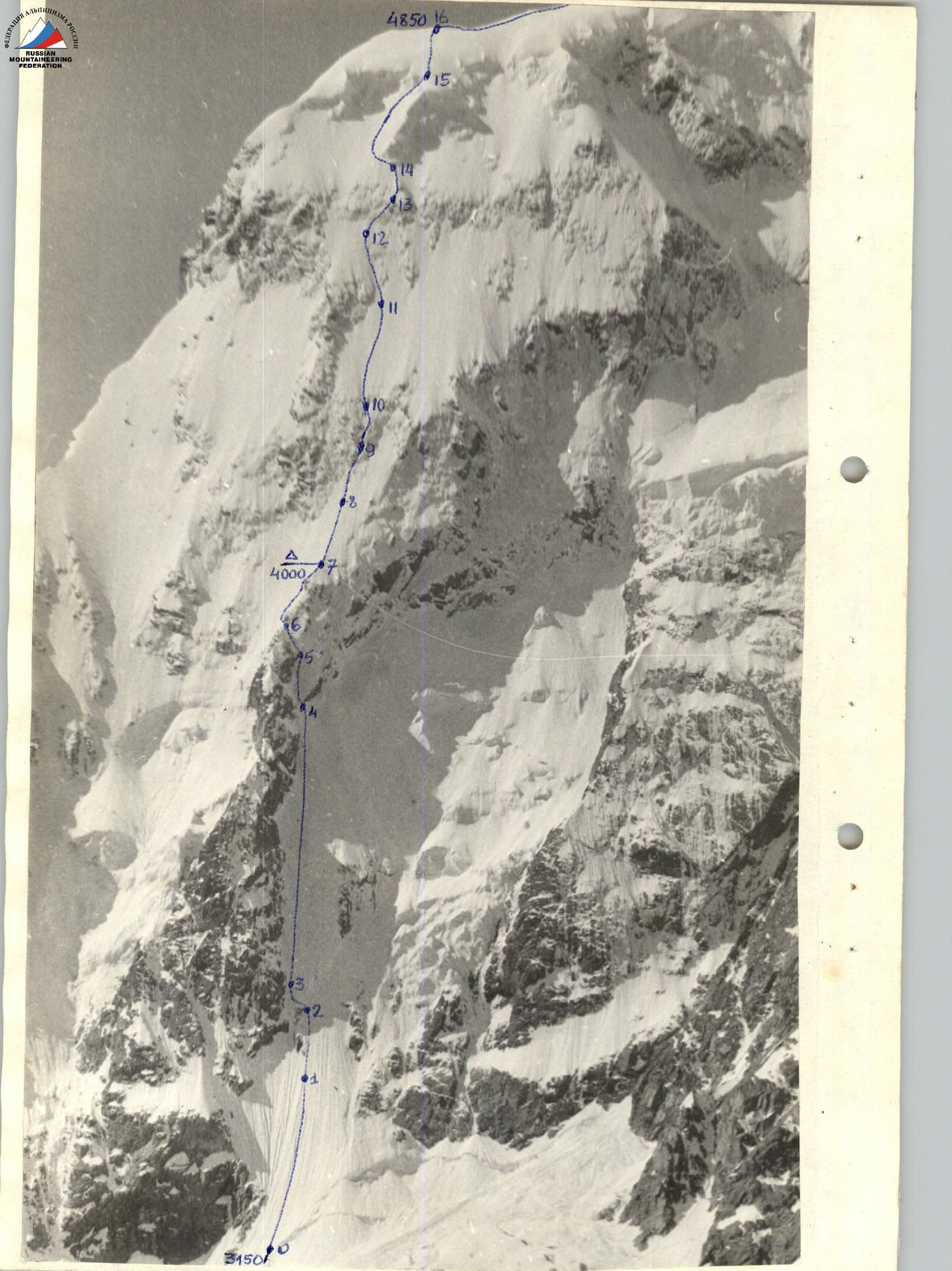
I. Ice and Snow Ascent Category 2. Central Caucasus, Bezengi 3. Eastern Mizhirgi via the Center of the North Face (V. Grishchenko route) 4. Estimated 5B category of difficulty, 2nd ascent 5. Elevation gain — 1700 m, route length 2090 m.
Length of sections with 5–6 category of difficulty — 1680 m. Average steepness — 55°.
-
Pitons driven: rock: 2; bolt: —; chocks: —; ice screws: 218.
-
Time to the summit — 23 hours and 2 days.
-
Overnight stops: 1st — platform carved into the snow and ice slope; 2nd — in a snow depression behind the summit.
-
Leader: Anatoly I. Trasevich, Master of Sports of the USSR, Kharkov. Team members:
-
Yuri N. Ovsyannikov, Master of Sports of the USSR, Kuibyshev;
-
Vladimir Yu. Akifyev, Candidate for Master of Sports, Moscow;
-
Vladimir V. Zhuravlev, Candidate for Master of Sports, Kuibyshev;
-
Nikolai I. Maneev, Candidate for Master of Sports, Kuibyshev;
-
Evgeny Yu. Sdobnikov, Candidate for Master of Sports, Moscow.
-
Coach: Igor B. Kudinov, Honored Coach of the RSFSR. II. Departure to the route: August 17, 1982.
Return from the route: August 19, 1982.
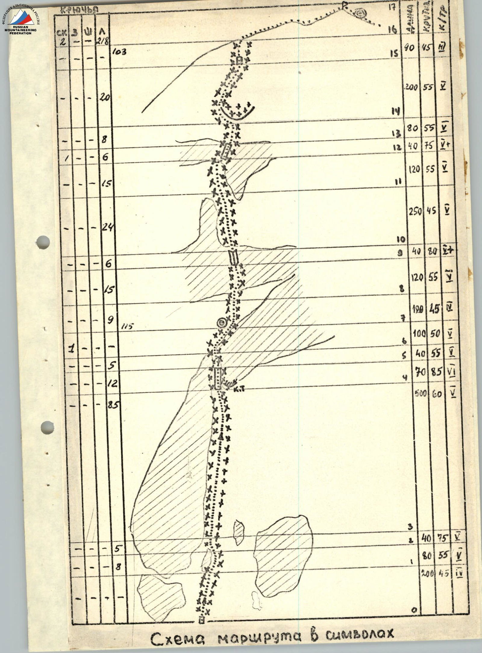
Route diagram in symbols

Route Description by Sections
R0–R1. The entire route is traversed in crampons. The route begins by overcoming the bergschrund, followed by a very dense snow slope with gullies. Belay — through an ice axe. R1–R2. Thin layer of snow on hard ice. R2–R3. Rocky belt covered with 10–15 cm of ice flow. Individual sections up to 85°. R3–R4. Steep ice slope. Ice is hard. In some places, a thin layer of ice. Steepness in some areas up to 70°. R4–R5. Steep (up to 90°) rocky belt. Very hard ice flow. Control cairn to the right of the ascent path under the overhanging rocks. R5–R6. Steep ice couloir. Exit to the "neck" of the "balalaika". First opportunity to stand normally. R6–R7. To the left of the rocks along the snowy slope. Snow is deep and loose. R7–R8. Weakly defined snow and ice ridge leading to the rocky belt. R8–R9. Steep ice on the rocks. The layer of ice is sufficient for ice screws. R9–R10. Steep rocky belt (up to 85°). The layer of ice is thin and unreliable. R10–R11. Snow and ice slope. Movement straight up. Snow layer is thin. Ice is very hard, and in some areas, the rocky base is close. R11–R12. Ice couloir, then slope. Movement to the left and up, bypassing the rocks. R12–R13. Steep rocky belt covered with ice. To the right and up. R13–R14. Snow and ice slope. Leads to the ice drop. R14–R15. Bypass the drop and then exit onto it from the left. Steep hard ice. R15–R16. Through the bergschrund wall (2 m) exit onto the snowy slope and then onto the ridge. R16–R17. Along the ridge to the east, through an uncomplicated gendarme to the summit of Eastern Mizhirgi.