Passport
-
Ice-snow class.
-
Caucasus, Mizhirgi gorge.
-
East Mizhirgi via the left part of the North wall (4918 m).
-
Assumed 5B category of difficulty, first ascent.
-
Elevation gain: 1800 m, length 2630 m. Length of sections with 5–6 category of difficulty — 1110 m. Average steepness of main sections — 57°/1830 m. Length of wall section — 2230 m.
-
Pitons hammered: rock 17, drilled 0, chocks 11, ice screws 157, snow stakes 20.
-
Team's climbing hours: days – 3 climbing hours – 30.5
-
Overnights: I — in a bergschrund on a snow platform; II — sitting in a tent, platform carved at the boundary of rocks and ice above the third rock belt.
-
Leader: Vladimir Andreyevich Khitrikov — Candidate for Master of Sports Team members:
- Ivan Ivanovich Kachur — Candidate for Master of Sports
- Viktor Borisovich Brimov — Master of Sports
- Viktor Igorevich Shardin — Candidate for Master of Sports
-
Coaches: Senior coach Viktor Alekseyevich Shabokhin — Master of Sports Viktor Ivanovich Yeletsky — Master of Sports
-
Approach to the route: August 11, 1982. Summit: August 13, 1982. Return: August 14, 1982.
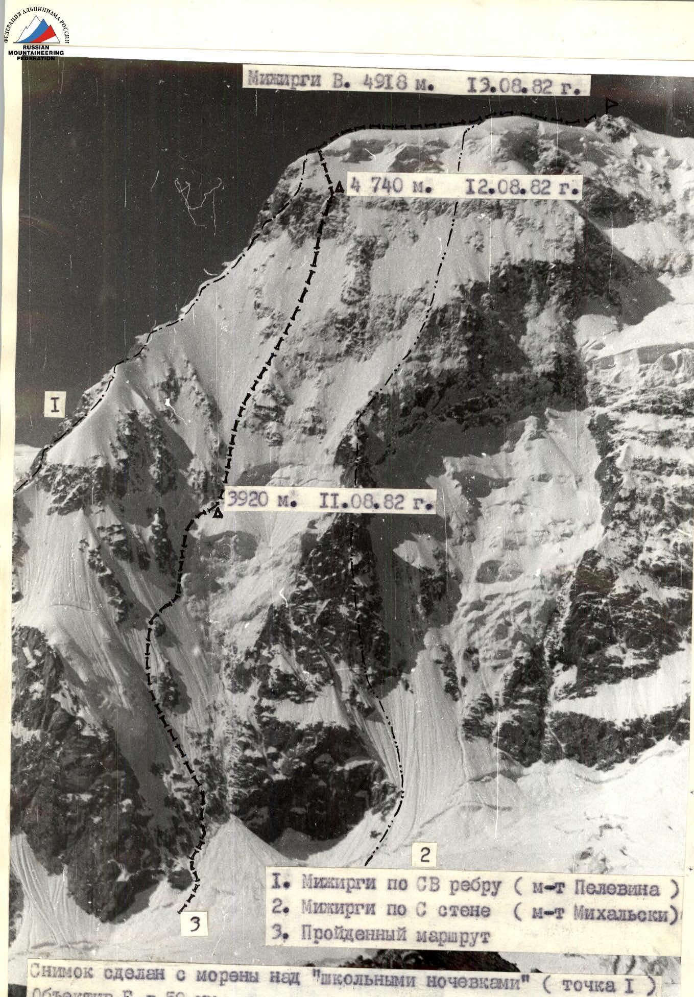
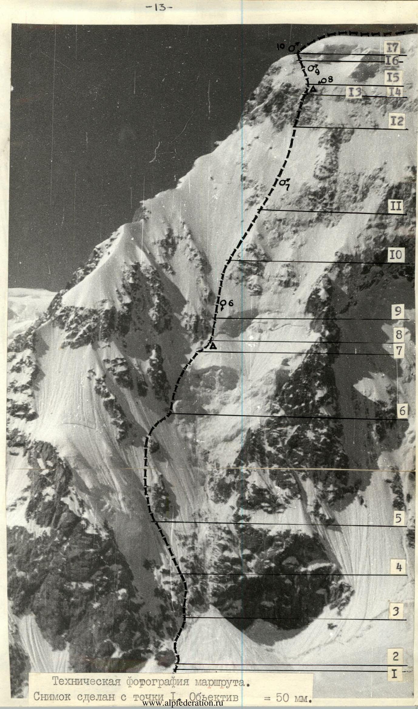
Photo 1
Mizhirgi V. 4918 m. August 13, 1982.
- Mizhirgi via NE ridge (Pelevin's route)
- Mizhirgi via N wall (Mikhalski's route)
- Climbed route The photo was taken from the moraine above the "school overnight stays" (point 1). Lens F = 50 mm.
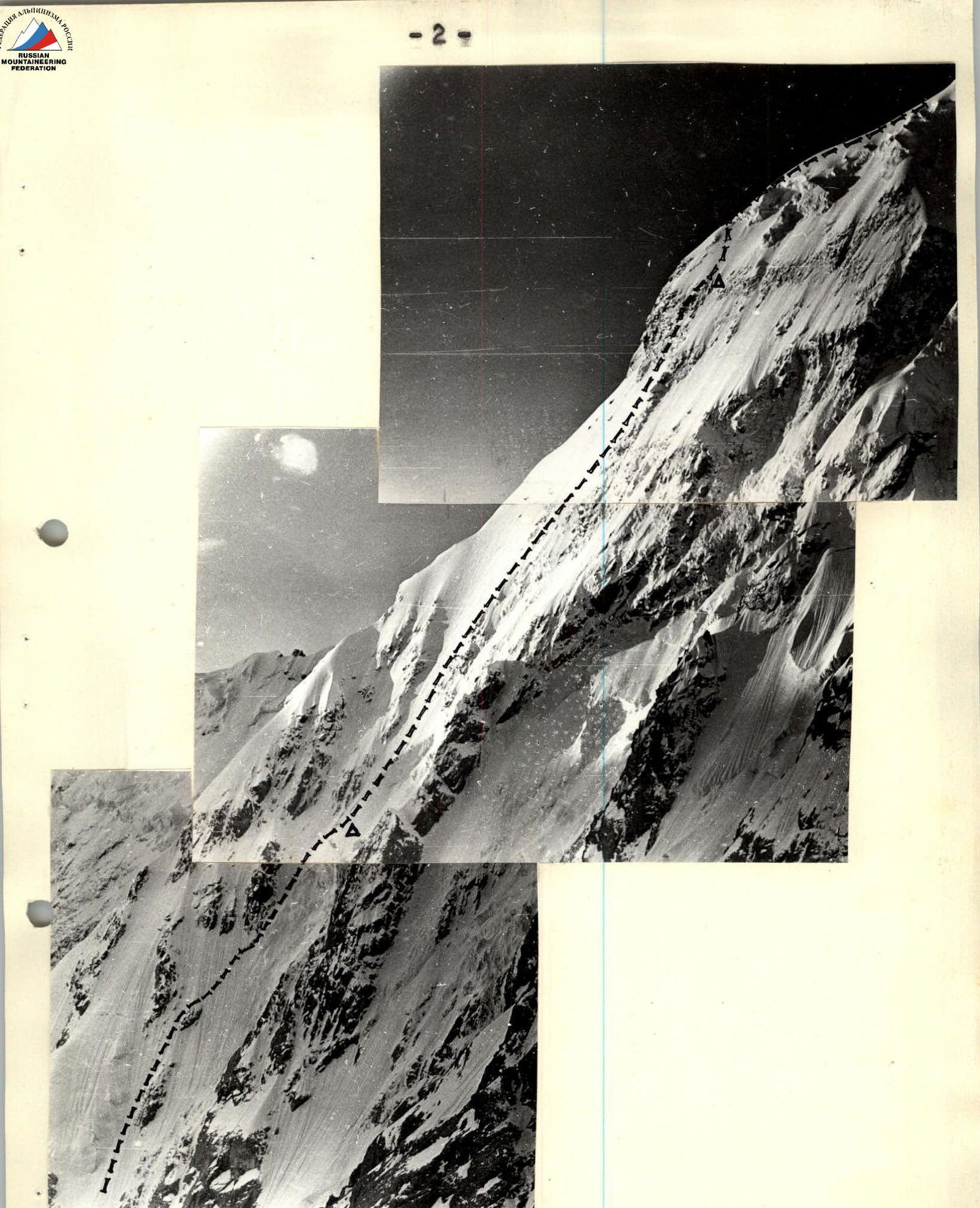
Photo 2
Profile of the wall on the right. The photo was taken from the summit of Missis-Tau (point 3). Lens F=135 mm.

Photo 3
Profile of the wall on the left, taken from Tikhonov's point (point 2). Lens F=50 mm.
Photo 4
Photopanorama of the area. The photo was taken with a lens with a focal length F=50 mm. Distance to the object ~6 km. Height of the shooting point ~2800 m (point 4).
Tactical actions of the team
In accordance with the developed tactical plan, the team left the camp in the right (orographic) pocket of the Mizhirgi glacier at 00:00 on August 11. They quickly approached the start of the route via a previously scouted path. The team began working on the route at 02:00.
During the ascent, they used:
- natural light (the moon was in a favorable position);
- headlamps — for the first climber in each rope team;
all this allowed them to move in the dark without significant time loss. The first rope team, as planned, was Khitrikov — Kachur.
The route begins with a bergschrund, which they overcame by descending onto a snow plug and then ascending through a 5-meter sheer wall using "ice hooks." Belays were organized on this section.
Next, moving as planned along the rocks on the left part of the avalanche cone, they ascended to the first rock belt (2–3, PHOTO 1). The exit point to it (clearly and accurately determined during observations) was between two gullies, closer to the left one, which did not show any activity during observations (did not "send down debris"). The passage of this section was complicated by the presence of rimed ice and snow crust on rocks resembling "sheep's foreheads." The ice on the route was very dense, and screwing in ice screws, the sharpness and quality of which were tested on many ascents, required significant physical effort.
By changing the lead every 5–8 ropes, the first rope team left screwed-in ice screws for the second team. This movement scheme was practiced during training ascents and was likely the most optimal for working on snow and ice terrain.
By 15:00, they reached the "roof" of the right gully, where they set up camp in a bergschrund as planned. The overnight stay was comfortable and well-protected by a rock island above. There were no suitable places for a comfortable overnight stay on the route before this point.
August 12. They started moving at 8:30. It was cloudy in the morning. They approached the bergschrund through deep snow, which separated the mobile part of the gully from the main wall.
The first rope team to work, according to the tactical plan, was Yefimov — Shardin.
After the bergschrund, an ice slope began with no flattening (8–11). Adhering to the practiced tactic — changing the lead every 5–8 ropes — they moved upwards. The entire section was traversed on the front points of their crampons.
On this section, the advantage of boots with stiff soles, which two team members had, was particularly noticeable.
In the afternoon, the weather deteriorated, with snow starting to fall and wind picking up. Visibility occasionally decreased to 10–15 meters.
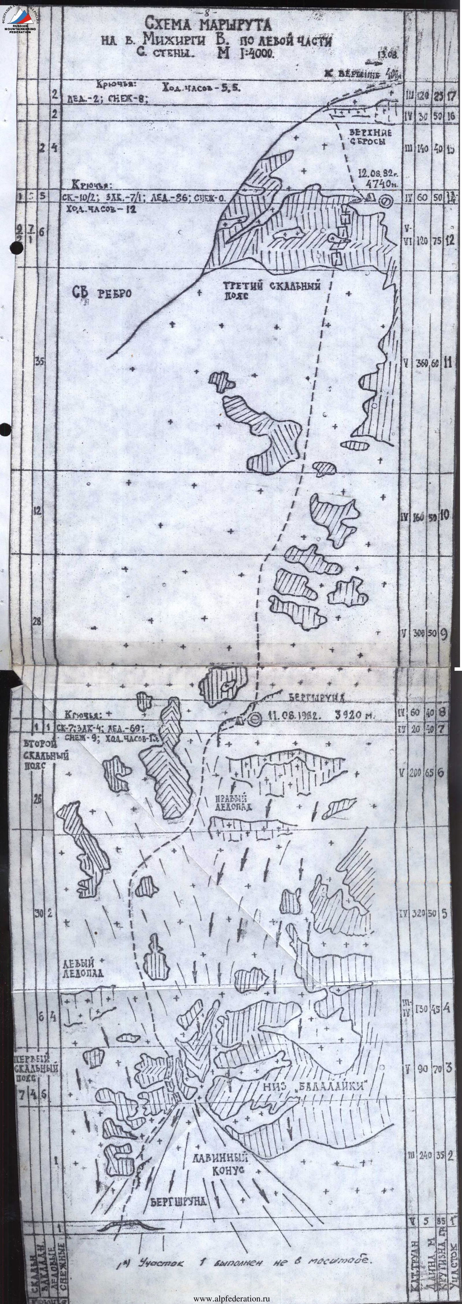
They approached the third rock belt. An overnight stay was planned here, but there was no suitable place. Steep, clean ice met even steeper rocks. They decided to overnight above the third rock belt.
It was also clear that traversing left under the "ice room" was not logical, as the rocks in the chosen passage were complex but passable. The remaining daylight allowed them to pass the belt and overnight before the final snow and ice slope.
Snow-covered, steep rocks with rimed ice were overcome as planned using special ice screws (flexible and shortened ice screws): on rimed ice — with ice screws; on rocks — with chocks.
On this section (11–12), belays were organized.
After passing the belt, about 20 meters to the right, they found a ridge and, by cutting into it, organized a sitting overnight stay.
August 13. They started moving at 8:30. By 10:00, they reached the ridge. Drifting snow and strong winds slowed their movement along the ridge. Before the summit tower, on a large snow field, they brewed tea. They reached the summit at 13:30.
During the ascent, crampons with stemmed attachments performed very well, as the profile of their front points matched the "ice hooks." One of their main advantages, particularly noticeable on hard ice, was that unlike regular crampons with "aggressive" front points, they didn't need to be forced in but could be simply "hung." On long ice sections, this noticeably conserved energy.
Throughout the ascent, they had two meals a day, with hot meals in the morning and evening, and an individual set for the day, which included raisins, chocolate, and sausage.
Communication with observers — during the ascent from the "school overnight stays" and on the descent from the "Austrian" ones — was carried out using "Lastochka" radios of the latest model.
Radio communication times:
- 6:45
- 9:45
- 12:45
- 15:45
- 18:45
Communication was stable throughout the route. The team's location was constantly adjusted using photographs of the summit divided into squares that the team and coach had.
The radio's backup power was not used.
The team's first-aid kit included a necessary set of medications. The combined rescue team of the Zenit and Avangard sports organizations provided necessary backup in case of an emergency.
Description of the route by sections
- 5 m 85°. Bergschrund, passage complicated by very deep, loose snow at the edges. Passed with descent down and ascent up the opposite wall. Belays were organized.
- 240 m 35°. Snow avalanche cone formed by perennial icefalls from the right gully: approximately in the middle of the second bergschrund. Loose snow, местами with a crust.
- 90 m 70°. First rock belt, consists of rock islands. Movement between them — through shallow (up to 10 cm) snow lying on rocks. Snow often had to be cleared in search of holds and cracks for pitons. Belays — through rock pitons and chocks; occasionally managed to screw in an ice screw.
- 130 m 45°. Section with a fairly thick layer of snow on ice. Movement with belays through ice axes and snow stakes. Steepness gradually increases, and the snow layer on ice decreases. Snow hindered progress since steps slid off the ice "substrate" as soon as they were loaded, and the grip of front points on ice was significantly reduced due to the snow layer. Movement on this section — with belays through ice screws.
- 320 m 50°. Steepness of the section in the lower part is about 70°. Ice is covered with a thin layer of snow. Belays through ice screws.
- 200 m 65°. Exit to the "roof" of the right ice gully. Bergschrund was overcome by the first climber with descent into it onto a snow plug (3 m), by the rest — via belays. Until then (except for the first bergschrund), rope teams moved independently — the second team following the pitons left by the first.
- 20 m 40°. Overnight stay in a bergschrund, under the protection of rock islands. Platform was trampled in the deep snow at the lower edge of the bergschrund. Organizing the overnight stay took 2 hours. Departure from the "roof" of the right gully onto the ice above the second rock belt. Bergschrund was overcome via very unreliable bridges made of freshly fallen snow. Belays through snow stakes and ice axes.
- 60 m 40°. Ice covered with a thin layer of snow. Belays through ice screws.
- 300 m 50°. Snow layer on ice is thicker. Here, and on many other sections, belaying was complicated by the need to clear the slope down to solid ice, as the slope had a multi-layered structure: first a layer of snow 20–30 cm, then a layer of ice 3–5 cm, followed by voids 3–5 cm deep, and only then — winter ice. Belays through ice screws.
- 160 m 50°. Approach to the third rock belt. The closer they got to the third belt, the cleaner and denser the ice became. Belays through ice screws, which were particularly hard to screw in here.
- 360 m 60°. Third rock belt — complex, heavily snowed, with broken rocks. местами — rimed ice.
- 120 m 75°. Section begins with a vertical wall about 20 m with several wide ledges. Belays were conveniently organized through chocks and boxes. Used ladders during passage. Then — a steep shelf going up to the right, 30 m. Much rimed ice, rocks are heavily broken. Belays through ice screws for rimed ice and rock pitons. Then — a section of snow on an inclined slab covered with a thin crust of rimed ice. Organizing belays was difficult due to ice-filled cracks. Belays through rock pitons and chocks. Length of the section — 30 m. Then — 3 walls separated by small ledges and heavily snowed. Ascent is carried out up to the right. Belays through pitons. Length of the section — 55 m. Belays were organized on the entire section.
- 20 m 40°. Traverse to the right — to the intended overnight location. Platform for a sitting overnight stay was carved into the ice for two hours.
- 40 m 55°. Rocks of the third belt — covered in snow and ice. Belays through rock pitons and ice screws.
- 140 m 40°. Deep powder snow. Belays through ice axes and snow stakes.
- 30 m 50°. Dense firn. Exit to the ridge, belays through ice axes and snow stakes.
- 120 m 25°. Gradually flattening ridge, deep powder snow.
- 200 m 5°. Ridge, powder snow.
- 40 m 45°. Deep snow with wind crust. Belays through ice axe.
- 10 m 50°. Uncomplicated broken rocks, belays through features.
- 30 m 5°. Snow and ice ridge, exit to the summit.