Passport
Climbing area — Caucasus, Bezengi.
Climbing route — North wall of "Krumkol" peak — 4676 m.
Characteristics of the ascent:
- Height difference — 1680 m.
- Average steepness — 61°.
- Length — 460 m.
- Number of difficult sections —
Number of pitons driven:
- Rock — 168
- Ice — 21
- Bolts — 0
Number of climbing hours:
- Ascent — 38
- Descent — 22
Number of bivouacs with descent — 5
Name of the group: a/l "Torpedo" DSO "Zenit"
Surname, Name, Patronymic of the leader and participants and their sports qualification:
- Belyaev Yuri Stepanovich — Master of Sports
- Velikanov Viktor Pavlovich — Candidate for Master of Sports
- Paunkenis Roman Aleksandrovich — Candidate for Master of Sports
- Pinin Anatoly Ivanovich — Candidate for Master of Sports
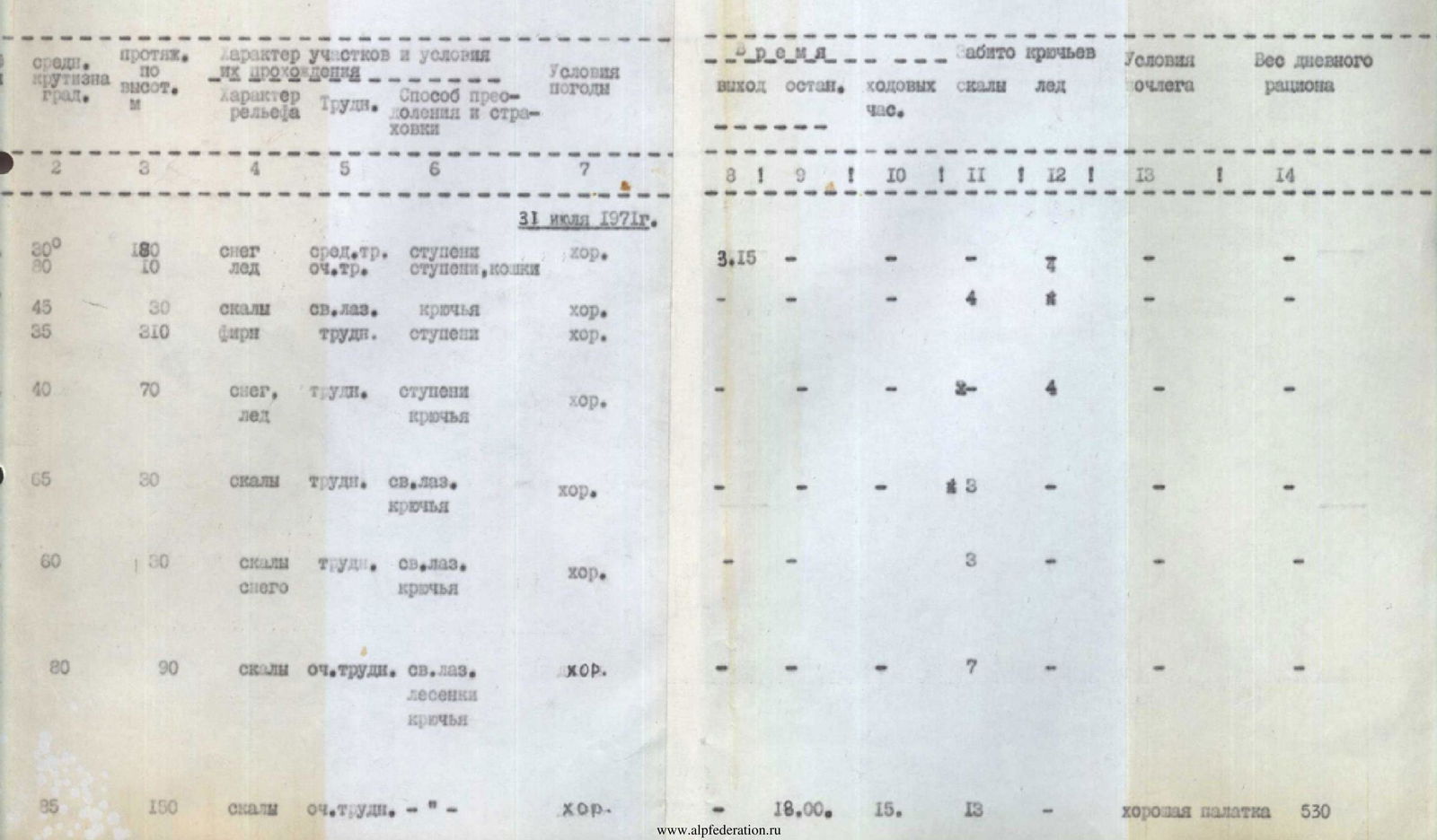
Date of ascent (Year, month, day) — August 3, 1971.
Route Description
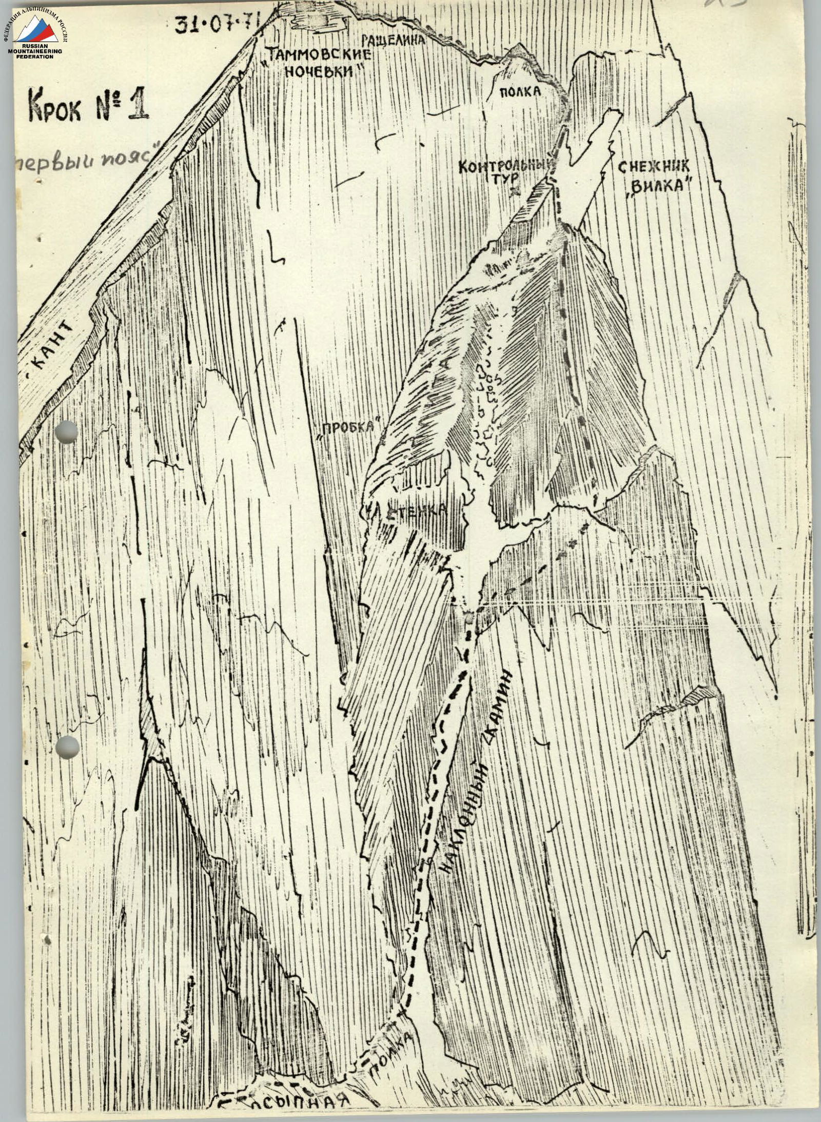
Day 1. July 31. To the left of the rocky island and avalanche groove, two bergschrunds are overcome on the avalanche cone. Further, along the snow-ice slope, the steepness of which gradually increases. Movement towards the rocky island and, bypassing it to the left along the visible path along the slope of 40–45°, exit under the first wall. The wall is bypassed from right to left along the snow-ice slope with an exit to a snowy ridge. Along the snowy ridge, turning into an ice slope, bending around the lower part of the wall from the right, we rise 30 m to an ice isthmus with a steepness of 40–45°. From the isthmus, a traverse to the left and upwards 40–45 m to a snowy shoulder under the first wall.
Further along narrow shelves on the slabs 30 m to a small isthmus to the right and upwards. From the isthmus, 25 m upwards leads to a corner. Insurance is with pitons and through ledges. It is necessary to drive in pitons to create artificial footholds.
Upwards along the corner, the rocks are covered with ice and snow. In the middle of the corner, there is a ledge on which a loop can be thrown for insurance. The inner corner turns into a chimney covered with ice (30–40 m). Ahead is the key point of the 1st day — a chimney turning into a crevice. It is impossible to pull out backpacks here, and despite very difficult climbing, one has to go with backpacks (Fig. 1).
We move along the right rocky wall of the gully. Further, the gully turns into a 15 m chimney 40–45°. Along the chimney, we move into a crevice, which goes to the left and upwards at an angle of 35–40°. After 5–7 m, the crevice comes out onto a group of sharp rocks, from where we move, bending around a large protruding rock from the right. Climbing is extremely difficult. Insurance is only on pitons. Often one has to sprawl on the slabs to their full length or, using a rope, pendulum, move from one foothold to another. The backpack is very hindering, but it cannot be left behind. Having bypassed a smooth plug from the right, we exit onto an inclined slab. Along the inclined slab of double slope, we move towards a small step in front of a wall going up 10 m. Above the step by 1 m — a narrow shelf running to the left from the corner formed by 2-meter walls. Along the shelf to the left for 3 m. Further along an inconspicuous gap for 4–5 m. At 1.5 m on the wall framing the slab on the left, a sharp stone protrudes. From it upwards to the right to the cornice in the wall, further to the protruding stone and through 3–4 m — to a narrow shelf going up along the wall. On the shelf is a control cairn. (Passage of the section — 3 hours). Further movement along the rocky shelf with ice with a steepness of 35° to a snowy slope (bivouac is possible). Straight up under 80° a "reddish" monolithic wall goes up, turning to the right into a semblance of a ridge, behind which a black ridge of rocks is visible, steeply going up.
To the left along the wall, a crevice goes up, turning into a chimney. Organizing insurance for ledges, movement along the crevice to the protruding stone — 8–10 m.
Further, the gap turns into a vertical chimney with a stone plug in the middle, which is bypassed on the left along the wall. Above the plug, at three meters, there is a ledge through which insurance is possible.
In the upper part, the chimney turns into an ice gully with protruding stones. Further:
- along the shelf in the direction of the large yellow stone;
- from the stone to the right along the shelf with a steepness of 45° — 30 m upwards.
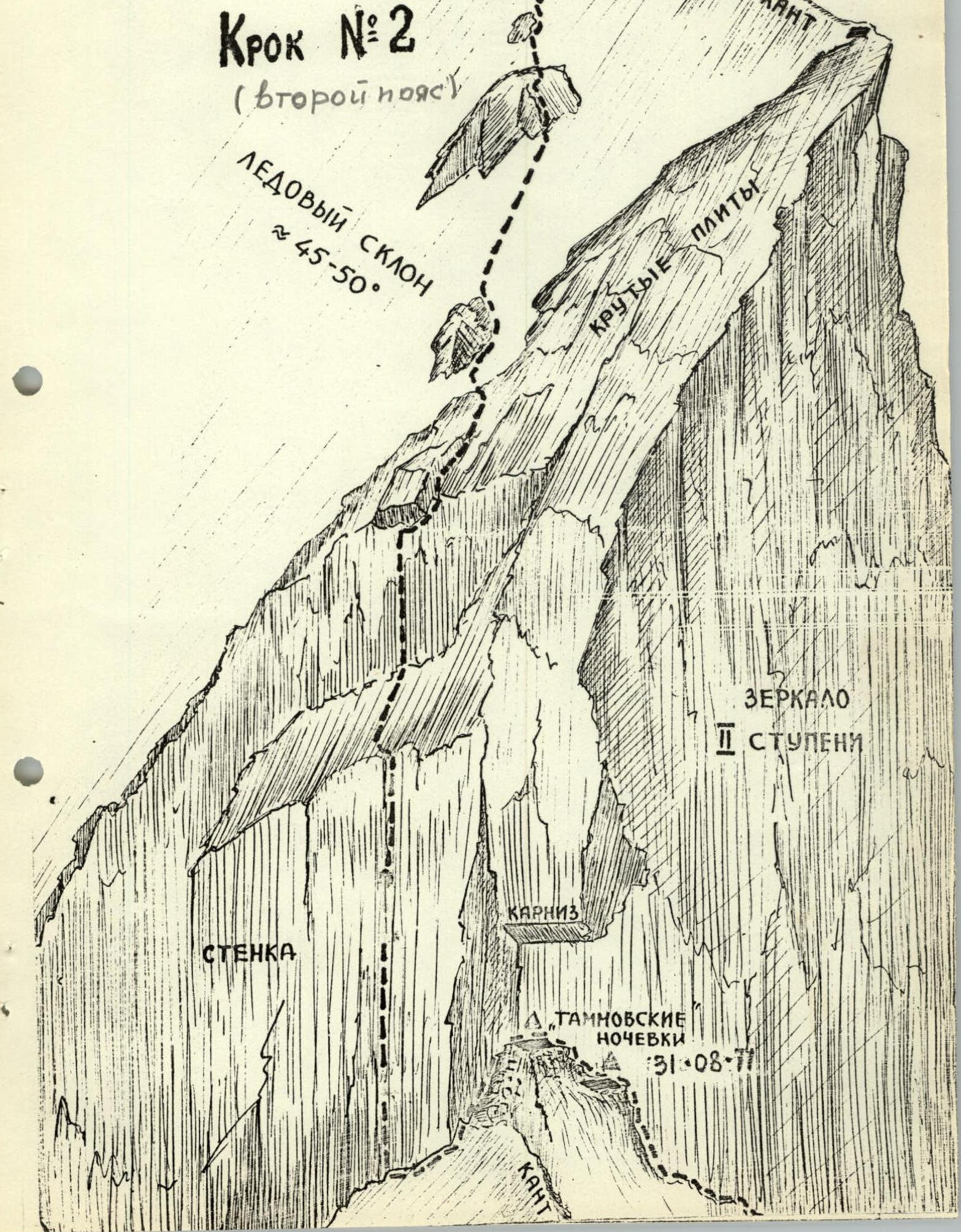
At the end of the shelf — a 4 m wall leading to the ridge-edge of the wall (overnight stay).
Further:
- first upwards under the overhanging stone — 10 m;
- then traverse to the left to the chimney — 15 m.
The bed of the chimney is filled with ice. We exit onto a wall 50° and along the wall to the couloir — 30 m, further along its left side upwards, cutting steps in the ice and clearing the left wall to find footholds and a place to drive in pitons.
Approximately from the middle of the couloir to the right, a semblance of a shelf departs, at the end of which you can easily organize an overnight stay.
(Working time — 15:00).
Day 2. August 1.
The path goes up the couloir to the crevice, from here 7 m to a pile of stones forming a semblance of a ridge in the snow-ice slope under the second wall.
Along the crevice, it approaches the snow-ice slope with a length of 10 m, a steepness of 35°, with individual stones embedded.
Further, the wall goes up almost vertically. No cracks or ledges are visible. From the site (apparently, the overnight stay of the Tamm or Chunovkin group), traverse to the left downwards, and below two rows of pitons without a ladder, very carefully we go traverse to a large detached stone. Climbing is extremely difficult.
From the upper part of the dump, it is somewhat easier, since an winding crack has appeared, into which three channel pitons are driven one after another.
Further:
- move along the ice-filled shift in the wall, climbing is very difficult;
- 9 pitons are driven in for 20 m;
- another 40 m of climbing with cutting steps and hanging two ladders, and a smoothed corner (shift) leads to a shelf.
Further along the shelf to the slabs covered with snow and ice, to the "rusty" rocks. 30 m, pitons are driven in, a place is organized for lifting backpacks.
Further along the snow-ice slope, having previously overcome the snow-covered slabs, with a steepness of 40–45°. The length of the slope is 150 m. It is passed obliquely to the right, bypassing the rocky island (20 m). Leaving the island on the left, along a 45-degree slope — an exit to the isthmus. (Platform for overnight stay. A total of 11 climbing hours were spent).
Day 3. August 2.
At first, straight up along the spur of the walls, something like a snow-ice ridge with steep rocky areas, where one has to climb with maximum effort.
Further:
- to the left upwards in the direction of a large overhanging stone;
- bypassing it from the left along the path;
- into an ice couloir with a smooth ice forehead.
It is necessary to cross twice, both times stretching out in a split and hanging on pitons. We pull out backpacks.
Further upwards 25 m under the wall with a steepness of 40–50°, at first snow-ice, and then rocky.
To the right, below the ridge — a site with an overhanging wall on the left.
Overnight stay. Total time spent — 9 hours.
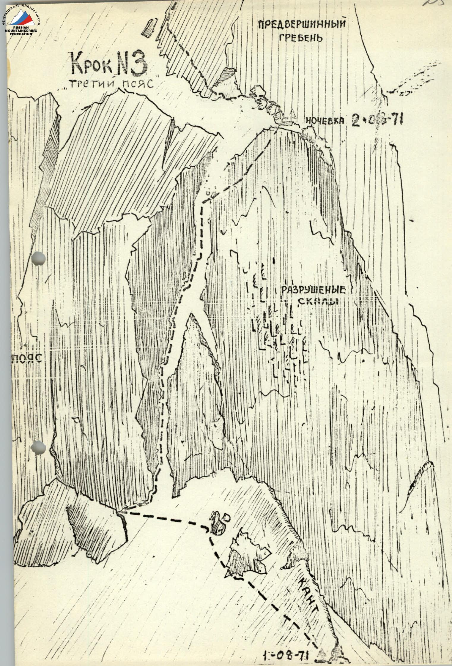
Day 4, August 3. Climbing is difficult and very unpleasant, since every foothold has to be cut out of the ice. From the overnight stay upwards to the ridge along steep rocks 30 m, along a 50° ridge-slope to the wall, along a chimney 70° 5 m along the right wall traverse to the left. Another 4–5 m we approach the overhanging stone under the left wall. A detour along the steep ice to the right to the inflection, which leads through 2 m to a three-meter ice ridge resting against the wall. To the left of the chimney, a detour around the wall. Traverse along the wall to the left, we cross the section of the wall above the chimney, which ends here. Movement in the direction of lowering the wall. A few meters upwards along difficult rocks and exit to the lowering. Movement upwards from one ledge to another. Then to the left upwards, a transition to the next ridge of rocks. After 30 m, smooth slabs. At 25 m, 3 rock and 3 ice pitons are driven in, ladders. Steepness 60°. After 35 m, we approach a rocky ridge, which on the left along the path forms a 15–20 m rocky shift. It shows a gap leading to the top of the ridge. 3 m along the steep ice to the detached stone and along it to the rocky shift. To the left and upwards in the direction of the gap. The gap leads to a rocky ridge 50–55°. After 30 m, two rocky islands are overcome.
Above is a slope. After 40–50 m — an exit to the inflection of the slope. To the right is a narrow, short (~10 cm) snowy ridge with steep slopes. To the left is a 10 m isthmus. Overnight stay is possible.
Further:
- along a 10 m snowy isthmus to a 30 m wall 65°;
- on a slab upwards for 3 m;
- then traverse to the left to the "forehead" of the ledge 2.5 m and further to the protruding stone;
- traverse from the right upwards for 7 m to a ledge, from which to the inflection of the wall.
Under 45° upwards, a group of rocky islands with snow-ice isthmuses goes up.
- The first island along the edge of ice and rocks: 20 m upwards, then traverse to the left.
- Further to the right: along the ice 5–6 m, then upwards along the ridge of rocks for 20 m to a snowy isthmus.
- 30 m along the isthmus to a large stone.
- From it to the right and upwards to a vertical slab with a height of 5–6 m.
- The slab is passed head-on and leads to a snowy slope.
From here, the main ridge of Krumkol is visible.
Above the slab under 35° upwards, a snowy slope goes up. After 70–80 m, we approach an inner corner. Its base is ice 35°, higher — up to 50°; in the middle, and then to the left, a 20 m rise upwards.
Then:
- to the left along the rocks;
- onto a snowy slope;
- after 30 m — an exit to the ridge of Krumkol.
Overnight stay. Total time spent — 13 hours 30 minutes.
Day 5. August 4. Along the snowy ridge, having overcome two gendarmes, in 2.5 hours we reach the summit. Descent along the route 3B cat. sl. to the Krumkol glacier.
General Characteristics and Recommendations for the Route
The north wall of Krumkol is a slope with an overall steepness of about 60° and a length of about 1680 m.
The route is logical and diverse in terms of relief forms, includes rocky and ice cliffs, and snow-ice slopes.
This route is complex throughout and requires climbers to have the entire arsenal of mountaineering techniques. The snow-ice section at the beginning turns into:
- couloirs and slabs filled with ice;
- small sections of a snow-ice ridge;
- a sheer hundred-meter wall;
- again slabs — dry and snow-covered, covered with a crust of ice or filled with water (especially in the lower part);
- again chimneys, couloirs, ice.
The overall steepness is about 60°, but many sections are close to sheer. Significant difficulties when passing the wall are created by ice on the slab-like sections of the route, which clogs all cracks, making climbing and insurance difficult.
However, almost the entire route is passed by pure climbing, which increases its mountaineering value.
The route requires good physical and moral-volitional preparation and can be recommended to a strong group that works equally well on snow, ice, and rocks.
There are rockfall-prone areas on the route (above the "Tammovskie" overnight stays after 10:00), which require increased attention.
Given the need for a large number of pitons, carabiners, and ladders, it is advisable to have lightweight equipment on the route.
Due to frequent rockfalls from the southern slopes of Krumkol, movement along the glacier on the descent must begin as early as possible. According to the unanimous opinion of the group, its difficulty goes beyond the usual concepts of 5B cat. sl.
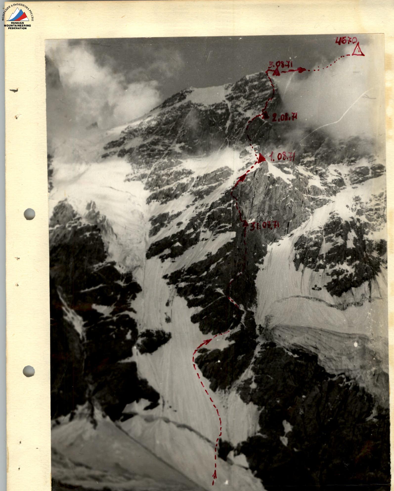 Krumkol — — — path of ascent of the group
Table of Main Characteristics of the Ascent Route to Krumkol Peak via the North Wall (4676 m).
Height difference of the route — 1680 m, including the most difficult sections:
- rocky — 320 m;
- ice — 140 m.
Average steepness of the route — 61°, including the most difficult sections:
- rocky — 86°;
- ice — 65°.
August 1, 1971.
70 50 Rocks difficult free clim. 8:00. 9 pitons 85 40 Rocks difficult — «» — 19:00. 11 11 19:00. 11 good tent 550
August 2, 1971.
90 10 — «» — Very difficult climber «» — 8:00. 8 pitons 85 50 — «» — Very difficult — «» — 20 pitons 75 10 — «» — difficult free clim. 4 pitons 45 70 Rocks, snow 17:00. 8 1 ice 70 difficult ice 70 difficult rope 8 1 pitons 30 20 snow, ice 17:00. 9 good tent 550
August 3, 1971.
40 30 ice, rocks — «» — 8:00. 4–5 ice screws 8:00. 4–5 pitons 75 48 ice Very difficult rope 15 2 pitons 75 2 ice Very difficult — «» — 2–3
Croquis №3