-
Technical category.
-
Caucasus, Mizhirgi gorge.
-
V. Krumkol 4676 m, via the North Face.
-
Suggested route - 6A category of difficulty, first ascent.
-
Route characteristics: height difference: 1585 m. length: 1956 m. length of sections with 5–6 category of difficulty: 399 m, out of which 6 category - 113 m. Average steepness of the rock bastion 70°.
-
Pitons hammered in: Rock: 94/28 Friends: 16 Nuts: 76/25 Ice screws: 120
-
Team's total climbing hours - 25, days - 3
-
Overnights: 1st without a tent (three half-lying, two - sitting on rock shelves) 2nd - in a tent, on a snow-ice ridge
-
Team leader: Grygortsiv Andrey Vasilyevich, Candidate Master of Sports Team members:
- Cherenkov Alexander Stanislavovich, Candidate Master of Sports
- Pachkovsky Pavel Antonovich, Candidate Master of Sports
- Panchenko Viktor Mikhailovich, Candidate Master of Sports
- Orlov Valery Grigoryevich, Candidate Master of Sports
-
Coach: Shortov Yuri Ivanovich, Master of Sports
-
Departure to the route: July 16, 1988, 4:00 Summit: July 18, 1988, 10:00 Return: July 20, 1988, 13:30
-
Organization: AUSB "Bezengi"
Team's tactical actions. The tactical plan for the ascent was based on:
- good knowledge of the area,
- its weather conditions,
- the state of the route,
- the capabilities of each participant and the team as a whole. Particular attention was paid to ensuring safety measures.
All team members have visited the Bezengi area multiple times, both as athletes and as instructors at the alpine base, and have repeatedly made ascents of 5B category of difficulty.
The tactical plan consisted of two parts:
- traversing snow-ice sections of great length and steepness
- overcoming vertical, ice-filled walls and chimneys in the center of the bastion, about 400 m long.
To traverse the ice sections, all team members were equipped with twelve-tooth crampons. Ice screws were shortened, large diameter - for flow ice and ice screws with a diameter of 20 mm - for porous ice. To overcome the ice-filled walls of the bastion, ice axes, skyhooks, and friends were used.
Features of the ascent:
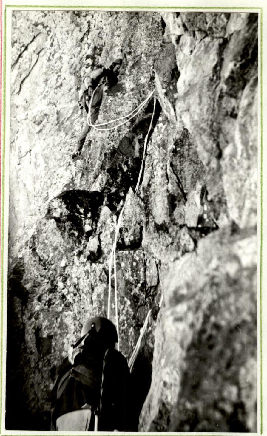
- The first climber had to traverse a large part of the bastion using artificial aids (AIDs), employing numerous diverse protection elements and pitons.
- The first climber constantly worked using "krjukonogi" (a type of aid), which significantly accelerated their progress.
- The first climber on the bastion worked only on a double rope.
- The remaining participants worked on the fixed ropes using two jumar clamps, which facilitated their quick and safe progress.
Organization of fixed ropes (belay stations):
- All fixed ropes were blocked on 3-4 anchor points.
- Whenever possible, the fixed ropes were positioned under the cover of rocks and slightly to the side of the line of movement.
Throughout the entire ascent, the participants did not suffer a single injury.
All participants had pocket food in their backpacks, allowing them to work throughout the day without gathering.
The first overnight stay was arranged in the upper part of the bastion under the cover of cornices. The participants were accommodated on three shelves in a semi-reclining position.
The second comfortable (lying down) overnight stay was located under a rock on the shoulder of the counterfort.
The tactical plan for the ascent was largely followed. There were no deviations from the planned route.
Route diagram in UIAA symbols to the summit of Krumkol via the North Face.
Pitons hammered in:
- rock: 94/28
- nuts: 76/25
- friends: 16
- ice screws: 120 Climbing days - 3, hours - 25.
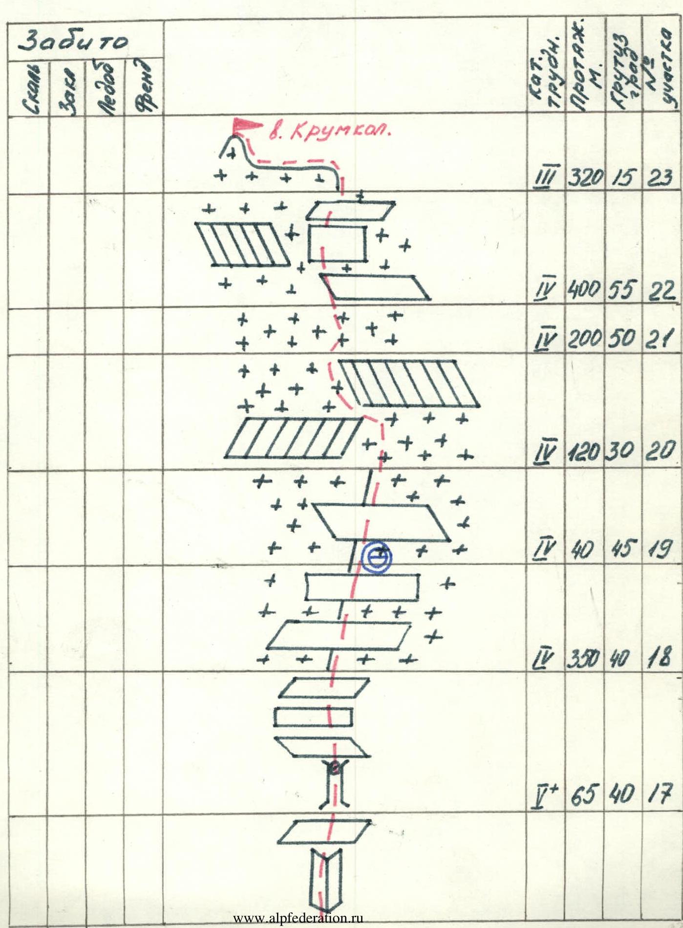
| Rock | Nuts | Ice | Friends | Cat. diff. | Length, m | Steepness | Section # |
|---|---|---|---|---|---|---|---|
| 14 | 9 | 4 | 5+ | 76 | 60 | 16 | |
| 4 | 9 | 5 | 36 | 60 | 15 | ||
| 8 | 4 | 1 | 3 | 5+ | 34 | 70 | 14 |
| 3 | 8 | 5–1 | 26 | 60 | 13 | ||
| 1 | 1 | 2 | 4 3 | 3 | 92 | 12 | |
| 4 | 1 | 5 | 8 | 75 | 11 | ||
| 6 | 4 | 2 | 3 5 | 22 | 70 | 10 | |
| 5 | 1 | 5+ | 15 | 65 | 9 | ||
| 8 | 5 | 1 | 2 5+ | 22 | 75 | 8 | |
| 5 | 2 | 2 5 | 15 | 70 | 7 | ||
| 3 | 8 | 1 | 5 | 20 | 75 | 6 | |
| 1 | 2 | 1 5 | 8 | 90 | 5 | ||
| 2 | 2 | 5+ | 10 | 85 | 4 | ||
| 6 | 6 | 2 5 | 30 | 90 | 3 | ||
| 5 | 3 | 1 | 3 5 | 12 | 90 | 2 | |
| 3 | 1 | 23 | 4 | 350 | 55 | 1 | |
| 3 | 3 | 150 | 40 | 0 |
Route description by sections
Section 0–1
From the glacier to the bergschrund along a snow-ice slope in the direction of the snow bridge.
Section 1–2
Along the ice slope with increasing steepness, reaching 60° at the base of the counterfort. Protection via ice screws, alternating movement. We approach the base of the counterfort to the left of the rock "paw".
Section 2–4
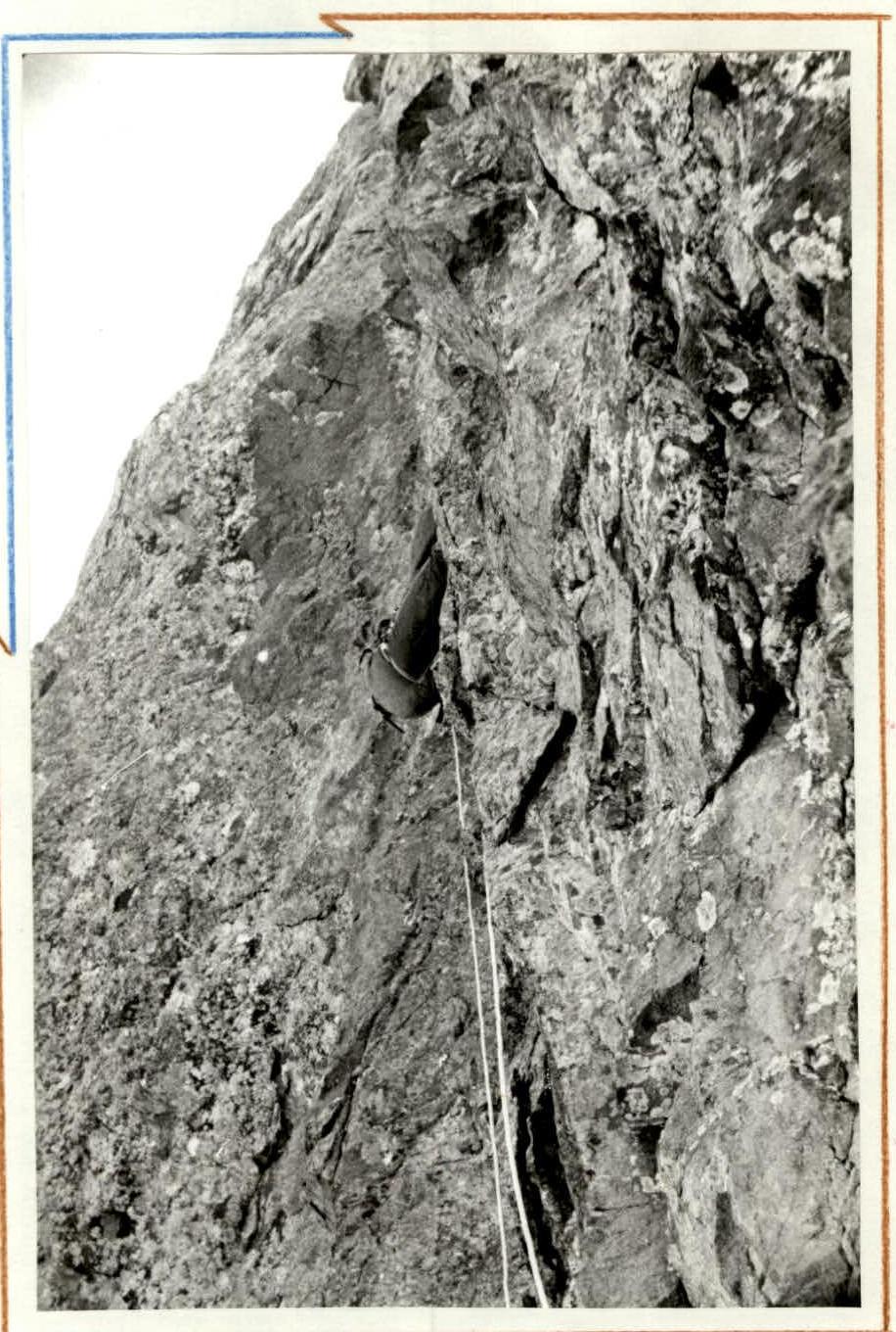
Along the shelf to the left under the base of the oblique double chimney. In the chimney, the upper part is filled with ice, forming a waterfall at the bottom. The lower part is traversed to the left with a gradual traverse to the right under the overhanging part. Overcome with the help of AIDs about 12 m. To the right, transition to the right edge of the chimney, along it through a rock cornice exit to the left onto a shelf, where it is possible to organize a safe change of lead. The entire rope is traversed using AIDs.
Section 4–7
From the shelf along the wall upwards 10 m under the base of the ice-filled chimney with a plug. Large icicles hang from the plug, which need to be chopped off. Lateral cracks and walls are filled with ice. Two ice screws are screwed in, and with the help of ice axes, the plug area is traversed. To the right, behind the plug, is a wet wall of the chimney, partially clear of ice, where many nuts are placed. This 20 m wall leads to a ridge, where it is safe to organize protection.
Section 7–9
From the rib along the right wall of the internal angle (nuts and friends go well) exit onto a small shelf. Ahead is a smooth slab without cracks, where skyhooks were very useful, otherwise it would have been necessary to use bolt hangers. The slab rests against a small overhanging cornice. The cornice is overcome directly head-on, as on both sides there is again much flow ice. Behind the cornice is a small wall, along it straight up, on a shelf - a belay station.
Section 9–11
Along a steep gully with flow ice, we exit along its right wall. Overcome a cornice, exit onto a shelf. From the shelf along the wall, bypassing to the left of a large cornice in the direction of black rocks with small icefalls, we exit onto a series of shelves, where it is possible to arrange an overnight stay.
Section 11–14
From the overnight stay, traverse to the left along a shelf onto a wall under an overhanging part of a cornice with a series of cracks. The cornice is traversed with the help of AIDs (nuts, friends). The wall is clean and traversed by the first climber in crampons. After the cornice, pleasant clean climbing along the wall, then along the ridge to a connecting ridge. (The rope was treated.)
Section 14–15. This rope was processed similarly to the previous one. From the connecting ridge:
- along an ice gully in crampons (they were not removed until the summit) 20 m,
- with an exit to its right part,
- along the ridge straight up.
Section 15–16
In this place, the counterfort gradually becomes less steep, climbing becomes less difficult. Almost everything is traversed by free climbing without the use of AIDs. We continue to move straight up along the ridge with a transition into an internal angle, interrupted by a shelf. Further along the chimney to a convenient shelf for protection.
Section 16–17
This section of the route is a series of small walls, shelves, and internal angles filled with ice, formed by a large internal angle, almost ending at the summit of the bastion.
Section 17–18
The exit to the bastion is blocked by a wall, which is traversed along an ice-filled vertical chimney with a plug in the upper part. Further - a series of shelves that lead to the shoulder of the bastion.
Section 18–19
This is the shoulder of the bastion up to the icefall in its upper part. It represents a 300-350 m section of an ice-snow slope, interrupted by a series of rock islands. The overall steepness reaches up to 45°. Protection is provided via ice screws, and in places where rocks outcrop - via nuts and rock pitons.
Section 19–20
At the end of the shoulder - an overnight stay. The camping spot is safe from the overhanging icefall above, protected by a rock island. We traverse a snow-ice slope with a steepness of 45° around a rock island and exit directly under the icefall.
Section 20–21
The icefall is traversed between its upper part and a detached huge serac. Along "bridges" formed during the break. Protection is provided via ice screws screwed directly into the walls of the icefall.
Section 21–22
Behind the icefall - a snow-ice section with a steepness of up to 45-50°, ending in a bergschrund.
Section 22–23
In fact, this is the last technically difficult section of the route. An ice slope between the upper rock part of the counterfort and the upper ice slopes of the main ridge of the Krumkol massif. It represents an ice slope with a steepness of up to 50° in places, interrupted by rock islands. Its length is about 400 m. The section ends with an exit onto a snow ridge.
Section 23–24
The main snow ridge leads to the summit.
Traverse on section 2–3
Section 13–14