I. Group Composition
The ascent was made by a group from the LОС DSO "TRUD" with the following composition:
-
- VASILYEV B.P. — team leader, 1st sports category
-
- ROMANENKO N.P. — participant, 1st sports category
-
- SOLONNIKOV V.A. — participant, Candidate for Master of Sports
-
- ZHITENEV F.N. — participant, 1st sports category
-
- BERGILESSOV F.V. — participant, 1st sports category
-
- MYASNIKOV V.S. — participant, 1st sports category
This composition was planned according to the application, and during the preparation and execution of the ascent, it remained unchanged.
II. Brief Geographical Description and Sporting Characteristics of the Route
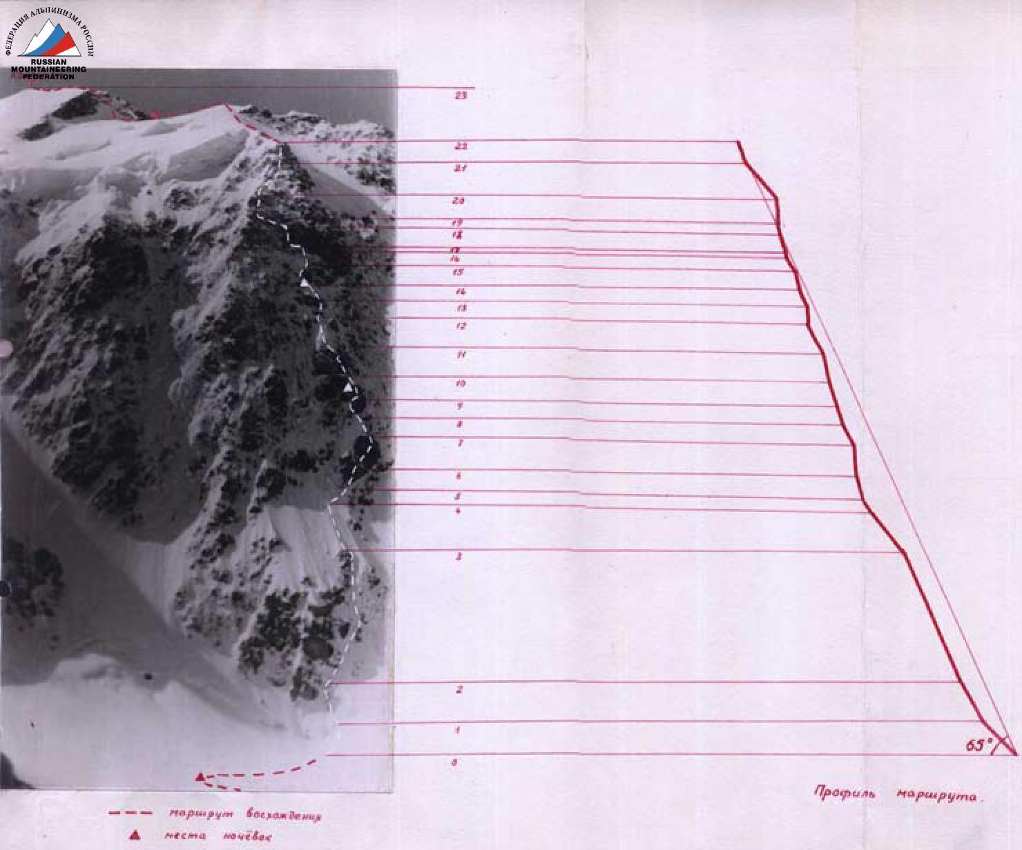
The peak Koshtan-Tau (5154 m) is one of the six five-thousanders of the Caucasus, located in the Bezengi region. It is the fourth highest peak in the Caucasus after Elbrus, Dykh-Tau, and Shkhara. It closes the "horseshoe" of Dykh-Tau–Koshtan-Tau. Several routes have been laid out from the Kun-dom-Mizirgi glacier to the summit. The most challenging of these are the routes up the northwest wall. The wall is divided into two parts. The right part of the wall, in turn, consists of counterforts. The left counterfort was traversed in 1962 by a Moscow group led by A. Simonik (silver medals at the USSR Alpine Championship). The steeper right counterfort remained untraversed. The route is characterized by a wall with an altitude difference of over 800 m and a steepness of more than 60°. The rocks are iced and snow-covered. There are no places for bivouacs.
III. Brief Description of Climbing Conditions in the Bezengi Region
Climbing conditions in Bezengi differ significantly from those in other Caucasus regions. These differences are primarily related to the greater height of the region's peaks and the larger amount of ice and snow on the routes. All walls in the region facing north and northwest are covered in ice and snow. The approach to many routes is hindered by the need to overcome vast icefalls. For example, to approach the northwest wall of Koshtan-Tau, one must traverse four steps of the Kun-dom-Mikirgi icefall. The difficulties of ascents are compounded by the extremely unstable weather in the region.
IV. Preparation for the Ascent
The group members have been making ascents in the Bezengi region over the past five years. During this time, they have traversed routes such as:
- Krumkol via the "mirrors",
- Dykh-Tau via the north wall,
- Shkhara via the northeast wall,
- Mizirgi via the north ridge,
- and others.
The group members ascended the peak Koshtan-Tau via the north ridge, following the path of Kalishevsky, and traversed p.Tikhonov–Koshtan-Tau. During these ascents, they observed the possibility of ascending via the northwest wall. This year, the group members underwent an extensive preparatory period, followed by a series of training ascents. They received detailed advice on the terrain and climbing conditions from the members of Simonik's group.
V. Tactical Plan for the Ascent
Considering the good physical and technical preparation of the participants, the group planned to complete the route from the glacier to the summit in three days, and although the route was in a challenging condition (a large amount of ice and snow on the rocks) and the complexity of the route turned out to be somewhat greater than expected, the group managed to adhere to the planned schedule.
Since it was known that only seated bivouacs were possible on the route, it was decided not only to approach the wall on the first day but also to process the lower part of the route. When traversing the route, special attention was paid to the coordination of the rope teams and the timely change of the lead climber.
It is worth noting that the first climber proceeded with a lightened backpack, and some sections were climbed without a backpack.
The group had at their disposal equipment such as:
- three- and two-rung ladders (15 pieces in total),
- a large set of pitons (steel, duralumin, and titanium),
- titanium wedges,
- titanium and screw ice pitons,
- drill pitons and drills,
- rope clamps for ascending.
All this allowed minimizing the number of sections where rope hauling was necessary.
VI. Order of Route Traversal
Day 1, August 6, 1966. Departure from the Bezengi alpine camp at 7:00 and ascent to the third step of the Kun-dom-Mizirgi icefall by 13:00. The icefall is heavily crevassed. Movement in crampons. Two ice pitons are driven in. 15:00–16:00 — traversing the fourth step of the icefall and reaching the plateau under the wall. 16:00–20:00 — a rope team processes sections R1 and R2 of the route.
Section R1 — a steep snowfield (3 ropes).
Section R2 — overcoming the bergschrund, the upper edge of which overhangs, and then moving up steep ice (60°) to the base of the rock belt — the section is traversed in crampons, with steps cut during the bergschrund crossing and an ice piton used as an anchor point. Further up the ice on front points — two ropes (4 ice and 1 rock piton). Two ropes are hung on section R2.
Day 2, August 7, 1966. Departure at 3:30. 1.5 hours are spent traversing sections R1 and R2.
Next — steep ice with sections of vertical rock (section R3). Rocks on the left overhang. 6 ropes. Movement on front points is very challenging, often requiring step cutting. In some places, there is steep natty ice, necessitating the use of screw ice pitons as anchor points. 5 hours are spent traversing this section. 18 ice and 5 rock pitons are driven in. Further — more gentle ice, 3 ropes (section R4). In the lower part, the ice is covered with a thin layer of frozen but crumbling snow under crampons. The last 15 m — natty ice. 5 pitons are driven in on this section. 1.5 hours are spent traversing it.
Further movement upwards is complicated — steep natty ice. It is necessary to traverse rightwards across natty ice under the rocks (section R5). The traverse is challenging, with 2 ice and 1 rock piton.
Sections R6–R7 — overcoming a wall. Rocks are iced.
- Section R6 — traverse across slabs and then across protruding iced rocks — 1 rope (2 pitons).
- The path goes rightwards up a vaguely defined ledge, 1 rope (section R7).
- Then another 10 m rightwards under an overhanging wall across slabs.
From here — exit into a vertical rock angle and up it. In the upper part of the angle and during the traverse, pitons are used as anchor points, and a ladder is hung to exit the angle (5 rock pitons are driven in). Traversing sections R5–R7 takes 3 hours 30 minutes.
Section R8 — steep natty ice (3 ice pitons).
Further:
- Leftwards up an iced internal angle — 20 m (3 pitons).
- Then rightwards up — traverse under overhanging rocks towards a small iced ledge (another 2 pitons — very challenging climbing) (section R9).
The only path further is overcoming a small (1 m) cornice and then up steep rocks to a section of ice. Ladders are hung to overcome the cornice. It is necessary to haul backpacks, with 5 pitons driven in. 5 hours are spent overcoming sections R9 and half of R10.
Here, a place for a seated bivouac is cut into the ice — a narrow ledge 3 m long and 40–50 cm wide on a steep ice slope. On the same day, another 15 m upwards across slabs is traversed, and a rope is left on this section.
Day 3, August 8, 1966. Departure at 7:00. 2 ropes of very challenging climbing (section R11). Steep rocks. Initially, 15 m up a wall with small iced holds (3 pitons). Then another 20 m (3 pitons) and up an angle exiting onto an iced inclined ledge and further up rocks resembling slabs (3 pitons). When overcoming the wall and angle, pitons are used as anchor points. 3 hours are spent traversing this section. The further path — up steep natty ice (crampons are put back on) 2 ropes under a rock protruding from the ice and rightwards up onto an inclined ice ledge under an overhanging wall, which is bypassed on the right via an ice groove. 6 ice and 4 rock pitons are driven in on this section. 2 hours are spent traversing it (section R12). The path upwards goes up iced vertical rocks (15 m) under the base of a rock (10 m) with an overhanging "plug" (section R13). Holds need to be cleaned with a hammer, as in many previous places. The "plug" is bypassed on the right. This involves overcoming a small (1 m) cornice with the help of ladders. Pitons are repeatedly used as anchor points. 7 rock and 1 ice piton are driven in on this section. 2 hours are spent traversing it.
Upwards, an ice slope ascends (section R14), 3 pitons. Here, under rocks near a small protruding stone, a bivouac is cut into the ice. This is an ice ledge 1 m 20 cm wide and 3 m long — a seated but fairly comfortable bivouac. To cut out this ledge, a layer of ice more than 2 m thick had to be removed on a very steep slope. Organizing the bivouac takes more than 4 hours. During this time, another rope of the further path is processed (section R15) — this is a path leftwards along the ledge (inclined ice — 70°, 10 m) and then through an overhanging section of rocks exiting onto inclined slabs (9 pitons are driven in, two three-rung ladders are hung). A rope is hung at this spot.
Day 4, August 9, 1966. Departure at 6:00. Movement along the hung rope and then up iced rocks under an overhanging wall (3 pitons, section R16). Further — traverse leftwards under overhanging rocks — very challenging climbing — under the base of a vertical angle, iced, and up it 10 m (4 pitons, section R17). These two sections are traversed in 1.5 hours.
The path upwards goes up the middle of the upper wall. Rocks are monolithic, lacking cracks for pitons, very smooth, and iced. Constantly, holds need to be cleaned with a hammer. Very challenging climbing — 2 ropes, 12 pitons. Pitons are repeatedly used as anchor points. One drill piton is driven in. Ladders are hung twice. 4 hours are spent traversing this section.
The further path upwards requires drill work — rocks overhang and are very smooth. Leftwards, inclined slabs are visible. We traverse leftwards up 1 rope (section R19), 4 pitons. Ladders are used twice, slabs are monolithic and iced.
The path upwards goes up an iced internal angle (2 pitons) under the base of an overhanging wall (12 m). Approach under the wall is made across inclined slabs, then along a crack rightwards 5 m to a crack going upwards, iced, and up it through an overhanging section. On the wall, 5 regular and 1 drill piton are driven in. Ladders are hung 4 times. All pitons are used as anchor points (section R20). 3 hours are spent overcoming this section. Backpacks are hauled.
Section R21 — not very challenging climbing initially across an inclined slab and then across rocks protruding from snow and ice (3 ropes, 3 pitons, 1.5 hours).
Another rope of challenging climbing — up slabs 10 m, then traverse under a cornice 5 m rightwards, and further up through a cornice (0.5 m) and across not very challenging rocks — exit onto a snowy ridge (4 pitons). To traverse the cornice, a ladder is hung, and a piton is used as a hold. This section R22 is traversed in 1.5 hours.
The path upwards goes up a snowy slope — exit onto a "cushion" before the summit. Here, on the plateau, a bivouac is made. The last 5 hours, the group moved in thunderstorm conditions, snowfall, and strong wind.
Day 5, August 10, 1966. Departure at 9:00. Via the usual path — exit onto the summit, on the summit at 10:00, and descent via path 4A cat. sl. (north ridge). By 18:00, the group was on the III step of the Kun-dom-Mikirgi icefall.
Day 6, August 11, 1966. Departure at 8:00. Descent through the icefall (1 ice piton). The group returned to the Bezengi alpine camp by 12:00.
43 hours of climbing time were spent ascending the wall, including 4 hours of route processing. Driven in:
- 42 ice pitons,
- 91 rock pitons,
- 2 drill pitons.
VII. Overall Assessment of the Team's Actions
(Team Leader VASILYEV B.P.)
It is worth noting that the group was sufficiently well-prepared for traversing this route. Despite having 6 members, thanks to the clear work of all participants, the group moved at a speed similar to that of the first rope team almost everywhere. The bivouac conditions were very challenging, but despite this, the group maintained its working capacity and was able to sustain a fairly high tempo throughout the ascent.
VIII. Additional Data on the Route
It should be noted that the route is characterized by a high overall tension: on the entire wall, except for the upper part of the counterfort, there are no easy sections. It requires maximum attentiveness and thorough piton belaying throughout the entire route.
On the route:
- there are no places to set up tents;
- there is no spot where more than 3 people could gather;
- organizing even a seated bivouac poses significant difficulties and requires a substantial expenditure of effort and time.
Certain sections of the route require the application of the highest climbing techniques (ladders, drills, harness work, etc.). The route is combined and very heavily iced. The character of the rocks is very diverse. Monolithic slabs are frequently encountered, and wide cracks are characteristic, so titanium wedges and angle pitons are often used.
In the upper part of the route, there are monolithic sections with very hard rock, making their traversal challenging even with the use of drill pitons.
See captions on the next page.
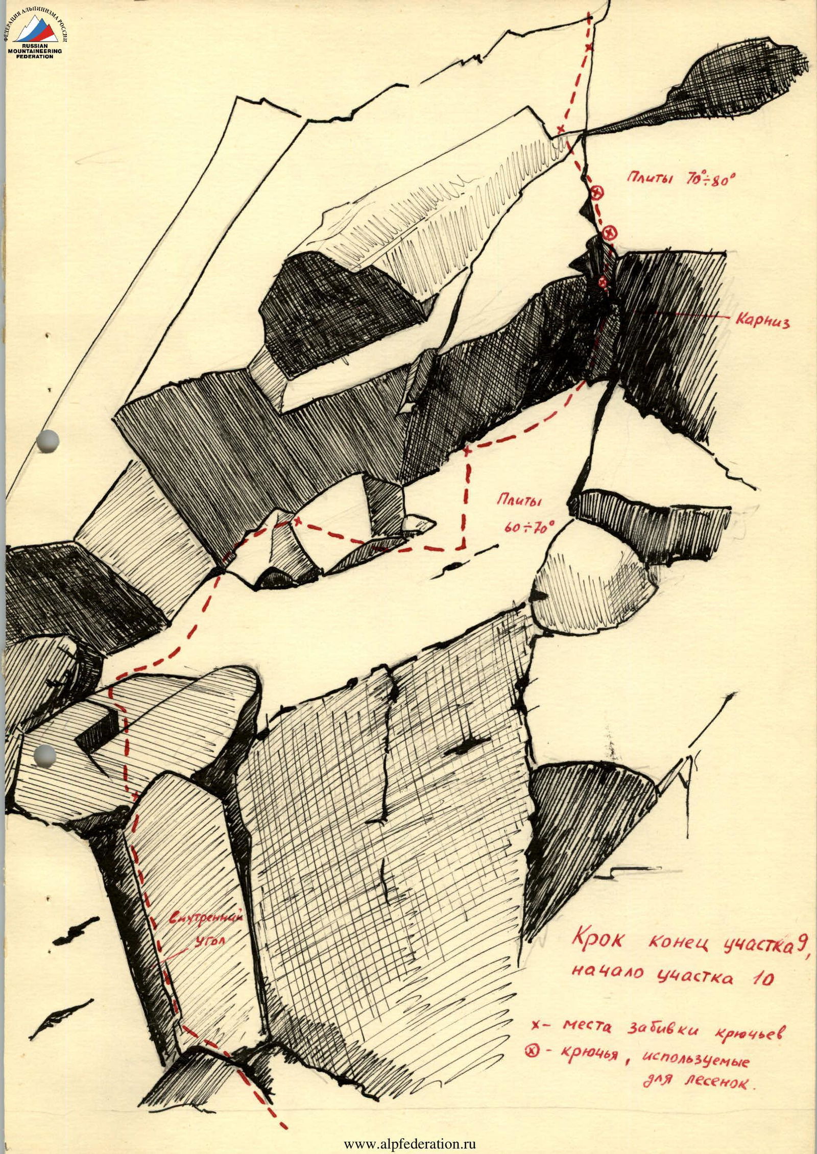 Piton — end of section R9, beginning of section R10
x — places where pitons are driven in
• — pitons used for ladders.
Piton — end of section R9, beginning of section R10
x — places where pitons are driven in
• — pitons used for ladders.
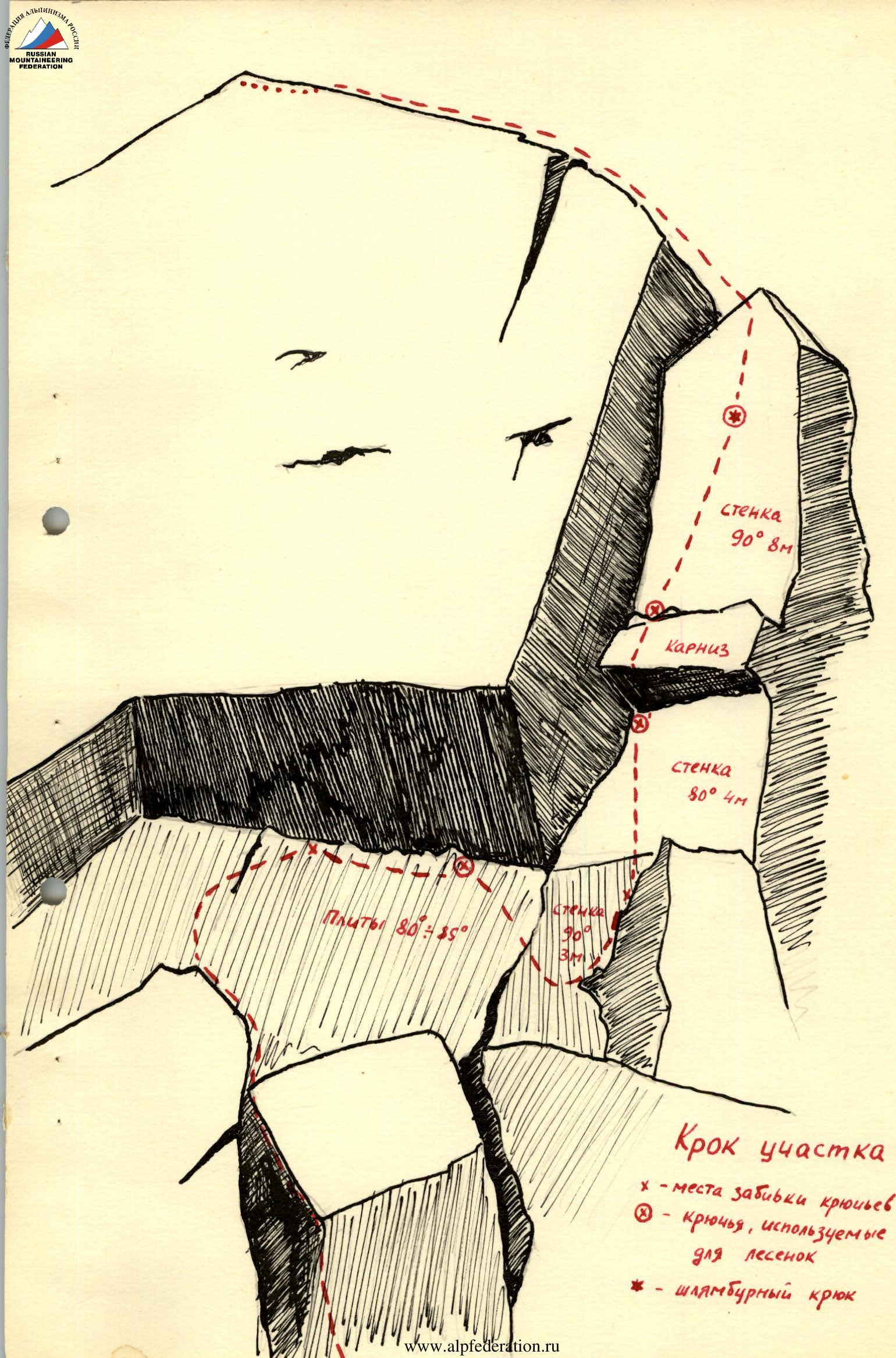 Piton of section R20
x — places where pitons are driven in
• — pitons used for ladders
Piton of section R20
x — places where pitons are driven in
• — pitons used for ladders
- — drill piton