Dedicated to the 40th anniversary of the Communist Party of Ukraine

Report on the Traverse of Koshtan-Tau Massif
Kiev Regional Council DSO "Avangard"
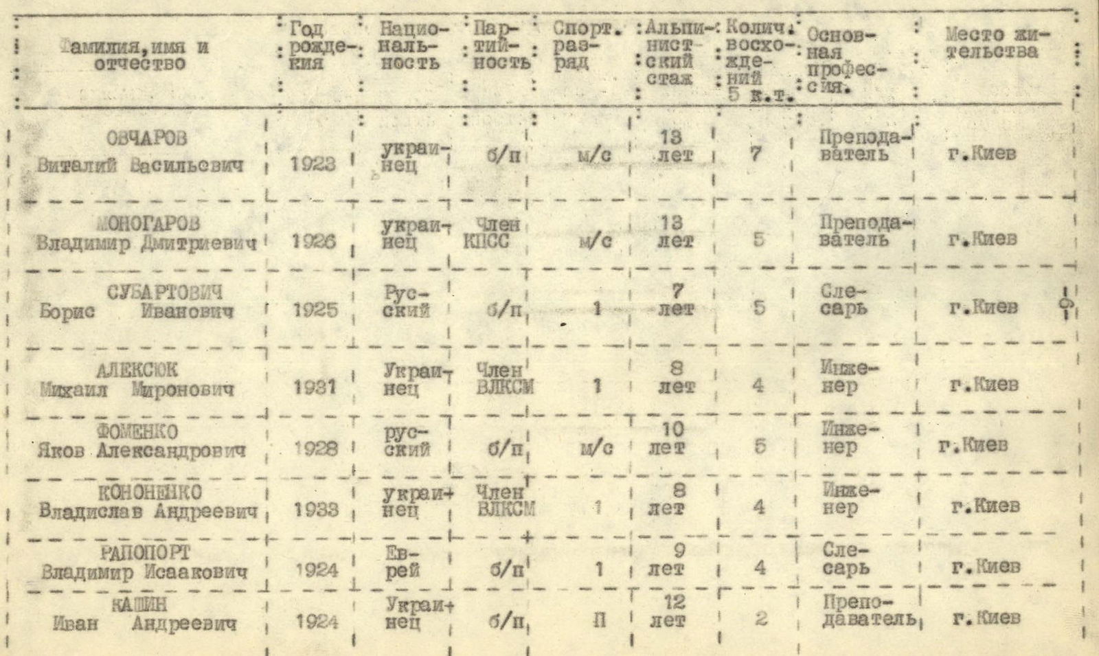
Table 1
Composition of the Assault Group
2. Traverse of Koshtan-Tau Massif
On August 2, the group led by Master of Sports of the USSR Fomenko Ya. A. returned from the northern ridge of Koshtan-Tau, while another group led by Master of Sports Ovcharov V. V., having made a supply drop of equipment and food under the wall of Koshtan-Tau, returned to base camp No. 4. Ovcharov's group did not process the wall due to lack of visibility; the wall was shrouded in fog.
On August 3, Fomenko Ya. A. and Kashin I. A. reconnoitered the lower part of the wall.
On August 4, the auxiliary group returned from the drop, having ascended Koshtan-Tau via the counterfort from the Ullu-auz Glacier.
On August 5, the main group and four observers exited to the foot of the northeast wall of Koshtan-Tau.
The path went along the lateral moraine upwards to the first icefall of the Ullu-auz Glacier, which was bypassed on the right. Initially, the group ascended steep grassy slopes that transitioned into a steep scree leading to the lower large snow plateau of the Ullu-auz Glacier and the northern walls of two separate counterforts of Koshtan-Tau peak.
By skirting the counterforts across the plateau, they exited through the second stage of the icefall onto the upper plateau of Ullu-auz Glacier. The icefall was heavily crevassed, requiring navigation between seracs.
In the upper part of the icefall, they traversed it to the left. After crossing a wide crevasse on a snow bridge, they emerged onto the plateau and set up a bivouac.
The plateau is a basin with a fairly even bottom, dissected by crevasses. Directly in front of them looms the formidable pyramid of the 1.5-kilometer-high northern wall of Koshtan-Tau. Gloomy black rocks rise as a sheer 400-meter wall directly from the plateau.
It was planned to ascend the rocky triangle of the wall in its central part. However, preliminary reconnaissance and observations revealed that it was tactically correct and most expedient to ascend via the right part of the wall triangle. This was due to the excessive rockfall danger in the central part of the triangle, where continuous rockfalls were observed starting from 10:00 AM.
They chose to ascend the right edge of the rocky triangle wall, which represents a steeply inclined, not clearly defined ridge. Rocks either fall to the left down the sheer wall or to the right down a steep ice couloir.
In the upper part of the wall, the route planned by the group before arriving in the mountains coincided with the route refined after reconnaissance.
On August 6, the head of the observer group, A. Galaydyuk, received the radio communication schedule and route details, after which the assault group departed at 5:00 AM.
The weather was good; they proceeded in four pairs:
- V. Ovcharov — V. Monogarov
- B. Subartovich — Ya. Fomenko
- M. Alexyuk — V. Kononenko
- I. Kashin — V. Rapoport.
They began their ascent along a 35-degree snow slope, bypassing a wide bergschrund on the right (R1).
They traversed a snow slope over the bergschrund to the left until the start of the triangle wall (R2).
The first pair to move forward was B. Subartovich and Ya. Fomenko, followed by V. Ovcharov — V. Monogarov, then M. Alexyuk — V. Kononenko, and finally I. Kashin and V. Rapoport.
They crossed the bergschrund on a snow bridge at its narrowest part. After three people had crossed, the bridge collapsed, and the remaining team members ascended a 65-degree, three-meter ice wall, cutting steps (R3).
The area they reached is a rocky outcrop, after which a 41–46-degree ice slope begins (R4 and R5). They donned crampons and drove two ice screws into the slope for protection.
They approached a rock wall, drove an ice screw into a wide crack, and ascended an 18-meter wall with a 5-meter chimney at the top (R6). At the start of the chimney, there is a small rock shelf that can accommodate no more than two people.
They ascended the wall with крючьевой страховкой and self-protection via screws on the rocks.
The wall is made of solid, monolithic dark gray diabase rocks, with a steepness of 75 degrees.
They traversed three meters to the left along the shelf to the base of the chimney, which they ascended using opposition climbing.
After crossing the wall, they encountered another ice slope with a steepness of 53 degrees and a length of 40 meters, flanked on the left by sheer walls and on the right by a steep ice couloir with signs of recent rockfall (R7).
They donned crampons again, with the first climber carrying a lightened backpack.
In the upper part of the ice slope, there is a small section with icing (R8), where they organized protection using screws.
The ice slope leads to a 26-meter, 80-degree rock wall (R9). The granite wall is almost smooth with few handholds. Near the wall, there is on-glacier ice. It is impossible to cut steps; they had to remove their crampons in an awkward position, relying on an in-situ boulder.
They ascended the wall using support aluminum screws, then followed a weakly defined inclined ledge for 7 meters to the left until a wide vertical crack led them to the top of the wall. The wall took 1 hour and 40 minutes to cross.
The weather significantly deteriorated, with fog. At 14:00, V. Kononenko contacted the observers under the wall and reported the group's location by height.
They continued along the ice (10 meters) and then across heavily fragmented rocks (R10).
They approached a chimney with a steepness of up to 70 degrees and a length of 39 meters (R11).
The chimney's structure is notable; the rocks resemble vertically stacked, layered tiles. Climbing requires caution due to the fragile nature of the rock and the risk of it breaking off.
They moved through the chimney with крючьевой страховка and entered a platform where they drove screws.
From the platform, they ascended difficult rocks to reach the ice. The chimney and rock section took 1 hour and 40 minutes to cross.
Along a steep 62-degree ice slope with occasional rocky outcrops, they reached a group of rocks after 40 meters (R12). The страховка was крючьевая on the rocky outcrops. From here, it was possible to exit onto the ridge via the wall, as continuing along the ice slope became dangerous due to rockfall.
The ascent via the wall (R13) onto the ridge was very challenging due to the lack of handholds on the 75–80-degree rocks and falling graupel.
Using aluminum piton screws, they navigated the initial steps and then moved along a narrow ledge, securing themselves every 3–5 meters.
Almost crawling under an overhanging rock awning, they entered a stepped terrace covered in on-glacier ice, where they set up страховка via screws. The section, 36 meters long with a steepness of up to 80 degrees, took the group 2 hours and 30 minutes to cross.
They left a control cairn and a note on the terrace.
Along a short snow ascent, they entered a snow ridge (R14). The страховка was via ice axe. They followed the ridge to a group of rocks and stopped for the night 15 meters below the ridge to the south, at 18:40, at an altitude of 4450 meters above sea level.
On August 7, they departed at 6:10 AM. The weather had not improved; wet snow was falling, and it was completely windless.
They traversed a 35-degree, 80-meter-long snow ridge (R15), a 45-degree, 43-meter-long rocky outcrop (R16), and continued along the ridge with страховка through ledges and screws.
The rocky outcrops alternated with icy sections (R17), followed by a 33-meter, 65-degree rock wall (R18). The wall is a stepped ascent with an overall direction upwards to the right. Movement was hindered by the abundance of freshly fallen snow, requiring them to clear snow and secure handholds.
This section was completed in 50 minutes. After the wall, they traversed a not clearly defined ridge with rock and ice (R19).
They then followed a snow-ice slope that led to a sheer rock wall (R20). The slope is 35 meters long with a steepness of 80 degrees.
By traversing along the wall to the right towards a boulder that closes a small couloir at the foot of the wall, they reached a small platform and organized страховка via screws.
From the platform, a chimney leads upwards to the left, similar to the one previously described, but filled with on-glacier ice and snow.
Using opposition climbing, they ascended the chimney to a flat platform, securing themselves with крючьевая страховка.
They then traversed to the left towards an internal corner with sheer sides.
On one of the internal corner's walls, there is a crack that they used to ascend, employing упорные крючья.
This wall took the group 2 hours and 20 minutes to cross.
Strong gusts of wind began, carrying позёмка along the slope.
Along a complex rock-ice slope with a steepness of 50 degrees and a length of 98 meters (R21), they approached the pre-summit rocky belt.
The time taken to cross this section was 1 hour and 30 minutes.
While the first pairs processed the "belt" route, V. Kononenko contacted the observers to report the group's location, weather conditions, and the climbers' well-being.
The pre-summit belt is a rock wall (R22) with a steepness of 66 degrees and a total length of 61 meters.
The ascent initially goes left upwards through very complex rocks, then right towards a ledge. Midway, they organized крючковая страховка.
Using screws, they entered a vertical crack onto platforms and finally ascended a wall section via a chimney to the last platform before the ice wall of the northern pre-summit ridge.
They gathered as a group, donned crampons, and exited onto the ice from an inclined ledge with крючковая страховка.
A 250-meter ascent along a steep ice slope with a steepness of up to 60 degrees lay ahead.
To the left above, they glimpsed groups of rocks through dense clouds, with large cornices hanging over them. Directly above them, there were also cornices; to the right, a small icefall. They planned their route above it, upwards to the right towards the northern ridge of Koshtan-Tau (R23), where the cornices dissipated.
They had to climb with their front crampon points engaged. Every 10–15 meters, they drove ice screws for страховка and cut out resting places below the screws.
Their movement on the ice was complicated by snowfall. Small avalanches streamed down the ice slope, blown by hurricane-force winds from the pre-summit ridge. On the ridge, there were snow plumes and flags.
The resting places at the screws were filled with snow; small drifts formed at their feet.
The average steepness of the traversed slope was 58 degrees, with a length of 182 meters.
As darkness fell, it grew cold. They moved slowly, step by step, from screw to screw.
Above the icefall, the average slope steepness decreased to 52 degrees, with a length of 63 meters (R24).
Finally, at 19:30, they reached the pre-summit northern ridge. Hurricane-force winds with позёмка battered them.
They moved slowly and cautiously along the ridge, bent over, with their backs to the wind, sinking into deep fresh snow. The страховка was via ice axe.
Poor visibility increased the danger of the group encountering cornices.
They hoped to find a cave constructed by the auxiliary group on the pre-summit slope of Koshtan-Tau. Footprints on the ridge from previous groups were covered in snow.
They took turns breaking trail through the snow. Darkness fell completely. The steepness of the slopes and the stormy wind made it impossible to set up tents. They dug a cave communally. The altitude was 5000 meters above sea level.
On August 8, they reached the cave dug by their auxiliary group in 1 hour and 30 minutes, transferred the dropped supplies and equipment into it, and rested.
At 14:00, they contacted the observer group under the wall, reporting their location and the time they exited onto the ridge the previous evening.
On August 9, the weather was good; they departed at 8:30 AM. Along a gentle 35-degree snow ridge, they reached the summit of Koshtan-Tau at 10:00.
Movement was hindered by powdery snow and the significantly increased weight of their backpacks.
The cairn is located below the summit on the southern ridge amidst broken rocks.
The descent from the summit followed a sharp snow-ice ridge (80 meters) with step-cutting.
The path continued along a steep rocky ridge. Movement was complicated by loose dry snow covering the handholds.
Along the ridge, they reached an ice slope with a steepness of 45 degrees, covered with a thin crust of snow.
Several rocky sections were arranged in a zigzag pattern. The ice slope gradually became less steep. The group descended onto a pre-summit plateau suitable for camping at an altitude of 4900 meters above sea level.
The plateau transitions into a ridge leading to Tikhonov Peak. On the ridge, several sheer "gendarmeres" rise.
Exiting the plateau onto the ridge is blocked by a deep crevasse, which they crossed on a snow bridge by crawling.
At the start of the first "gendarme," two rock pillars stand like gates 6–8 meters high. They bypassed these on the left.
Further descent to the south followed slabs to a platform. From the platform, they descended 30 meters on a rope, traversing an ice couloir with a steepness of 60 degrees.
During the descent, they cut steps into the ice. The traverse was complicated by the risk of pendulum movement.
They then ascended a snow ridge, reached the second "gendarme," and secured themselves with two rock screws at its base.
The "gendarme" is a sheer wall with a snowy overhang at the top. The ascent is possible via a narrow crack crossing the wall from right to left upwards.
They exited onto the "gendarme" and, after traversing 20 meters along the snowy overhang, began their descent to the south along steep 55–65-degree unstable slabs. The страховка was крючьевая.
Further along the ridge, they organized a descent onto a wide snow-ice saddle, 80–100 meters long. They descended using the спортивный способ.
To the north, the saddle drops off as a wall. To the south, it continues as a gentle 25–30-degree snow-ice slope.
At 13:20, clouds finally covered the northwest edge and summit of Koshtan-Tau. At 14:00, they contacted the second observer group located on the moraine of the Kunidom-Mizhirgi Glacier.
The weather had sharply deteriorated. The saddle was shrouded in dense fog. A gusty wind blew from the south. Snowfall began. V. Kononenko complained of a sore throat and chills. The group decided to stop for the night at 14:30.
Using a special saw made of duralumin, they cut snow bricks and built windproof walls around their platform. The altitude was 4800 meters above sea level.
At 19:00, they contacted the observer group.
On August 10, dense fog persisted, and V. Kononenko's condition slightly improved. At 11:00, the group began moving further.
Staying 25–30 meters below the ridge on the southern side (to avoid cornices on the northern side), they traversed on crampons across dense firn to the third "gendarme."
At the base of the "gendarme," they set up reliable страховка via screws on the rocks.
Bypassing a small group of rocks on the left, they descended down a steep 65-degree ice couloir to an inclined chimney with a steepness of 70 degrees.
They removed their crampons and ascended the chimney (12 meters) with крючьевая страховка, reaching a small platform.
From the platform, they began to bypass the "gendarme" from the south.
First, they crossed a small ice couloir, then ascended the wall of the "gendarme" with длительной крючьевой страховкой (the wall's steepness was approximately 70 degrees).
Not reaching the top of the "gendarme" by 5 meters, they continued bypassing it along a horizontal, well-defined ledge towards the gap between the third and fourth "gendarmeres."
They descended 35 meters on a rope along steep 80-degree slabs towards a notable rocky ridge with a steepness of 70 degrees.
On the ridge, they again set up a descent on a rope to the north, with a traverse after the descent to the south, towards a small talus platform where they could gather as a group.
At 14:00, they informed the observer group of their departure time and that they had passed the third "gendarme."
Further along a relatively easy ridge, they reached the fourth "gendarme," whose summit consists of heavily weathered and fragmented rocks, steeply dropping off to the south and west.
Descending from the summit of the "gendarme" 20 meters using the спортивный способ, they moved south towards an ice couloir.
The страховка was комбинированная — through screws and ledges.
Cutting steps, they crossed the ice couloir and began to bypass the fifth "gendarme" from the south along a well-defined ledge. The страховка was крючьевая.
The ledge was cluttered with loose rocks. The path along the ledge went towards the ridge, the saddle between the fifth "gendarme" and Tikhonov Peak.
On the ledge, below the ridge of the fifth "gendarme," they built platforms for tents using snow and rock slabs. The altitude was 4570 meters above sea level.
At 19:00, they contacted the observer group, reporting their location and that V. Kononenko's condition had improved.
At 21:00, a strong thunderstorm began, continuing throughout the night.
On August 11, the bad weather persisted. The wind was often so strong that it seemed it would tear the tent guy lines and sweep them off the slope. It snowed all day, with the snow cover reaching a thickness of 30 cm.
At 14:00 and 19:00, they checked in with the observer group, reporting that due to the bad weather, they were staying put.
On August 12, the wind was weak in the morning. Low-hanging clouds limited visibility to 20 meters at times. They departed from their bivouac at 7:00 AM.
Despite having partially processed the route towards the saddle before the pre-summit section of Tikhonov Peak's ridge on the evening of August 10, the descent to it proved challenging and dangerous due to the freshly fallen snow.
From their overnight position, they ascended 30 meters, traversed the summit of the fifth "gendarme" to the north along a barely visible ledge, with крючковая страховка.
Almost from the summit of the "gendarme," they descended 40 meters on a rope along a steep slope. Then, along a steep ridge, they descended to the saddle.
The saddle to the north had cornices. They traversed the saddle 15 meters below the ridge and approached the rocks of the pre-summit ascent, whose steepness reached 70 degrees.
As they climbed, the ridge narrowed and dropped off steeply on both sides. The rocks were partially covered in snow, hiding many loose rocks, complicating their movement.
They had to search for hand and footholds by clearing away snow. The страховка was mainly through ice screws driven into suitable cracks.
Two 40-meter веревки of difficult climbing led them to the pre-summit ridge.
To their left were cornices.
Carefully securing each other, they exited onto Tikhonov Peak.
Dense cloud cover occasionally brought wet snow, with visibility reduced to 5–10 meters. They decided to stop as descending in such conditions was dangerous.
At 14:00, they contacted the observer group and reported their location. It was impossible to set up a bivouac on the summit of Tikhonov Peak.
They had to find a place for tents on the second summit of Tikhonov Peak.
They crossed the challenging saddle between the summits using крючьевая страховка.
Descending from the second summit of Tikhonov Peak 30 meters to the south, they set up a bivouac. The altitude was 4610 meters above sea level.
V. Rapoport fell ill. They decided to limit themselves to traversing the Koshtan-Tau massif and descend on August 13 via the northern wall of Tikhonov Peak.
At 19:00, they contacted the observer group, reported Rapoport's illness, and informed them they would descend the next day.
The night was shrouded in dense fog, with occasional wet snow.
August 13
They departed at 7:00 AM. There were small clearings in the fog, weak wind, and visibility occasionally reached 50–60 meters.
From their overnight position, they returned to the cairn on Tikhonov Peak's summit and began their descent to the north along a not clearly defined ridge.
The order of descent was as follows: first, V. Ovcharov descended, followed by Ya. Fomenko, V. Rapoport, I. Kashin, B. Subartovich, V. Monogarov, V. Kononenko, and M. Alexyuk.
Initially, they descended along relatively easy rocks, then along slabs. The heavily snow-covered rocks and poor visibility required careful страховка.
After bypassing a "finger" rock:
- A 40-meter sheer wall.
- A small ledge in the middle.
- A platform at the bottom.
All rope descents during the ascent were organized with upper страховка, except for the last one, which was done on a doubled rope with a схватывающим узлом.
V. Ovcharov was the first to descend the 40-meter wall. During this descent, a sharp rock cut the main rope, leaving V. Ovcharov hanging on the safety rope, escaping with only a minor scare.
The subsequent group members descended to the right of this location. Further descent was done using the спортивный способ towards a "tooth" and then along rocks of average difficulty towards a group of black rocks.
V. Rapoport's condition was poor.
At 14:00, they informed the observer group of their descent via the northern wall of Tikhonov Peak, the weather, and V. Rapoport's condition.
Along relatively easy, gently sloping rocks, they descended to the last rocky wall section of Tikhonov Peak's northern wall, where they organized two 40-meter rope descents.
At the base of the wall, they drove screws and descended 40 meters using the спортивный способ towards a steep snow-ice slope.
After cutting a resting place and driving an ice screw, they organized another descent. Another 40 meters of rope descent brought them to a gentle snow slope, along which they reached a group of rocks and set up a bivouac at 19:00.
Upon contacting the observer group, they reported their location. The altitude was 4100 meters above sea level.
On August 14, they departed at 7:00 AM. The weather was good.
From their overnight position, they followed a steep, sharp ridge until they reached the start of rocks dropping off as a wall onto the Kunidom-Mizhirgi Glacier.
They turned right and exited onto the upper plateau and the last stage of the Kunidom-Mizhirgi Glacier's icefall.
Along snowy slopes, bypassing large crevasses, they reached the icefall, crossed it, and approached the slopes of Ullu-aua-bashi.
Navigating between crevasses, descending into them, and climbing out, they moved along the right, orographically, side of the icefall.
After the icefall turned right, they crossed it towards the slopes of Misses-tau and followed the lateral moraine to reach the observer group's tents at 17:42.
BRIEF CHARACTERISTICS OF THE ROUTE BY SECTIONS
| Section # | Sections | Altitude (m above sea level) x/ | Length of section (m) | Average steepness (°) xx/ | Terrain characteristics | Time taken to complete section | Notes |
|---|---|---|---|---|---|---|---|
| Day 1 | |||||||
| 1 | Plateau, simple snow slope, bergschrund | 3950–4080 | 35 | Snow | 40 min | ||
| 2 | Bypassing bergschrund, traverse left over it to an undefined ridge | 4080–4090 | Total length of R1 and R2 — 250 m | 32 | Snow | 20 min | |
| 3 | Exit onto snow-ice ridge via snow bridge, group of rocks | 4090–4100 | 11 | 60 | Snow, ice, pegmatite rocks | 30 min | страховка from rocks via ledges |
| 4 | Snow-ice ridge | 4100–4115 | 23 | 41 | Firn, ice | 20 min | 1 ice screw driven |
x/ Altitude determined using an aviation altimeter with adjustments for atmospheric pressure obtained via a barometer. xx/ Steepness determined using a geological compass.
| Section # | Sections | Altitude (m above sea level) x/ | Length of section (m) | Average steepness (°) xx/ | Terrain characteristics | Time taken to complete section | Notes |
|---|---|---|---|---|---|---|---|
| 5 | Ice slope | 4115–4150 | 49 | 46 | Rough ice | 30 min | 1 ice screw driven |
| 6 | Rock wall with 5-meter chimney | 4150–4165 | 18 | 75 | Solid dark gray diabase rocks | 2 hours | 4 screws driven (see Fig. 6) |
| 7 | Snow-ice slope transitioning to ice | 4165–4195 | Length of R7 and R8 — | 53 | Snow, ice | Time for R7 and R8 — 40 min | 4 screws driven on R7 and R8, 2 ice |
| 8 | Rock section (3 m), ice slope | 4195–4200 | 39 | 57 | Granite, on-glacier ice | ||
| 9 | Sheer rock wall | 4200–4225 | 26 | 80 | Granite with few handholds | 1 hour 40 min | 2 aluminum упорные крюка and 4 страховка (see Fig. 7) |
| 10 | Ice with embedded rocks, inclined rock ledge along the wall | 4225–4265 | 49 | 55 | Ice, rocks | 40 min | 4 screws driven |
| 11 | Chimney | 4265–4300 | 39 | 66 | Unstable rocks | 1 hour 40 min | 4 screws driven (see Fig. 8) |
| Section # | Sections | Altitude (m above sea level) x/ | Length of section (m) | Average steepness (°) xx/ | Terrain characteristics | Time taken to complete section | Notes |
|---|---|---|---|---|---|---|---|
| 12 | Ice slope along rocky outcrop, rocky outcrop in upper part | 4300–4335 | 40 | 62 | Ice | 1 hour | 2 rock screws and 2 ice screws driven |
| 13 | Wall | 4335–4370 | 36 | 75–80 | Gray granite with very few handholds | 2 hours 30 min | 3 aluminum упорные крюка and 7 страховка (see Fig. 9) |
| 14 | Snow ridge, group of rocks | 4370–4435 | 93 | 45 | Loose deep snow, fragmented rocks | 1 hour 10 min | страховка via ice axe |
| Day 2 | |||||||
| 15 | Snow ridge | 4435–4480 | 79 | 35 | Compact snow | 40 min | страховка via ice axe |
| 16 | Group of rocks (rocky outcrop) | 4480–4510 | 43 | 45 | Fragmented carbonaceous schist | 25 min | страховка via ledges and screws; 3 screws driven |
| 17 | Rock-ice slope | 4510–4530 | 30 | 43 | Ice, rocks | 15 min | |
| 18 | Wall | 4530–4560 | 33 | 65 | Fragmented carbonaceous schist | 50 min | 6 screws driven on R17 and R18 |
| Section # | Sections | Altitude (m above sea level) x/ | Length of section (m) | Average steepness (°) xx/ | Terrain characteristics | Time taken to complete section | Notes |
|---|---|---|---|---|---|---|---|
| 19 | Rock-ice slope | 4560–4610 | 72 | 45 | Fragmented carbonaceous schist | 1 hour 15 min | страховка via ledges and screws; 2 screws driven |
| 20 | Wall | 4610–4640 | 35 | 80 | Gray granite | 2 hours 20 min | 8 страховка screws, 4 упорные (see Fig. 10) |
| 21 | Undefined peripheral ice ridge | 4640–4715 | 98 | 50 | Ice, occasional rock outcrops | 1 hour 30 min | 3 screws driven; страховка via outcrops and screws |
| 22 | Wall of pre-summit belt | 4715–4770 | 61 | 66 | Granite | 2 hours | 9 screws driven (see Fig. 11) |
| 23 | Ice slope (up to ice drop) | 4770–4920 | 182 | 58 | Rough ice | Time for R23 and R24 — 5 hours | 10 ice screws driven on R23 and R24 |
| 24 | Ice slope (after ice drop) | 4920–4970 | 63 | 52 | Ice, firn | ||
| Day 3 | |||||||
| 25 | Pre-summit northern ridge of Koshtan-Tau | 4970–5135 | 310 | 35 | Deep powdery snow | 3 hours 30 min | страховка via ice axe |
| Section # | Sections | Altitude (m above sea level) x/ | Length of section (m) | Average steepness (°) xx/ | Terrain characteristics | Time taken to complete section | Notes |
|---|---|---|---|---|---|---|---|
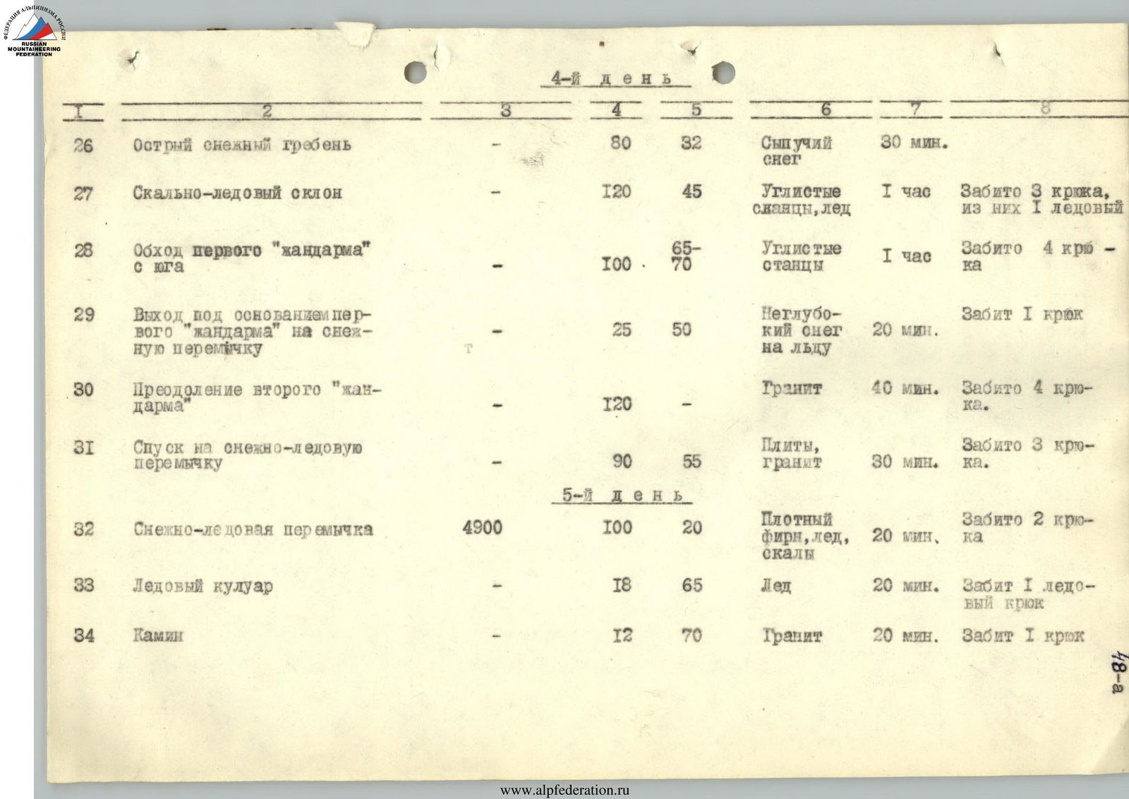
| Day 4 | |||||||
| 26 | Sharp snow ridge | — | 80 | 32 | Loose snow | 30 min | |
| 27 | Rock-ice slope | — | 120 | 45 | Carbonaceous schist, ice | 1 hour | 3 screws driven, 1 ice |
| 28 | Bypassing first "gendarme" from the south | — | 100 | 65–70 | Carbonaceous schist | 1 hour | 4 screws driven |
| 29 | Exit under the base of the first "gendarme" onto a snow saddle | — | 25 | 50 | Shallow snow on ice | 20 min | 1 screw driven |
| 30 | Overcoming the second "gendarme" | — | 120 | — | Granite | 40 min | 4 screws driven |
| 31 | Descent onto a snow-ice saddle | — | 90 | 55 | Slabs, granite | 30 min | 3 screws driven |
| Day 5 | |||||||
| 32 | Snow-ice saddle | 4900 | 100 | 20 | Compact firn, ice, rocks | 20 min | 2 screws driven |
| 33 | Ice couloir | — | 18 | 65 | Ice | 20 min | 1 ice screw driven |
| 34 | Chimney | — | 12 | 70 | Granite | 20 min | 1 screw driven |
| Section # | Sections | Altitude (m above sea level) x/ | Length of section (m) | Average steepness (°) xx/ | Terrain characteristics | Time taken to complete section | Notes |
|---|---|---|---|---|---|---|---|
| 35 | Traverse of the wall of the third "gendarme" from the south | — | 40 | 70 | Granite | 1 hour 10 min | 3 screws driven |
| 36 | Ascent to the summit of the third "gendarme" | — | 35 | 65 | Granite | 50 min | 2 screws driven |
| 37 | Rock ledge | — | 20 | — | Granite | 30 min | 1 screw driven |
| 38 | Descent to the fourth "gendarme" | — | 65 | 70–80 | Slabs | 1 hour 30 min | 4 screws driven |
| 39 | Overcoming the fourth "gendarme" | — | 160 | — | Snow, rocks | 1 hour 30 min | 2 screws driven |
| 40 | Descent to the south | — | 30 | 50 | Rocks, ice | 30 min | 2 screws driven |
| 41 | Traverse of the ice couloir | — | 10 | 60 | Ice | 30 min | 1 ice screw driven |
| 42 | Ledge on the southern wall of the fifth "gendarme" | — | 35 | — | Rocks, ice |