St. Petersburg Climbing Championship
2014
Description of the ascent to the summit of Kara-Kaya (3646 m) via the central buttress of the southwest wall, 6A category of difficulty (E. Poltavets, 2010)
ROUTE COMPLETED BY TEAM FASIL Team captain - Nikitin Andrey Borisovich
Ascent Passport
- Central Caucasus, Bezengi gorge, section No. 2.5 of the route classifier for mountain peaks, point 2.5.226
- Name of the summit: Kara-Kaya (3646 m), route name: via the central buttress of the southwest wall (E. Poltavets, 2010)
- Category of difficulty: 6A
- Route type: rock climbing
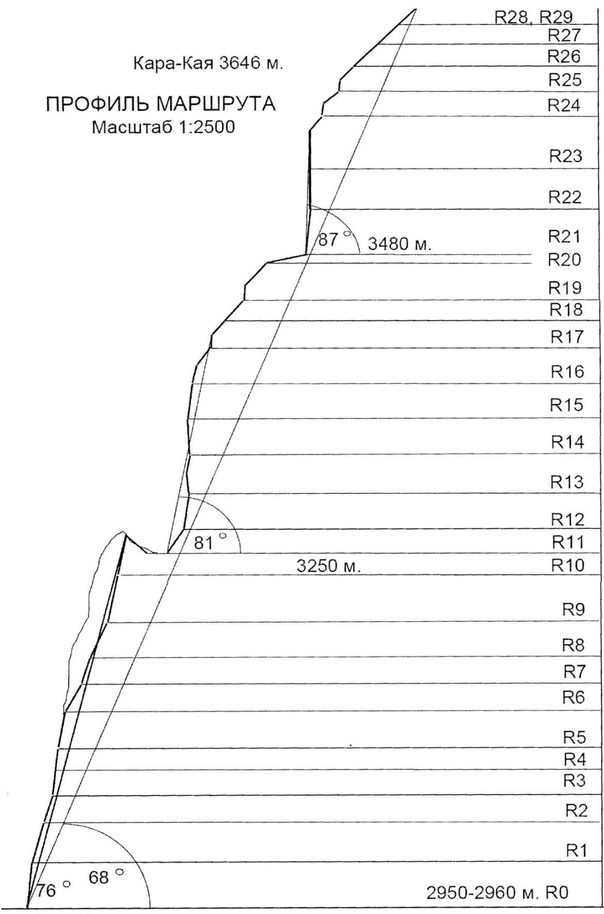
- Elevation gain: 700 m (by altimeter)
Route length: 1151 m. Section lengths:
- V category of difficulty – 245 m,
- VI category of difficulty – 491 m. Average steepness:
- first bastion: 76°,
- second bastion: 81°,
- third bastion: 87°,
- entire route: 68°.
- Number of pitons used ( denominator for artificial protection points):
rock pitons: 127/71, chocks: 144/57, stationary pitons: 8, including for artificial protection points – 0 (all left by the first ascenders). Total artificial protection points used – 128. Pitons left on the route: 1
- Team's total climbing hours: 55 hours, 6 days
- Leader: Nikitin Andrey Borisovich, Candidate Master of Sports.
Team members:
- Baranov Vladimir Yuryevich, Candidate Master of Sports
- Kurdyumov Oleg Anatolyevich, 1st sports category
- Coach: Nikitin Andrey Borisovich, Candidate Master of Sports, 3rd category instructor
- Departure to the route: 7:00 June 25, 2014
Reached the summit: 10:30 June 30, 2014. Returned to base camp: July 2, 2014
General photo of the summit

- route via the central buttress of the southwest wall, 6A (E. Poltavets, 2010), completed by the team.
- route via the center of the southwest bastion, 5B (E. Poltavets, 2009)
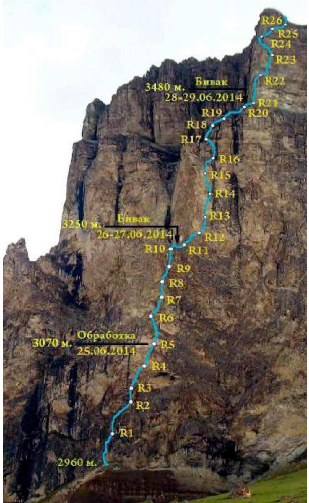
Drawn route profile
Photopanorama of the area
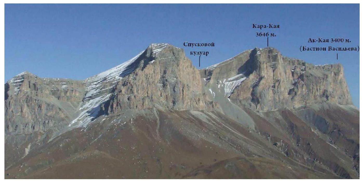
View from the Chegem gorge.
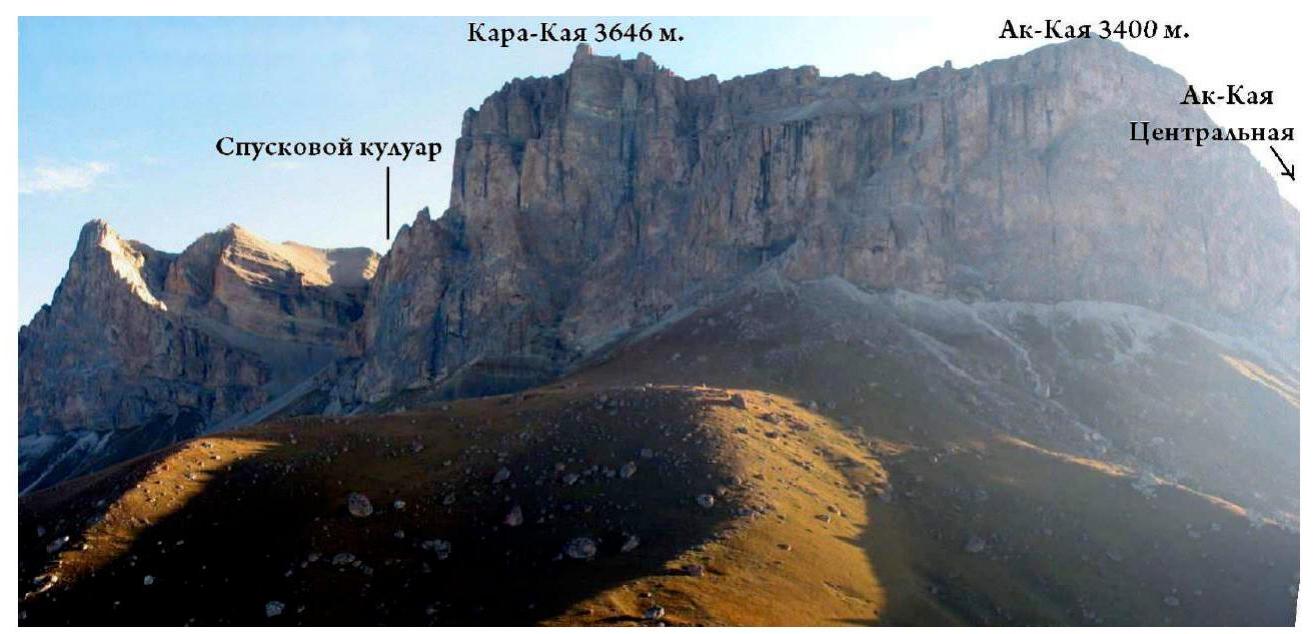
View from the Bezengi gorge.
Route diagram in UIAA symbols
| Section | Pitons | Chocks | Bolts for protection/artificial protection | Length (m) | Steepness (°) | Difficulty | |
|---|---|---|---|---|---|---|---|
| R28–R29 | 3 | 130 | 50 | 2 | |||
| R27–R28 | 1 | 6/2 | 8 15 20 | 90 50 50 | 6 2 3 | ||
| R26–R27 | 1/1 | 3/2 | 8 15 | 90 50 | 6 2 | ||
| R25–R26 | 7/6 | 12/10 | 40 10 | 90 45 | 6 2 | ||
| R24–R25 | 5/3 | 7/3 | 1/0 | 35 | 90 | 6 | |
| R23–R24 | 9/7 | 10/10 | 1/0 | 20 25 | 85 95 | 6 6 | |
| R22–R23 | 1 | 5 | 25 | 90 | 3 | ||
| R21–R22 | 3 | 30 | 50 | 1 | |||
| R20–R21 | 6/4 | 5/3 | - |  | 15 35 | 95 50 | 6 2 |
| R19–R20 | 4/2 | 5/2 | - |  | 10 10 | 90 60 | 6 3 |
| R18–R19 | 4/2 | 9/3 | - |  | 25 15 | 85 60 | 6 4 |
| R17–R18 | 4/3 | 8/6 | 1/0 |  | 20 10 | 90 80 | 6 5 |
| R16–R17 | 13/12 | 3/2 | 1/1 |  | 30 | 95 | 6 |
| R15–R16 | 10/10 | 6/5 | 1/1 |  | 15 15 | 100 80 | 6 6 |
| R14–R15 | 8/8 | 5/4 | 1/0 |  | 35 | 85 | 6 |
| R13–R14 | 7 | 5 | 1/0 |  | 25 20 | 90 60 | 6 5 |
| R12–R13 | 3 | 4 | - |  | 15 20 | 60 30 | 4 2 |
| R11–R12 | - | - | 1/0 |  | 35 | 60 | 3 |
| R10–R11"" | 4 | 4 | 1/0 |  | 35 | 80 | 5 |
| R9–R10 | 7/5 | 8/5 | - |  | 10 40 | 70 90 | 4 6 |
| R8–R9 | 6 | 5 | - |  | 40 | 75 | 5 |
| R7–R8 | 5 | 5 | 1/0 |  | 30 | 80 | 6 |
| R6–R7 | 4 | 6 | - |  | 25 15 | 75 65 | 5 3 |
| R5–R6 | 6/5 | 9/4 | - |  | 40 10 | 90 80 | 6 5 |
| R4–R5 | 4/3 | 6/1 | 1/0 |  | 30 | 85 | 6 |
| R3–R4 | 4/2 | 5/1 | - |  | 25 | 85 | 6 |
| R2–R3 | 3 | 4 | 1/0 |  | 30 | 75 | 5 |
| R1–R2 | 3 | 6 | - |  | 15 15 15 | 80 60 90 | 5 3 5 |
| R0–R1 | 4/3 | 9 | - | 45 | 80 | 5 |
Route description by sections
R0–R1. Move up the internal corner, initially on artificial protection points, then climbing. 45 m 5. R1–R2. Move up the crack to the right 10 m, then 15 m across simple rocks to a vertical wall. Climb the wall to a ledge under the cornice. 15 m 4; 15 m 3; 15 m 5. R2–R3. From the belay station, traverse 5 m left and then up the corner to a large ledge. Bolt. 30 m 4. R3–R4. Move up the destroyed, partially overhanging crack to the right. 25 m 6. R4–R5. Continue up the destroyed, partially overhanging crack to the right. Enter the chimney. There is a bolt. 30 m 6. R5–R6. Bypass the plug. Exit the chimney. Move left and up to a ledge. 10 m 3; 30 m 5. R6–R7. Along the ledge, approach the "Finger" outcrop. Climb it 25 m. 10 m 1; 25 m 4. R7–R8. Climb the wall 30 m. Belay station on a sloping ledge with a bolt. 30 m 5. R8–R9. Climb to a comfortable ledge. 40 m 4. R9–R10. Move right to a bolt, then climb a steep, destroyed wall to the right and up to an internal corner. Climb the corner to a ledge. 20 m 6; 30 m 5. R10–R11. Exit to the ridge. There is a bolt (comfortable bivouac). Along the ridge, approach the "Iron" 20 m 3; 15 m 1. R11–R12. Climb the slabs to under the overhanging wall, then difficult traverse along the ledge to the right to a bolt. 20 m 3; 25 m 5. R12–R13. Climb right to a crack on artificial protection points, then complex climbing 10 m. Then climb the wall to the right to a bolt. 30 m 6. R13–R14. Traverse to an overhanging internal corner. Climb the corner (there is a bolt), overcome the cornice, and continue climbing to a ledge with a bolt. 15 m 6; 15 m 5. R14–R15. Climb the corner 10 m, then the slab to an overhanging corner (there is a bolt). Climb the corner 15 m. Uncomfortable belay station. 30 m 6. R15–R16. Climb, under the cornice. Overcome the cornice and exit to a ledge. 15 m 5; 5 m 6; 10 m 4. R16–R17. Move right to an internal corner, climb the corner to a ledge. Traverse the ledge left to the buttress. 20 m 5; 15 m 3. R17–R18. Overcome the wall and move left across easy rocks to a ledge. 10 m 5; 10 m 3. R18–R19. Traverse the ledge left. 20 m 2. R19–R20. Climb the wall, exit to easy, destroyed rocks. Climb, approaching a bolt in a monolith. 10 m 5; 40 m 2. R20–R21. Traverse the scree right to the third bastion. 30 m 1. R21–R22. Start the climb left of the buttress. Move right and up through an internal corner with a cornice and then to a ledge with a bolt (right of the buttress). 20 m 5; 25 m 6. R22–R23. Climb the wall to an outcrop. Belay station right, at its base. Bolt. 30 m 6. R23–R24. Move 5 m right to a corner. Climb the corner under the cornice. Overcome the cornice (artificial protection points) and climb, moving left. The last cornice is passed in the left part. Then climb 8 m through a vertical wall to a scree ledge. 40 m 6; 10 m 1. R24–R25. Overcome a short, difficult wall and climb the scree to under the next rise of the buttress. 8 m 5; 15 m 2. R25–R26. Move right around the corner. Approach an internal corner. Climb the corner, then across strongly destroyed rocks to a monolithic wall. 10 m 5; 15 m 2. R26–R29. Climb easy, strongly destroyed rocks. Sometimes there are short, steep walls. Exit to the summit ridge. 130 m 2. Climb the ridge to the summit of Kara-Kaya 3646 m. 30 m.
Movement schedule
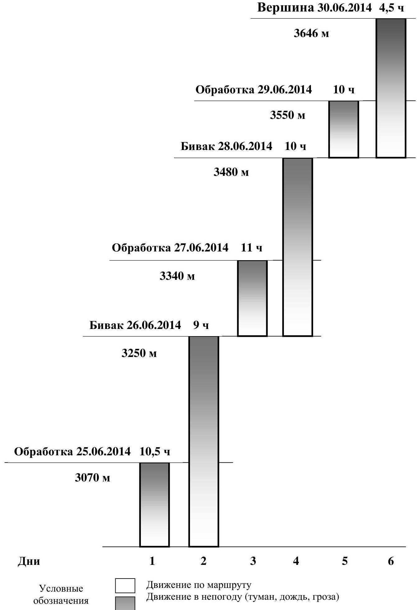
Summit June 30, 2014 4.5 hours 3646 m Processing June 29, 2014 10 hours 3550 m Bivouac June 28, 2014 10 hours 3480 m Processing June 27, 2014 11 hours 3340 m Bivouac June 26, 2014 9 hours 3250 m Processing June 25, 2014 10.5 hours 3070 m
Days 1 2 3 4 5 6
Conventions
Movement on the route Movement in bad weather (fog, rain, thunderstorm)
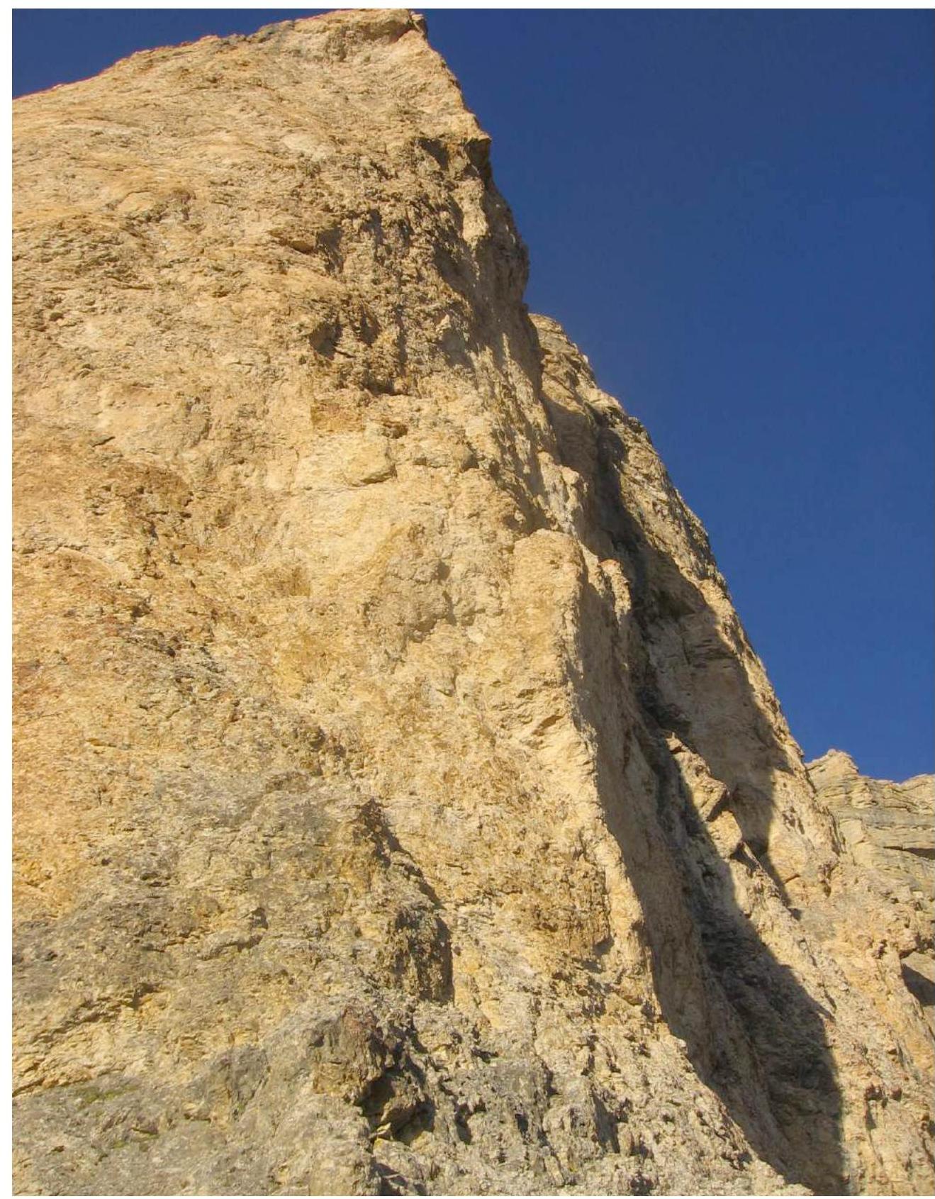
Technical photo of the route
Note from the summit
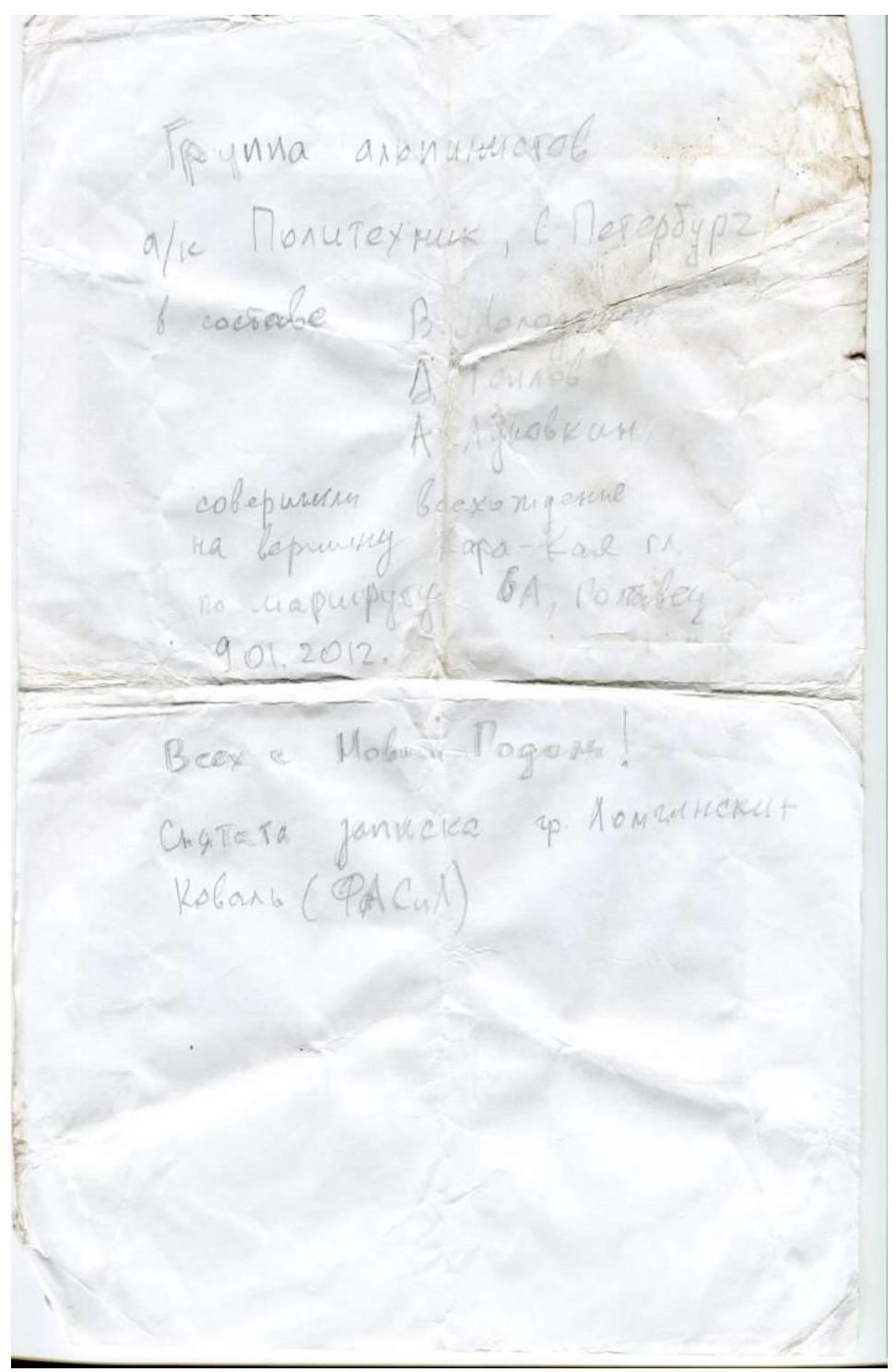
Group of climbers from Polytechnic Sports Club, St. Petersburg including Atoilov Aslunovkin completed an ascent to the summit of Kara-Kaya via the 6A route, Poltavets January 9, 2012 "Happy New Year!" Note taken by group Lomenensky Koval (Fasil) Note taken from group of Polytechnic Sports Club St. Petersburg, led by V. Molodozhen on January 9, 2012
Report photo illustration

Section R3–R4
Lower part of the second bastion. R12–R15
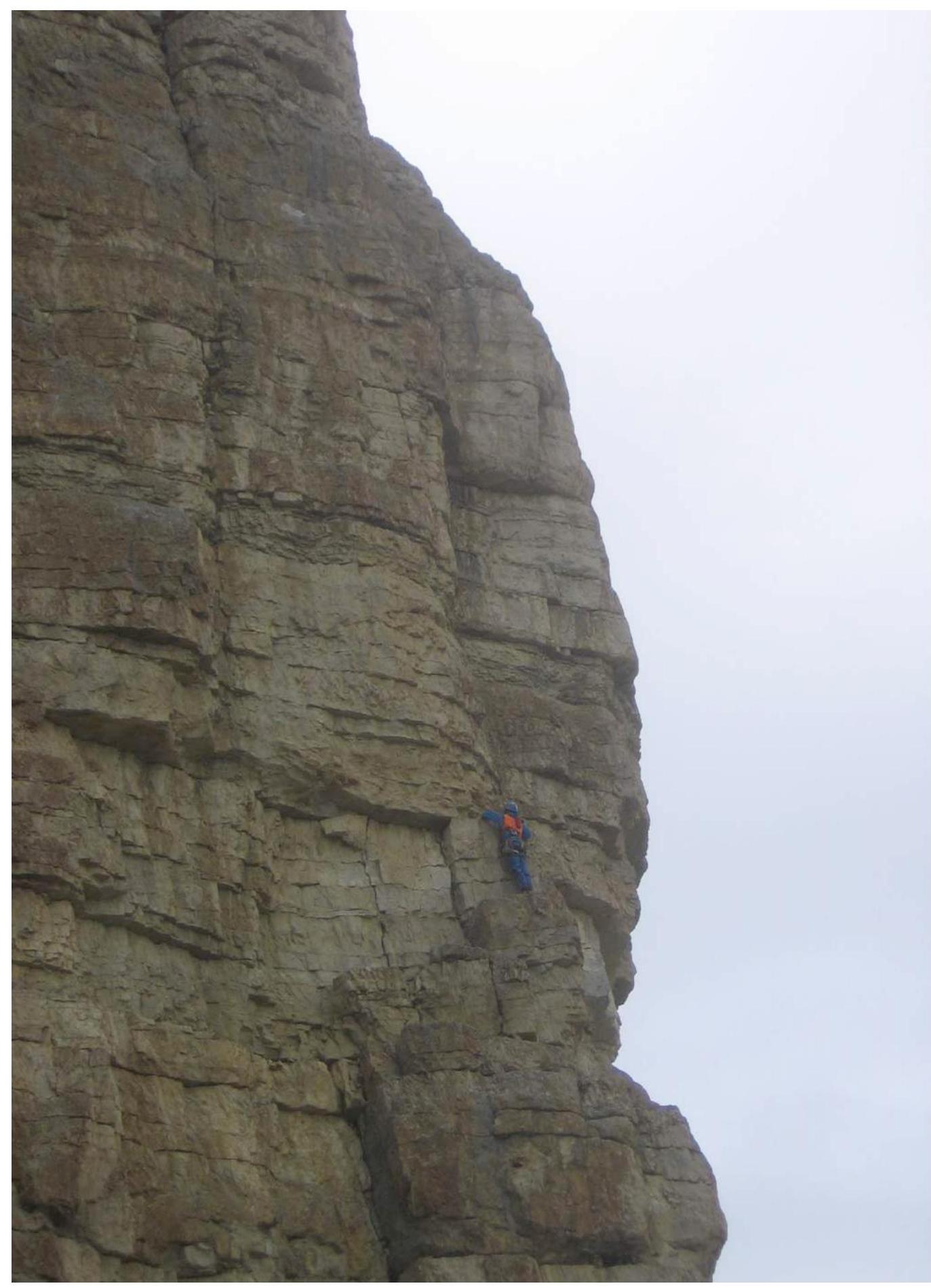
Section R21–R22

Section R22–R23
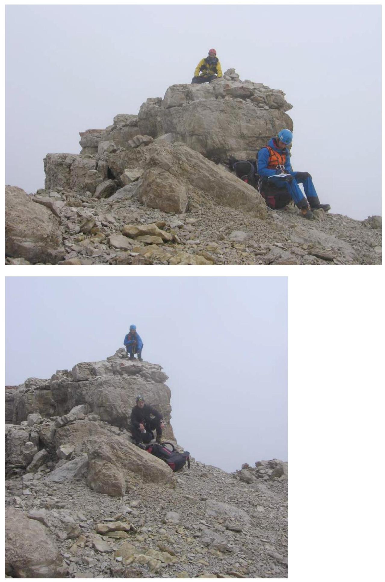
Group on the summit
Participants' email addresses
Nikitin Andrey ab_vet@mail.ru