REPORT
on the Dykhtau – Koshtan traverse of 6A category of complexity by the team from St. Petersburg from 30.08.2020 to 5.09.2020 2020
I. Climbing Report
| 1. General Information | ||
|---|---|---|
| 1.1 | Full Name, Sports Rank of the Leader | Kashevnick Anton Alexandrovich, CMS |
| 1.2 | Full Name, Sports Rank of the Participants | Panov Andrey Olegovich, 1st sports rank, Seryanov Sergey Alexandrovich, 1st sports rank |
| 1.3 | Full Name of the Coach | Kashevnick Anton Alexandrovich |
| 2. Characteristics of the Climbing Object | ||
| 2.1 | Region | Central Caucasus |
| 2.2 | Valley | Bezengi |
| 2.3 | Section Number according to the 2013 Classification Table | 2.5.60 |
| 2.4 | Name and Height of the Peak | Dykhtau Main (5204) – Koshtan (5151) |
| 3. Characteristics of the Route | ||
| 3.1 | Route Name | Traverse, ascent via the South Main Couloir (5A) |
| 3.2 | Category of Complexity | 6A |
| 3.3 | First Ascent of the Route | E. Abalakov – V. Miklashevsky, 1938 |
| 3.4 | Terrain Characteristics of the Route | Combined |
| 3.5 | Height Difference of the Route | 1200 m |
| 3.6 | Length of the Route | About 12 km |
| 3.7 | Technical Elements of the Route | Ice 50° – 1000 m. Ice 65° – 70 m. Rocks IV – 620 m. Rocks V – 100 m. |
| 3.8 | Average Steepness of the Route | - |
| 3.9 | Average Steepness of the Main Part | - |
| 3.10 | Descent from the Summit | Along the northern ridge of Koshtan |
| 4. Characteristics of the Team's Actions | ||
| 4.1 | Time of Movement (team's walking hours, indicated in hours and days) | 82 h, 7 days (+7 h for descent) |
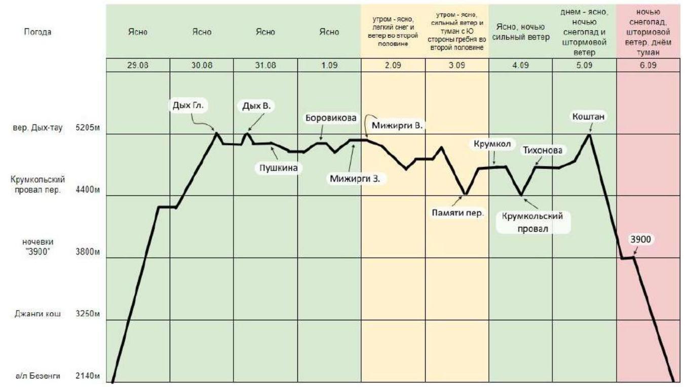
| 4.2 | Overnights | 1st – saddle between Dykhtau peaks, 2nd – on the ridge between Pushkin Peak and Borovikov Peak, 3rd – before Mizhyrgi W., 4th – on descent from the Mizhyrgi massif, 5th – on Krumkol Peak, 6th – on Tikhonov Peak. |
| 4.3 | Time Spent on Route Preparation | Absent |
| 4.4 | Start of the Route | 6:00, 30.08.2020 |
| 4.5 | Summit Ascent | Dykhtau Main (5204 m) – 17:00, August 30, 2020. Dykhtau E. (5150 m) – 10:30, August 31, 2020. Pushkin Peak (5100 m) – 16:30, August 31, 2020. Borovikov Peak (4888 m) – 12:00, September 1, 2020. Mizhyrgi W. (5025 m) – 16:15, September 1, 2020. Mizhyrgi E. (4927 m) – 10:30, September 2, 2020. Krumkol (4676 m) – 18:30, September 3, 2020. Tikhonov Peak (4670 m) – 18:30, September 4, 2020. Koshtan (5151 m) – 16:30, September 5, 2020. |
| 4.6 | Return to the "Bezengi" Alpine Camp | 19:00, September 6, 2020 |
| 5. Person Responsible for the Report | ||
| 5.1 | Full Name, e-mail | Kashevnick Anton Alexandrovich, atonik@bk.ru |
II. Climbing Description
1. Characteristics of the Climbing Object
1.1. Overview of the Region
Bezengi is a mountain region in Kabardino-Balkaria, the central, highest part of the Caucasus Mountains. It is one of the most popular mountaineering regions in the Caucasus. The mountain massifs are home to six "five-thousanders". Bezengi is the most severe climbing region in the Caucasus, with the most powerful glaciation. Most routes are of a combined nature. Routes of categories from 1B to 6B are laid out in this region. The most famous massifs in the region are the Bezengi Wall and the Northern Massif.
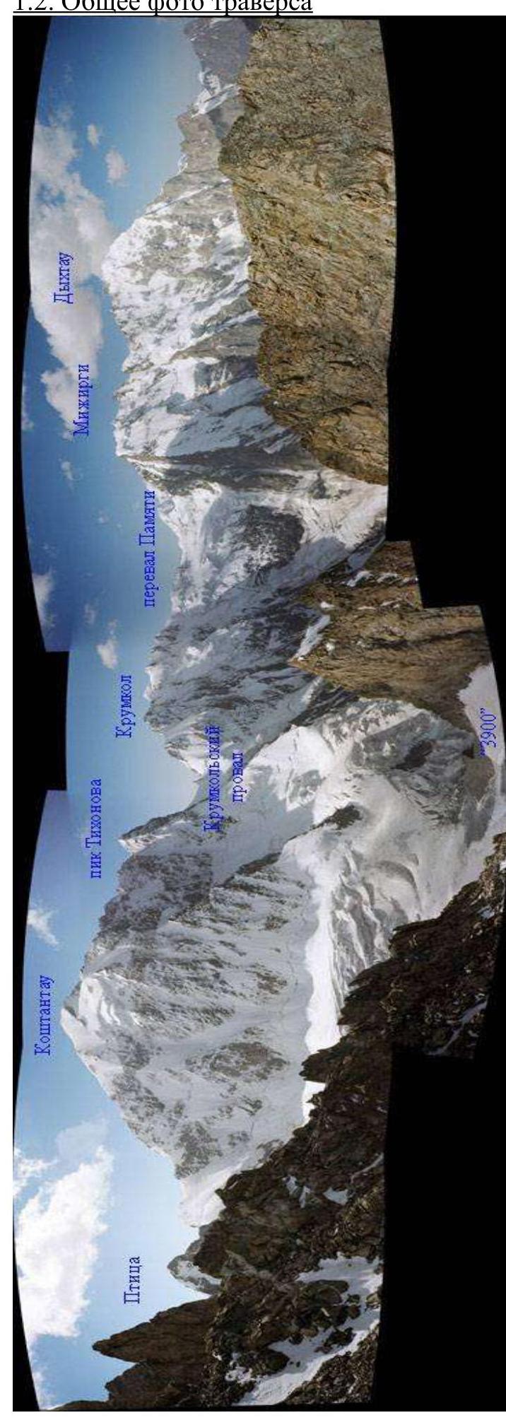
The Northern Massif is a gigantic 15-kilometer horseshoe of nine main peaks, located from east to west:
- Koshtantau, 5151 m
- Tikhonov Peak, 4670 m
- Krumkol, 4676 m
- East Mizhyrgi, 4927 m
- West Mizhyrgi, 5025 m
- Borovikov Peak, 4888 m
- Pushkin Peak, 5100 m
- East Dykhtau, 5180 m
- Main Dykhtau, 5204 m
To the south, the Northern Massif drops with rock walls, buttresses, and ridges. From the north, it is girded by several tiers of hanging giant ice drops. The ridge of the massif is snowy-icy, with sharp rocky jumbles, steep ice climbs, and snowy cornices. The northern slope of the massif receives a lot of precipitation, contributing to significant glaciation of the ridge from the north. From the north, most routes are classified as 5A–5B category of complexity. There are five routes of 6A category of complexity. Currently, many routes from the north are objectively hazardous due to abundant ice melting. Routes from the south are simpler (4–5 category of complexity), as the slopes have less snow cover, glaciation, and steepness.
In general, the routes of the Northern Massif are characterized by long distances, a large height difference of up to 2000 m, and an abundance of technically complex, combined ice-snow and rock sections. The Dykhtau peak (5204 m) – the second highest peak in the Caucasus and Russia after Elbrus – closes the Northern Massif from the west. More than 10 mountaineering routes are laid out on Dykhtau. The first ascent to the peak was made in 1888 by Albert Mummery and Zarflu via the southwest ridge (4B). The traverse of the entire Northern Massif was first traversed in 1938 by E. Abalakov and V. Miklashevsky.
The popularity of traverses has dropped significantly in recent years: the previous passage of the Northern Massif from Koshtan to Dykhtau was in 2010. Due to the epidemiological situation in 2020 and the impossibility of traveling outside Russia, our team decided to go to the "Bezengi" region to complete the Traverse from Dykhtau to Koshtan.
Food caches were not made; the route was climbed by climbing, without using fixed ropes. Each participant had two ice tools, allowing the entire team to climb, especially useful on snowy-icy traverses, which are abundant on the route.
1.2. General Photo of the Traverse
1.3. Photo of the Route Profile
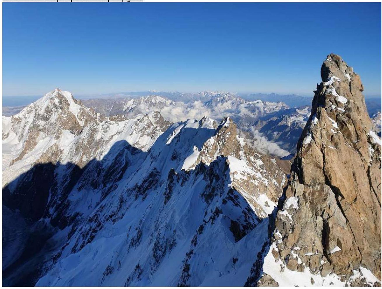
View from the saddle between Dykhtau peaks.
1.4. Height Graph
1.5. Panoramic Photos of the Region
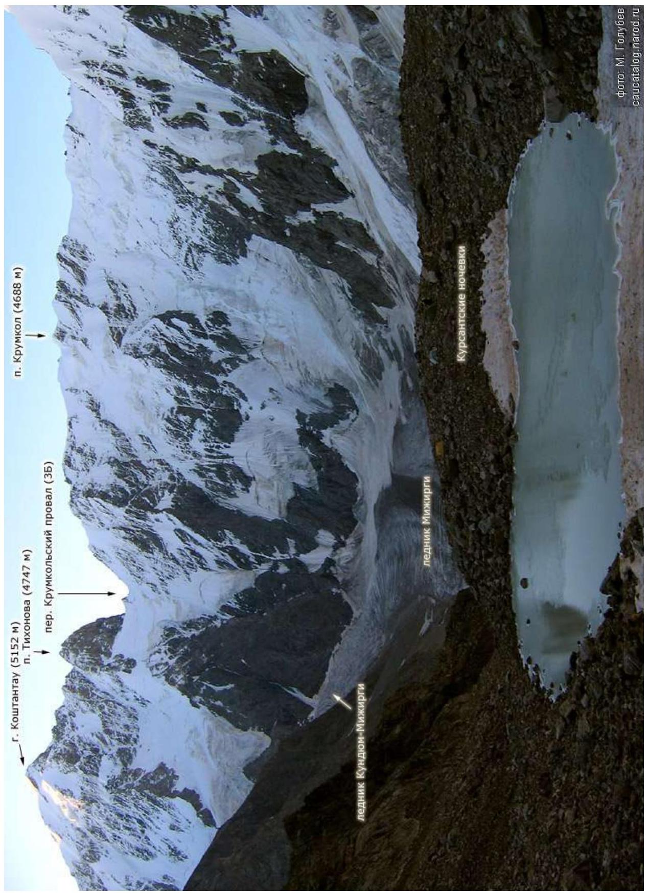
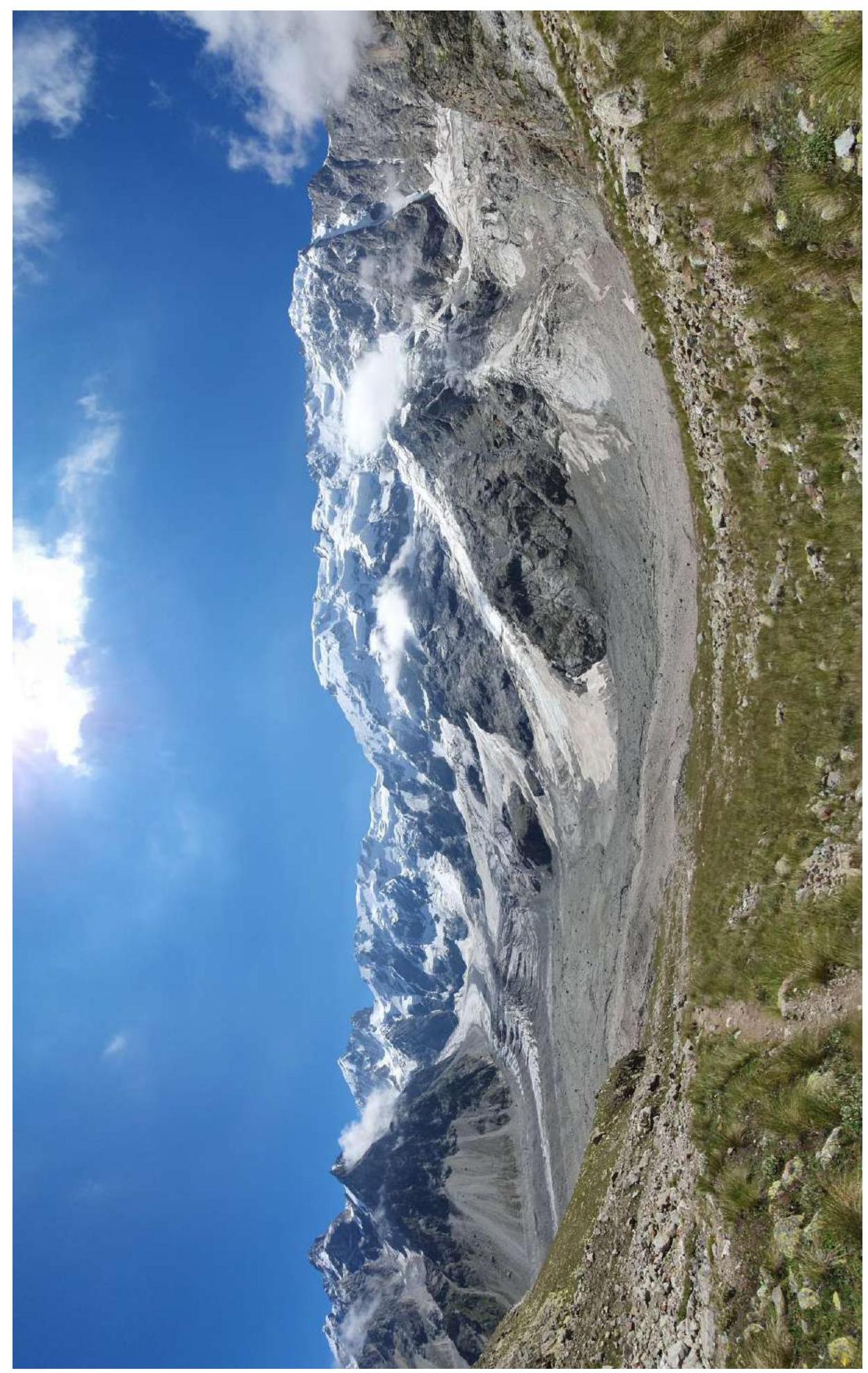
View from the Mizhyrgi Glacier.
View from the "Cadet" overnight camps.
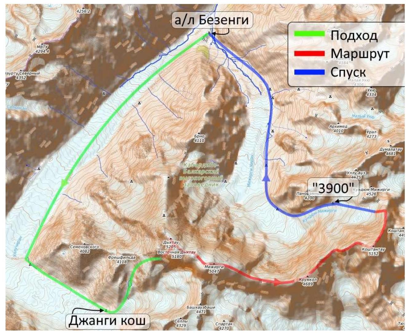
1.6. Map of the Region
2. Characteristics of the Route
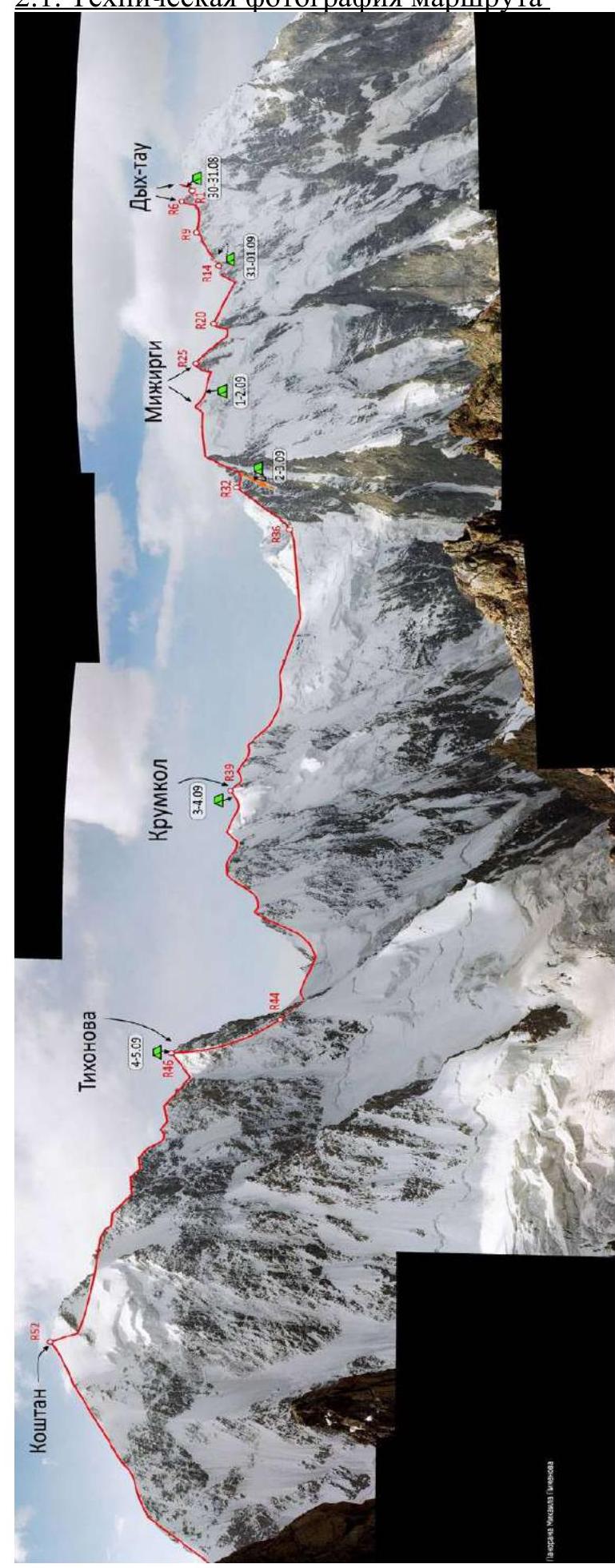
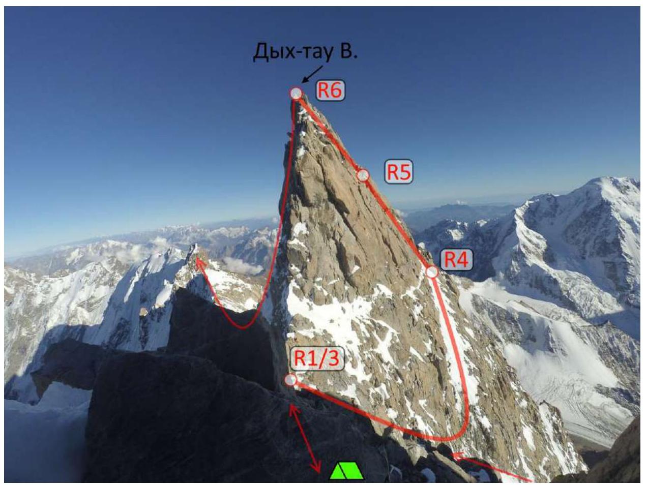
2.1. Technical Photograph of the Route
2.2. Route Description by Sections
30.08: R0–R1 – ice, 50°, 600 m R1–R2 – rocks, IV, 150 m R2–R3 – 3 rappels of 50 m each Dykhtau Main
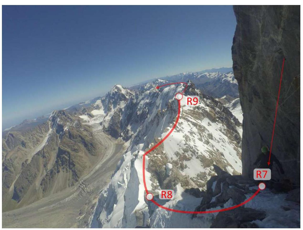
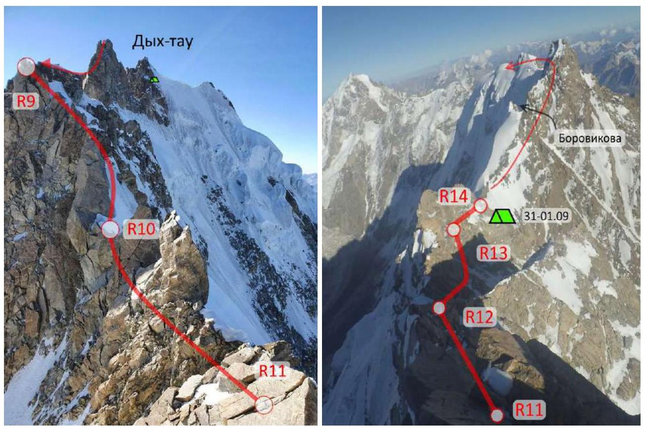
31.08: R3–R4 – ice, 50°, 150 m R4–R5 – rocks, V, 30 m, II, 20 m R5–R6 – rocks, IV, 50 m Dykhtau E. R6–R7 – rappel 50 m R7–R8 – rappel 50 m R8–R9 – rocks, snow, II, 200 m Pushkin Peak R9–R10 – rocks, ice, IV, 50 m R10–R11 – rocks, IV, 70 m R11–R12 – rocks, IV, 100 m R12–R13 – rocks, III, 100 m R13–R14 – rocks, ice, IV, 100 m
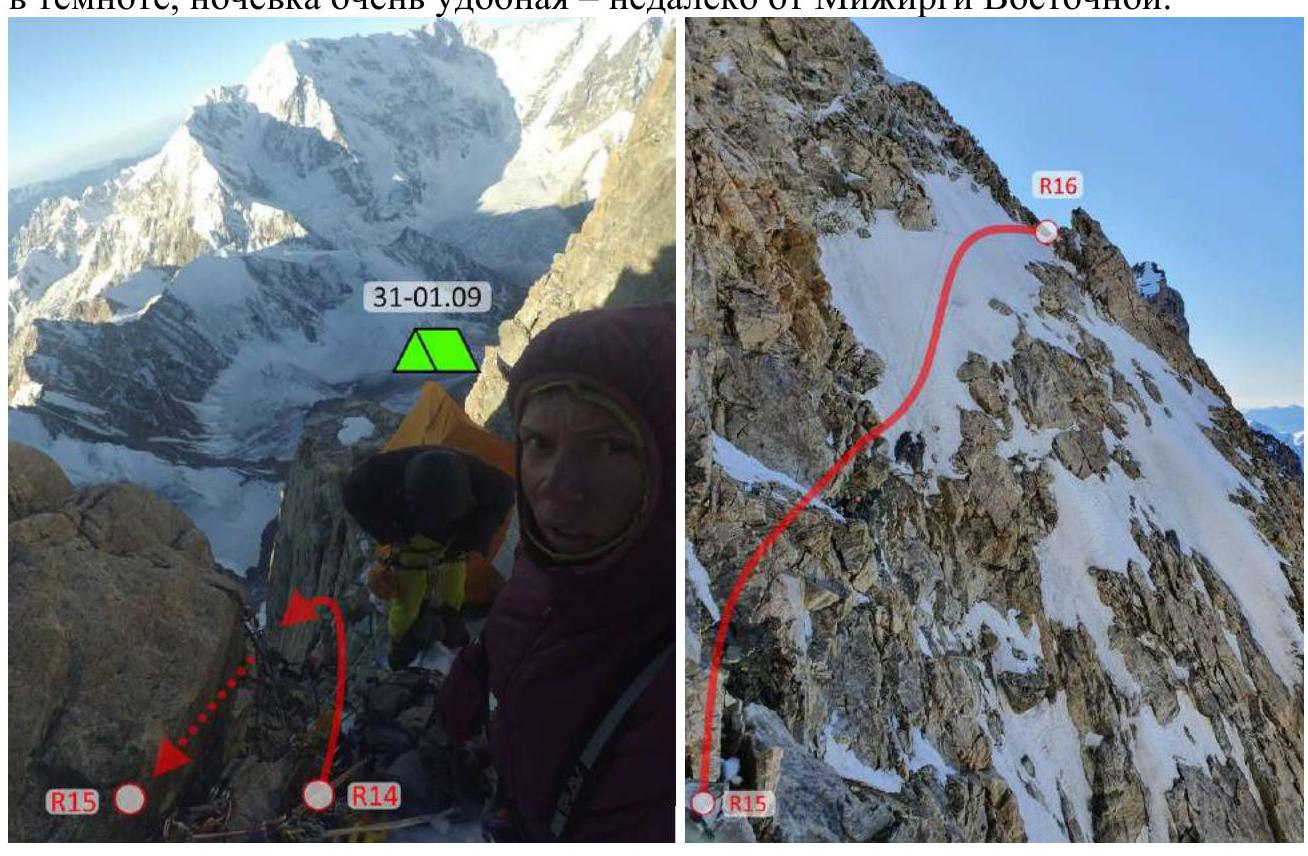
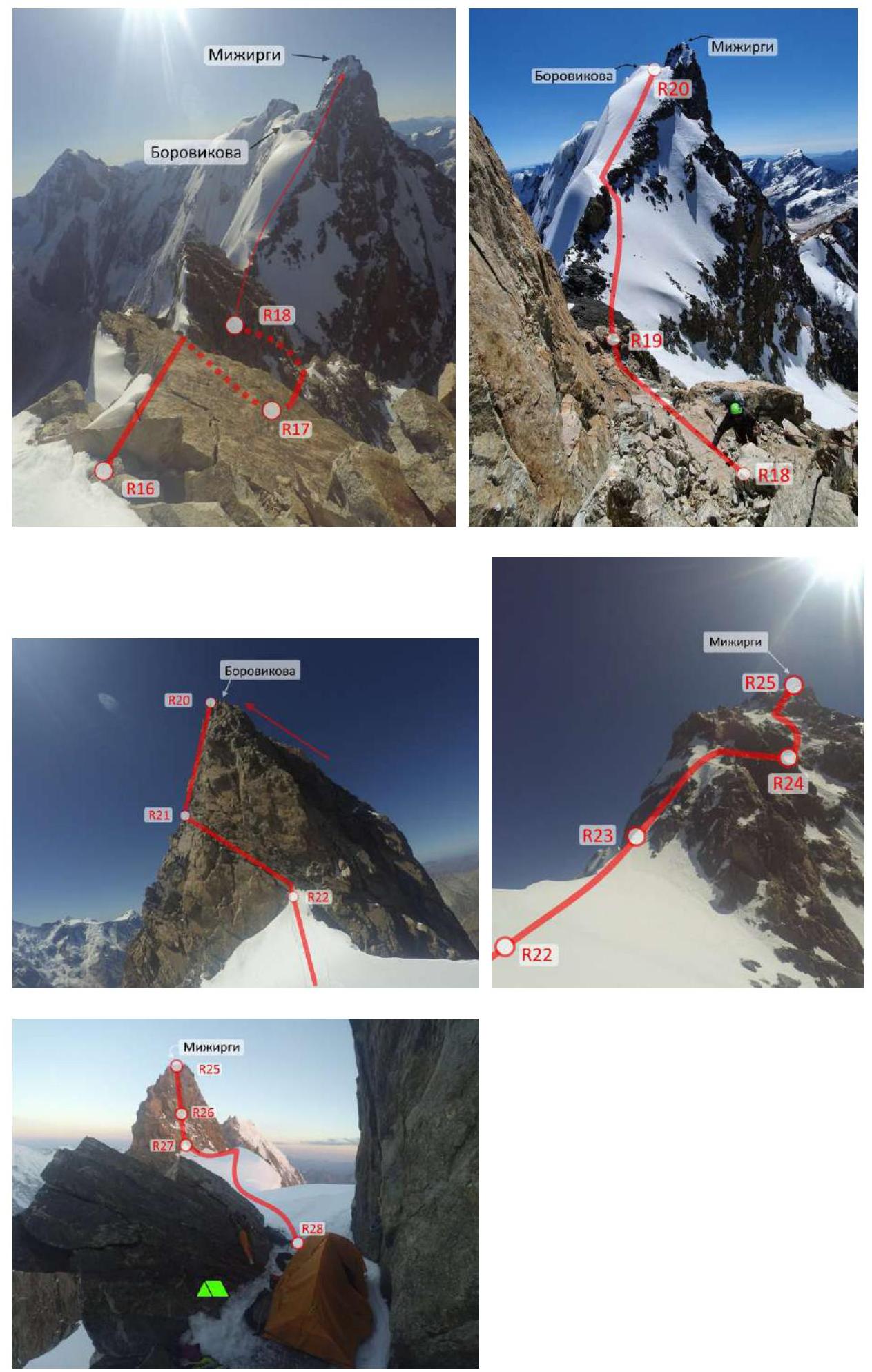
01.09: R14–R15 – rappel 50 m R15–R16 – ice, rocks, IV, 150 m R16–R17 – rappel 50 m R17–R18 – rocks, III, 100 m R18–R19 – rappel 50 m R19–R20 – snow, 30° Borovikov Peak R20–R21 – rappel 50 m R21–R22 – rocks, III, 150 m R22–R23 – snow, 20° R23–R24 – rocks, IV–V, 150 m R24–R25 – ice, rocks, IV, 200 m Mizhyrgi W. R25–R26 – rappel 50 m R26–R27 – rappel 50 m R27–R28 – ice, snow, 20°
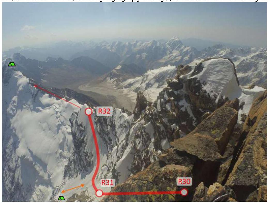
02.09: R28–R29 – ice, snow, 20° Mizhyrgi E. R29–R30 – ice, snow, 20° R30–R31 – rappel 50 m
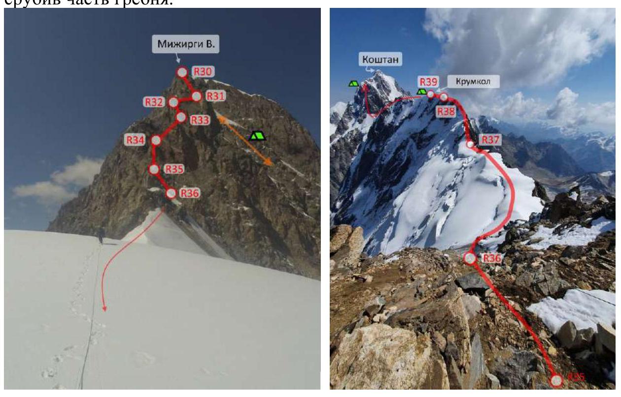
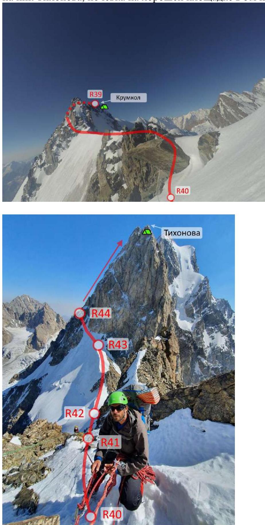
03.09: R31–R32 – ice, 50°, 100 m R32–R33 – rappel 50 m R33–R34 – rappel 50 m R34–R35 – rappel 50 m R35–R36 – rocks, snow, II, 100 m R36–R37 – rocks, snow, III, 300 m R37–R38 – rocks, snow, IV, 150 m R38–R39 – rocks, snow, III, 150 m Krumkol
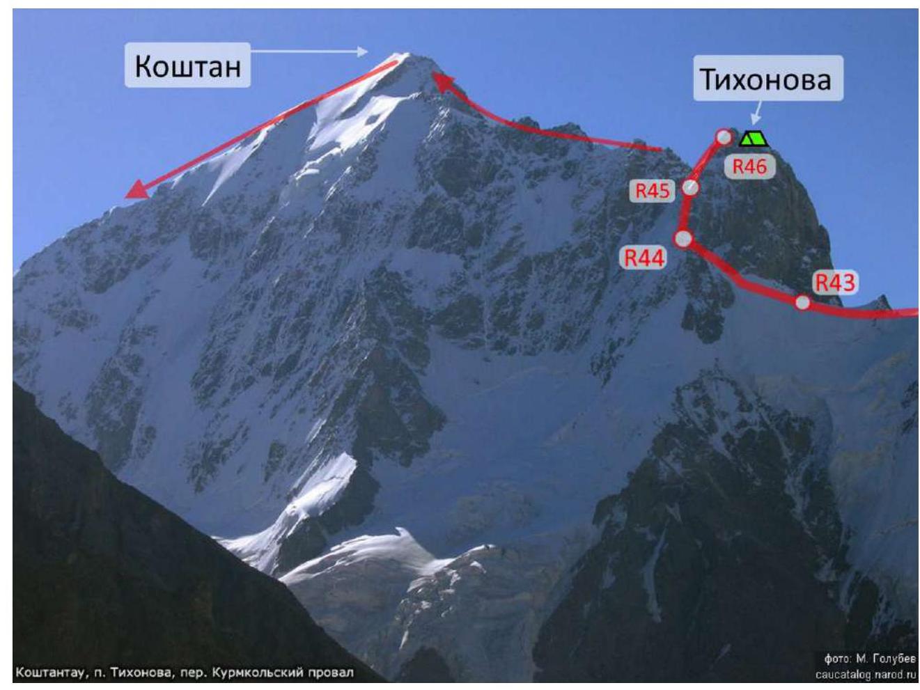
04.09: R39–R40 – snow, 20°, 200 m R40–R41 – rocks, snow, IV, 50 m R41–R42 – rappel 50 m R42–R43 – rocks, snow, III, 150 m R43–R44 – ice, 50°, 100 m R44–R45 – rocks, snow, IV, 150 m R45–R46 – rocks, snow, III, 150 m Tikhonov Peak
05.09: R46–R47 – rocks, snow, III, 100 m R47–R48 – rocks, snow, IV, 70 m, V, 20 m R48–R49 – rocks, snow, III, 150 m R49–R50 – rocks, snow, IV, 150 m R50–R51 – rocks, snow, III, 100 m R51–R52 – snow, 30°, 200 m Koshtan-Tau R52–R53 – snow, 20°, 300 m R53–R54 – rappel 50 m R54–R55 – snow, 20°, 300 m R55–R56 – 10 rappels, 500 m
3. Tactical Actions of the Team
Acclimatization
Aug 10 – the team arrived at the "Bezengi" alpine camp. Aug 12–13 – walked to the Austrian overnight camps (Djangi-Kosh). Aug 14 – moved to the Cadet overnight camps. Aug 15–16 – ascent to Misses-Tau 4B with overnight stay on the "shoulder". Aug 17–18 – rock training and bad weather. Aug 19 – moved under Ulluauz. Aug 20–21 – Ulluauz 5A with a planned overnight stay on the summit (4650 m) and descent via the "3900" overnight camps (to cache food – a stimulus to finish the Traverse). Aug 22–24 – rest, bad weather, waiting for a permit to cross the Main Caucasian Ridge. Aug 25–26 – not getting the desired permit, went to acclimatize on Elbrus. Aug 27 – rest. Aug 28 – first attempt to approach: at the checkpoint near the camp, they were allowed to pass, but at the checkpoint at the turn of the glacier, they were sent back home, citing an incorrectly filled-out permit; in the evening, they were back at the camp.
Ascent
August 29
Left the "Bezengi" alpine camp, passed the Djangi-Kosh hut, and approached Dykhtau from the south. Set up a comfortable overnight stay.
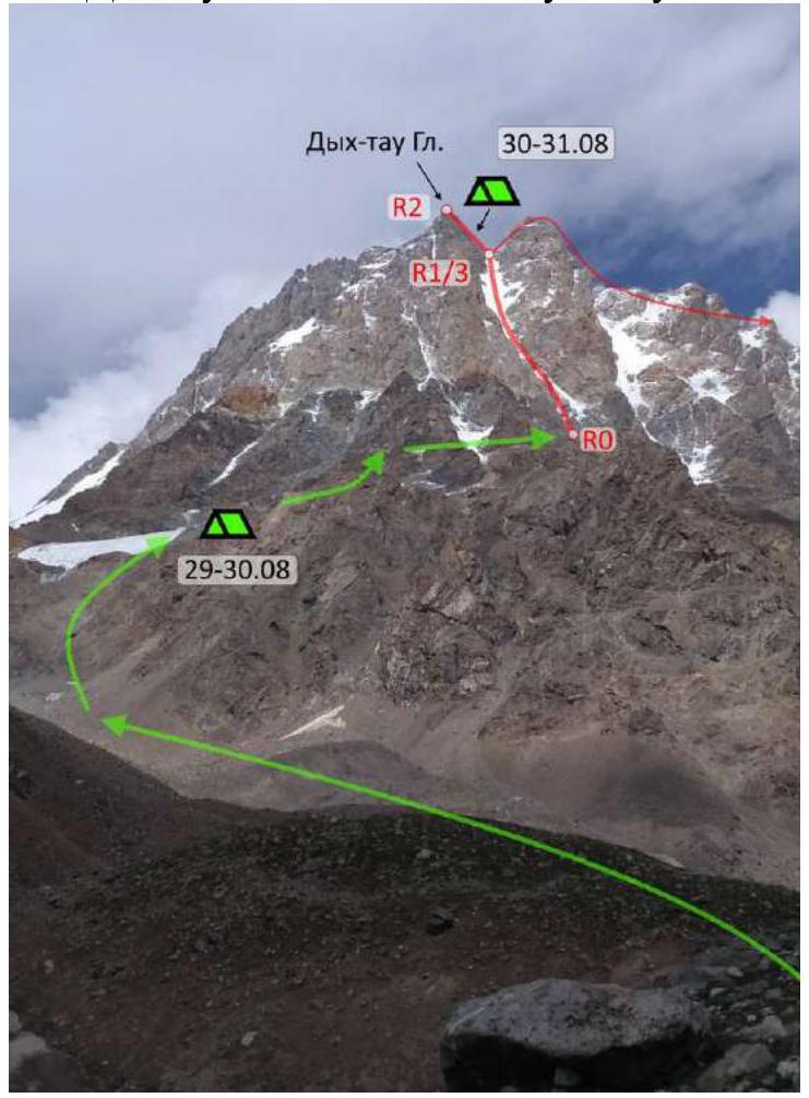
August 30, 1st day of ascent
Climbed, with minor back-and-forth, along a large horizontal ledge from left to right to the ice couloir separating the Main and East peaks of Dykhtau.
Climbed on ice simultaneously:
- The leader pulled two ropes at once
- 2nd and 3rd climbed at a short distance from each other
By evening, reached the saddle between the Main and East peaks of Dykhtau. Found two good overnight spots on the saddle. After leaving their gear, climbed to the Main Dykhtau peak: about 3 rock ropes, managed to find 5 m of complex climbing.
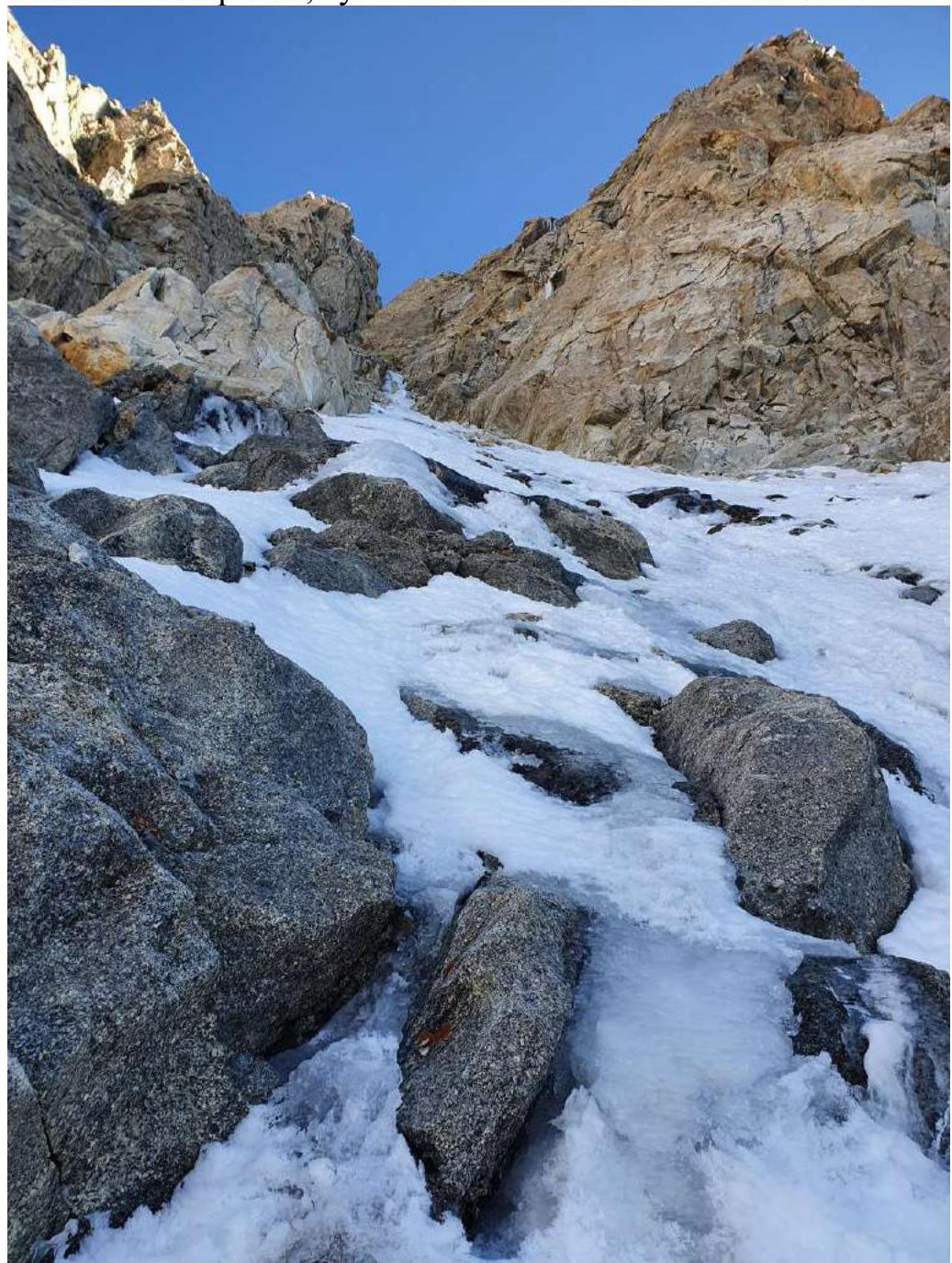
Route 5A via the South Main Couloir.
August 31, 2nd day of ascent
Crossed the ice to under Dykhtau East. Then:
- 2 rock ropes to the summit,
- 20 meters of snow between them.
From the summit:
- 3 rappels to the ridge,
- further along the ridge on foot to Pushkin Peak.
Immediately after the summit, the ridge becomes more complex.
View from the overnight stay.
From under Dykhtau E. summit.
September 1, 3rd day of ascent
A lot of snow, snowy-icy ridge, and rocky walls. Set up an overnight stay in the dark; the overnight spot is very convenient – near East Mizhyrgi.
September 2, 4th day of ascent
Moved along the ridge, bypassing gendarmes, rappelled in poor visibility down an icy couloir in the wrong direction. Set up an overnight stay at 15:00.
September 3, 5th day of ascent
Climbed up the previous day's couloir for 3 ropes. At the very top, there was bad ice. Then found the correct path along the ridge towards Krumkol.
Overnight stay on Krumkol peak:
- Leveled a small area in the snow,
- By chopping part of the ridge.
September 4, 6th day of ascent
Descended into the Krumkol gap, traversed the icy slope, then followed snowy-ice with small rocky sections. As the sun set, climbed to Tikhonov Peak, overnight stay on a good spot 5 m below the summit.
September 5, 7th day of ascent
The ridge from Tikhonov to Koshtan has many rocky walls; at the end, climbed to the summit for a long time on snow. Reached the Koshtan-Tau summit at 15:00. Then moved along the ridge towards the Ptytsa gendarme. The forecast was bad, so rappelled in the dark from the Ice Dome. Reached the "3900" overnight camps around 4:00 AM.
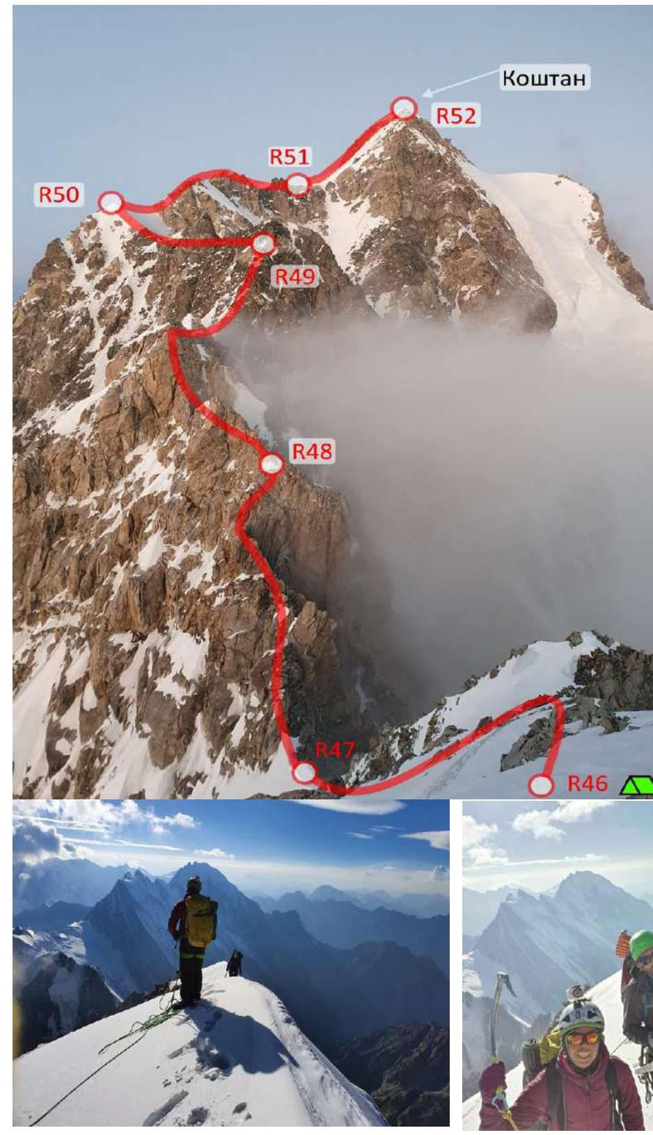
Moment of reaching the Koshtan-Tau summit.
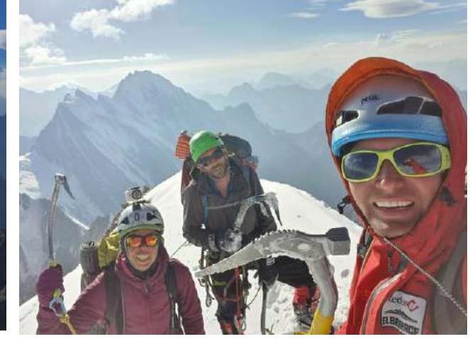
Team on the summit.
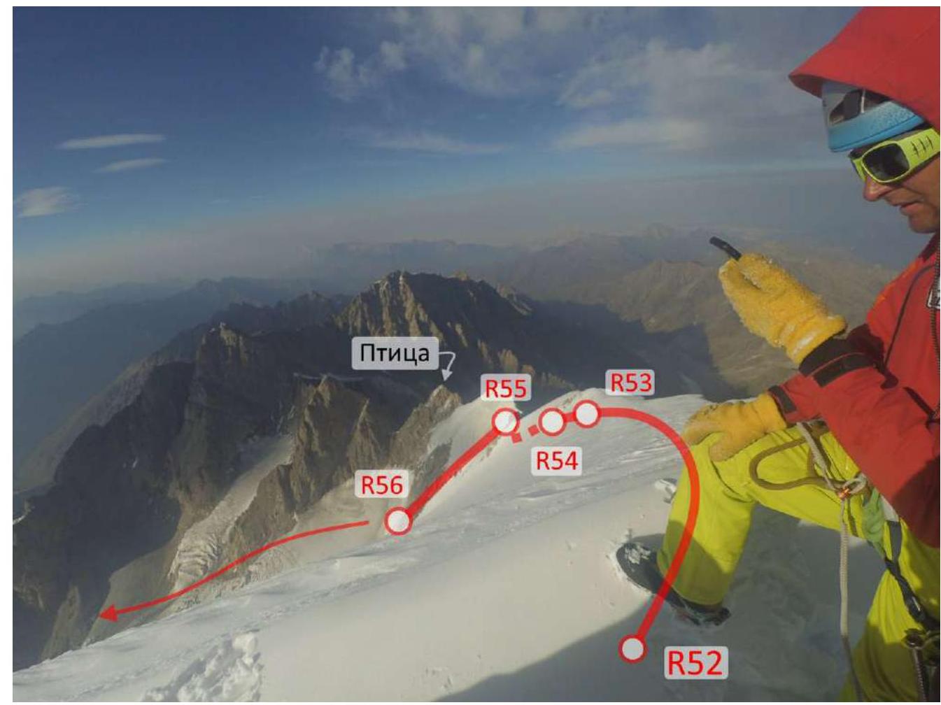
View from the Koshtan-Tau summit on the descent route.
September 6
Returned from the "3900" overnight camps to the "Bezengi" alpine camp. The cache made after descending from Ulluauz was very useful.
3.2. Notes from the Route

The note from West Mizhyrgi was lost along with the capsule; the rest are with us.
3.3. Safety Assessment of the Route
The traverse of the Northern Massif in either direction is a relatively safe route, as it goes along ridges; the possibility of descent in case of an emergency is not always available (we recommend carrying a guidebook with route descriptions, as it's impossible to remember them all).
Communication on the route: almost the entire route had a direct line of sight to the camp; relaying was necessary only on the first day – during the ascent to Dykhtau.
Recommendations for future climbers: the "Bezengi" alpine camp library has detailed reports from climbers from the mid-20th century – they are worth studying; a modern guidebook on the route would also be useful; since there are many icy traverses, we recommend:
- Carrying two ice tools per climber
- Climbing with belays
- Moving simultaneously whenever possible