Passport
- Ice and snow ascent class.
- Central Caucasus, Southern lateral spur of the Main Caucasian Range.
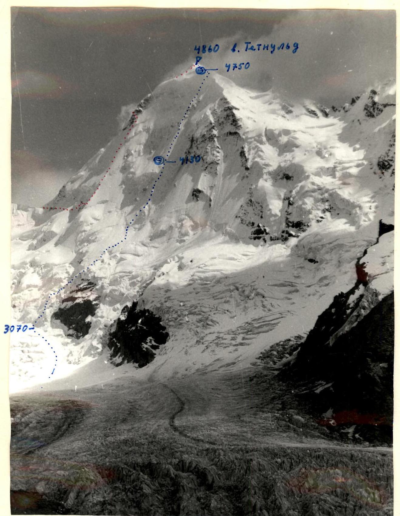
- Peak Tetnuld, center of the North face.
- Proposed - 5B category of difficulty, first ascent.
- Elevation gain 1780 m, length 2190 m.
Length of sections with 5–6 category of difficulty is 1768 m. Average steepness of main sections is 55° (R1–R2, R4–R14), including 6 category of difficulty 85–110° for 130 m (R12–R14).
- Pitons driven:
- rock: 1
- ice: 232
- snow anchors: 7
- Team's travel hours - 24 hours, days - 3.
- Overnights: I and II on platforms carved in firn, reclining.
- Team leader: Sergey Sergeyevich Tulpanov, Master of Sports Deputy team leader: Nikolai Rufovich Ivanov, Candidate Master of Sports Participants: Vyacheslav Pavlovich Lazarev, Master of Sports; Viktor Borisovich Andrienko, Candidate Master of Sports; Mikhail Veniaminovich Mukhortov, Candidate Master of Sports
- Team coach: Viktor Vasilyevich Zhirnov, Honored Coach of the RSFSR
- Approach to the route: August 11, 1982. Summit: August 13, 1982. Return to observers' camp: August 13, 1982. Return to "Bezengi" alpine camp: August 15, 1982.
- Route of the instructors' school team 1982.
- Route of Bužek's group (Czechoslovakia) 1966. Point I, July 21, 1982, from 15:00 to 16:00, height of shooting point 3400–3600 m. Lens: Industar 50 3.5/50. Distance 7–8 km.

Profile of Tetnuld peak from the right.
- Route of the instructors' school team 1982.
- Bužek's route 1966.
- August 9, 1982. Point 2.
- Distance 4.5–5 km.
- 9:00.
- Lens: Industar 50 3.5/50.
- Height of shooting point 2900–3000 m.
The second overnight stay, which is on the summit dome, is not visible.
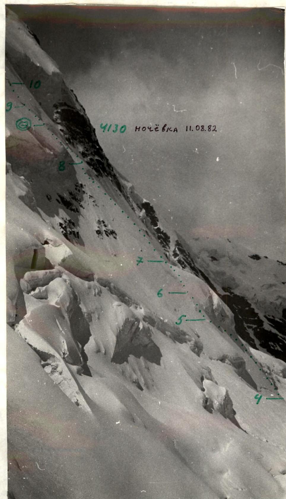
Profile of the middle part of the wall from the left. — route of the instructors' school team. August 13, 1982, 14:00. Point 3. Distance 2.5–3 km. Height 3850 m. Lens: T-43 4/40.
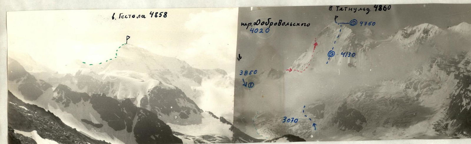
Photopanorama of the area. Point 5. July 21, 1982, from 9:00 to 10:00. Height of shooting point 3500–3600 m. Lens: Industar 50 3.5/50.
- Route of the instructors' school team 1982. Heights measured by altimeter are marked in blue. Heights taken from topographic maps are in black.
- Route of Bužek's group 1966.
- Shooting point of the profile from the left.
- Route of 3 category of difficulty to peak Gestola.
Tactical actions of the team
The ascent via the center of Tetnuld's North face proceeded in full accordance with the tactical plan presented to the judging panel and the Climbing Sports Committee (CSP). There were no deviations.
The determining factors were:
- Ensuring complete safety
- Speed of passage.
Considering that the upper section of the wall begins to be illuminated at 8:00 and around 13:00–14:00 there is some danger of falling ice, a movement schedule was chosen for nighttime and morning. During reconnaissance and observation of the route, a diagram of snow and ice avalanches was compiled. It was found that there were no signs of avalanches on the route itself. According to reconnaissance, there was a safe place for an overnight stay in the middle part of the wall, where the group planned to arrive by 12:00. Setting out at 1:00 AM from the base camp under the route, the group maintained a good pace and overcame:
- a snow-ice slope,
- a steep ice gully,
- an ice ridge bypassing the "island",
and reached a more gentle part, where they moved simultaneously and began to head towards the planned overnight stay "Glaz" (Eye).
The work was organized as follows: the front pair moved with a change of leader, leaving safety pitons behind, and the following trio used them and passed them on to the front pair. The reception of the lower climbers in the trio was done on separate pitons through technical safety gear (see appendix, p. 9) simultaneously, which significantly increased the speed of movement.
The leaders in the pair and trio regularly changed to reduce fatigue:
- the leader in the pair changed every rope length,
- the leader in the trio changed every two rope lengths.
The climber on lower belay always had a shock absorber, which increased the reliability of the belay. In some areas covered with snow, snow anchors were used for belay, as the use of ice axes was ruled out due to the looseness of the granular snow with a depth of 30–35 cm. Maintaining a high pace, the group reached the overnight stay location by 11:30.
The next day, the same tactics were maintained until the "key" ice cornice closing the wall. By 10:30, the group was under it. The tactical scheme for passing the key section was as follows: the first climber, with a lightened backpack (only a down jacket inside), ascended using technical means (ice screws, hammer), while the others followed either on a double fixed rope with two jumar ascenders or with top belay using a fixed rope. The first 90 m of ice with a steepness of 70°–80°, where a combination of ice screws and a hammer was used, were followed by 30 m of 95° hard, frozen ice. This section was extremely difficult to pass because the ice screws did not hold in the frozen ice, entering only 3–5 mm and breaking off ice fragments. It was necessary to first make a hole with the hammer's pick and only then insert the ice screw. The next 8 m were a firn overhang up to 110°. This was traversed by hammering in the axe handle and hanging étriers. The ascent was significantly complicated by deteriorating weather, snow grains, and a stormy wind. These conditions did not allow for thorough photography in these areas.
The entire group reached the pre-summit dome by 14:00. At 14:30, an overnight stay was set up in a bergschrund under the summit. Lack of visibility, strong wind, and snow did not allow for further movement.
On the morning of August 13, at 8:30:
- the summit was reached;
- descent followed down the southeast slope to the Tetnuld plateau;
- then through the icefall to the saddle between Gestola and Tetnuld peaks;
- from there, back to the base camp.
The backup group laid down a descent route through the icefall, and by 16:30, the ascent was completed.
There were no falls, injuries, or crevasse accidents. Communication with observers was maintained according to the schedule (see appendix, pp. 5–8).
| Section | Ice pitons | Rock pitons | Category of difficulty | Length (m) | Average steepness (degrees) |
|---|---|---|---|---|---|
| 0 | - | - | 3 | 60 | 45 |
| 1 | 4 | - | 3+ | 60 | 75 |
| 2 | 18 | - | 3+ | 250 | 50 |
| 3 | - | - | 3– | 90 | 35 |
| R4 | 22 | - | 3+ | 250 | 50 |
| R4A | - | - | 2– | 80 | 10–15 |
| 5 | 10 | - | 3– | 80 | 45 |
| 6 | 10 | - | 3+ | 50 | 70 |
| 7 | 46 | - | 3+ | 300 | 55 |
| 8 | 33 | - | 3+ | 220 | 60 |
| 9 | 24 | - | 3+ | 230 | 50 |
| 10 | 2 | 1 | 3– | 30 | 70 |
| 11 | 40 | - | 3 | 280 | 55 |
| 12 | 15 | - | 3+ | 90 | 80 |
| 13 | 10 | - | 5 | 30 | 95 |
| 14 | 6 | 8 | 100 | ||
| 15 | - | - | 2+ | 60 | 20 |
| 16 | - | - | 3– | 100 | 40 |
Notes to the table: For section 8: travel hours: 10:30; number of ice pitons: 193; number of snow anchors: 7. Total on the route: travel hours 24, ice pitons 232, rock pitons 1. Travel hours 13:30, ice pitons 109, rock pitons 1.

Description of the route by sections
The route begins at the lower part of the wall in the area of the left rock "island", which is bypassed on the left along an ice ridge, then passes:
- through an icefall,
- along a steep ice gully ~70°,
- to the second ice ridge, leading to an ice-snow slope above the "island" (sections R0–R2).
A characteristic feature of these sections of the route is the presence of porous, partially firnified ice. Movement with belay through ice screws is alternating, and in some places, simultaneous.
The wide slope above the "island" (section R3), 90–100 m long, with a steepness of 30–35°, and a plateau 80–100 m long, with a steepness of 10–15°, are the simplest part of the route.
Further, the route goes vertically upwards through a bergschrund along a vaguely expressed ridge of the ice wall. The first 120 m (4 rope lengths) are covered with a layer of snow 25–35 cm thick. The snow is granular, not compacted. Belay through an ice axe is unreliable, and clearing snow to screw in pitons is long and tiring. Here, belay through snow anchors was used. Where the snow was thinner, the ice was cleared of snow, and belay was done through ice pitons.
A large landmark on this section of the route is an ice ledge in the central part of the wall, which is located to the left of the direction of movement. To the right, the route is bounded by a vaguely expressed couloir on the ice wall.
The ice niche serves as an ideal place for an overnight stay on the route. It is a monolithic ice slab about 12–15 m high, at the base of which a natural pocket has formed, convenient for organizing a safe overnight stay. There are no other similar places on the route. Photo #9.
The exit from the niche is on the right side, along steep ice, and then straight up in the direction of the lower left part of the rock "paw" along an ice slope. In this part of the route, the ice becomes harder and more difficult to traverse. Movement is done in small zigzags to avoid being under each other. The first climbers in the rope team constantly use a combination of ice screws and a hammer or ice screws and an ice axe. Belay is done through ice pitons.
Having reached the lower part of the rock "paw" (section R10):
- cross it (6–8 m, 1 rock piton);
- move vertically upwards;
- exit onto a steep ice slope, leading under the base of the ice "roof".
On this section, the ice is without snow, and sections with hard ice are encountered more frequently. In photo #10, the shiny, almost polished ice is clearly visible. The lower part of the ice "roof" is a steep accretion ice, resembling rock "sheep's foreheads".
The ice is very hard:
- pitons are screwed in with great difficulty (sometimes on the second attempt),
- ice screws hold poorly,
- ice often breaks off in fragments.
The section is very psychologically tense. Movement is greatly complicated by a cold wind and snow grains that "pour" from the "roof". It is very cold.
It's especially hard for the last climber: the wind swings them on a freely hanging rope, as after removing the lower piton, they are thrown 2–3 m away from the wall.
In the middle part of the "roof", the ice is vertical, and the upper part (8–10 m) overhangs.
It should be noted that the upper part of the "roof" is dense firn, and ice pitons do not provide reliable belay. Here, it was necessary to:
- hammer in axe handles
- hang étriers
Movement of the others is done on étriers on jumar ascenders. The passage of the ice "roof" is possible on a wide section. Here, the limitation on the left is a triangular serac, and on the right, a ridge with cornices running from the summit. It is characteristic that the ice "roof" has no snow cornices along its entire length (200 m horizontally).
The complexity of passing this section lies in the fact that, in addition to the increasing steepness from 70 to 110°, the condition also changes - from hard, frozen ice, externally resembling rocks like "sheep's foreheads" at the base of the "roof", to the firn overhanging upper part.
After exiting onto the "roof", movement is along a gentle snow-ice slope in the direction of the summit. An overnight stay is set up in a pre-summit bergschrund. At night, there was a hurricane-force wind, the tent was covered with snow, and it had to be dug out twice.
Further, the route follows a simple slope to the summit. Descent from the summit is down the southern snow-ice slope to the Tetnuld plateau, then in a wide arc to the left, exiting onto the saddle between Gestola and Tetnuld. Further descent from the saddle is through an icefall, following the snow slopes of Gestola, to the Oush glacier and the base camp.
The return to "Bezengi" alpine camp follows the approach route through the V. Tsanner and Kel passes.
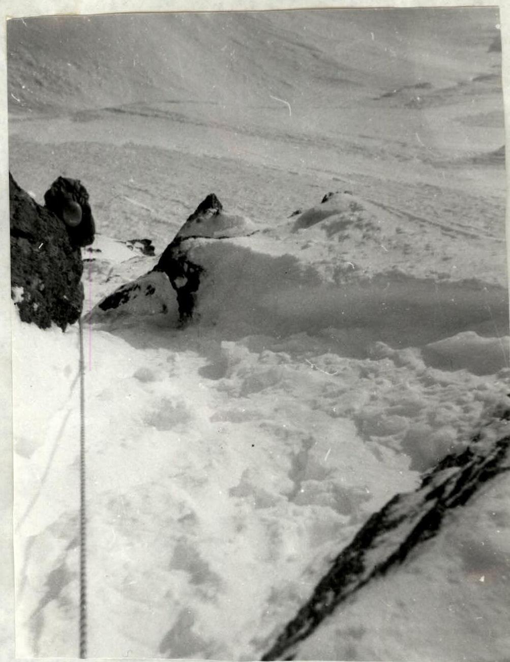
Photo #3. Section R10 — crossing the rock "paw". Shot from top to bottom from a distance of ~10 m. The second climber in the first rope team moves with top belay. Lens: T-43 4/40. Time ~5:30.
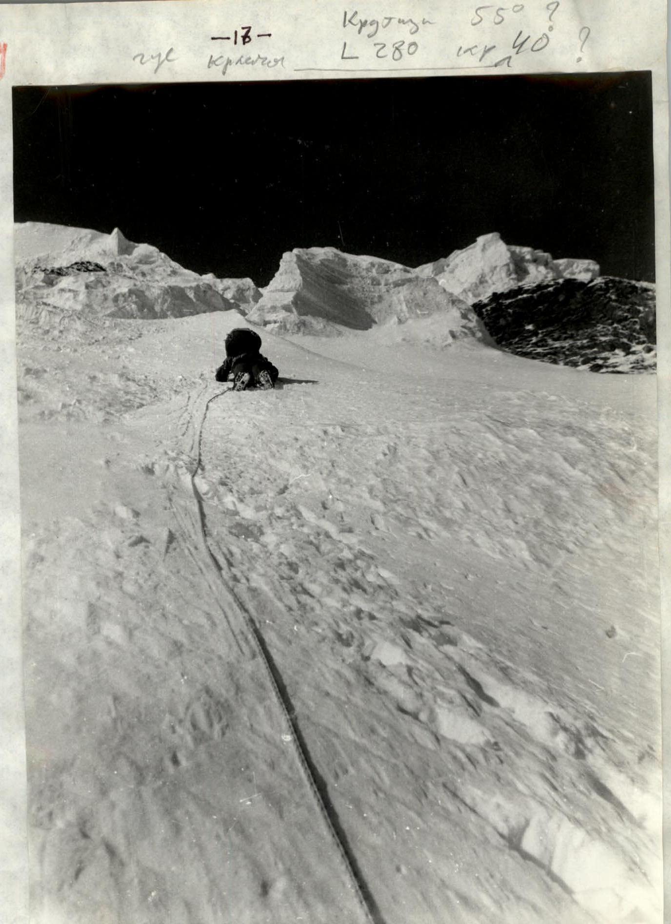
Photo #4. Beginning of section II. Hard ice is covered with loose snow 7–8 cm thick. The first climber moves with an ice axe and an ice hammer. Shot from below upwards from 15 m. Time ~8:30. Lens: T-43 4/40.
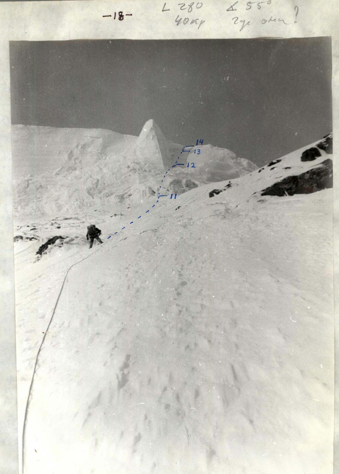
Photo #5. View from below upwards at the overhanging section of the route ("roof"). The triangular serac is passed on the right. Shot in the middle of section II. It is clearly visible that the steepness is such that the rope does not touch the ice in some places. The first climber stands, leaning back on the top belay, and prepares to receive the second. Shot at 9:00. Lens: T-43 4/40.
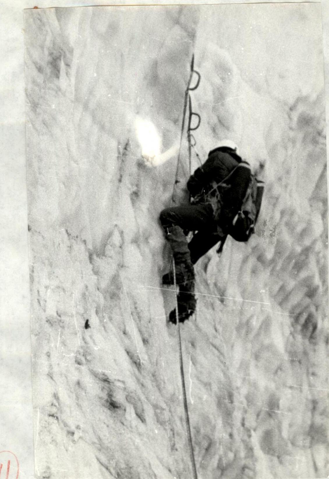
Photo #7. Middle of section R12. Organization of an intermediate belay point. The first climber moves with two ice screws and a hammer. The attachment of ice screws to étriers and harness is clearly visible. Shot from a distance of ~5 m from the left below. Lens: T-43 4/40. August 12, 1982. Time ~13:00.


Photo #8. In the right part, a couloir has been swept by an avalanche. It is visible that the team's path is safe. The overnight stay location "Glaz" (Eye) and the second rope team approaching it are clearly visible.
- Shooting point: R4
- Time: 02:20
- Date: August 2, 1982
- Height: 3420 m
- Lens: Tair-II 2.8/133
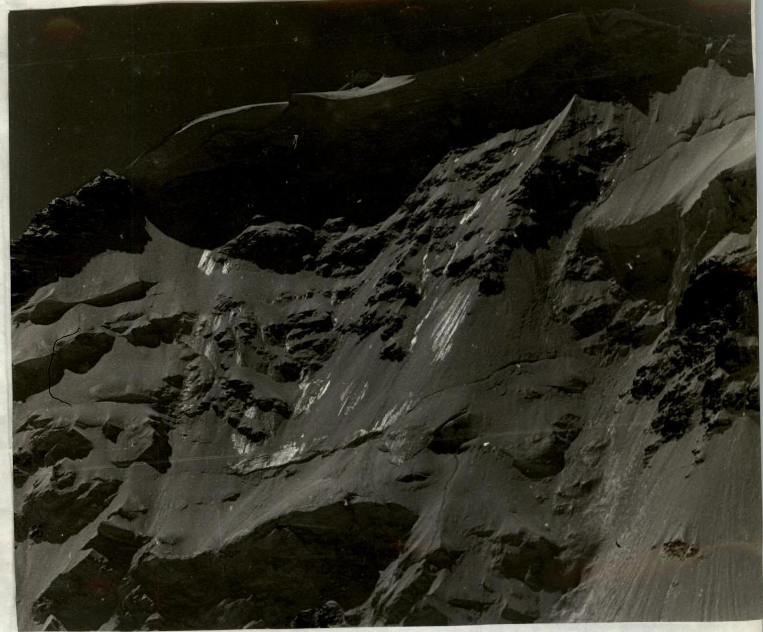
Photo #10. Upper half of the route. Sections of bare ice, the overnight stay location, and the team's path are clearly visible.
- Shooting points: R4
- Time: ~12:00
- Height: 3420 m
- Lens: Tair-II 2.8/133