Climbing Passport
- Snow and ice class.
- Central Caucasus, Dykh-Su valley.
- Peak Aylama via the center of the North face.
- Proposed category: 5B, first ascent.
- Elevation gain: 1475 m, route length — 2333 m.
Average steepness of main sections — 53°. Including 6th category sections up to 95° — 27 m.
-
Pitons driven: rock — 5 bolt hangers — 3 ice — 46/II
-
Team's total climbing hours: 31, days — 3.
-
Overnight stays: 1st and 2nd — lying down, both tents were standing side by side.
-
Team leader: Mukhortov Mikhail Veniaminovich, Candidate Master of Sports Team members: 2. Ivanov Nikolai Rufovich, Master of Sports 3. Bolonin Vladimir Petrovich, Candidate Master of Sports 4. Gerstein Alexander Semenovich, Candidate Master of Sports 5. Andrienko Viktor Borisovich, Candidate Master of Sports 6. Sobolev Nikolai Mikhailovich, Candidate Master of Sports
-
Coach: Zhirnov Viktor Vasil'evich, Honored Coach of the RSFSR.
-
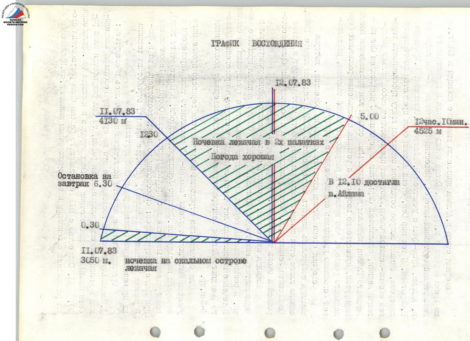
Departure to the route: July 11, 1983. Summit: July 12, 1983. Return: July 13, 1983.
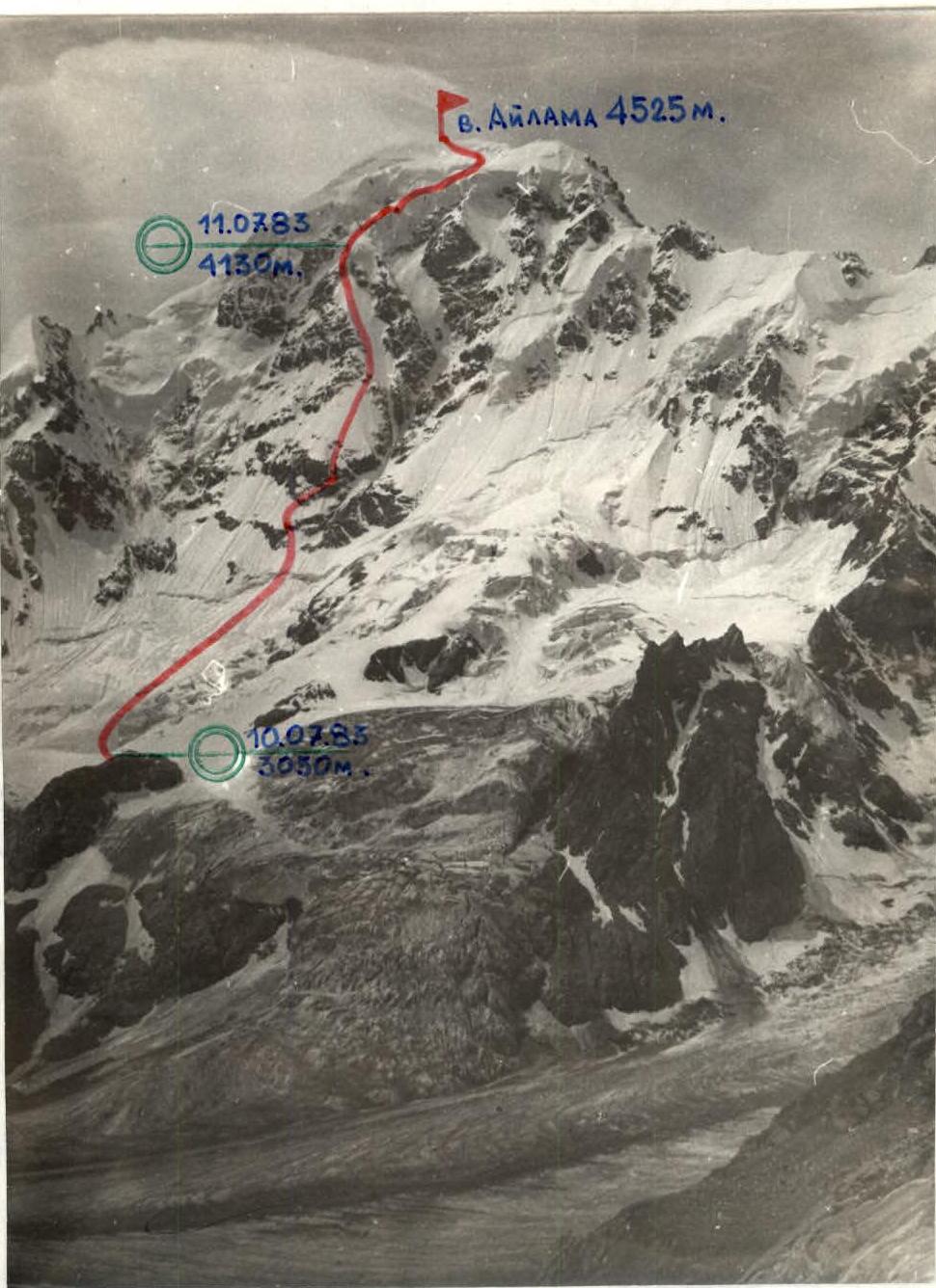
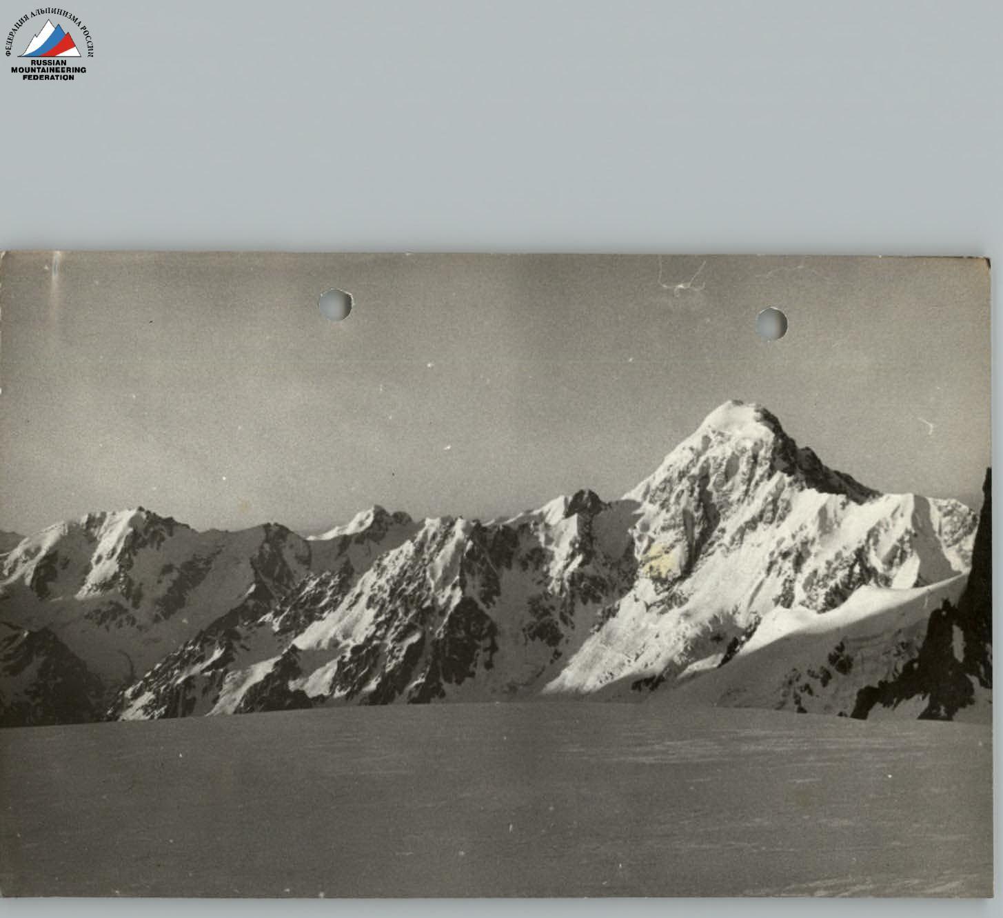
Photo # 1. General photo of the North face of peak Aylama. Taken from the Dykh-Kotiu-Buğan glacier (point # 2) on July 9, 1983, at 12:30 from a distance of 2 km. Lens T-22, F=4 cm.
 www.alpfederation.ru↗
Aylama, 1983 team leader Mukhortov
The North face of Aylama attracted the team's attention in 1961, during the descent from peak Krumkol. The face is very beautiful and represents undoubted sporting interest. Expeditions to Aylama and Nuam-Kuam in the 1950-60s included:
- V. Ivanov,
- A. Osintsev,
- I. Kudinov,
- Yu. Saratov.
Since then, the North face of Aylama has been the subject of constant interest, but the issue remained open due to the problematic upper snow and ice section, which is a heavily broken glacier sliding down from the summit in barriers. With the emergence of the Snow and Ice Class, an additional incentive appeared for climbing new routes, and the technique for overcoming various forms of ice relief significantly improved, leading to the development of new tactics for safely climbing snow and ice routes.
The team was well-trained. The main members had repeatedly participated in Championships of Leningrad, Caucasus, and Central Sports Club, and had won prizes. In the autumn-winter period, they conducted joint training on rocks. For several years, team members participated in the Winter Outreach Camp of the Leningrad Sports Committee, where they made ascents of 4th-5th category difficulty.
To organize belays and overcome the upper problematic section, they prepared:
- "ice fi-fi" of various types (tested on ice in Sabline, Leningrad region, in March of that year);
- experimental snow pitons (developed by the Safety Committee at the Instructors' School; tested during the ascent to peak Dykh-tau as part of the Caucasus Championship);
- firn pitons.
They also practiced the technique of using them on slopes of varying steepness.
Organizational aspects of preparation included:
- Since such an ascent is essentially a small expedition to a rarely visited area, a plan was developed for the School's work and interaction between training units and the team (see Appendix 2).
- Together with the Bezengi Region Sports Club, a radio communication scheme was developed with primary and backup channels (see Appendix 3).
Tactical Actions of the Team
The tactics for ascending peak Aylama included the following:
- thorough preparation for the ascent;
- coordination of plans between the School and the team;
- reliable radio communication and its duplication (see appendices 2, 3);
- a two-day approach, during which the team did not exhaust their strength;
- night passage of the lower ice and snow section;
- preliminary selection (based on available information) of convenient lying-down bivouacs, contributing to the restoration of strength;
- light and calorie-rich nutrition, allowing for quick recovery;
- use of adaptogens for the same purpose;
- decision to go on the route with six members, reducing the overall weight and increasing the speed of movement;
- interaction between rope teams and interchangeability of participants;
- high speed of passage (one of the elements ensuring safety on the route), requiring mandatory change of lead;
- passage of sections of 3rd-4th category difficulty independently on pitons left by the first rope team, sections of 5th-6th category — using fixed ropes (Photo # 6);
- use of modern snow and ice equipment and new techniques for overcoming various forms of snow and ice relief (Photos # 8-12);
- consideration that the safest path down from the summit goes along a long snow-covered rock ridge of 3rd-4th category difficulty.
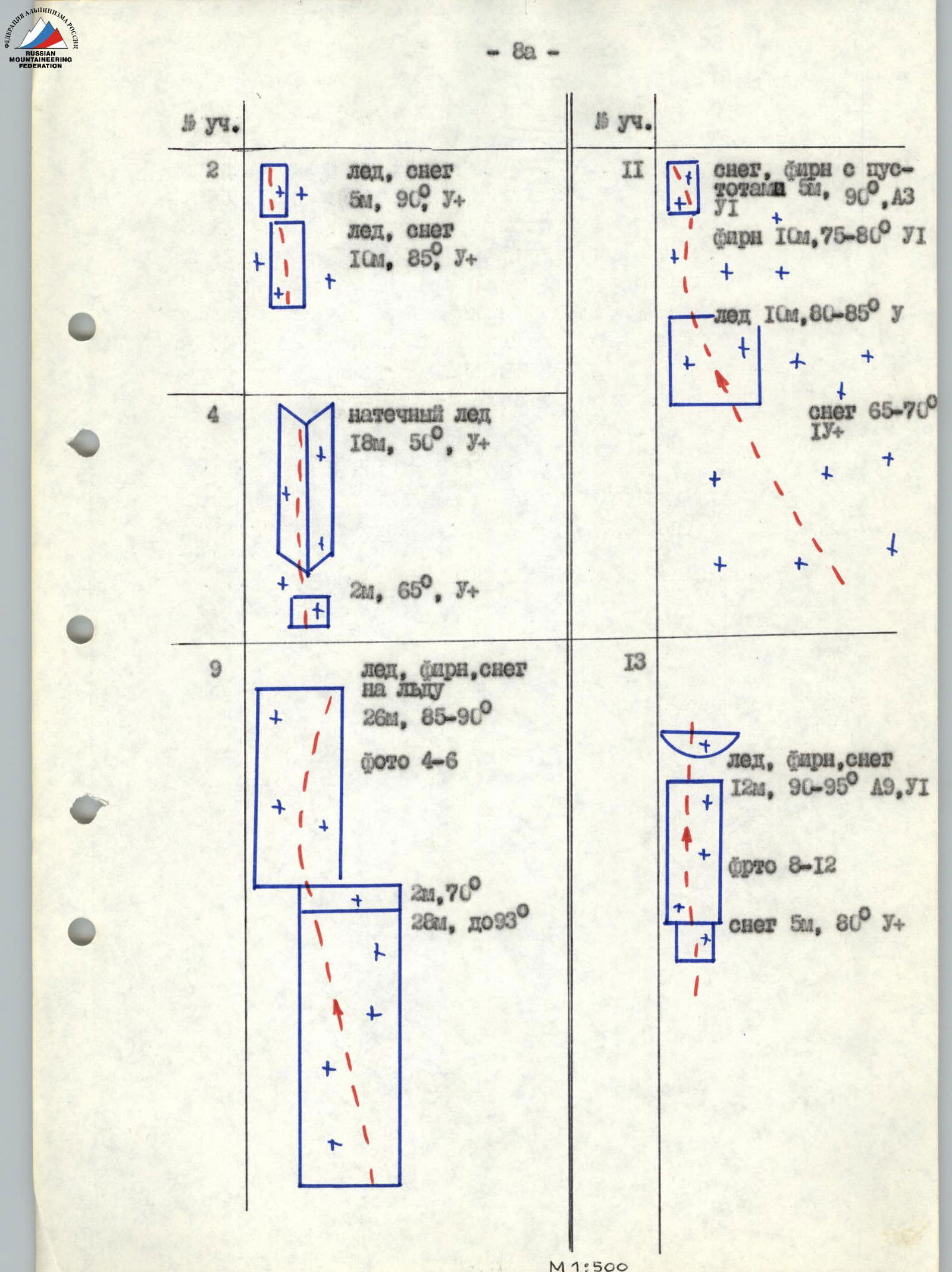
The problem with the route is the upper section. Essentially, it is a huge, heavily broken, non-uniform icefall. Sections # 9, 11, 13 represent a kind of "layer cake" of snow, firn, and ice, including:
- hard and porous ice;
- firn of varying steepness;
- compacted snow;
- soft firn;
- drifts of fresh snow.
Such diversity of relief conditions required the team to have:
- good preliminary preparation;
- a certain set of technical means (firn pitons, "ice fi-fi" of different types, experimental snow pitons, ice axes used as artificial points of support);
- technical skills and — most importantly — psychological readiness to quickly change actions for organizing belays and the ability to dynamically change methods of passage (Photos # 8-12).
The team followed the route without deviating from the tactical plan. There were no falls or injuries.
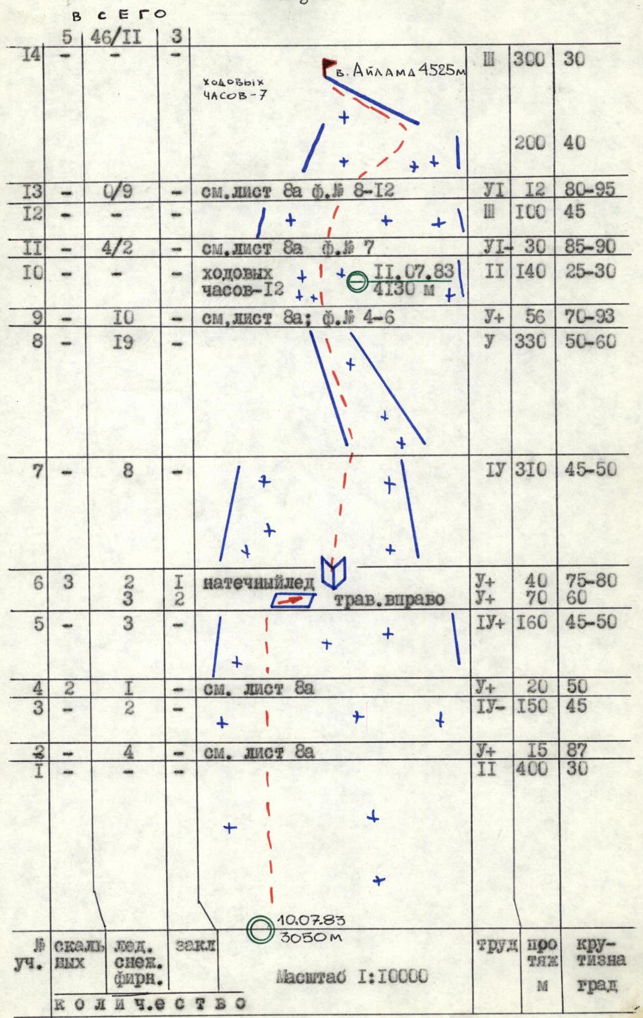
The route begins at a convenient and safe overnight stay on a large rock outcrop near the North face of peak Aylama. It's better to arrive at the bivouac at least a day before starting the route to mark landmarks for confident movement across the glacier and carefully examine rock sections 4 and 6, as they will be climbed at night. Departure from the bivouac at 0:30. The bergschrund is crossed using an ice axe, ice hammer, and "fi-fi". As they approach the rocks, the steepness of the ice increases to 45°. The first rock belt is a rock gully filled with ice. Difficult climbing is complicated by difficulties in organizing intermediate belays, as the ice is not always thick enough, and it's necessary to find cracks in the rocks. Headlamps worn by all team members are helpful. Further, they climb straight up through snow at 40-45° to the second rock belt. Belays are organized using experimental snow pitons on ice axes, as recommended by the Safety Committee at the Instructors' School that season. Then, they traverse right along a snow-covered ledge-plateau for 70 m to a "corner" where a safe belay point can be established for the second half of R6. From there, they climb two rope lengths of complex climbing up a wide rock gully (80°) filled with ice. Belays are organized through ice screws and rock pitons along the edges of the gully. At the exit, fixed ropes are anchored to a snow piton. Further movement is at maximum pace with constant change of rope teams and lead climbers on a snow and ice slope up to 55°. Belays are organized through snow pitons and ice screws. At the boundary between sections R7-R8 (entrance to the couloir), they stop to rest and have breakfast. Section R8: the path goes under the protection of a rock overhang along an ice couloir with monotonously increasing steepness (up to 60°). For about half the distance, there is a thin layer (5-7 cm) of snow on the ice, further on — ice. Movement on such steep ice relief is quite difficult physically and technically, but with modern ice climbing techniques and belay organization on ice, the section is overcome fairly quickly. Rope teams move independently on pitons left by the first team. While the first team rests, the third team, having collected pitons, passes by and moves ahead. There is a change of lead within the rope team.
Section R9 is a steep, two-tier ice drop. Length — 56 m. The ice is monolithic — no cracks or breaks. Small icicles hang from overhanging areas (Photos 4-6), as the drop is sunlit. Climbing is very difficult, similar to routes in ice climbing competitions held on Kashka-tash glacier, but this is at an altitude over 4 thousand meters. The shortest path to the bend is straight up, slightly to the left. The path is logical and safe. To the right, the overhang is more extensive; it's not possible to go along the left part of the counterfort, as the depression to the left of the ice drop is a natural collector of avalanches. The counterfort itself protrudes far forward relative to the entire ice and snow cap of the summit (Photos 2, 3). N. Ivanov climbs the first, somewhat overhanging tier of the drop (carrying only personal gear in his backpack). Two "fi-fi" are used in combination with an ice hammer. Behind the overhang is a reception point. Using clamps, the Andrienko-Bolonin rope team ascends on the fixed ropes laid by Ivanov and moves up to the end of the section. Belays are organized using ice screws, which are passed to the first team as they are extracted. The second tier is a sheer drop, but without overhang (Photo 2). On the pad R10, they have a bivouac. The second rope team processes the start of R11 (Photo 7). On July 12, 1983, the Mukhortov-Andrienko rope team departs from the bivouac at 5:00 and sets up fixed ropes on R11. The section has a complex structure, which causes difficulties in passage. Over the length of one rope, steep loose snow (65-70°) gives way to hard ice (0.5 m, 80-85°), then to hard firn (10 m, 80°), transitioning into soft firn and snow covered with a thin (2-3 cm) crust frozen overnight, and an intricate network of icicles hanging from small ledges melted out in the snow and firn (4.5 m, 90°). The upper part is climbed by digging out steps and using snow ledges and cavities. Elements of "Zal'tsut" are used. Belay and support points are made using snow and firn pitons, ice axes driven into the snow with the pick, and, at the very end, on exiting, an ice screw screwed into a strong, wide, short icicle. The path is unambiguous, as to the right there is an overhang, and to the left — a deep depression. Further, they climb a snow slope 100 m, 45° to R13, which is a fault in the central "claw" of the glacier sliding from the summit (Photo 2). Examination of the fault showed that to the right it leads to rock drops of the North face (Photos 2, 3), and to the left it drops into the already familiar depression (Photos 3, 8). The only option is to advance "head-on" into the overhanging wall of the fault, confirming fears expressed during observations from Dykh-Kotiu-Buğan glacier. After a brief discussion, Ivanov moves forward. The entire arsenal of technical means and techniques for overcoming overhanging snow and ice relief is used. The section is similar in structure to the upper part of R11, i.e., a "layer cake" of ice, firn, and snow of varying density, but it is much steeper from start to finish (95°) and ends with a one-and-a-half-meter cornice of soft snow. Moreover, it's a clear, sunny morning, and the snow is becoming softer by the minute. The section is of maximum difficulty. The nature of the section and the technique of its passage are clearly visible in the photographs (8-12). Section R14 does not present particular difficulty.
Attention should be paid to the descent, which initially follows the West ridge (where an overnight stay is desirable), then along the long North ridge adjacent to the West ridge between peak Aylama and peak Nuam-Kuam. This is a route of 3rd-4th category difficulty, passing along a heavily destroyed snow-covered rock ridge. For organizing rappels and sport climbing, it's necessary to have:
- a sacrificial rope;
- a sufficient set of rock pitons and chocks.
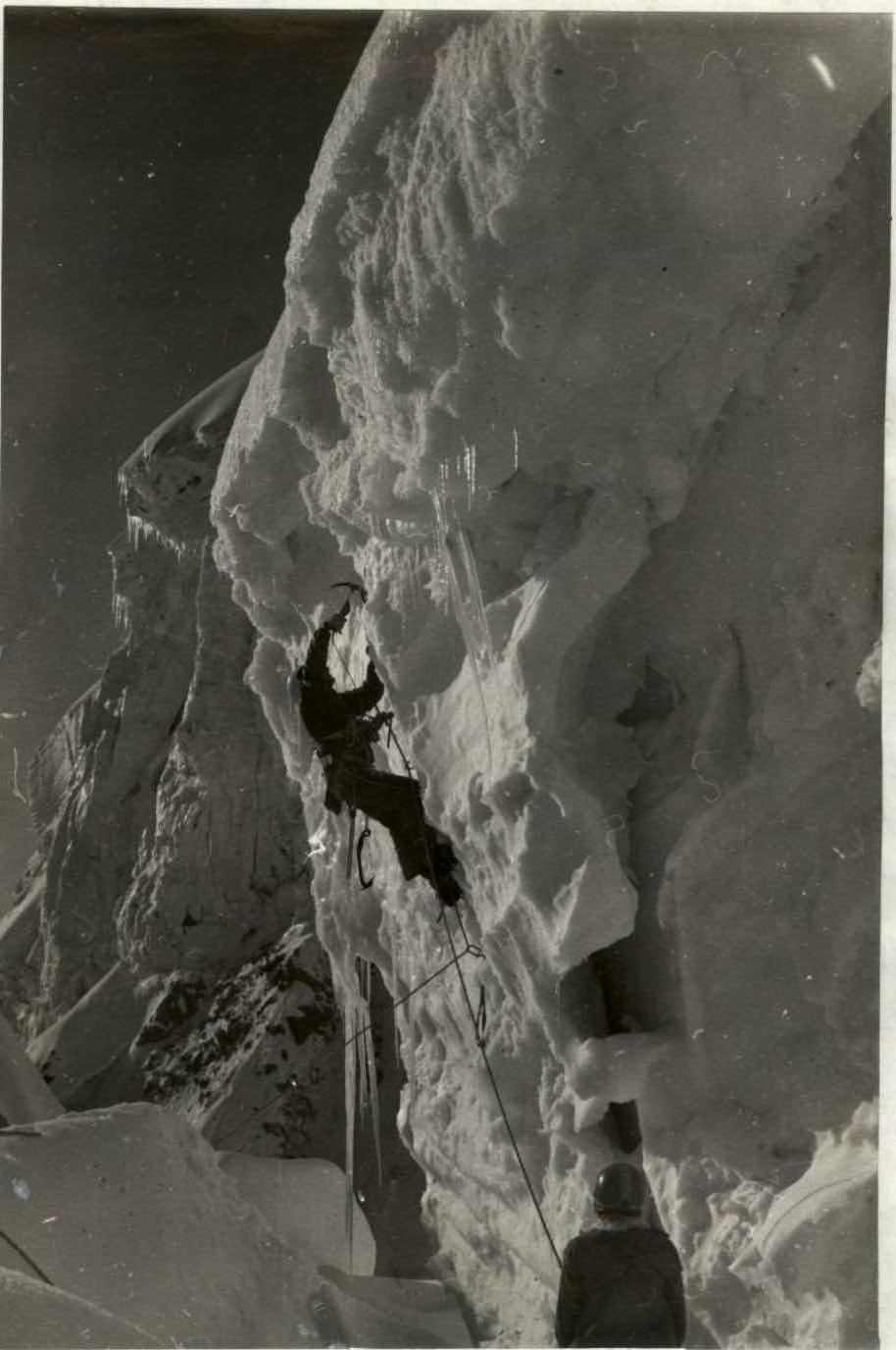
Photo # 6. Passage of the overhanging firn wall (section 13). Clearly visible:
- the overhang of the wall with a cornice of fresh snow;
- behind the icicle, a deep depression is visible, protecting the route from avalanches from the upper cap of the summit.
Taken on July 12, 1983, at 8:10. Lens T-22, F=4 cm.
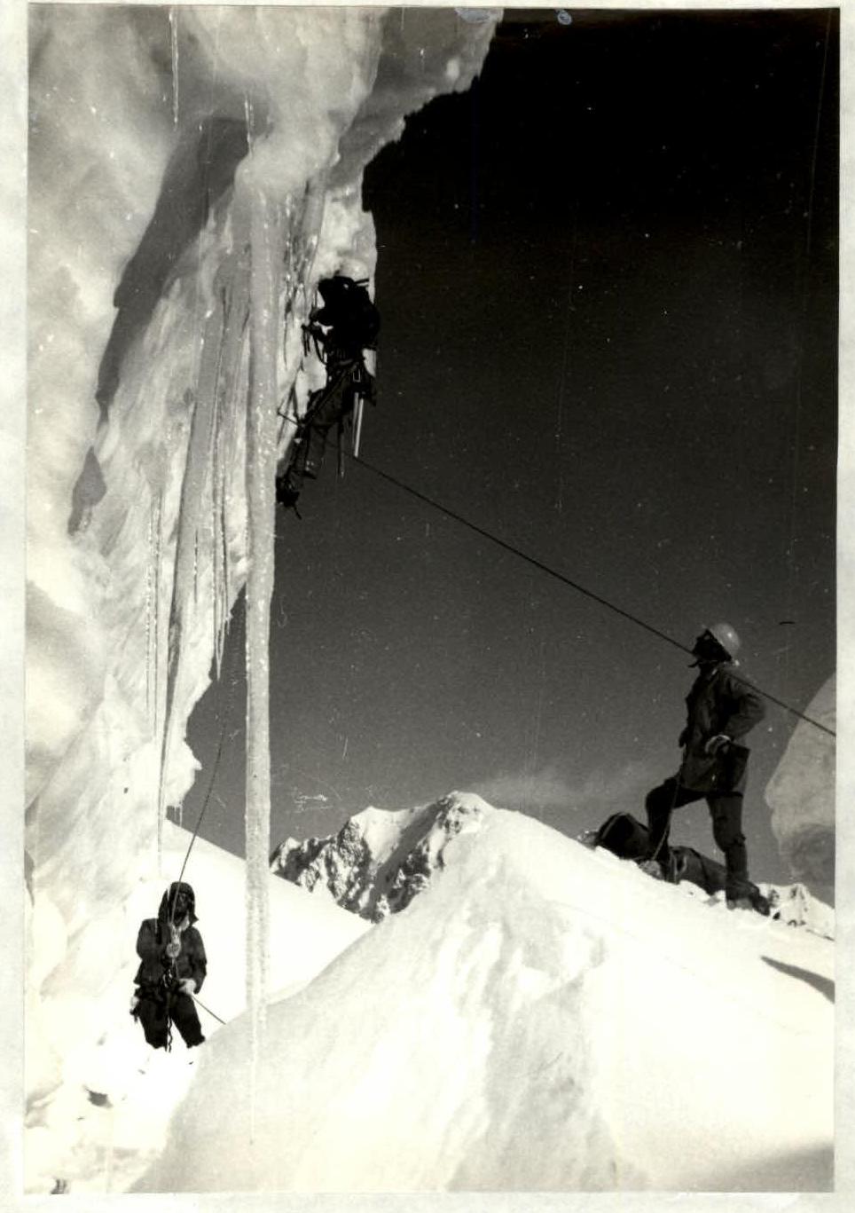
Photo # 9. Passage of the overcrowing ice and snow-firn wall continues. Shkhara is visible in the background. Taken on July 12, 1983, at 8:45. Lens T-22, F=4 cm.
In 1983, a team of coaches from the All-Union Instructors' School made an ascent to peak Aylama via the center of the North face. This is the second route on Aylama from the North. The first ascent was made by A. Osintsev and V. Ivanov in 1957, classified as 5B category difficulty, but there is no description in the climb registry. According to consultations, the 1983 route does not coincide with it. Both routes on Aylama from the North are combined climbs of increased difficulty, compounded by a technically complex descent along a narrow snow and ice rib and steep rocks.
The route via the center of the North face is climbed in three days with an overnight stay on the ascent and on the descent. In all parameters, its technical and tactical complexity corresponds to the 5B category difficulty and is comparable to control and test routes of 5B category in the Bezengi region. This assessment coincides with the opinion of the region's Sports Club.
Based on the above, we consider it necessary and request that the materials for this route be reviewed and it be included in the classification table of peaks as a combined route of 5B category difficulty, in accordance with the proposal of the team that climbed it and the opinion of the Bezengi region Sports Club.
Team Coach Zhirnov V.V.
Head of the Bezengi Region Sports Club Saratov Yu.S.
Captain of the Instructors' School Team Mukhortov M.V.