
REPORT
ON THE ASCENT OF THE NORTH FACE OF PIK SHCHUROVSKOGO
Central Council of the Sports Society "Avangard"
Kiev — 1962
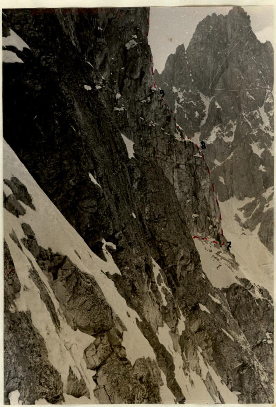
Profile of the lower part of the large rock island. Sections of the wall R7–R10. Photograph taken by V. Bocharov during the ascent of the northeast wall of Pik Shchurovskogo on July 14, 1962.
Introduction
Pik Shchurovskogo (4259) is located in the Central Caucasus and is situated in the ridge that borders the Shkheldy glacier from the northeast.
The first ascent to the peak "4259" was made in 1916 by Ya.I. Frolov, a member of the Russian Mountain Society expedition, who named the unnamed peak after the Russian mountaineer V.N. Shchurovskogo. The ascent was made via the simplest path from the Ushbinskoye plateau.
In the post-war years, Soviet mountaineers began to successfully climb peaks via the most complex, wall routes.
The steep north faces of Pik Shchurovskogo have long attracted mountaineers.
The team of the Sports Society "Spartak" led by the Honored Master of Sports of the USSR V.M. Abalakov made two first ascents to Pik Shchurovskogo: in 1947, they climbed the northwest wall, and in 1953, they climbed the more complex northeast wall. Both ascents were recognized as the best ascents of the 1947 and 1953 seasons.
The combined team of the Central Council of the Sports Society "Avangard", which had repeatedly participated in the USSR mountaineering championships, decided in 1962 to climb the north face of Pik Shchurovskogo via a logical route abounding in complex sections.
The assault route passed between the northwest and northeast walls of Pik Shchurovskogo.
I. Information about the sports group
a. Composition of the assault group
The combined team of mountaineers of the Central Council of the Sports Society "Avangard" in 1962 included individuals from the 1961 gathering, which took place in the Bezengi region. A young capable mountaineer, Nikolai Mashchenko, was included in the assault group for the first time. Since 1959, he had been part of the second team and by 1962 had completed a number of complex ascents to peaks of the 5th category of difficulty:
- Ullu-tau via the slab 5A category
- Pik Shchurovskogo via the northwest wall 5B category
- Ushba southern 5A category
- Koshtan-tau via the eastern ridge 5A category
- western Mizhirgi 5A category
- Dykh-tau from the south 5B category
- eastern Shkhelda 5A category
- and others.
All members of the assault group were registered to participate in the competition for the best achievement of the 1962 season in the class of technically complex ascents. The registration was submitted in the established form in accordance with the requirements specified in § VII, paragraphs 28–32.
In the submitted registration, B. Subartovich was entrusted to lead the assault group. However, due to heavy instructional workload at the "Elbrus" alpine camp, he was unable to prepare for the planned ascent.
Preparing the ascent to Pik Shchurovskogo was entrusted to the Master of Sports of the USSR L. Kensitskii, the deputy head of the assault group. Kensitskii was appointed as the leader of the assault group.
Table 1

The team believed that such a replacement of the leader could negatively affect its participation in the competition. In this regard, before departing on the route, a letter was sent to the representative of the USSR Mountaineering Federation, Honored Master of Sports of the USSR P.S. Rototaev, requesting to withdraw the team from the competition.
P.S. Rototaev did not agree to withdraw the team from the competition, and we decided to submit our report for consideration by the judging panel of the USSR Mountaineering Federation.
The composition of the assault group is given in Table 1.
b. Composition of the observation group. Organization of communication and observation
The observation group consisted of 2 people: V. Simonova and I. Zaseda.
The observation group had:
- a set of flares for light signaling,
- a telescope with 20x magnification,
- binoculars.
The observation group was tasked with:
- Continuously monitoring the movement of the assault group along the wall, recording the time taken to pass the route sections in the observation log.
- Regularly exchanging signals.
- In the event of an accident to the assault group, notifying the Elbrus region KSP and the leadership of the "Elbrus" alpine camp.
Communication with the assault group was carried out using flares. Communication was conducted according to the developed instructions (see "Appendix").
II. Organizational and tactical plan of the ascent
2. Organizational plan of the ascent
The organizational plan provided for a systematic, sequential preparation of our team for the planned ascent, taking into account the gradual increase in load and allocating sufficient time for observing the wall.
The plan was presented to the representative of the USSR Federation in the Elbrus region, Honored Master of Sports of the USSR P.S. Rototaev. During the preparation for the wall assault, we made the following adjustments to this plan: before the ascent to the Central MNR peak (4B), we climbed the Cheget-kara peak (2B).
2. Tactical plan of the ascent
a. Choosing the time to pass the route sections
It was decided to start the route early in the morning when the northeast wall of Pik Shchurovskogo was not illuminated by the sun.
The passage of the large rock island was planned for the second half of the day, and the ascent along the wall behind the "gendarme" was planned for the morning.
This distribution of departure and movement times on the route fully justified itself. The group was never caught in rockfall.
b. Distribution of load by days. Choice of bivouacs
The load was distributed based on the planned locations of the bivouacs. Good organization of the bivouacs significantly restores the working capacity of the climbers. When distributing the time taken to pass the route sections, the complexity of individual sections of the wall was taken into account.
The first bivouac was planned at the base of the triangle on a well-visible snow-covered ledge from below.
According to our plan, we were to start the wall later than the group led by Mikhail Khergiani. We asked M. Khergiani to examine the relief behind the "gendarme" during his ascent. After completing his ascent, he informed us that there was a small depression (5–8 m) behind the "gendarme" and a snowy ridge leading to the wall, where it was possible to set up a good bivouac. This was where our second bivouac was planned.
The organization of this bivouac was planned at a relatively short distance from the first. We did not know if it was possible to bypass the "gendarme" from the left. Climbing the "gendarme" head-on was considered to be significantly difficult and would have taken a lot of time.
On the wall of the "bastion", we planned a third bivouac, which we intended to set up if the ascent along the upper part of the wall proved too complex.
The distribution of the load by days was as follows: on the first day, the group "worked" on the route from 5:30 am to 11:40 am, i.e., 6 hours and 10 minutes. Then, there was a one-hour break for lunch, after which the group ascended for another 6 hours and 20 minutes, reaching the ledge at 18:50. Setting up the bivouac did not require much time or effort, and by 20:00, everyone was asleep.
On the second day, the group ascended the wall from 6:30 am to 1:00 pm (6 hours and 30 minutes). After lunch, which lasted one hour, L. Kensitskii and V. Monogarov went to process the route, which took 3 hours and 30 minutes.
The remaining participants worked on setting up a comfortable platform.
On the third day, due to heavy snowfall during the night, the group started the route at 9:00 am. They ascended for 9 hours. They reached the summit at 18:00. The descent took 3 hours.
Thus, the group "worked" on the route:
- first day — 12 hours and 40 minutes,
- second day — 9 hours and 40 minutes,
- third day — 9 hours.
The entire route was completed in 31 hours, not counting the time taken for lunch breaks and the descent from the summit.
This time allocation justified itself. All participants felt very good on the route and after completing the ascent.
For subsequent groups, it can be recommended to set up the second bivouac on the snow-covered rock shoulder, above 70–80 m from the top of the "gendarme".
VII. Actions of the team in changed circumstances
During the second night on the "gendarme", it snowed throughout the night. The rocks were heavily snow-covered.
In the morning, it cleared up slightly, visibility improved, and the group decided to continue the ascent along the wall.
The route processed the previous day significantly facilitated the start of the ascent along the snow-covered rocks.
If we had not processed part of the route in advance, passing this section in the circumstances that arose would have been extremely hazardous.
TABLE
Route of the ascent of the north face of Pik Shchurovskogo by the group of the Central Council of the Sports Society "Avangard"
Height difference of the route — 1040 m Including complex sections: 700 m, including traverses along the wall Steepness of the route — 70° Including complex sections:
- 70°–75° — 410 m
- 80°–85° — 290 m
The route was completed in 31 hours of walking time.
| Date | Sections passed | Average steepness of the section, degrees | Height of the section, m | By relief character and advancement features | By technical difficulty | By movement method | By weather conditions | Departure time | Time of stops at bivouacs | Walking hours | Rock | Ice | Drilled | Weight of daily ration |
|---|---|---|---|---|---|---|---|---|---|---|---|---|---|---|
| First day of assault | ||||||||||||||
| 14.VII | R0–R1 | 45 | 70 | Compacted snow, ice and snow-filled bergschrund | easy | via ice axe | clear | 20 min. | 700 grams | |||||
| -"- | R1–R2 | 75 | 20 | Ice wall of the bergschrund | complex | piton | 40 min. | 2 | ||||||
| -"- | R2–R3 | 40 | 20 | Traversing right along snow and ice to the lower part of the rock island | medium complexity | via ice axe, piton | 20 min. | 1 | ||||||
| -"- | R3–R4 | 50 | 70 | Ascent along broken, fragmented rocks to the start of the couloir | medium difficulty | via outcrops, piton | 40 min. | 3 | ||||||
| -"- | R4–R5 | 60 | 30 | Crossing the couloir along snow and ice. Possibility of rockfall from above | piton | 20 min. | 2 | |||||||
| -"- | R5–R6 | 80 | 10 | Exit from the couloir along fragmented rocks | difficult | piton | clear | 20 min. | 2 | |||||
| -"- | R6–R7 | 75 | 120 | Traversing right along ice-covered rocks at the base of the wall. Possibility of rockfall from above | piton, outcrops | -"- | 2 hours | 9 | ||||||
| -"- | R7–R8 | 70 | 90 | Ascent along the wall upwards, rocks are firm, местами с малым количеством зацепок. Exit to a snow-covered ledge | -"- | piton | -"- | 1 hour 30 min | 8 | |||||
| -"- | R8–R9 | 60 | 15 | Traversing left upwards along an inclined snow-covered ledge | medium difficulty | from piton | -"- | 10 min | 1 | |||||
| -"- | R9–R10 | 80–85 | 50 | Ascent along the wall upwards towards the rock "cube". Rucksacks are pulled up | very difficult | -"- | -"- | 2 hours | 12 | |||||
| -"- | R10–R11 | 65–70 | 130 | Ascent along the wall upwards towards the overhanging rock "zhab". Rocks are smooth, местами с малым количеством зацепок | difficult | -"- | -"- | 2 hours | 12 | |||||
| -"- | R11–R12 | 75 | 40 | Ascent along the wall upwards to the left of "zhab". Rocks are firm, smooth | -"- | -"- | -"- | 1 hour | 4 | |||||
| -"- | R12–R13 | 60 | 40 | Ascent along a weakly expressed rock ridge, to the left of the snowy couloir, rocks are fragmented | medium complexity | piton, via outcrops | -"- | 30 min | 3 | |||||
| -"- | R13–R14 | 30 | 40 | Traversing right along rocks and snow to the top of the large rock outcrop — "zhab" | easy | piton | -"- | 18 hours 20 min | 2 | Ice platform carved | ||||
| Total for the day | 530 | 12 hours 59 min | ||||||||||||
| Second day of assault | ||||||||||||||
| 15.VII | R14–R15 | 70 | 45 | Ascent upwards to the left of the steep red rock along fragmented rocks | difficult | piton, outcrops | light cloudiness | 6:30 am | 20 min | 3 | 700 grams | |||
| -"- | R15–R16 | 80 | 20 | Traversing along a narrow shelf to the left | -"- | -"- | -"- | 20 min | 2 | |||||
| -"- | R16–R17 | 60 | 5 | Ascent along fragmented rocks to a snow-covered ledge | medium difficulty | piton | -"- | 10 min | 1 | |||||
| -"- | Attempt to bypass "gendarme" from the left. Descent by sports method 40 m and traversing to the left. Bypass not found. Start of the couloir is filled with ice. Ice wall of great steepness with large, heavily iced-over hanging blocks at the top of the couloir. To the right — a smooth wall of "gendarme". Ascent to the ledge via the descent path | 1 hour 3 min | ||||||||||||
| -"- | R17–R18 | 85 | 30 | Ascent to "gendarme" from the left along firm rocks with few handholds | difficult | piton | light cloudiness | 1 hour 40 min | 7 | |||||
| -"- | R18–R19 | 80 | 80 | Ascent upwards — to the right along monolithic rocks of great steepness to the top of "gendarme" | 1 hour 50 min | 19 | On the top of "gendarme" | |||||||
| Route processing | Lunch 1 hour | |||||||||||||
| -"- | R19–R20 | 40 | 10 | Ascent upwards along a snow-ice bridge to the base of the "bastion" wall | medium difficulty | piton | -"- | 30 min | 1 | 1 | ||||
| -"- | R20–R21 | 80 | 15 | Traversing left at the base of the wall along ice and embedded rocks to the edge of the ice couloir | difficult | -"- | -"- | 30 min | 3 | |||||
| -"- | R21–R22 | 60 | 20 | Crossing the couloir to the left downwards onto the front teeth of crampons | medium difficulty | -"- | -"- | 10 min | 1 | |||||
| -"- | R22–R23 | 60–70 | 20 | Ascent along broken, step-like rocks to the left upwards | difficult | -"- | -"- | 50 min | 4 | |||||
| -"- | R23–R24 | 50–60 | 20 | Ascent along iced-over slabs to the left upwards. In the upper part, there are no cracks for pitons | -"- | -"- | -"- | 1 hour | 4 | 1 | ||||
| Descent along the ascent path to the bivouac site | ||||||||||||||
| Total for the day | 210 | 9 hours 40 min | 48 | 1 | 1 | 700 grams | ||||||||
| Third day of assault | ||||||||||||||
| 16.VII | R28–R29 | 70 | 30 | Ascent upwards to the right 80 m along snow-covered, step-like, broken rocks | difficult | via outcrops, piton | fog | 45 min | 4 | |||||
| -"- | R29–R30 | 10 | Traversing 60 m to the right upwards along a heavily snow-covered ledge | medium difficulty | -"- | -"- | 20 min | 2 | ||||||
| -"- | R30–R31 | 75 | 35 | Ascent upwards along steep, местами fragmented, snow-covered rocks. Ascent to a narrow niche | difficult | piton | -"- | 40 min | 4 | |||||
| -"- | R31–R32 | 80–70 | 25 | Very complex traversing 4 m to the right along monolithic, steep walls of the left part of the couloir. Rocks with few handholds. Further ascent upwards to the left along difficult, snow-covered rocks | very difficult | -"- | -"- | 2 hours 20 min | 8 | |||||
| -"- | R32–R33 | 30 | 10 | Ascent along snow and outcropping rocks to the base of the rock ridge | easy | via outcrops | -"- | 10 min | ||||||
| -"- | R33–R34 | 45 | 80 | Ascent along the snow-covered ridge. Rocks are heavily fragmented. Small walls are encountered | medium difficulty | via outcrops, piton | -"- | 1 hour | 3 | |||||
| -"- | R34–R35 | 30 | 60 | Ascent along the ridge with fragmented rocks to the summit | easy | via outcrops | -"- | 50 min | ||||||
| Total for the day | 360 | 9 hours | 27 | |||||||||||
| Total on the route | 1040 | 31 hours | 134 | 3 | 1 |
XI. Summary data of the wall assault by days
At 6:00 am on July 13, the assault group and two observers set out towards the Shkheldy bivouacs. At 12:00, they settled on the platforms of the Shkheldy refuge. The rest of the day was spent observing the wall, clarifying the details of the ascent.
Early on July 14, they started the assault. The rope teams were distributed as follows:
- L. Kensitskii and V. Monogarov — first rope team
- B. Subartovich and N. Mashchenko — second
- I. Kashin and B. Shaposhnikov — third
They approached the wall at 5:30 am. The route passage of the entire wall is detailed in the "Table of main characteristics of the ascent route".
First day of assault. According to our maximum plan, we were to ascend to the base of the "gendarme" and set up a bivouac there on that day.
As a result of intense "work" on the wall, we covered half of the entire north face of Pik Shchurovskogo (530 m) in 11 walking hours, driving 51 rock and 2 ice pitons along the entire route.
The following sections are considered complex:
- R5–R6
- R7–R8
- R10–R11
- R11–R12
The 60-meter section R9–R10 was particularly complex. The ascent was complicated by the great steepness of the rocks, reaching 85°–90°. Rucksacks were pulled up on this section. After passing section R9–R10, we left a control turret on the wall. A can was nailed to the wall with a piton (see photo).
The first bivouac was located on a good platform under the triangular "gendarme".
Second day of assault
From the bivouac, the ascent to the "gendarme" initially proceeded along very steep and fragmented rocks.
Having ascended to a small ledge, we attempted to climb the "gendarme" from the right, but the rocks proved too complex, and we decided to try to bypass the "gendarme" along the couloir on the left. The path around the "gendarme" was not visible from below, and therefore, reconnaissance was required. L. Kensitskii and V. Monogarov descended towards the couloir, then ascended along the couloir and discovered that there was no bypass. The couloir turned into a steep ice wall with ice hanging from it. In the upper part, the couloir was clogged with huge, heavily iced-over blocks, and to the right were steep, smooth walls of the "gendarme".
We ascended back to the ledge and began the ascent to the "gendarme" from the left. The ascent proceeded along very difficult and steep rocks, to the left of the longitudinal crack that splits the left part of the "gendarme".
We passed the "gendarme" in 5 hours and 30 minutes. We drove 35 pitons, ascended 160 m in height. The average steepness of the "gendarme" is about 80°.
All sections on the wall of the "gendarme" are complex.
During lunch, we discussed the option of ascending the "bastion" wall. We decided to ascend via the left part of the "bastion".
Ascending the "bastion" directly upwards from the "gendarme" is not logical and is prone to rockfall.
Below the top of the "gendarme", we chose a good place for a night's stay. L. Kensitskii and V. Monogarov used the rest of the day to process the route above the "gendarme".
In 3 hours and 10 minutes, they processed 55 m of the wall. The remaining participants equipped the platform and prepared dinner.
On the night of July 15–16, the weather deteriorated significantly, a thunderstorm broke out, and it began to snow. It snowed throughout the night.
Third day of assault
After the weather improved slightly, we began the ascent along the pre-processed route. At 18:00, we reached the summit and retrieved the note left by the group led by A. Spesivtsev, which had ascended to the summit on July 15, 1953. On this day, we ascended the wall for 9 hours, covering 360 m in height. The most complex sections were R30–R31 and R31–R32. On section R31–R32, we ascended along the wall to the left of the couloir. Climbing was very challenging, and movement was significantly hindered by snow-covered rocks.
XII. Assessment of the overall complexity of the entire ascent route and its individual sections
The route climbed by the combined team of the Central Council of the Sports Society "Avangard" along the north face of Pik Shchurovskogo represents a significant technical complexity and undoubtedly belongs to a route of 5B category of difficulty.
The route is very interesting from a sporting point of view, logical, and beautiful.
The route along the north face of Pik Shchurovskogo can be recommended for ascent by other groups as a complex route of 5B category of difficulty.
About 360 m of the route are considered particularly complex. These include sections:
- R7–R8
- R9–R10
- R11–R12
- R17–R18
- R18–R19
- R30–R31
- R31–R33
The steepness of these sections in most cases reaches 80°–85°. The group correctly assessed the ascent route.
A group of climbers from the Sports Society "Spartak" led by the very capable young Ukrainian mountaineer V. Cherevko ascended the route along the north face of Pik Shchurovskogo, following our tactics.
The assessment of individual sections of our route, which was presented to the group at the Shkheldy bivouacs, did not lead to tactical errors during the ascent by the Cherevko group along the north face of Pik Shchurovskogo following our group.
On behalf of the entire group, Team leader, Master of Sports of the USSR L. Kensitskii.
Comments
Sign in to leave a comment