Report
On the ascent of Peak Shchurovsky via the West face (through the "Gendarme" "Surkov")
Central Council of the DSO "Avangard"
Kiev — 1967
Data on team members
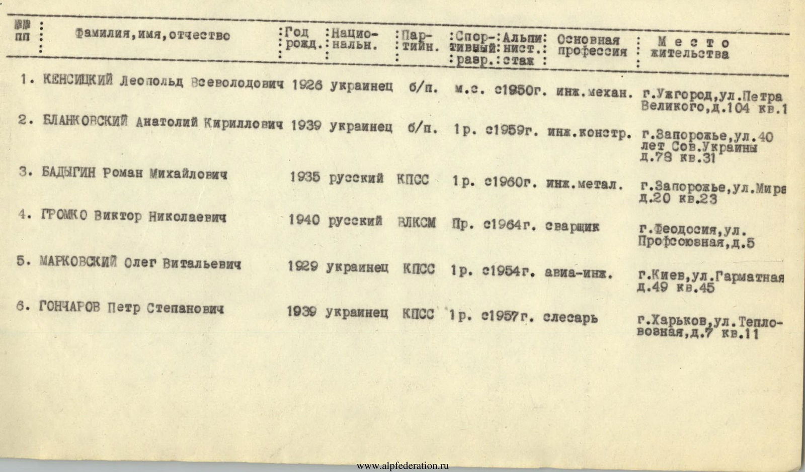
| № п/п | Surname, name, patronymic | Year of birth | Nationality | Party affiliation | Sports rank | Climbing experience | Primary profession | Place of residence |
|---|---|---|---|---|---|---|---|---|
| 1. | Kensitsky Leopold Vsevolodovich | 1926 | Ukrainian | non-party | Master of Sports | since 1950 | mechanical engineer | Uzhhorod, Petra Velikogo St., 104, apt. 1 |
| 2. | Blankovsky Anatoly Kirillovich | 1939 | Ukrainian | non-party | 1st sports rank | since 1959 | design engineer | Zaporozhye, 40 let Sov. Ukrainy St., 78, apt. 31 |
| 3. | Badygin Roman Mikhailovich | 1935 | Russian | CPSU member | 1st sports rank | since 1960 | metallurgical engineer | Zaporozhye, Mira St., 20, apt. 23 |
| 4. | Gromko Viktor Nikolaevich | 1940 | Russian | Komsomol member | 1st sports rank | since 1964 | welder | Feodosiya, Profsoyuznaya St., 5 |
| 5. | Markovsky Oleg Vitalyevich | 1929 | Ukrainian | CPSU member | 1st sports rank | since 1954 | aerospace engineer | Kiev, Garmatnaya St., 49, apt. 45 |
| 6. | Goncharov Petr Stepanovich | 1939 | Ukrainian | CPSU member | 1st sports rank | since 1957 | fitter | Kharkov, Teplovoznaya St., 7, apt. 11 |
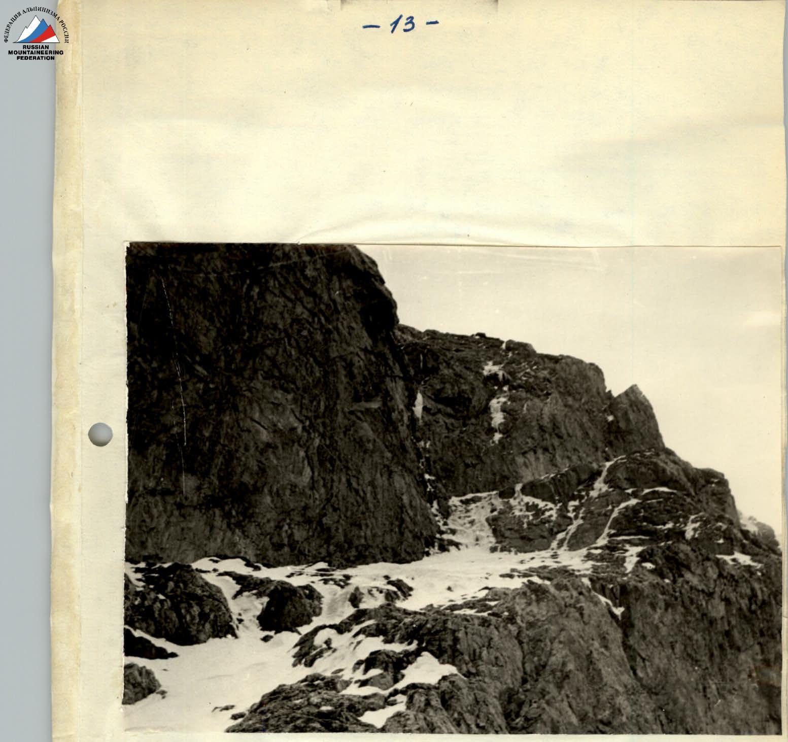
Icy inclined plate and sheer walls leading to the pre-summit ridge (sections R7–R10)

Pre-summit ridge (sections R12–R17)
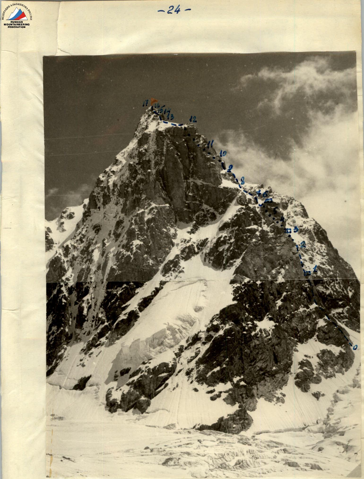
Sketch of the ascent route up the western wall of Peak Shchurovsky.
- — team route
- — overnight stays
Table of main characteristics of the ascent route
| Date | Section | Average steepness of the section | Height gain of the section | Terrain type | Technical difficulty | Belay method | Weather conditions | Departure time | Stop time | Travel hours | Rock pitons | Ice pitons | Boulder pitons | Overnight conditions | Ration weight | Notes |
|---|---|---|---|---|---|---|---|---|---|---|---|---|---|---|---|---|
| First day of the route | ||||||||||||||||
| July 30 | R0–R1 | 60° | 160 m | Rocky | Difficult snow-covered rocks | Piton belay | Good | 7:40 | 12:40 | 5:00 | 14 | On a snowy ledge in a tent | 0.8 kg | Further route processing 3–4 hours | ||
| Total for the day | 160 m | 5:00 | 14 | |||||||||||||
| Second day of the route | ||||||||||||||||
| July 31 | R1–R2 | 90° | 62 m | Rocky | Sheer wall, 15 m overhanging section | Piton belay | Good | 8:00 | 18:00 | 10:00 | 7 | 1 | 48 | |||
| R2–R3 | 70–80° | 40 m | Rocky | Difficult rocks | Piton belay | Good | 18:00 | 20:00 | 2:00 | 9 | 2 | On a rocky ledge without a tent | 0.6 kg | |||
| Total for the day | 102 m | 12:00 | 16 | 1 | 50 | |||||||||||
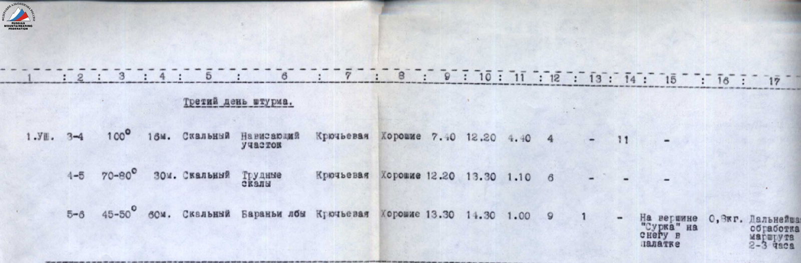
| Third day of the assault | ||||||||||||||||
| August 1 | R3–R4 | 100° | 16 m | Rocky | Overhanging section | Piton belay | Good | 7:40 | 12:20 | 4:40 | 4 | 11 | On the summit of "Surkov" on snow in a tent | 0.3 kg | Further route processing 2–3 hours | |
| R4–R5 | 70–80° | 30 m | Rocky | Difficult rocks | Piton belay | Good | 12:20 | 13:30 | 1:10 | 6 | ||||||
| R5–R6 | 45–50° | 60 m | Rocky | "Ram's foreheads" | Piton belay | Good | 13:30 | 14:30 | 1:00 | 9 | 1 | |||||
| Total for the day | 106 m | 6:50 | 19 | 1 | 11 | |||||||||||
| Fourth day of the assault | ||||||||||||||||
| August 2 | R6–R7 | 80–90° | 6 m | Rocky | Wall | Piton belay | Overcast | 6:00 | 6:20 | 0:20 | 2 | |||||
| R7–R8 | 25–30° | 100 m | Rocky | Plate, smoothed rocks | Piton belay | Overcast, occasional fog | 6:20 | 9:00 | 2:40 | 6 | ||||||
| R8–R9 | 70–80° | 40 m | Rocky | Wall | Piton belay | Overcast | 9:00 | 10:00 | 1:00 | 4 | ||||||
| R9–R10 | 70–80° | 25 m | Rocky | Wall | Piton belay | Overcast | 10:00 | 11:30 | 1:30 | 5 | ||||||
| R10–R11 | 45,–50° | 16 m | Rocky | Inside corner wall | Piton belay | Overcast | 11:30 | 12:00 | 0:30 | 1 | ||||||
| R11–R12 | 25–30° | 50 m | Snow-ice | Crossing a couloir | Piton belay | Overcast, occasional fog | 12:00 | 12:30 | 0:30 | 2 | 1 | Rest and snack 1 hour | ||||
| R12–R13 | 35–40° | Snowy. Snow-covered ridge | Through ice axe | Overcast | 13:30 | 14:00 | 0:30 | |||||||||
| R13–R14 | 50–60° | 65 m | Rocky | Snow-covered rocks of medium difficulty | Piton belay | Overcast | 14:00 | 15:00 | 1:00 | 5 | ||||||
| R14–R15 | 25–30° | 30 m | Rocky | Rocky ridge with snow cornices | Piton belay | Overcast, occasional snow | 15:00 | 15:30 | 0:30 | 4 | ||||||
| R15–R16 | 60–70° | 60 m | Rocky | Difficult snow-covered rocks | Piton belay | Overcast | 15:30 | 17:00 | 1:30 | 6 | ||||||
| R16–R17 | 45–50° | 30 m | Snow-ice | Nate ice at the bottom | Piton belay | Overcast | 17:00 | 17:40 | 0:40 | 2 | 0.6 kg | |||||
| Total for the day | 532 m | 11:40 | 38 | 1 | ||||||||||||
| Total on the route | 890 m | 35:30 | 87 | 3 | 61 |
The key section of the route is the western sheer wall of the gendarme "Surkov".
Description of the route passage
July 30 — first day of the assault. Having left the Kheldy refuge at 7:40, the team ascended via the Uzhbin icefall, crossed the couloir on the western wall of Peak Shchurovsky (in the couloir — a bergschrund, danger of rockfall from above) and reached the left side of the wall in its lower part.
At the beginning, the path goes up the rocks to the sheer wall, under which we make a traverse to the left along narrow cracks. Then we overcome the 3–4 m wall with an exit to the right, pass through loose snow-covered rocks to a small crack. From here, we exit left onto the wall along a weakly expressed inner corner. Then, along the rocks covered with snow, we approach the base of the plate.
The plate is quite steep (approximately 50°), covered with fresh snow. The exit to it is from the left, along the sheer wall, then we cross the plate along a crack to the right and upwards — to the beginning of a snow-filled chimney. Up the chimney, then along difficult rocks, we approach a 5–6 m wall with an inclined inner corner at the top. Then, along the snow-covered rocks, we exit under the base of a large sheer wall, next to a large crack clearly visible from below (section R0–R1).
Here is a narrow ledge filled with snow; after clearing it, we can find a place for a tent.
Movement along this section requires great attention and caution; the rocks are snow-covered, with many loose stones; belay is piton-based. All team members wore protective helmets — ice, snow, and sometimes stones fall from above.
Passage of the sheer section (section R1–R2)
By 13:00, the entire team gathers on the ledge. The leading trio (Kensitsky, Blankovsky, Gromko) begins processing the sheer section of the wall. The rest clear snow and prepare a place for the tent. By evening, about 20 m of the wall is processed.
Start of the route:
- To the right of the overnight stay
- Along the right edge of a large cracked plate
Here is the first control point.
July 31 — second day of the assault.
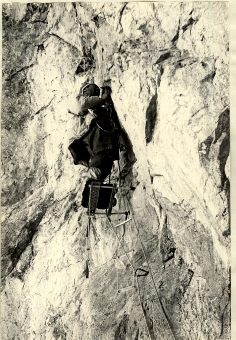
We rise at 6:30; the sun arrives here late — around 11:00. After breakfast, the leading trio moves on to process the route, while the others dismantle the bivouac and pack their backpacks. Then they begin to ascend the wall using platforms and ladders, using a fixed rope as a handrail.
At a height of 20–23 m from the start of the route, there is a narrow ledge — a crack (20–30 cm wide). Here, team members gather and organize the ascent of backpacks on a rope. For this, we use a special roller with a stop.
The leading group processes the last meters of the sheer wall. Further, there are steep smoothed rocks.
The first ascender reaches a narrow inclined ledge, secures the rope. The other team members begin to ascend using pitons, platforms, and ladders. Belay is provided by a handrail rope fixed at the top.
Upon reaching the top, we immediately organize the ascent of backpacks — the distance from the crack ledge to the top is about 40 m (section R1–R2).
The duo — Kensitsky and Blankovsky, having moved to the right along the ledges, are forced to sharply turn left and then ascend steep smoothed rocks, veering slightly to the right (section R2–R3).
Careful belaying is required — it's steep, with small and smoothed handholds. The other team members move along the fixed ropes. It's so steep that it's impossible to climb with a full backpack; we have to:
- lighten the backpacks several times
- make extra trips
After 40–50 m of such climbing, we reach a sufficiently wide ledge under the second sheer section of the wall.
Having cleared the ledge of piled-up stones and boulders, we settle in for the night already in the dark. We can't set up a tent — the ledge is too narrow, but we still manage to lie down, tied to a stretched handrail rope. We spend the night calmly.
August 1 — third day of the assault. We rise at 7:00 and prepare breakfast.
At 7:40, the leading trio (Kensitsky, Blankovsky, Goncharov) begins to ascend; the others dismantle the bivouac. We leave a second control point in a can on the wall.
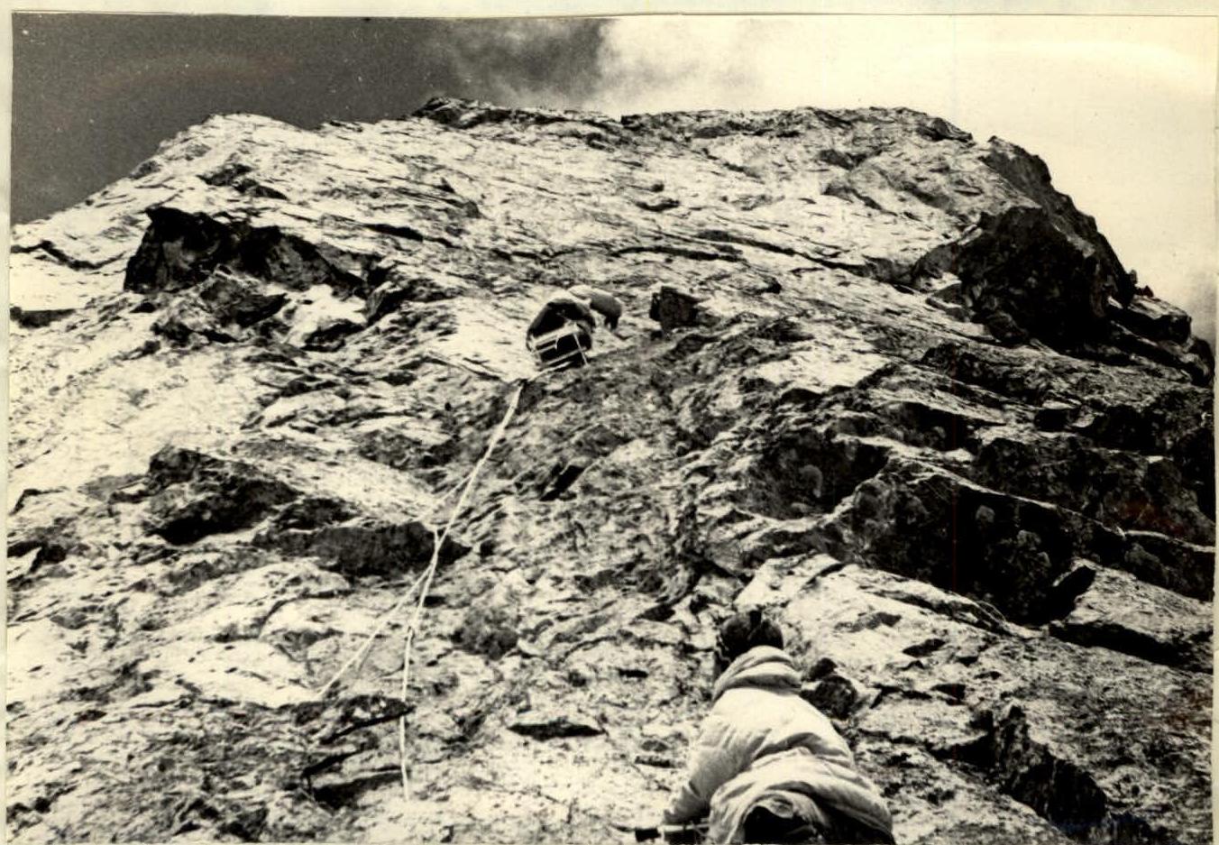
L. Kensitsky processes the overhanging section of the wall (section R3–R4).
The path upwards is complex — the wall overhangs for a distance of 16–18 m in height (section R3–R4). Working even from a platform is very uncomfortable. We take a long time to pass this section.
In the upper part of this section, the rocks become less steep, and ledges and steps appear. The duo — Kensitsky and Blankovsky — moves to the right along a narrow ledge, then ascends, overcoming a 2–3 m sheer wall (having driven two boulder pitons). Further, having moved left along difficult rocks, they reach an inclined ledge located almost above us at a height of 35–40 m.
Upwards, there is an 8–10 m inner corner (section R4–R5).
Using the ropes fixed by the first duo, we ascend to the ledge and organize the ascent of backpacks.
Having overcome the inner corner, we reach the destroyed "ram's foreheads" (section R5–R6). We ascend, veering slightly to the right, and reach a pass separating the head of "Surkov" from the massif of the peak.
On "Surkov" — the third control point. Time — 14:30. We decide to stay overnight on "Surkov".
After a short rest and lunch, we begin to prepare a platform for the tent:
- clear snow,
- cut ice.
Kensitsky, in a team with Blankovsky, proceeds to process the route using the remaining daylight. They traverse a plate, having fixed a rope:
- at the exit to the plate — a 5–6 m wall,
- on a section of wet rocks to facilitate passage in the morning when they are icy.
We spend the night calmly; sometimes, ice falls from the ridge onto the plate, even jumping over the pass.
August 2 — fourth day of the assault. We rise at 5:00, quickly dismantle the bivouac, and prepare breakfast. At 6:00, we depart — we need to pass the plate early. The exit to the plate is a 6–9 m wall (section R6–R7). We ascend to the left and upwards, using a ladder. Further, along an oblique ledge, we reach the plate (section R7–R8). We move in teams:
- Kensitsky — Blankovsky
- Gromko — Markovsky
- Badygin — Goncharov
We move with careful belaying. On icy rocks, the rope fixed in the evening helps; we pass along it with a Prusik knot.
Having approached the base of a 40 m wall (section R8–R9), we circumvent it to the right and begin to ascend the wall along a strongly destroyed inner corner. Belay is piton-based; old pitons are encountered. Soon, we reach the top of the wall — a slightly sloping shoulder leading to the base of the second sheer wall, 25 m high (section R9–R10).
The start of the ascent is a narrow inner corner, then a transition along a 3–4 m sheer wall (using two ladders).
Further, along unclear inner corners — cracks, we ascend to the top of the wall. The last transition of 3–4 m is made on hands, with no footholds. From the top of the wall, we traverse to the left and then, along a destroyed inner corner, exit under the ridge of the peak (section R10–R11). Here, it's relatively flat, and there's a place for an overnight stay — the fourth control point.
We cross the ice-snow couloir (section R11–R12). There's a significant avalanche danger here, and rockfall is possible from the ridge, which steeply drops off in this direction.
One by one, with belay, we cross the couloir and exit onto the ridge. Here, we take a break to rest and have lunch.
The further path goes along the ridge (section R12–R13). The ridge is covered with fresh snow; underneath, there's ice, but the snow holds well. We quickly move forward and approach a strongly destroyed wall, 60–70 m high (section R13–R14). The rocks are covered with fresh snow; handholds and footholds have to be found by touch. We pass this section with careful piton belaying. Then, there's a steep section of the ridge — a narrow rocky crest with snow cornices to the northeast (section R14–R15). Along it, we exit to the second rocky wall (section R15–R16). Its height is approximately 60 m; the rocks are strongly destroyed, covered with snow, and местами icy. When passing, we use handrails and carefully belay.
Along a steep snow-ice slope (section R16–R17), we ascend to the summit, having cut a passage through a small cornice. Time — 19:00. The weather is overcast all day; towards evening, it worsens — fog, occasional snow, and graupel. We quickly update the record in the cairn and begin to descend.
On the plateau, we meet observers from the Ukrsoyuzsport and ZakVO teams; there are questions, congratulations. But we want to descend to the Kheldy refuge today, so we soon bid farewell and leave.
The path along the icefall is familiar to us; the snow cover is in good condition — we pass it quite quickly. Downstairs, there are again joyful meetings with observers. We spend the night at the Kheldy refuge and depart for the camp on the morning of August 3, 1967.
VI. Conclusion
Assessment of the overall complexity of the ascent route and its individual sections.
The route taken by the team of the Central Council of the DSO "Avangard" along the western wall of Peak Shchurovsky is very interesting in sporting terms, beautiful, and logical.
The significant technical difficulty of individual sections of the route and its sufficient length allow it to be classified as a difficult route of category 5B. Some sections of the route, which are completely sheer or even overhanging, are elements of routes of category 6 difficulty (sections R2–R3, R3–R4, R4–R5).
Sections R6–R7, R8–R9, R9–R10 are also complex, with steepness of 80–35°.
The route can be recommended for passage as training before ascents on walls where it is necessary to overcome sheer sections of great length.
On behalf of the group
Participants: