Ascent Passport
I. Category of technical ascents
-
Central Caucasus, Main Caucasian Range
-
Peak Shchurovsky, 4259 m via the right edge of the North face
-
Assumed category 5B, first ascent
-
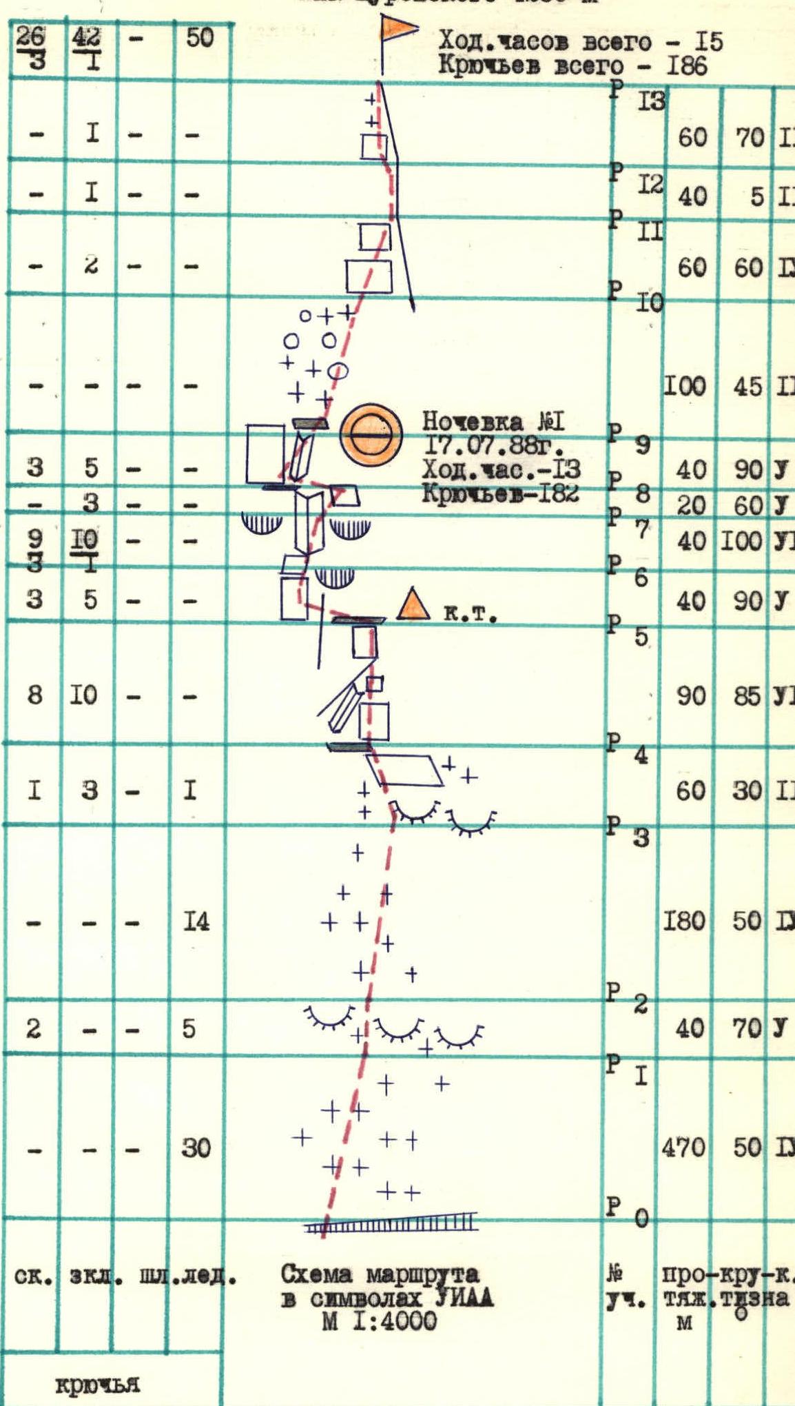
Height difference: route — 979 m, bastion — 219 m Length: route — 1240 m, bastion — 230 m, sections of 5–6 category — 270 m Average steepness: route — 57°, bastion — 87°
-
Pitons driven: total — 186 pcs., of which
| rock | chocks | bolt | ice screws |
|---|---|---|---|
| 26/3 | 42/1 | 0/0 | 50/0 |
- Time to the summit — 15 hours and 2 days
- Overnights: 1 — lying in a tent
- Leader: Ershov A.A. — Candidate Master of Sports
Team members: Galeev A.R. — Candidate Master of Sports, Galinov M.M. — Candidate Master of Sports, Isaev S.V. — Candidate Master of Sports, Kolomyttsev V.G. — Master of Sports, Shalaev A.N. — Candidate Master of Sports. 10. Coach: Kolomyttsev V.G. — Master of Sports
II. Departure to the route: July 17, 1988
Summit: July 18, 1988
Return: July 18, 1988

Photo 1. General photo of Peak Shchurovsky. Taken on July 16, 1988 at 14:00 from the turn of Shkheldinsky glacier (point #1). Lens "Jupiter-374".
- — Abalakov route
- — Kensitsky route
- — Khergiani route
- — Abalakov route
- — Team route
Tactical Actions of the Team
July 16, 1988. From the USAB "Dzhantugan" the team went to the German campsite, conducted observation and photography of the route, clarified the ascent route and tactics.
July 17, 1988. At 5:00 the team departed from the German campsite and at 5:30 the first rope team started working on the route. The ice-snow part of the route (sections R0–R4) was ascended by autonomous rope teams:
- Shalaev – Ershov,
- Kolomyttsev – Isaev,
- Galinov – Galeev.
The rope teams moved mostly simultaneously with protection via ice screws. The greatest difficulty on this part of the route was the "throat" (R1–R2, photo 5) with rams' foreheads covered with a crust of ice. Belays were used here.
By 10:00 the team approached the rocky part of the route — the bastion (sections R4–R9). The first rope team here was Galeev – Galinov. They moved on a double rope and set up belays. The rest of the participants followed the belays.
Ascent features:
- The rocks of the bastion are steep and complex, partially covered with ice.
- The first participants climbed without backpacks and in galoshes.
- The greatest difficulty when passing the bastion was a large overhanging inner corner (R6–R7, photo II), the walls of which were covered with ice.
- Here, the first climber had to work very carefully and attentively, using artificial points of support.
By 18:00 the team reached the top of the bastion. Here they set up platforms for tents and spent the night. At the end of the day, they had to climb in fog and snowfall, but when a strong bad weather with thunderstorm hit, they were already in tents.
July 18, 1988. At 9:00 the team left the bivouac and in 2 hours ascended to the summit via the несложным Western ridge. After traditional photography:
- descended through the Ushbinsky plateau,
- crossed the icefall,
- reached the German campsite,
- returned to USAB "Dzhantugan" by evening.
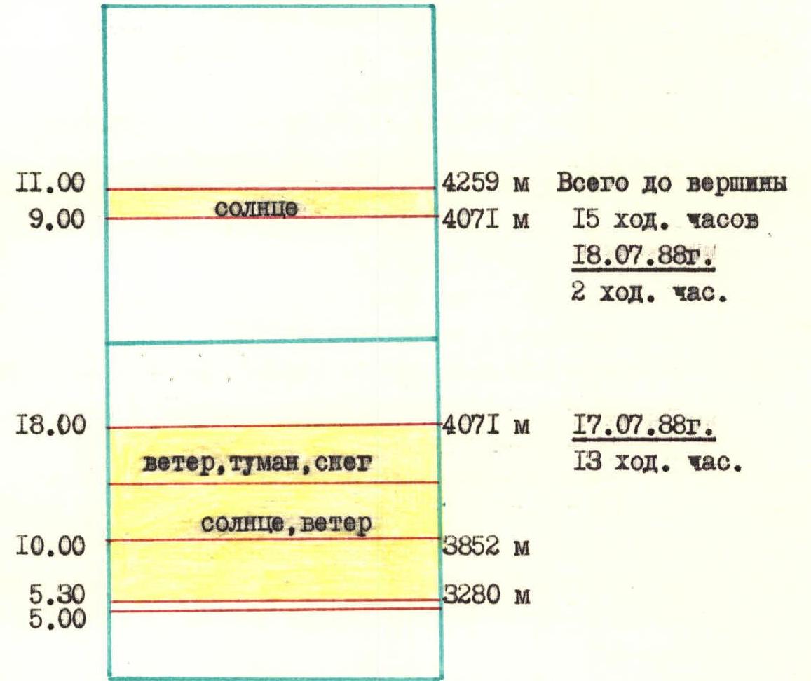
Ascent Schedule
July 18, 1988
- 11:00: 4259 m (summit). Total to the summit: 15 hours. Duration: 2 hours.
- 9:00: 4071 m (sun).
July 17, 1988
- 18:00: 4071 m (wind, fog, snow). Duration: 13 hours.
- 10:00: 3852 m (sun, wind).
- 5:30: 3280 m.
- 5:00: 3280 m.
Route Description by Sections
- R0–R1 — Overcoming the bergschrund along the avalanche cone. Movement along a steep ice-snow slope under the rocky ridge.
- R1–R2 "Throat" — Rams' foreheads with ice. Belays via rock and ice pitons. Ropes.
- R2–R3 — Steep ice-snow slope. At the end — exit to the right onto rams' foreheads.
- R3–R4 — Careful movement along rams' foreheads and slabs with snow. Exit to inclined shelves under the bastion.
- R4–R5 — Very complex climbing up the 90-degree wall to the right of the edge. Exit to an inclined shelf with loose rocks. On the shelf to the right — a control cairn.
- R5–R6 — Along the shelf to the left onto the wall and then onto slabs under the overhanging inner corner.
- R6–R7 — Key section of the route. Very complex climbing up the overhanging inner corner. At the end — exit to the right onto steep slabs. Artificial points of support. Ice.
- R7–R8 — Along steep rocks traverse to the left onto a shelf under the wall.
- R8–R9 — Complex climbing up the wall, then the inner corner with ice and exit to the top of the bastion. Overnight stay.
- R9–R10 — Along snow and snow-covered rocks — under the ascent of the Western ridge.
- R10–R11 — Along steep snow-covered rocks — ascent to the ridge. Loose rocks.
- R11–R12 — Movement along the ridge — under the pre-summit ascent.
- R12–R13 — Along steep snow-covered rocks and snow slope — ascent to the summit. Note: on R4–R9 the first climber works on a double rope, the group moves along the belays.
Photo 4. Technical photo of the route. Taken on July 16, 1988 at 15:30 from the German campsite. Lens "Jupiter-374".
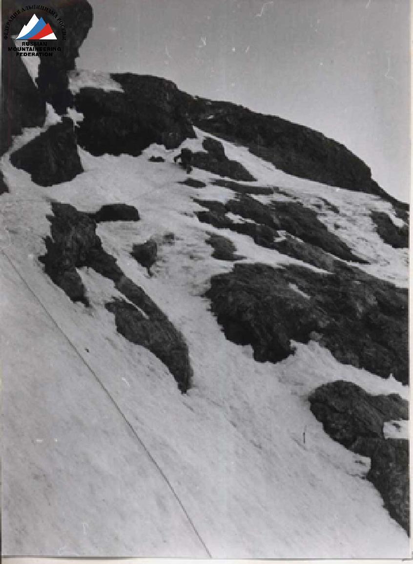
Photo 5. View from below at section R0–R2
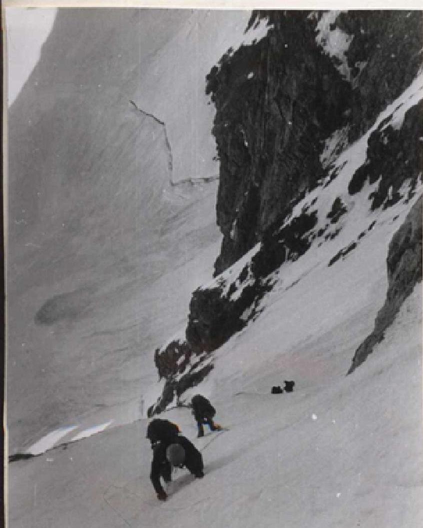

Photo 6. View down from section R2