- Traverse of Shkhelda massif from east to west (V. Nesterov's route, category 5B).
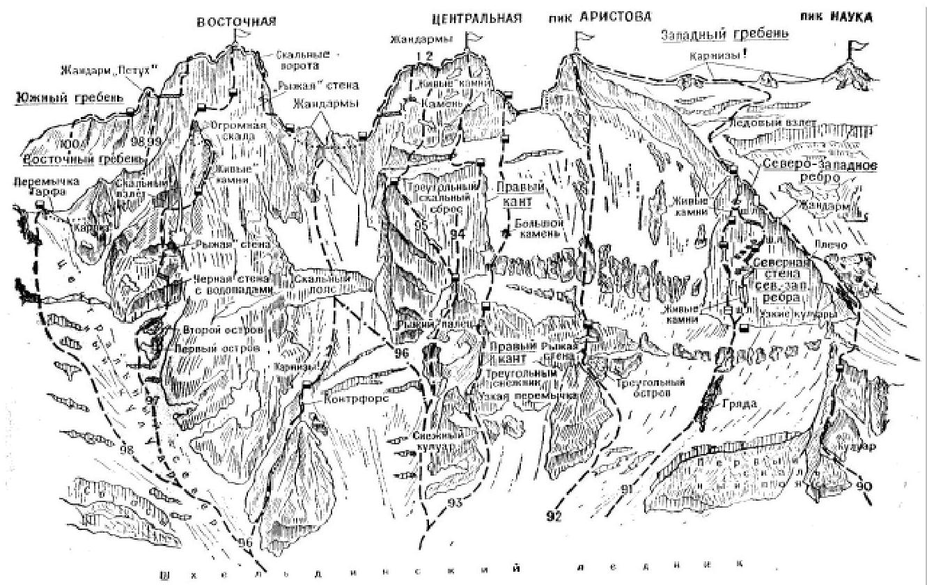
The path from Shkhelda alpine camp (group of 4-8 people) to the summit of Shkhelda Eastern is described in route 100. From the summit, descend 40 m down simple rocks of the Western ridge to a platform. From the platform, bypassing the ridge, descend into huge rock gates between two gendarmes. From the gates, make a 35-meter sporty descent down an icy couloir, followed by two 40-meter rappels and a descent down snowy, steep rocks of medium difficulty, initially down the slope and then along the ridge - a 70-80 m descent to a platform under the 2nd (from the east - 1st) gendarme of the ridge. The platform is a bivouac site.
From the platform, bypass the 2nd and 1st gendarmes located on the ridge between the Eastern and Central summits, along a rocky and then snowy shelf, and then along rocks of medium difficulty on the left side of the ridge to reach a platform under the ridge connecting the Eastern ridge of Shkhelda Central's rock tower. From the platform, ascend rocks of medium difficulty to the ridge under the Eastern wall, and from it, 40 m up rocks of medium difficulty, and then up difficult rocks of the wall to reach a ledge.
Along the ledge, and then across a 6-7-meter smooth, steep slab - traverse right to a chimney. Up the steep, smooth, difficult chimney, ascend 5 m to a second ledge. Along the ledge, bypass a huge rock to the right. Behind the rock - straight up a 20-meter wall ("live" cams!), with small talus ledges - to the ridge of the eastern shoulder of the summit. Up the steep, destroyed ridge of the shoulder, ascend to a small gendarme. Descend from it under the 2nd gendarme, which is bypassed on a ledge from the left, and behind it - exit to a platform above a small gap in the ridge.
From the platform, descend 20 m down rocks of medium difficulty of a 20-meter wall into the gap under the summit ascent. From the gap, ascend 40 m up steep, heavily destroyed rocks of medium difficulty and difficult rocks of the ascent, and then along simple rocks, exit to the Central summit. From the gap, the ascent can be bypassed on the left and ascend to the summit along the southern counterfort. From the bivouac, 4.5-5 hours.
From the summit, descend down a simple 30-meter rocky Western ridge, and then with five 40-meter rappels, descend to the ridge under the peak Aristova. The ridge is a bivouac site. Along the ridge, exit under the rocky ascent of the Eastern ridge of peak Aristova. Up the rocky ascent, ascend a 5-6-meter difficult wall. Then, 40-50 m up steep rocks of medium difficulty to a snowy ledge. Along the ledge, with 35-40-meter traverses to the left, through a small gap, exit to a rocky couloir and up it, ascend to a horizontal shoulder of the Eastern ridge. Along the horizontal, simple rocky ridge, exit under the rocky ascent of the summit tower.
From here, straight up, initially along rocks of medium difficulty of a 50-60-meter couloir, and then up 10-meter difficult rocks and a 6-meter crack - ascend to a ledge, from which up a 5-6-meter difficult wall - ascend to the eastern tower of the peak. From the tower, through a small saddle, along simple rocks - exit to peak Aristova. From the ridge, 5-7 hours.
From peak Aristova, descend along a simple rocky ridge, and then along a simple, long snowy ridge, overcoming a small gendarme along simple and medium difficulty rocks of the ridge. Behind it, along a simple snowy ridge, exit under peak Nauki. Up rocks of medium difficulty of a snowy ridge, ascend to the peak. From peak Aristova, 3-4 hours.
From peak Nauki, descend down a steep, simple, and medium difficulty rocky, heavily snowy ridge. A small gendarme of the ridge is bypassed on the left. Behind the gendarme, along a sharp, steep snowy ridge (cornices!), descend to a snowy ridge under the 6th (1st from the east) gendarme of the ridge Stroiteley.
From the ridge, bypass a slab on the right and ascend 4-5 m up a difficult wall, and then make a small traverse to the right and up an angle turning into a crack, ascend 25 m to a ledge. From the ledge, up a 25-meter edge, and then steep 10-15-meter slabs. Further along simple rocks, exit to the 6th gendarme. From the gendarme, down steep, medium difficulty, and in places difficult rocks of the ridge, descend to a platform under the 5th gendarme of the ridge Stroiteley.
From the ridge, 40 m straight up difficult rocks of the wall. Further along a sharp rocky ridge - exit to a platform under the rocky tower of the gendarme. From the platform, descend left down an internal angle. From the angle, traverse along rocks of medium difficulty on the left side of the gendarme to exit to a snowy ridge. The 5th gendarme can be bypassed with a 100-120-meter traverse along ledges and rocks of medium difficulty on the left side.
Further down a steep, sharp snowy ridge (cornices!) - descend to a snowy ridge under the rocky ascent of the 4th gendarme of the ridge Stroiteley. From the ridge - straight up difficult rocks of the wall with several ledges and along an oblique crack - ascend to the ridge of the gendarme. Up a steep, destroyed rocky ridge - ascend to the gendarme.
From the gendarme, down initially along simple, gentle rocks, and then along a steep snowy ridge into a snowy cirque under the 3rd gendarme of the ridge Stroiteley. From the cirque, up rocks of medium difficulty of a heavily destroyed 70-80-meter wall, ascend to its ridge, and further along a sharp, simple ridge, exit to the 3rd gendarme. From it, descend 20 m down a steep ridge and up simple and medium difficulty rocks of a sharp ridge, ascend to the 2nd gendarme of the ridge Stroiteley.
From the gendarme, along a sharp rocky ridge, descend to a ridge under a large black gendarme - the 1st (from the west) gendarme of the ridge Stroiteley. From the ridge under the 1st gendarme, make a small descent down a counterfort to the left, and then straight up rocks on the left side of the gendarme's wall to a narrow oblique ledge. From the ledge, up a slit-like chimney, ascend to the eastern ridge under the summit tower of the gendarme.
The summit of the gendarme is bypassed on the left along inclined, snowy slabs. Then, along simple, destroyed rocks and a snowy slope, exit to its western ridge. The summit of the gendarme can be bypassed along difficult rocks of the wall on the right. Down a sharp snowy (cornices!) western ridge with small sections of rocks - descend to a ridge under the eastern ridge of the summit Vtorya Zapadnaya Shkhelda.
From the ridge, up rocks of medium difficulty of a 12-15-meter wall and a 4-5-meter chimney, ascend to the Eastern ridge. Along a simple, snowy rocky ridge, exit under the rocky ascent of the ridge. The ascent is bypassed on the left along inclined slabs and up a couloir, ascend behind it to the ridge. Up destroyed, simple rocks of the ridge, overcoming small gendarmes head-on, ascend to the summit Vtorya Zapadnaya Shkhelda.
From Vtorya Zapadnaya Shkhelda, down destroyed, simple, and medium difficulty rocks of the Western ridge, descend to a ridge under the Eastern ridge of the summit Shkhelda Zapadnaya. From the ridge, up simple, destroyed rocks of the Eastern ridge, ascend to Shkhelda Zapadnaya, and down simple rocks of the Western ridge, descend to a snowy saddle between Shkhelda Zapadnaya and peak Profsoyuzov.
From the saddle, up a simple rocky, snowy ridge, ascend to peak Profsoyuzov and down the same path, descend to the saddle. From the saddle, descend north down a steep icy-snowy slope, and then along a crest, further down the glacier Akhsu - exit to "Aristova's overnight stay". From it, along a trail, return to the alpine camp "Shkhelda".
Special equipment for 4 people:
- main rope - 2 × 40 m
- rappel rope - 40 m
- expendable rope - 40 m
- rock pitons - 40
- ice pitons - 5-6
- carabiners - 12-14
- rock hammers - 2
- crampons - 4 pairs
- tent - 1
Possible bivouac sites are described in route 101 ("Baksan Valley", A. F. Naumov)