Passport
-
Class of winter ascents
-
Central Caucasus, Main Caucasian Range
-
Shkhelda Central via the center of the left rock bastion on the northern wall, first ascent
-
Difficulty category – proposed 6A
-
Height difference – 1295 m, route length – 1727 m
-
Length of sections with 5–6 difficulty category – 872 m. Length of sections with 6 difficulty category – 347 m. Average steepness of the wall part of the route – 65°
-
Pitons hammered: rock – 118, ice – 88, protection gear – 93, bolted – 11
-
Team's working hours – 60, days – 6
-
Overnights:
- 1 on a snow-covered rock balcony, lying down
- 2, 3, 4 on a snowy ridge, lying down
- 5 on a leveled and built-up snow buildup under the summit tower, semi-reclined
- 6 under the summit on a leveled snow cornice, lying down
-
Senior team coach: Pogorelov Alexander Grigorievich – International Master of Sports Team coach: Shemenev Alexander Grigorievich – International Master of Sports Leader: Polokhov Vitaly Fedorovich – Master of Sports Participants:
- Astakhov Mikhail Valentinovich – Master of Sports
- Nikitenko Viktor Borisovich – Master of Sports
- Kolisnyk Vasily Vladimirovich – Candidate for Master of Sports
- Koshelenko Yuri Vladimirovich – Master of Sports
-
Departure to the route: February 19, 1995 Summit: February 24, 1995 Return to camp: February 25, 1995
-
Organization: Rostov Regional Federation of Alpinism and Rock Climbing
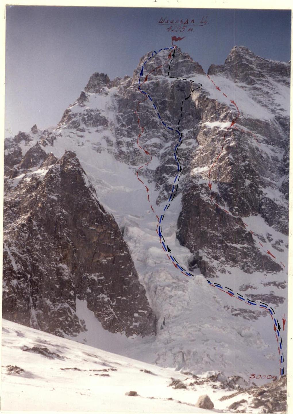
Photo 1. General photo of Shkhelda Central summit. February 19, 1995, 8:00. Camera "Smena-35". Distance to object 600 m. Height 3000 m. — Route taken by the team — Subortovich's route 1959 – 6A category — Khergiani's route 1959 – 5B category
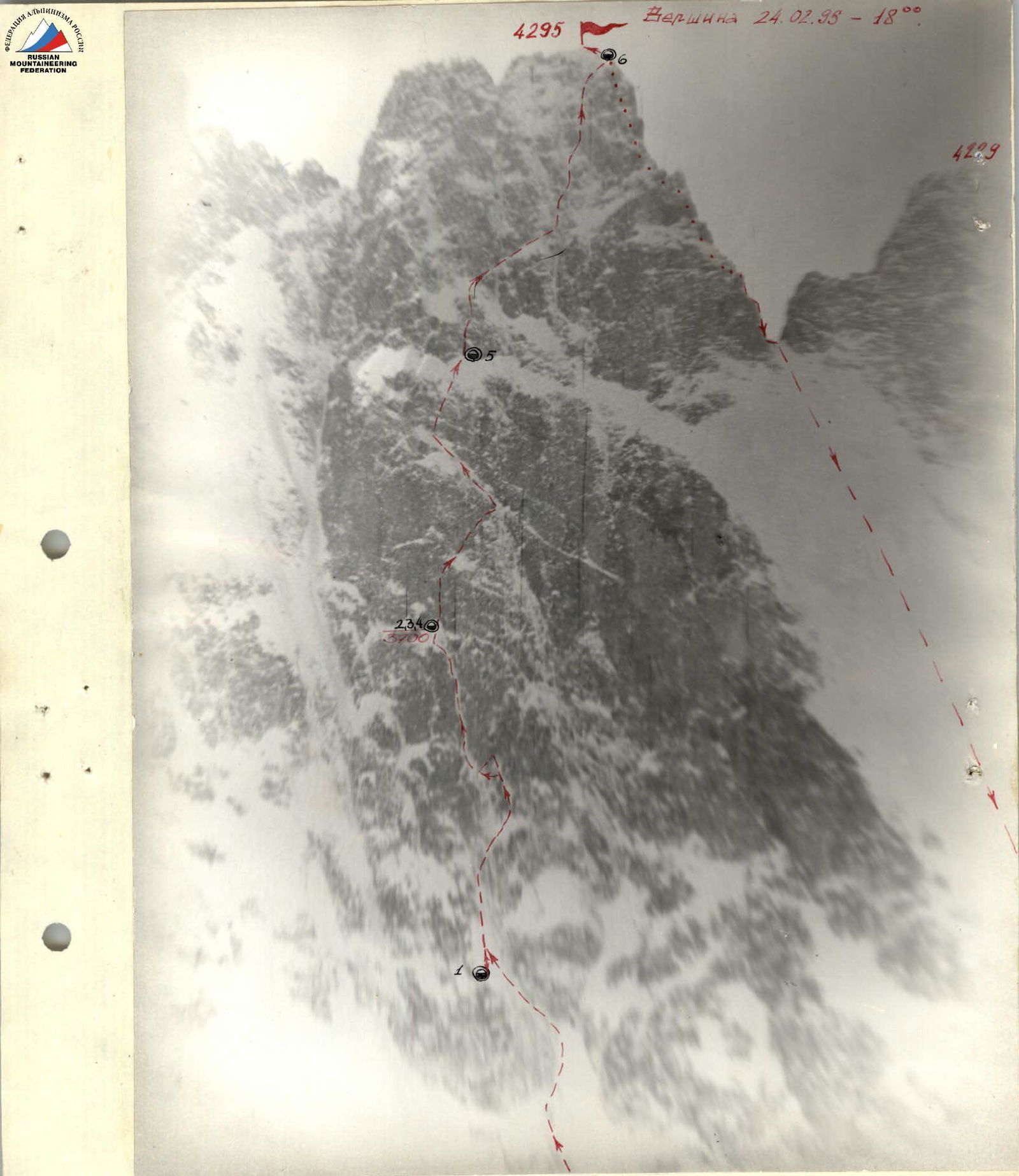
Photo 2. View of the wall from the left. February 16, 1995, 14:00. Camera "Zenit-E", lens "Yupiter-37A". Distance to object 1000 m. Height 4037 m.
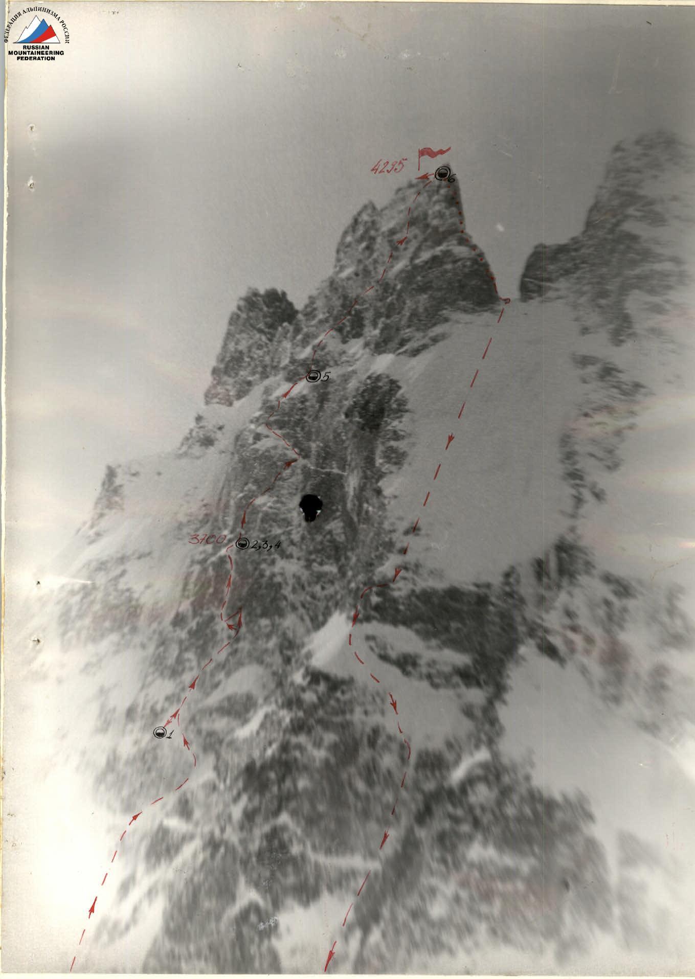
Photo 3. Profile of the wall from the right. February 15, 1995, 10:00. Camera "Zenit-E", lens "Yupiter-37A". Distance to object 2000 m. Height 3000 m.
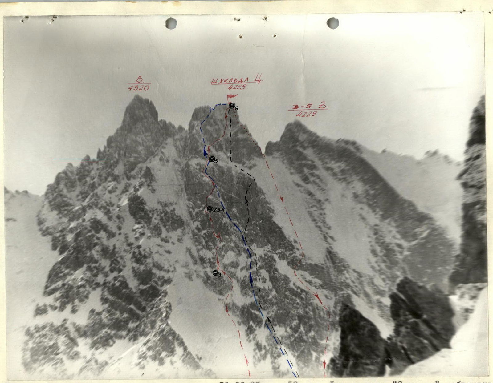
Photo 4. Photopanorama of the ascent area. February 16, 1995, 13:00. Camera "Zenit-E", lens "Helios". Distance to object 1000 m, height 3950 m.
Tactical Actions of the Team
The team worked on the route according to the tactical plan drawn up based on reconnaissance and assessment of the route's condition.
On February 19, on the first day of work, they managed to get ahead of the planned schedule. However, on section #18, it snowed non-stop for two days, and powder avalanches occurred.
On February 21 and 22, work on the route was carried out in bad weather. Given these circumstances, from section #19-20, they decided to move to a shelf used by Khergiani's route.
On February 23, the team managed to work on part of the route to the pre-summit tower after the bad weather.
On February 24, the team reached the summit.
The successful ascent was facilitated by the team's good physical, technical, and tactical preparedness.
To organize good overnight stays, they used kerchiefs that were packed with snow, allowing the team to recover well during the night.
Work on the route was carried out by two rope teams with changing leaders, allowing them to rhythmically pass sections on the route. The team's cohesion allowed them to combine the composition of the rope teams.
The work on the sections was distributed as follows:
- Koshelenko — R15–R18, R23–R26, R34–R36
- Nikitenko — R7–R14, R20–R22
- Polokhov — R19, R27–R33, R37–R39
- Kolisnyk — R4–R6
The first worked on a UIAA rope, with belay through an improved "bug" by Koshevnik. The belay station was organized from three block-placed elements. The movement of the other participants was carried out on double ropes.
The main problem was passing sections of iced, smooth rocks.
The selection of modern technical means allowed the team to safely pass the route in winter conditions.
During the ascent, they maintained constant radio contact with observers and rescue teams.
Total working hours – 60 hours
February 24. Working hours – 12 hours
- R39–R40: 20 m, 20°, 3
- R38–R39: 35 m, 80°, 5
- R37–R38: 60 m, 85°, 6
- R36–R37: 40 m, 75°, 5
- R35–R36: 40 m, 70°, 5
- R34–R35: 40 m, 75°, 6
- R33–R34: 40 m, 50°, 5
February 23. Working hours – 12 hours
- R32–R33: 15 m, 75°, 5
- R31–R32: 15 m, 90°, 6
- R30–R31: 12 m, 80°, 6
- R29–R30: 40 m, 40°, 4
- R28–R29: 15 m, 70°, 6
- R27–R28: 15 m, 90°, 6
- R26–R27: 10 m, 75°, 5
- R25–R26: 30 m, 50°, 4
- R24–R25: 40 m, 50°, 4
Route Description by Sections
R0–R1. Ascent along a snowy slope alongside the glacier. Deep snow.
R1–R2. Exit onto the glacier and up the middle part to the narrowest part of the bergschrund. Movement in rope teams, with crampons.
R2–R3. 10-meter ice section. Passed using ice axes. Belay via ice screws.
R3–R4. Movement in rope teams through the center of the glacier. The first crevasse is bypassed on the left, the second on the right; near the rocks, we ascend to a vaguely defined internal corner.
R4–R5. Small internal corner filled with ice. At the top, we ascend to the right along a rocky wall. Rocks are snow-covered. Belay via ice screws, at the top – protection gear and pitons. Ropes.
R5–R6. Ascent of 10 m along snow-covered rocks, then left along an iced shelf. Very difficult to choose a spot for belay organization. Used ice axes for passage.
R6–R7. Iced shelf, snow-covered at the top in places. Difficult to organize belay and anchor point for ropes.
R7–R8. Ice-snow shelf going right along the rocks.
R8–R9. Ascend a steep ice slope to the left. Used ice hammer "Shakal" and ice axes. Passage is extremely cautious.
R9–R10. Steep ice slope. At the top, find a small snowy shelf and organize an overnight stay.
R10–R11. Movement along serac ice. At the top of the 40-meter section, manage to reliably organize an anchor point.
R11–R12. Steep diverse rocks. Cracks are mostly filled with ice. Varied belay. Organize an anchor point under a small overhang on the left.
R12–R13. Steep, smooth rocks filled with ice. Last 10 m passed using ITO. From the anchor point, move 10 m pendulum-style to the left into an ice gully.
R13–R14. Ascent along an ice gully – 30 m, steepness 55°. Belay via ice screws.
R14–R15. Ice steepness increases. Ascent up the ice gully.
R15–R16. 15-meter section at the top of the gully is particularly dangerous. Steepness around 80°, ice thickness on rocks is thin. Takes a long time to choose belay points.
R16–R17. Ice gully begins to flatten and at the top abuts a snowy ridge.
R17–R18. Ascend the snowy ridge to a monolithic wall. Prepare a site and set up a tent.
R18–R19. Night and day of bad weather. Snowfall non-stop. Constant powder avalanches. Working in such weather is particularly challenging. 40-meter section passed entirely on ITO, along a small crack. At the top, the crack disappears, necessitating the use of bolts. 40 m covered in a day, considered a success. Overnight stay at the same spot.
R19–R20. Weather conditions unchanged. A pair moves out to process the route. An ice shelf allows partial simplification of the route, and they process a section to the right along the shelf.
R20–R21. Considering the weather, decide to alter the previously planned route and move towards Khergiani's route (this option was considered for bad weather). 20 m of an iced internal corner passed with ITO.
R21–R22. Traverse up to the right along smooth, iced rocks, 6th category difficulty. Unable to cover more today.
R22–R23. Another 20 m of traverse up to the right allows exit onto an ice shelf (Khergiani's route).
R23–R24. Steep ice. Passed using ice axes and an ice hammer "Shakal".
R24–R25. Ice-snow shelf.
R26–R27. 10-meter section of snow-covered rock wall.
R27–R28. 15 m – a large crack with a slight overhang. Rocks are snow-covered; initially clear snow, then pass the section on ITO.
R28–R29. Iced, smooth rocks; at the top – an ice section. This is the exit to a shelf above the summit tower.
R29–R30. Deep snow. Move towards an ice couloir. Organize an overnight stay to the right.
R30–R31. Ascent along an ice couloir – 12 m, steepness 80°. Piton belay.
R31–R32. Ice in the gully is very thin, so the next section is passed on the left along steep, snow-covered rocks. ITO. Piton belay.
R32–R33. Return to the gully and pass another 15 m. Descend for an overnight stay.
R33–R34. Pass another 20 m along the ice gully and at the top – 20 m through snow under the next rock bastion.
R34–R35. Traverse right through the central couloir onto a snowy shelf. Steep, iced rocks. Piton belay. In the couloir – ice screws.
R35–R36. Rocks filled with ice. Ice axes – "Shakal". Difficult to find a spot for belay.
R36–R37. Rocks filled with ice. Ice axes – "Shakal". Again, problems with belay.
R37–R38. 60-meter rock section along thin, "live" slabs. Belay on such rocks is not reassuring. Extreme reliability in work.
R38–R39. By clearing snow buildup from rocks and at the top, cutting through a cornice, exit onto the ridge.
R39–R40. 20 m – a snowy rock ridge. This is the summit. Tired and joyful. Overnight stay on the ridge under a starry sky.
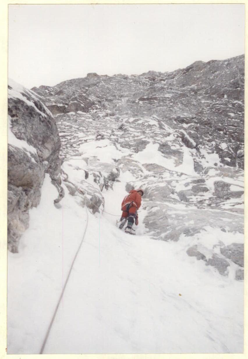
Photo 6. Section. February 20, 1995, 9:00. Camera "Smena-35".