XIV Open CIS Championship (EAAC) in Alpinism
in the technical class of 2005
Report
on the ascent to the summit of Shkhelda Central via the "Mirror" on the S wall, route by G. Polevoy, 1971, second ascent, 6A category of difficulty
Team from Nizhny Tagil.
Team leader: Ravilov R.A. Team coach: Ravilov R.A.
Contact addresses and phone numbers
Municipal Educational Institution for Additional Education of Children, Youth Sports School "Start"
622034, Sverdlovsk region, Nizhny Tagil, Mira Avenue, 6 Phone/fax: (3435) 41-73-98
Coach, team leader: Ravilov Raif Abdrakhmanovich
622031, Sverdlovsk region, Nizhny Tagil, Uzkaya St., 1
Ascent passport
- Caucasus, Shkhelda gorge, 2.4.261(a)
- Name of the summit: Shkhelda Central, 4295 m, via the "Mirror" on the S wall
- Proposed: 6A category of difficulty, second ascent
- Route type: combined
- Height difference of the route: 1524 m
Route length: 1795 m
Length of sections: * V category of difficulty — 375 m * VI category of difficulty — 235 m
Average steepness: * main part of the route — 84° * entire route — 68°
- Pitons left on the route: total – 71*; including stationary pitons – 30*
Pitons used on the route: * stationary pitons – 30* * including artificial climbing aids (ITC) – 22* * removable pitons – 0 * including ITC – 0.
Total artificial climbing aids (ITC) used — 31
- Team's climbing hours: 47 h 5 min
- Leader: Ravilov Raif Abdrakhmanovich, Candidate for Master of Sports
Participants: Gorshkov Evgeny Mikhailovich, 1st sports category; Kononenko Alexey Alexandrovich, 1st sports category; Litvinov Kirill Pavlovich, 1st sports category; Khoroshilov Alexey Nikolaevich, 1st sports category
-
Coach: Ravilov Raif Abdrakhmanovich, Candidate for Master of Sports
-
Departure for the route: 8:00, August 15, 2005
Reached the summit: 19:00, August 19, 2005 Returned to the base camp: 14:00, August 21, 2005
* – previously driven pitons.
General photo of the summit
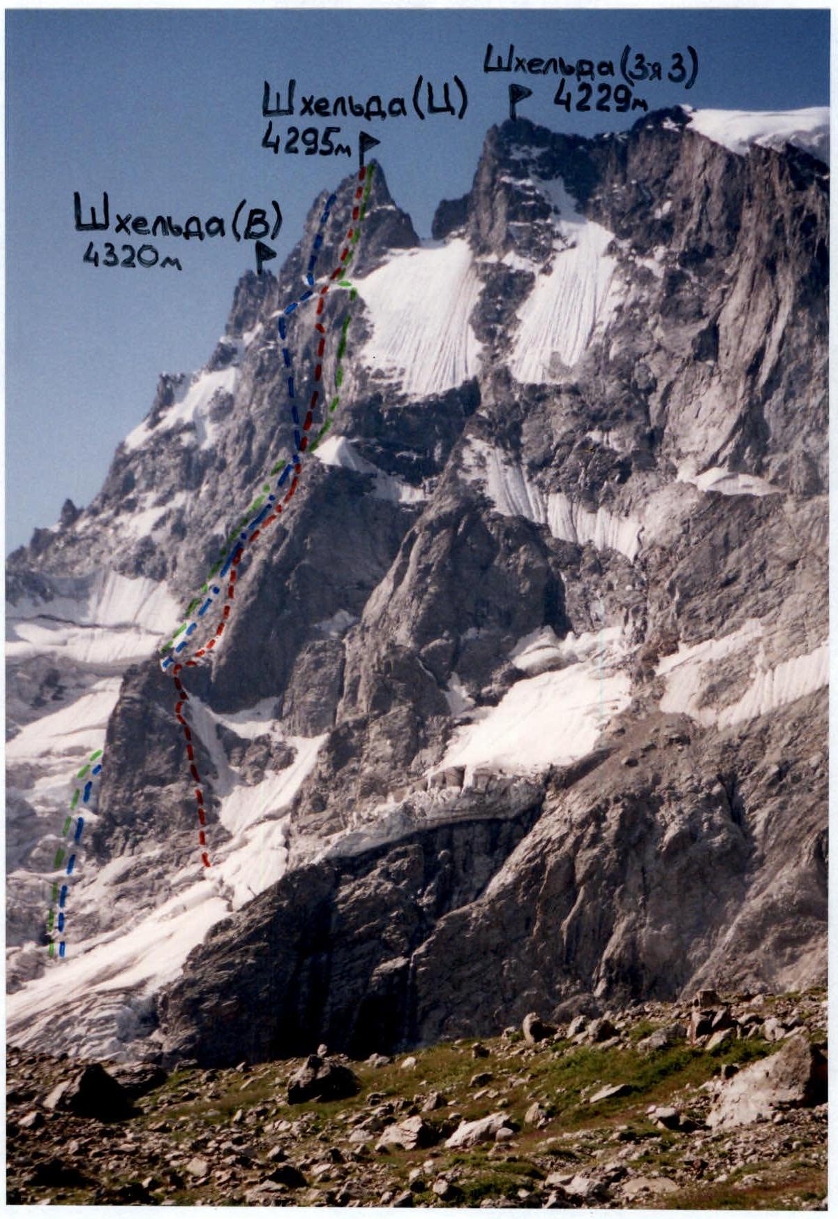 Route taken by the team
Route on the S wall, B. Subartovich, 1959 (2.4.261)
Route on the left edge of the S wall, M. Khergiani, 1959 (2.4.261)
Photo taken from the moraine of the Shkheldinsky glacier on August 14, 2005
Route taken by the team
Route on the S wall, B. Subartovich, 1959 (2.4.261)
Route on the left edge of the S wall, M. Khergiani, 1959 (2.4.261)
Photo taken from the moraine of the Shkheldinsky glacier on August 14, 2005
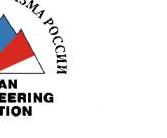
Route profile
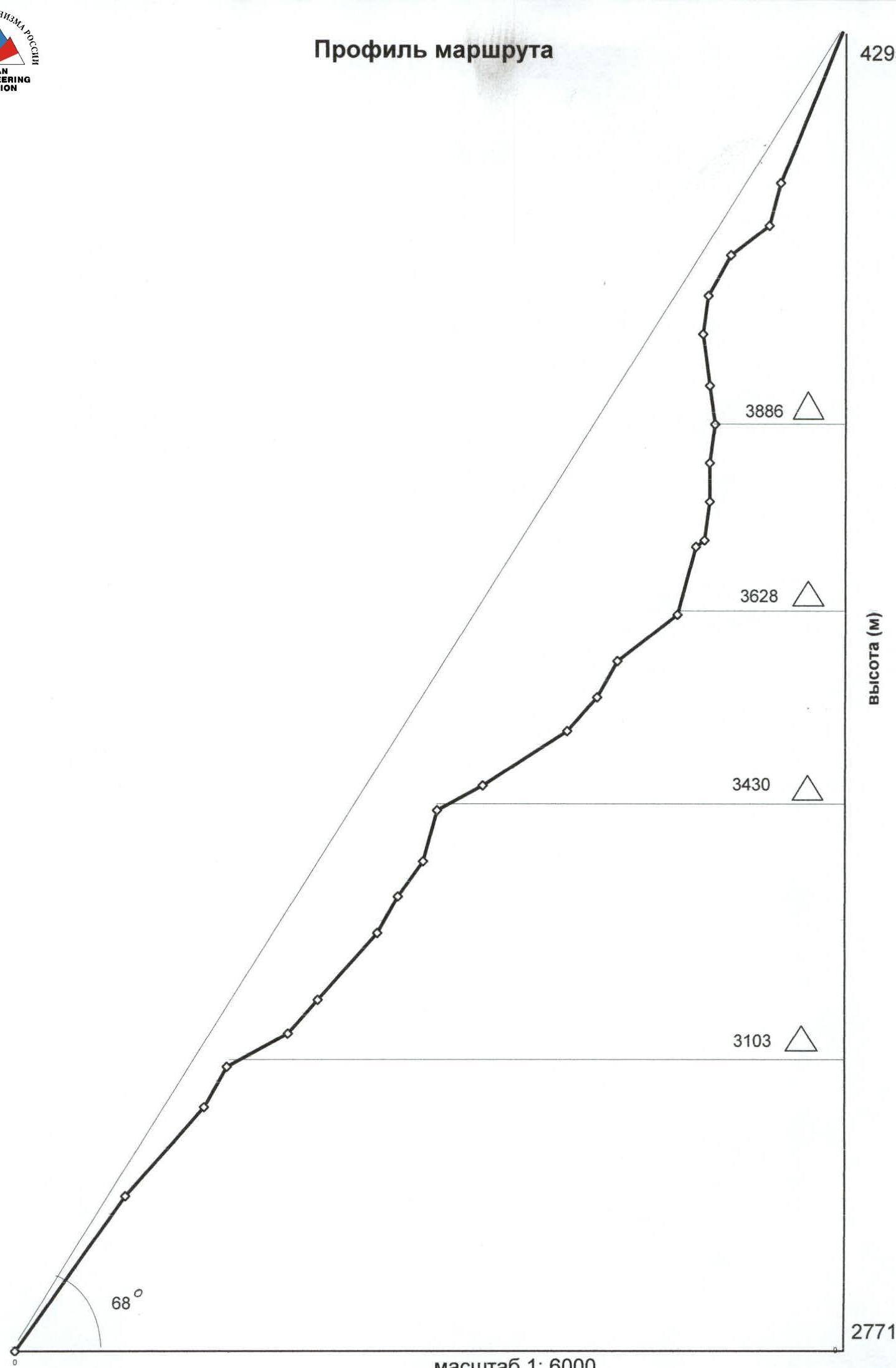
Ascent graph
| Section № | Rock | Chocks | Pitons | Ice | Section characteristics | Difficulty in UIAA | Length in meters | Steepness in degrees |
|---|---|---|---|---|---|---|---|---|
| R0 | 12* | 8 | 7 | III+ | 200 | 65° | ||
| R1 | 3* | 7 | 5 | 2 | III+ | 120 | 60° | |
| R2 | 1* | 1 | 2 | Saddle Plant | IV | 50 | 70° | |
| R3 | 2 | ledge | II | 60 | 40° | |||
| R4 | 1* | 1 | 1 | III | 45 | 60° | ||
| R5 | 1 | 3 | III+ | 90 | 60° | |||
| R6 | 2* | 1 | 8 | V | 45 | 75° | ||
| R7 | 4 | 3 | IV | 45 | 65° | |||
| R8 | 4* | 10 | V | 60 | 80° | |||
| R9 | 3* | 1 | 2 | 1* | III | 45 | 40° | |
| R10 | 2* | 2 | 5 | III | 90 | 45° | ||
| R11 | 2 | 5 | IV | 45 | 60° | |||
| R12 | 1 | 8 | IV+ | 45 | 70° | |||
| R13 | 2* | 2 | IV | 70 | 50° | |||
| R14 | 1* | 2 | III | 45 | 30° | |||
| R15 | 2 | 20 | 2 | V+ | 80 | 80° | ||
| R16 | 2 | 1 | IV | 10 | 50° | |||
| R17 | 4 | 10 | V+ | 45 | 85° | |||
| R18 | 2 | 13 | 3 | Chip. Difficult traverse to the chip 8 m. | VI A₁ | 45 | 90° | |
| R19 | 1 | 3 | System of chips | V+ | 45 | 85° | ||
| R20 | 5* | 12 | 1 | 4* | VI A₁ | 45 | 95° | |
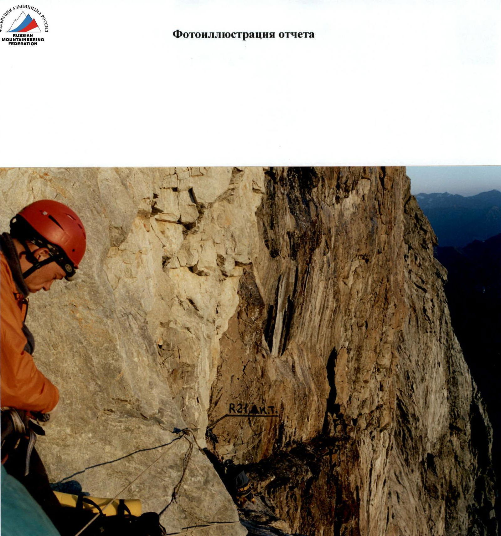
| R21 | 3 | 7 | 2* | Traverse to the black "mirror". | VI | 40 | 90° | |
| R22 | 1 | 4 | 17 | 16 | Control point (C.T.) | VI A₂ₑ | 60 | 95° |
| R23 | 1* | 4 | 3 | 2 | VI A₂ₑ | 45 | 85° | |
| R24 | 1* | 2 | 8 | V | 50 | 70° | ||
| R25 | 2 | 5 | IV | 45 | 50° | |||
| R26 | 2 | 8 | 1* | V | 50 | 80° | ||
| R27 | 3* | 6 | 18 | IV | 180 | 75° |
* – previously driven pitons. 4 / 1 – total pitons / of which ITC.
R21–R22 Overnight stay on a sloping rock shelf. Location of the control tour.
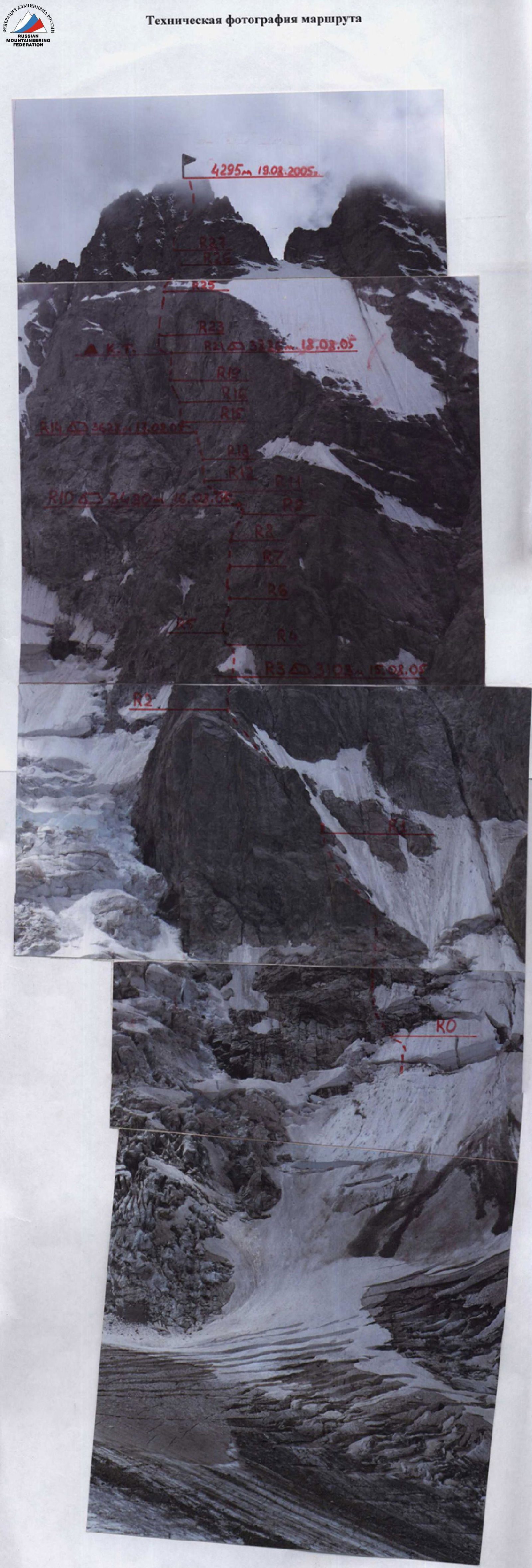 Technical photograph of the route. Height 4295 m, August 19, 2005. R3: 3103 m, August 15, 2005
Note from the summit
The group of the Alpinist Club "Odessa" led by 1. 2. 3. 4. 5. 6. 7. 8. 9. made an ascent to the summit: via the route: Planned descent route:
Date: Time: Weather conditions: Notes:
- Note taken from the summit
Note from the summit
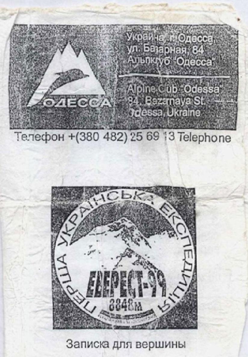
The note from the control tour was found in a severely damaged condition (unreadable and untransportable).
Note from the summit
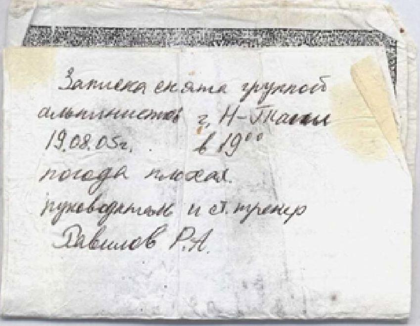
The note from the control tour was found in a severely damaged condition (unreadable and untransportable).

R22–R23 Litvinov, Ravilov preparing to pull up backpacks from the overnight stay location at R23
Photo illustration of the report
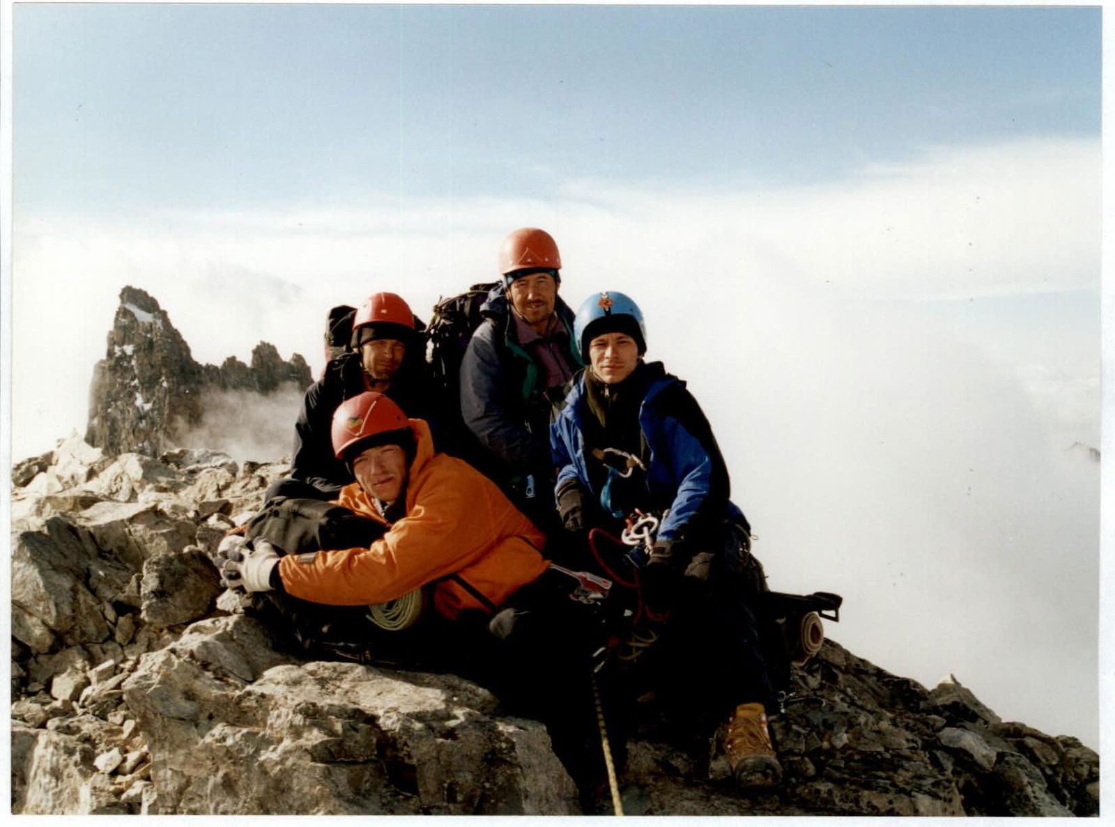
Group on the summit. In the background – Shkhelda East peak.
Route description
The route to Shkhelda Central via the center of the North wall can be conditionally divided into three characteristic sections:
- a not clearly expressed counterfort with a "tooth" in the lower part;
- the central wall;
- the summit tower.
The summit tower is a bastion with a steep North wall, separated from the Central wall by a snow belt.
The Central wall is a giant internal angle-"mirror" formed by almost 400-meter high sheer walls, the right walls of which border the "shovel" and gradually transition into a not clearly expressed counterfort descending to the Shkheldinsky glacier. The route starts from it.
R0–R1. Exit to the lower rocks of the "Tooth" and further movement along the right side of the slope. Rocks like "ram's foreheads", with difficult short walls in the lower part. Snowy slope and couloir to the right of the rocks are peppered with stones coming from the "shovel"!
R1–R2. After a snow patch, along the destroyed rocks along the snowy couloir – exit to the saddle.
R2–R3. From the saddle along a difficult wall – exit to the "ram's foreheads" with two ledges. On the upper one, under the shelter of a stone – overnight stay. The lower ledge is more convenient but offers no protection from rockfall.
R3–R4. From the ledge along a moderately steep snowy slope to the rocks. R4–R5. Movement along the rocks towards a small grotto (possible semi-reclining overnight stay for two).
R5–R6. From the grotto along rocks of medium difficulty, partly destroyed, upwards-left along a not clearly expressed edge, gradually turning into a steep slope.
R6–R7. Steep difficult wall. In the middle and upper parts – complex climbing.
R7–R8. Exit via short difficult walls into the couloir descending from the "shovel" and crossing it further under the walls of the "shovel". Rocks like "ram's foreheads", mossy, partly damp.
R9. Along a steep, partly vertical wall to small overhangs. Complex climbing on small, sloping holds, many damp areas.
R9–R10. Traverse upwards-left along inclined slabs along the overhanging walls to a large black overhang. Under its protection on small, rocky ledges – semi-reclining overnight stays scattered.
R10–R11. From the overnight stays, movement upwards-left along "ram's foreheads" of medium difficulty (many loose stones) to a rocky wall bounded on the right by a snow patch.
R11–R12. Along a difficult wall, overcome head-on, to a black chimney. R12–R13. Along the right side of the chimney with a plug in the upper part – exit to the rocky ledges under the base of the Central wall. Climbing is complex.
R13–R14. Movement upwards-left along short walls and ledges to a small snow patch.
R14–R15. Traverse along the ledges along the snow patch and, crossing a not clearly expressed edge, – exit under a steep wall.
On the rocky ledge at the snow patch – overnight stay. After several hours of work, a tent can be set up. 20 m below, there is another ledge where a site can be made.
R15–R16. First along the center, then along the right part of the steep, partly vertical wall with a small number of cracks and holds – exit to ledges in the form of "ram's foreheads". Climbing is complex, mainly sloping holds and micro-relief in the upper part.
R16–R17. Along the "ram's foreheads" – a small traverse upwards-left to smooth, vertical slabs.
R17–R18. Movement along the wall consisting of smooth slabs – to a large detached block.
R18–R19. Very difficult traverse left (8 m) to the chip along smooth, vertical slabs, further along the gap between the chip and the wall, towards the chips in the lower part of the internal angle of the North wall. Climbing is very complex, always on friction and in opposition. For belaying, large friends are necessary. Rocks are damp due to the "waterfall" flowing along the entire internal angle.
R20. System of chips. Complex climbing on smooth, slippery, damp rocks with many "living" blocks. Practically no places for belaying. Only in the upper part is it possible to organize a station without using pitons. The entire section is abundantly watered.
R20–R21. Along the internal angle turning into an overhanging wall, exit to an inclined rocky ledge with a gap in the middle. Climbing is very complex, in the middle and upper parts – extremely complex, but occasionally old, rusty pitons are found, which somewhat facilitates the passage.
The section is dry due to the overhang; water flies behind the back. On the ledge – sitting overnight stay, in principle dry – splashes hit the very edge of the ledge. Water can be collected from streams flowing along the rocks to the right and left of the ledge. On a piton – a control tour.
R21–R22. From the rocky ledge – very complex traverse left (40 m) behind the black stains to old pitons. Climbing is complicated by very slippery, damp rocks and a "living" rocky block, which must be bypassed from above.
R22–R23. After the traverse – straight up along the overhanging monolithic wall. Rocks are wet, relief is practically absent. The section is passed almost entirely on ITC, only in the upper part – about 20 m of extremely complex climbing on micro-relief. Old pitons are subjectively reliable and aid in passage.
R23–R24. The wall becomes less steep, but climbing remains very complex; individual sections must be passed on ITC. The wall ends with a small balcony.
R24–R25. From the balcony along difficult, smoothed, partly destroyed slabs upwards-right to the rocks of the snow belt.
R25–R26. Movement along the rocky islands of the snow belt towards the central couloir of the summit tower. Partly difficult walls, "ram's foreheads". The section is peppered with stones coming from the tower.
R26–R27. Along the black chimney on the right side of the central couloir – exit into the couloir and along its right side under the walls of the tower. Climbing is complex, rocks are destroyed.
R27–R28. Along the rocks of the summit tower upwards – exit to the summit. Difficult walls are encountered. Rocks are partly strongly destroyed and many "living" stones!
Tactical and technical actions of the team
In August 2005, a team of climbers from Nizhny Tagil made an ascent to the summit of Shkhelda Central (4295 m) via the "Mirror" on the S wall, Polevoy's route, 6B category of difficulty.
August 13, 2005
After registering with the Shkhelda Rescue Service (PSS "Shkhelda"), preliminarily studying all available information on the route and consulting on the Mountain and its North wall, slightly puzzled by the scarcity of data, we set out on the approach.
August 14, 2005
Divided into two groups, we went on reconnaissance.
- The first group ascended to the moraine under the Dvuyazychny glacier to view the wall and take photos.
- The second group approached the beginning of the route along the Shkheldinsky glacier to assess the snow and ice conditions.
Reconnaissance showed that since the first ascent of the route in 1971, the conditions had changed. The snow had melted significantly, the glaciers had retreated, and the ice had been exposed. In the lower part of the glacier flowing from the North wall of Shkhelda, an icefall had been exposed. It was constantly rumbling and crashing throughout the day. The snowy couloir leading to the saddle near the "Tooth" was peppered with stones throughout the day. Based on this, it was decided:
- to start the route along the rocky counterfort;
- to reach the same saddle.
This somewhat complicates the lower part of the route, lengthens it, but excludes the group being in the rockfall-prone couloir.
August 15, 2005
On the lateral moraine of the Shkheldinsky glacier, opposite Shkhelda Central, an observation and communication post was established. 8:00 – the weather is excellent, clear. We begin the ascent. We overcome the bergschrund via a fragile snowy bridge and start climbing the smooth "ram's foreheads". The first rope team is Litvinov–Khoroshilov.
To the right, along the couloir, something is constantly rolling down. Often, rappel rings and pitons are encountered. People have been here before...
At 14:00, having ascended 50 m above the saddle, we reach a good ledge. There are sites for tents, water, a daisy meadow, height 3103 m.
 We set up a bivouac. The rope team Gorshkov, Ravilov, Kononenko proceeds to further process the route along the not clearly expressed counterfort, going upwards-left parallel to the right edge of the North wall. At 18:00, it starts to rain stones heavily along the path of movement, with particularly large samples reaching almost to the tent. The processors quickly descend. One rope is damaged.
August 16, 2005
The weather is excellent, clear. At 9:00, the rope team Litvinov, Khoroshilov, Gorshkov continues to process the ridge above the overnight stay; climbing is not very complex. By 13:00, having worked through all the ropes, the team descends. Neither a suitable place for a "camp" (even talking about setting up a tent is out of the question) nor water is found. We have lunch... and decide to move higher to a suitable place for an overnight stay. At 15:00, we dismantle the camp and begin the ascent. At 18:00, it starts to rain stones heavily again along the lower part of the ridge. The complexity of climbing increases. Difficult walls are encountered. At 19:00, on a rocky ledge under the protection of an overhanging wall, we set up a bivouac.
Height: 3430 m.
Features of the overnight stay:
- Accommodation in pairs
- Semi-reclining, semi-sideways
- On a half-ledge
- Water is fetched with a rope from above
August 17, 2005
The weather is good, light cloudiness. Departure at 9:00. We continue moving along the Wall. Climbing is above average complexity. At 14:00, the leading rope team Litvinov, Khoroshilov, Ravilov approaches the key location and begins to process the "mirror" of the North wall. Under the wall, on a rocky ledge, we set up a bivouac. After упорной работы on the "rock quarries", we manage to set up a tent "on its end". There is snow, a daisy flowerbed, height 3628 m. At 19:00, the leading rope team descends to the overnight stay location.
August 18, 2005
The weather is bad, it's raining. Departure is delayed. Above the overnight stay – solid walls. Streams of water fall from the cornices along the right part of the "mirror". By 11:00, the rain stops, and the group continues processing. The complexity of climbing constantly increases, steepness grows.
Somewhere on this section (R18–R20), the first ascendants hid the control tour. We found it... The tour was on a ledge under the streams of the waterfall. From a rusty tin can, we extracted a completely soggy note. The text is illegible; it's a pity – the country won't know its heroes.
At 13:00, the rope team Litvinov–Gorshkov reaches a sloping ledge in the center of the "mirror". The ropes are finished. We decide to move the camp here. Height 3886 m. The overnight stay is sitting, separate, there's a piton. Water flows down the wall, and splashes fall from the cornice.
Litvinov–Gorshkov continue to process the "mirror", the rest "relocate" to the ledge. The leading pair moves left, avoiding the waterfalls. Climbing is extremely difficult, ITC.
At 20:00, the rope team Litvinov–Gorshkov finishes processing the "mirror" and descends to the overnight stay. Here, on a piton under the cornice, we tie our can. It will be the control tour: you can't miss it – you'll bump into it nose-first.
August 19, 2005
The weather is good, light cloudiness. Departure at 8:00. When passing the cornices on the traverse, safety ropes were натянуты for pulling up backpacks. The steepness gradually decreases, climbing becomes easier. At 12:00, the group gathers near the snow belt, under the summit tower. There's a convenient place for a bivouac, but it's heavily peppered with stones from the summit tower. Under the protection of a small wall, we have lunch and continue moving. Climbing is of medium complexity, sometimes difficult sections are encountered. At 19:00, the leading rope team Litvinov–Gorshkov reaches the summit of Shkhelda Central. On the summit ridge – a convenient bivouac: a site for a tent, snow.
August 20, 2005
Everything below is shrouded in clouds. Departure at 9:00. We begin the descent along the West ridge to the saddle under the 3rd Western Shkhelda (Aristov Peak).
According to the first ascent description, the further descent route goes South, to the South Shkheldinsky glacier. Currently, this is a violation of Russia's border. We descend North along the right edge of the North wall, Martynov's route 5B. Very rockfall-prone! Judging by the number of rappel rings and left ropes, this is the busiest "highway" on the entire Mountain.
At 20:00, we reached the location of the first overnight stay. We decide to stop, as we won't make it down to the glacier before dark, and the place is cozy – a meadow, daisies.
August 21, 2005
The weather is good, cloudy, the summits are shrouded. At 10:00, we continue the descent. Under the last participant, the snowy bridge over the bergschrund collapses. At 14:00, the group in full descends to the base camp on the moraine of the Shkheldinsky glacier.