ASCENT DOCUMENT
-
Ascent category: technical
-
Ascent area: Central Caucasus, Shkhelda gorge
-
III western Shkhelda (4229 m) via the north face of the northwest ridge (Kensitsky variation)
-
5B category of difficulty
-
Route characteristics: height difference — 1129 m, height difference of the route's wall section — 320 m, route length — 1630 m, length of the route's wall section — 340 m, length of 5–6 category of difficulty sections — 300 m, average steepness of the main part of the route — 52°, average steepness of the route's wall section — 72°.
-
Pitons driven: rock — 74, bolt — 118, chocks — 0, ice — 10.
-
Number of bivouacs: 1st: in a tent under the route. 2nd: in a tent in the "proval" (3800 m). 3rd: in a tent on Shkhelda plateau.
-
Team leader: Usas V.I., Candidate Master of Sports.
Team members:
- Pundzius E.V., Candidate Master of Sports
- Pundziuviene V.P., Candidate Master of Sports
- Paplauskas V.N., Candidate Master of Sports
-
Coach: Gudialis A.V.
-
Departure to the route: July 7, 1988, 5:00. Summit: July 8, 1988. Return: July 9, 1988.
-
Lithuanian SSR team.
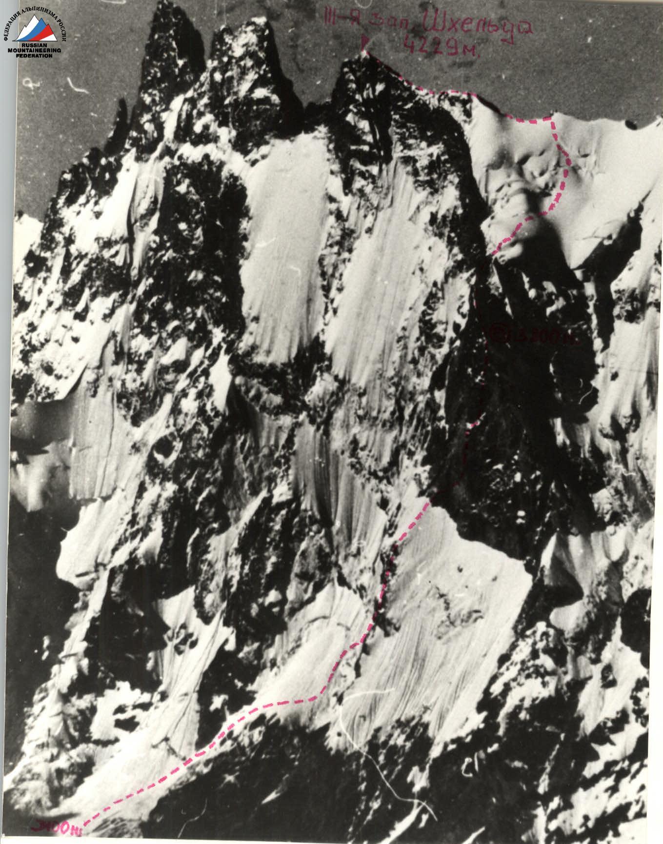
General photo of Shkhelda peak (3rd western — 4229 m). (0) — bivouac site; — — — ascent route.
Taken on July 25, 1988. Distance — about 3000 m. Camera "Zenit II", lens "HELIOS-44" 2/58. Height of the shooting point — about 3000 m.
Team's Technical Actions
The team completed the route without significant deviations from the tactical plan in terms of time and bivouac locations.
View from UMC "Elbrus" at 14:00. The team set up a bivouac under the route on the glacier in a safe location at 17:00. Until 20:00, the wall was observed. The following were determined:
- rockfall areas;
- safe belay locations under shelters.
The team started the route on July 7, 1988, at 5:00 am.
The weather was good from the morning. The snow was in good, firm condition. The team moved in crampons to the rocky ridge and along it. Due to the firm snow, reliable belays were organized using ice axes.
The second rocky belt was climbed over rocks. The team approached the wall section of the route at 9:00, without deviating from the tactical plan.
Due to objective reasons (rain, snow), the route conditions worsened, so the team arrived at the bivouac site in the "proval" at an altitude of 3800 m at 21:00, with a 1-hour deviation from the tactical plan.
July 8, 1988:
- departed from the bivouac at 6:00;
- reached the summit at 11:30.
The entire day was foggy.
On all complex wall sections, the team worked as follows:
The first climber — on a double rope (one with a UIAA marker). After organizing a reliable belay station, the first climber belays the second, who moves on fixed ropes. At the same time, the second pulls up the third rope, clipping it into carabiners.
After the second climber arrives at the belay station:
- they belay the third;
- the first climber prepares their gear and gets ready to move.
The third:
- ascends with top-rope belay on fixed ropes;
- adjusts the fixed ropes;
- removes unnecessary protection, pitons.
The lead and last climbers in the route changed roles once a day, approximately after 5–6 hours of work.
Sections:
- R0–R10 — Paplauskas V.N.;
- R11–R16 — Pundzius E.V.;
- R17–R20 — Usas V.I.;
- R21–R42 — Pundziuviene V.P.
Belay stations were chosen in protected locations — under overhangs, ledges.
The first aid kit was carried by the second climber, and each team member had an individual medical kit.
The first climber worked without a backpack.
All belay stations were organized on three to four interconnected anchors (stations).
The movement regime ensured maximum safety and speed, considering the terrain and rockfall hazard. Rest — about 7.5–8 hours for sleep.
Nutrition — 450 g per person per day of high-quality products, sublimates, and concentrates.
Bivouac organization:
- all bivouacs — in safe locations.
Result:
- no falls or injuries occurred;
- the team completed the route with a reserve of physical and psychological strength.
Communication was maintained using "Kaktus" radios.
Radio work:
- no mandatory radio communications were missed.
The assortment, quantity, and weight of the gear, fuel, and food taken on the route corresponded to the route's complexity.
On the route:
- no gear, items, etc. were left behind;
- the team, caring for the environment, left no trash.
The team completed the route with one bivouac in good time and with adherence to safety measures.
Route Diagram
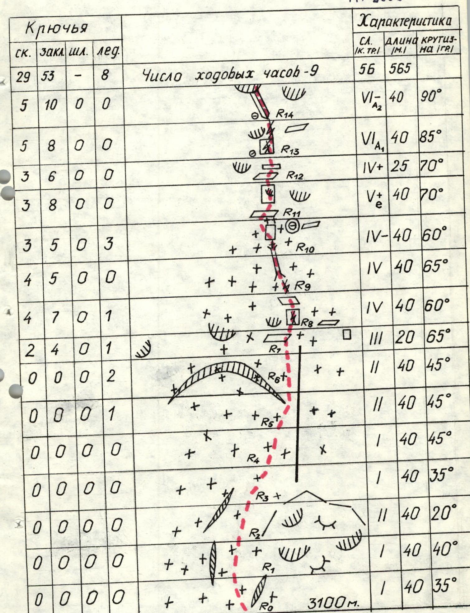
| Pitons (rock) | Pitons (chocks) | Pitons (bolt) | Pitons (ice) | Section | Category of difficulty | Length (m) | Steepness (°) |
|---|---|---|---|---|---|---|---|
| 0 | 0 | 0 | 0 | R0 | 1 | 40 | 35° |
| 0 | 0 | 0 | 0 | R1 | 1 | 40 | 40° |
| 0 | 0 | 0 | 0 | R2 | 2 | 40 | 20° |
| 0 | 0 | 0 | 0 | R3 | 1 | 40 | 35° |
| 0 | 0 | 0 | 0 | R4 | 1 | 40 | 45° |
| 0 | 0 | 0 | 1 | R5 | 2 | 40 | 45° |
| 0 | 0 | 0 | 2 | R6 | 2 | 40 | 45° |
| 2 | 4 | 0 | 1 | R7 | 3 | 20 | 65° |
| 4 | 7 | 0 | 1 | R8 | 4 | 40 | 60° |
| 4 | 5 | 0 | 0 | R9 | 4 | 40 | 65° |
| 3 | 5 | 0 | 3 | R10 | 4- | 40 | 60° |
| 3 | 8 | 0 | 0 | R11 | 5+ | 40 | 70° |
| 3 | 6 | 0 | 0 | R12 | 4+ | 25 | 70° |
| 5 | 8 | 0 | 0 | R13 | 6 | 40 | 85° |
| 5 | 10 | 0 | 0 | R14 | 6- | 40 | 90° |
| 4 | 6 | 0 | 0 | R15 | 5 | 40 | 80° |
| 6 | 7 | 0 | 0 | R16 | 5+ | 40 | 65° |
| 7 | 10 | 0 | 0 | R17 | 6+ | 40 | 95° |
| 4 | 5 | 0 | 0 | R18 | 5 | 20 | 70° |
| 6 | 8 | 0 | 0 | R19 | 5+ | 40 | 75° |
| 4 | 4 | 0 | 0 | R20 | 4+ | 15 | 60° |
| 3 | 4 | 0 | 0 | R21 | 4 | 40 | 60° |
| 2 | 2 | 0 | 0 | R22 | 2 | 40 | 60° |
| 3 | 4 | 0 | 0 | R23 | 3 | 40 | 50° |
| 0 | 0 | 0 | 0 | R24 | 2 | 40 | 25° |
| 1 | 3 | 0 | 0 | R25 | 2 | 40 | 45° |
| 3 | 3 | 0 | 1 | R26 | 3 | 40 | 50° |
| 2 | 4 | 0 | 1 | R27 | 3 | 40 | 50° |
| 0 | 2 | 1 | 0 | R28 | 2+ | 40 | 60° |
| 0 | 2 | 0 | 0 | R29 | 2 | 40 | 40° |
| 0 | 0 | 0 | 0 | R30 | 1 | 40 | 35° |
| 0 | 0 | 0 | 0 | R31 | 1 | 40 | 40° |
| 0 | 0 | 0 | 0 | R32 | 1 | 30 | 20° |
| 0 | 0 | 0 | 0 | R33 | 1 | 40 | 30° |
| 0 | 0 | 0 | 0 | R34 | 2 | 40 | 45° |
| 0 | 0 | 0 | 0 | R35 | 2 | 40 | 40° |
| 0 | 0 | 0 | 0 | R36 | 2 | 40 | 50° |
| 0 | 0 | 0 | 0 | R37 | 2 | 40 | 40° |
| 0 | 0 | 0 | 0 | R38 | 1 | 40 | 25° |
| 0 | 0 | 0 | 0 | R39 | 1 | 40 | 15° |
| 0 | 0 | 0 | 0 | R40 | 1 | 40 | 20° |
| 0 | 0 | 0 | 0 | R41 | 1 | 40 | 40° |
| 0 | 0 | 0 | 0 | R42 | 1 | 40 | 35° |
| Total: | 1630 | 52° |